 |
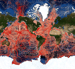
This data set contains bathymetry, magnetic, gravity and seismic shot point navigation
data collected during marine cruises from 1939 to the present. Coverage is worldwide.
These data are stored in the MGD77 exchange format and are available for download
in a variety of user selectable formats. One Header record and multiple Data records
are available for a particular cruise/leg (port to port operation). The Header record
documents both the content and the structure of the subsequent Data records, containing
that part of the data that remains invariant throughout the cruise. The Data records
present geophysical data (bathymetry, magnetics and gravity) and seismic information
(shot-point identification) with a corresponding time and position. Documentation
that varies within the cruise is also included with the data records. Data are fully
searchable on-line by geographic area, year of cruise, institution, platform, cruise,
date or data type. |