| NCEI Marine Geology Data Archive | spatialRepresentationInfo|
|---|---|
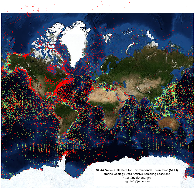
| а(MI_Metadata) ааааfileIdentifier: аgov.noaa.ngdc:Marine_Geology ааааhierarchyLevel: а(MD_ScopeCode)аdataset ааааcontact: а(CI_ResponsibleParty) ааааааааorganisationName: аNOAA National Centers for Environmental Information ааааааааcontactInfo: а(CI_Contact) ааааааааааааaddress: а(CI_Address) ааааааааааааааааelectronicMailAddress: аncei.info@noaa.gov ааааааааааааonlineResource: а(CI_OnlineResource) ааааааааааааааааlinkage: https://www.ncei.noaa.gov/contact ааааааааааааааааname: аNCEI Contact Information ааааааааааааааааdescription: аInformation for contacts at NCEI. ааааааааааааааааfunction: а(CI_OnLineFunctionCode)аinformation ааааааааrole: а(CI_RoleCode)аpointOfContact ааааdateStamp: а2020-05-04 ааааmetadataStandardName: аISO 19115-2 Geographic Information - Metadata - Part 2: Extensions for Imagery and Gridded Data ааааmetadataStandardVersion: аISO 19115-2:2009(E) return to top ааааspatialRepresentationInfo: а(MD_VectorSpatialRepresentation) ааааааааgeometricObjects: а(MD_GeometricObjects) ааааааааааааgeometricObjectType: а(MD_GeometricObjectTypeCode)аpoint return to top ааааreferenceSystemInfo: а(MD_ReferenceSystem) ааааааааreferenceSystemIdentifier: а(RS_Identifier) ааааааааааааauthority: а(CI_Citation) ааааааааааааааааtitle: аWorld Geodetic System 1984 ааааааааааааааааalternateTitle: аWGS 84 ааааааааааааааааdate: а(CI_Date) ааааааааааааааааааааdate: а2007-08-27 ааааааааааааааааааааdateType: а(CI_DateTypeCode)аrevision ааааааааааааааааcitedResponsibleParty: а(CI_ResponsibleParty) ааааааааааааааааааааorganisationName: (withheld) ааааааааааааааааааааcontactInfo: а(CI_Contact) ааааааааааааааааааааааааonlineResource: а(CI_OnlineResource) ааааааааааааааааааааааааааааlinkage: https://epsg.org/crs_4326/WGS-84.html ааааааааааааааааааааааааааааname: аWGS 84 ааааааааааааааааааааааааааааdescription: аGML of World Geodetic System 1984 coordinate reference system. ааааааааааааааааааааааааааааfunction: а(CI_OnLineFunctionCode)аinformation ааааааааааааааааааааrole: а(CI_RoleCode)аresourceProvider ааааааааааааааааcitedResponsibleParty: а(CI_ResponsibleParty) ааааааааааааааааааааorganisationName: аEuropean Petroleum Survey Group ааааааааааааааааааааcontactInfo: а(CI_Contact) ааааааааааааааааааааааааonlineResource: а(CI_OnlineResource) ааааааааааааааааааааааааааааlinkage: https://epsg.org/home.html ааааааааааааааааааааааааааааname: аEuropean Petroleum Survey Group Geodetic Parameter Registry ааааааааааааааааааааааааааааdescription: аRegistry that accesses the EPSG Geodetic Parameter Dataset, which is a structured dataset of Coordinate Reference Systems and Coordinate Transformations. ааааааааааааааааааааааааааааfunction: а(CI_OnLineFunctionCode)аsearch ааааааааааааааааааааrole: а(CI_RoleCode)аpublisher ааааааааааааcode: аurn:ogc:def:crs:EPSG::4326 return to top ааааidentificationInfo: а(MD_DataIdentification) ааааааааcitation: а(CI_Citation) ааааааааааааtitle: аNCEI Marine Geology Data Archive ааааааааааааdate: а(CI_Date) ааааааааааааааааdate: а1976-07-06 ааааааааааааааааdateType: а(CI_DateTypeCode)аpublication ааааааааааааdate: а(CI_Date) ааааааааааааааааdate: а2015-09-11 ааааааааааааааааdateType: а(CI_DateTypeCode)аrevision ааааааааааааedition: аFirst ааааааааааааidentifier: а(MD_Identifier) ааааааааааааааааauthority: а(CI_Citation) ааааааааааааааааааааtitle: аNOAA National Centers for Environmental Information ааааааааааааааааааааdate: (inapplicable) ааааааааааааааааcode: аNCEI Metadata ID: gov.noaa.ngdc:Marine_Geology ааааааааааааcitedResponsibleParty: а(CI_ResponsibleParty) ааааааааааааааааorganisationName: аMultiple investigators ааааааааааааааааrole: а(CI_RoleCode)аauthor ааааааааааааcitedResponsibleParty: а(CI_ResponsibleParty) ааааааааааааааааorganisationName: аMultiple projects, institutions, and agencies worldwide ааааааааааааааааrole: а(CI_RoleCode)аoriginator ааааааааааааcitedResponsibleParty: а(CI_ResponsibleParty) ааааааааааааааааorganisationName: аNOAA National Centers for Environmental Information ааааааааааааааааrole: а(CI_RoleCode)аpublisher ааааааааааааpresentationForm: а(CI_PresentationFormCode)аdigital ааааааааааааseries: а(CI_Series) ааааааааааааааааname: аMarine Geology and Geophysics (MGG) ааааааааааааааааissueIdentification: аMultiple MGG identifiers ааааааааabstract: аMarine Geologic data compilations and reports in the NCEI archive are from academic and government sources around the world. Over ten terabytes of analyses, descriptions, and images of sediment and rock from the ocean floor and lakebeds are available. Examples of data available include sediment/rock composition, physical properties, petrology/mineralogy, geochemistry, paleontology, paleomagnetism, x-rays, photographs, and other imagery. All reports and data, regardless of format, are accessible via the Marine Geology Digital Inventory and/or linked to the Index to Marine and Lacustrine Geological Samples (IMLGS). Searches offer free, immediate download of digital data, many images, and .PDF reports, and information on how to obtain full-resolution images from the archive, and order CD-ROMs, microfilm, or oversize charts. Some larger data sets, including the IMLGS, have their own web interfaces. The IMLGS provides searches of sea floor and lakebed cores, grabs, dredges, and drill samples available from sample repositories at partner institutions, with links to browse and download related information from NCEI and other sources. ааааааааpurpose: аResearch in global change, benthic habitats, mineral resources, and environmental processes. ааааааааcredit: аMarine geology data in the NCEI archive are from diverse projects and programs, and were funded by many sources around the world, for example the National Science Foundation (NSF). Please cite the original source when using these data. Many of the core and seabed photographs and descriptions in the archive were digitized under Project L-19 of the NOAA Climate Data Modernization Program (CDMP). Project L-19 was a partnership between NGDC and several institutions to digitize, make available, and archive analog data from their collections. ааааааааstatus: а(MD_ProgressCode)аonGoing ааааааааstatus: а(MD_ProgressCode)аhistoricalArchive ааааааааpointOfContact: а(CI_ResponsibleParty) ааааааааааааorganisationName: аNOAA National Centers for Environmental Information ааааааааааааcontactInfo: а(CI_Contact) ааааааааааааааааaddress: а(CI_Address) ааааааааааааааааааааelectronicMailAddress: аncei.info@noaa.gov ааааааааааааааааonlineResource: а(CI_OnlineResource) ааааааааааааааааааааlinkage: https://www.ncei.noaa.gov/contact ааааааааааааааааааааname: аNCEI Contact Information ааааааааааааааааааааdescription: аInformation for contacts at NCEI. ааааааааааааааааааааfunction: а(CI_OnLineFunctionCode)аinformation ааааааааааааrole: а(CI_RoleCode)аpointOfContact ааааааааpointOfContact: а(CI_ResponsibleParty) ааааааааааааorganisationName: аNOAA National Centers for Environmental Information ааааааааааааpositionName: аMarine Geology Data Manager ааааааааааааcontactInfo: а(CI_Contact) ааааааааааааааааaddress: а(CI_Address) ааааааааааааааааааааdeliveryPoint: а325 Broadway, Mail Code E/NE42 ааааааааааааааааааааcity: аBoulder ааааааааааааааааааааadministrativeArea: аCO ааааааааааааааааааааpostalCode: а80305-3328 ааааааааааааааааааааcountry: аUSA ааааааааааааааааааааelectronicMailAddress: аgeology.info@noaa.gov ааааааааааааrole: а(CI_RoleCode)аpointOfContact ааааааааresourceMaintenance: а(MD_MaintenanceInformation) ааааааааааааmaintenanceAndUpdateFrequency: а(MD_MaintenanceFrequencyCode)аirregular ааааааааааааmaintenanceNote: аAdditions as new data are received. ааааааааgraphicOverview: а(MD_BrowseGraphic) ааааааааааааfileName: https://www.ngdc.noaa.gov/mgg/image/geology_mercator2048.png ааааааааааааfileDescription: аdata locations ааааааааааааfileType: аPNG ааааааааdescriptiveKeywords: а(MD_Keywords) ааааааааааааkeyword: аIMLGS > Index to Marine and Lacustrine Geological Samples ааааааааааааkeyword: аDOMES > Deep Ocean Mining Environmental Study ааааааааааааkeyword: аIDOE > International Decade of Ocean Exploration ааааааааааааkeyword: аIODP > INTEGRATED OCEAN DRILLING PROGRAM ааааааааааааkeyword: аIPOD > International Phase of Ocean Drilling ааааааааааааkeyword: аOCSEAP > Outer Continental Shelf Environmental Assessment Project ааааааааааааkeyword: аODP > OCEAN DRILLING PROGRAM ааааааааааааkeyword: аODP/DSDP > Ocean Drilling Program / Deep Sea Drilling Program ааааааааааааkeyword: аSEATAR > Studies of East Asia Tectonics and Resources ааааааааааааkeyword: аSOUTH.CAL.OCS BASELINE ааааааааааааtype: а(MD_KeywordTypeCode)аproject ааааааааааааthesaurusName: а(CI_Citation) ааааааааааааааааtitle: аGlobal Change Master Directory (GCMD) Project Keywords ааааааааааааааааdate: а(CI_Date) ааааааааааааааааааааdate: а2020-01-09 ааааааааааааааааааааdateType: а(CI_DateTypeCode)аpublication ааааааааааааааааedition: а9.1 ааааааааааааааааcitedResponsibleParty: а(CI_ResponsibleParty) ааааааааааааааааааааorganisationName: аNASA Goddard Space Flight Center, Earth Science Data and Information System ааааааааааааааааааааcontactInfo: а(CI_Contact) ааааааааааааааааааааааааonlineResource: а(CI_OnlineResource) ааааааааааааааааааааааааааааlinkage: https://www.earthdata.nasa.gov/learn/find-data/idn/gcmd-keywords ааааааааааааааааааааааааааааname: аGlobal Change Master Directory (GCMD) Keywords ааааааааааааааааааааааааааааdescription: аThe information provided on this page seeks to define how the GCMD Keywords are structured, used and accessed. It also provides information on how users can participate in the further development of the keywords. ааааааааааааааааааааааааааааfunction: а(CI_OnLineFunctionCode)аinformation ааааааааааааааааааааrole: а(CI_RoleCode)аcustodian ааааааааdescriptiveKeywords: а(MD_Keywords) ааааааааааааkeyword: аDatabases ааааааааааааkeyword: аScientific archives ааааааааааааkeyword: аElectronic records ааааааааааааkeyword: аOceanography ааааааааааааkeyword: аOcean bottom ааааааааааааkeyword: аGeology ааааааааааааkeyword: аSubmarine geology ааааааааааааkeyword: аMarine sediments ааааааааааааkeyword: аGeochemistry ааааааааааааkeyword: аMarine mineral resources ааааааааааааkeyword: аManganese nodules ааааааааааааtype: а(MD_KeywordTypeCode)аtheme ааааааааааааthesaurusName: а(CI_Citation) ааааааааааааааааtitle: аLibrary of Congress Subject Headings ааааааааааааааааdate: (unknown) ааааааааааааааааcitedResponsibleParty: а(CI_ResponsibleParty) ааааааааааааааааааааorganisationName: аUS Library of Congress ааааааааааааааааааааcontactInfo: а(CI_Contact) ааааааааааааааааааааааааonlineResource: а(CI_OnlineResource) ааааааааааааааааааааааааааааlinkage: http://id.loc.gov/authorities/subjects ааааааааааааааааааааааааааааprotocol: аhttp ааааааааааааааааааааааааааааapplicationProfile: аweb browser ааааааааааааааааааааааааааааname: аLibrary of Congress Subject Headings (LCSH) ааааааааааааааааааааааааааааdescription: аThe Library of Congress Subject Headings (LCSH) are part of a Linked Data Service, actively maintained since 1898 to catalog materials held at the Library of Congress. ааааааааааааааааааааааааааааfunction: а(CI_OnLineFunctionCode)аinformation ааааааааааааааааааааrole: а(CI_RoleCode)аresourceProvider ааааааааdescriptiveKeywords: а(MD_Keywords) ааааааааааааkeyword: аMarine geology ааааааааааааkeyword: аRock and sediment lithology and mineralogy ааааааааааааkeyword: аRock and sediment chemistry ааааааааааааkeyword: аRock and sediment physical properties ааааааааааааkeyword: аUnderwater photography ааааааааааааkeyword: аGeothermal measurements ааааааааааааtype: а(MD_KeywordTypeCode)аtheme ааааааааааааthesaurusName: а(CI_Citation) ааааааааааааааааtitle: аSeaDataNet Common Vocabularies ааааааааааааааааdate: (unknown) ааааааааааааааааcitedResponsibleParty: а(CI_ResponsibleParty) ааааааааааааааааааааorganisationName: аSeaDataNet ааааааааааааааааааааcontactInfo: а(CI_Contact) ааааааааааааааааааааааааonlineResource: а(CI_OnlineResource) ааааааааааааааааааааааааааааlinkage: http://www.seadatanet.org/Standards-Software/Common-Vocabularies ааааааааааааааааааааааааааааprotocol: аhttp ааааааааааааааааааааааааааааapplicationProfile: аweb browser ааааааааааааааааааааааааааааname: аSeaDataNet Common Vocabularies ааааааааааааааааааааааааааааdescription: аThe SeaDataNet Vocabulary Server is populated with lists describing a wide range of entities relevant to marine metadata and data such as parameters, sea area names, platform classes, instrument types, and so on. ааааааааааааааааааааааааааааfunction: а(CI_OnLineFunctionCode)аinformation ааааааааааааааааааааrole: а(CI_RoleCode)аresourceProvider ааааааааdescriptiveKeywords: а(MD_Keywords) ааааааааааааkeyword: аSea-floor characteristics ааааааааааааtype: а(MD_KeywordTypeCode)аtheme ааааааааааааthesaurusName: а(CI_Citation) ааааааааааааааааtitle: аUSGS Science Topics ааааааааааааааааdate: (unknown) ааааааааааааааааcitedResponsibleParty: а(CI_ResponsibleParty) ааааааааааааааааааааorganisationName: аUS Geological Survey ааааааааааааааааааааcontactInfo: а(CI_Contact) ааааааааааааааааааааааааonlineResource: а(CI_OnlineResource) ааааааааааааааааааааааааааааlinkage: https://www2.usgs.gov/science/about/ ааааааааааааааааааааааааааааprotocol: аhttp ааааааааааааааааааааааааааааapplicationProfile: аweb browser ааааааааааааааааааааааааааааname: аUSGS Thesaurus ааааааааааааааааааааааааааааdescription: аThe USGS Thesaurus contains thematic terms for categorizing information resources intended to support finding and understanding scientific information. ааааааааааааааааааааааааааааfunction: а(CI_OnLineFunctionCode)аinformation ааааааааааааааааааааrole: а(CI_RoleCode)аresourceProvider ааааааааdescriptiveKeywords: а(MD_Keywords) ааааааааааааkeyword: аlacustrine sediments ааааааааааааtype: а(MD_KeywordTypeCode)аtheme ааааааааааааthesaurusName: а(CI_Citation) ааааааааааааааааtitle: аUSDA National Agricultural Library's Agricultural Thesaurus (NALT) ааааааааааааааааdate: (unknown) ааааааааааааааааcitedResponsibleParty: а(CI_ResponsibleParty) ааааааааааааааааааааorganisationName: аUSDA National Agricultural Library ааааааааааааааааааааcontactInfo: а(CI_Contact) ааааааааааааааааааааааааonlineResource: а(CI_OnlineResource) ааааааааааааааааааааааааааааlinkage: http://agclass.nal.usda.gov/ ааааааааааааааааааааааааааааprotocol: аhttp ааааааааааааааааааааааааааааapplicationProfile: аweb browser ааааааааааааааааааааааааааааname: аNAL Agricultural Thesaurus (NALT) ааааааааааааааааааааааааааааdescription: аThe US Department of Agriculture, National Agricultural Library's (NAL) Agricultural Thesaurus (NALT). ааааааааааааааааааааааааааааfunction: а(CI_OnLineFunctionCode)аinformation ааааааааааааааааааааrole: а(CI_RoleCode)аresourceProvider ааааааааdescriptiveKeywords: а(MD_Keywords) ааааааааааааkeyword: аEARTH SCIENCE > Oceans > Marine Sediments > Geotechnical Properties ааааааааааааkeyword: аEARTH SCIENCE > Oceans > Marine Sediments > Sediment Chemistry ааааааааааааkeyword: аEARTH SCIENCE > Oceans > Marine Sediments > Sediment Composition ааааааааааааkeyword: аEARTH SCIENCE > Oceans > Marine Sediments > Sedimentary Textures ааааааааааааkeyword: аEARTH SCIENCE > Paleoclimate > Ocean/Lake Records > Boreholes ааааааааааааkeyword: аEARTH SCIENCE > Paleoclimate > Ocean/Lake Records > Isotopes ааааааааааааkeyword: аEARTH SCIENCE > Paleoclimate > Ocean/Lake Records > Microfossils ааааааааааааkeyword: аEARTH SCIENCE > Paleoclimate > Ocean/Lake Records > Paleomagnetic Data ааааааааааааkeyword: аEARTH SCIENCE > Paleoclimate > Ocean/Lake Records > Sediments ааааааааааааkeyword: аEARTH SCIENCE > Solid Earth > Rocks/Minerals/Crystals > Major Elements ааааааааааааkeyword: аEARTH SCIENCE > Solid Earth > Rocks/Minerals/Crystals > Minor Elements ааааааааааааkeyword: аEARTH SCIENCE > Solid Earth > Rocks/Minerals/Crystals > Trace Elements ааааааааааааkeyword: аEARTH SCIENCE > Solid Earth > Geomagnetism > Paleomagnetism ааааааааааааkeyword: аEARTH SCIENCE > Solid Earth > Rocks/Minerals/Crystals > Age Determinations ааааааааааааkeyword: аEARTH SCIENCE > Solid Earth > Rocks/Minerals/Crystals > Igneous Rocks ааааааааааааkeyword: аEARTH SCIENCE > Solid Earth > Rocks/Minerals/Crystals > Metamorphic Rocks ааааааааааааkeyword: аEARTH SCIENCE > Solid Earth > Rocks/Minerals/Crystals > Sedimentary Rocks ааааааааааааkeyword: аEARTH SCIENCE > Solid Earth > Rocks/Minerals/Crystals > Sediments ааааааааааааkeyword: аEARTH SCIENCE > OCEANS > Marine Sediments > Stratigraphic Sequence ааааааааааааkeyword: аEARTH SCIENCE > PALEOCLIMATE > Ocean/Lake Records > Stratigraphic Sequence ааааааааааааtype: а(MD_KeywordTypeCode)аtheme ааааааааааааthesaurusName: а(CI_Citation) ааааааааааааааааtitle: аGlobal Change Master Directory (GCMD) Science Keywords ааааааааааааааааdate: а(CI_Date) ааааааааааааааааааааdate: а2020-01-09 ааааааааааааааааааааdateType: а(CI_DateTypeCode)аpublication ааааааааааааааааedition: а9.1 ааааааааааааааааcitedResponsibleParty: а(CI_ResponsibleParty) ааааааааааааааааааааorganisationName: аNASA Goddard Space Flight Center, Earth Science Data and Information System ааааааааааааааааааааcontactInfo: а(CI_Contact) ааааааааааааааааааааааааonlineResource: а(CI_OnlineResource) ааааааааааааааааааааааааааааlinkage: https://www.earthdata.nasa.gov/learn/find-data/idn/gcmd-keywords ааааааааааааааааааааааааааааname: аGlobal Change Master Directory (GCMD) Keywords ааааааааааааааааааааааааааааdescription: аThe information provided on this page seeks to define how the GCMD Keywords are structured, used and accessed. It also provides information on how users can participate in the further development of the keywords. ааааааааааааааааааааааааааааfunction: а(CI_OnLineFunctionCode)аinformation ааааааааааааааааааааrole: а(CI_RoleCode)аcustodian ааааааааdescriptiveKeywords: а(MD_Keywords) ааааааааааааkeyword: аIn Situ Ocean-based Platforms > SHIPS ааааааааааааtype: а(MD_KeywordTypeCode)аplatform ааааааааааааthesaurusName: а(CI_Citation) ааааааааааааааааtitle: аGlobal Change Master Directory (GCMD) Platform Keywords ааааааааааааааааdate: а(CI_Date) ааааааааааааааааааааdate: а2020-01-09 ааааааааааааааааааааdateType: а(CI_DateTypeCode)аpublication ааааааааааааааааedition: а9.1 ааааааааааааааааcitedResponsibleParty: а(CI_ResponsibleParty) ааааааааааааааааааааorganisationName: аNASA Goddard Space Flight Center, Earth Science Data and Information System ааааааааааааааааааааcontactInfo: а(CI_Contact) ааааааааааааааааааааааааonlineResource: а(CI_OnlineResource) ааааааааааааааааааааааааааааlinkage: https://www.earthdata.nasa.gov/learn/find-data/idn/gcmd-keywords ааааааааааааааааааааааааааааname: аGlobal Change Master Directory (GCMD) Keywords ааааааааааааааааааааааааааааdescription: аThe information provided on this page seeks to define how the GCMD Keywords are structured, used and accessed. It also provides information on how users can participate in the further development of the keywords. ааааааааааааааааааааааааааааfunction: а(CI_OnLineFunctionCode)аinformation ааааааааааааааааааааrole: а(CI_RoleCode)аcustodian ааааааааdescriptiveKeywords: а(MD_Keywords) ааааааааааааkeyword: аIn Situ/Laboratory Instruments > Corers > CORING DEVICES ааааааааааааkeyword: аIn Situ/Laboratory Instruments > Samplers > DREDGING DEVICES ааааааааааааkeyword: аIn Situ/Laboratory Instruments > Samplers > Grabbers/Traps/Collectors > GRAB SAMPLERS ааааааааааааkeyword: аIn Situ/Laboratory Instruments > Corers > ROCK CORERS ааааааааааааkeyword: аIn Situ/Laboratory Instruments > Corers > SEDIMENT CORERS ааааааааааааkeyword: аIn Situ/Laboratory Instruments > Samplers > Trawls/Nets > BOTTOM TRAWL ааааааааааааtype: а(MD_KeywordTypeCode)аinstrument ааааааааааааthesaurusName: а(CI_Citation) ааааааааааааааааtitle: аGlobal Change Master Directory (GCMD) Instrument Keywords ааааааааааааааааdate: а(CI_Date) ааааааааааааааааааааdate: а2020-01-09 ааааааааааааааааааааdateType: а(CI_DateTypeCode)аpublication ааааааааааааааааedition: а9.1 ааааааааааааааааcitedResponsibleParty: а(CI_ResponsibleParty) ааааааааааааааааааааorganisationName: аNASA Goddard Space Flight Center, Earth Science Data and Information System ааааааааааааааааааааcontactInfo: а(CI_Contact) ааааааааааааааааааааааааonlineResource: а(CI_OnlineResource) ааааааааааааааааааааааааааааlinkage: https://www.earthdata.nasa.gov/learn/find-data/idn/gcmd-keywords ааааааааааааааааааааааааааааname: аGlobal Change Master Directory (GCMD) Keywords ааааааааааааааааааааааааааааdescription: аThe information provided on this page seeks to define how the GCMD Keywords are structured, used and accessed. It also provides information on how users can participate in the further development of the keywords. ааааааааааааааааааааааааааааfunction: а(CI_OnLineFunctionCode)аinformation ааааааааааааааааааааrole: а(CI_RoleCode)аcustodian ааааааааdescriptiveKeywords: а(MD_Keywords) ааааааааааааkeyword: аICSU-WDS > International Council for Science - World Data System ааааааааааааtype: а(MD_KeywordTypeCode)аproject ааааааааааааthesaurusName: а(CI_Citation) ааааааааааааааааtitle: аGlobal Change Master Directory (GCMD) Project Keywords ааааааааааааааааdate: а(CI_Date) ааааааааааааааааааааdate: а2020-01-09 ааааааааааааааааааааdateType: а(CI_DateTypeCode)аpublication ааааааааааааааааedition: а9.1 ааааааааааааааааcitedResponsibleParty: а(CI_ResponsibleParty) ааааааааааааааааааааorganisationName: аNASA Goddard Space Flight Center, Earth Science Data and Information System ааааааааааааааааааааcontactInfo: а(CI_Contact) ааааааааааааааааааааааааonlineResource: а(CI_OnlineResource) ааааааааааааааааааааааааааааlinkage: https://www.earthdata.nasa.gov/learn/find-data/idn/gcmd-keywords ааааааааааааааааааааааааааааname: аGlobal Change Master Directory (GCMD) Keywords ааааааааааааааааааааааааааааdescription: аThe information provided on this page seeks to define how the GCMD Keywords are structured, used and accessed. It also provides information on how users can participate in the further development of the keywords. ааааааааааааааааааааааааааааfunction: а(CI_OnLineFunctionCode)аinformation ааааааааааааааааааааrole: а(CI_RoleCode)аcustodian ааааааааdescriptiveKeywords: а(MD_Keywords) ааааааааааааkeyword: аSolid Earth > Crust ааааааааааааkeyword: аGeographic Region > Global Ocean ааааааааааааkeyword: аVertical Location > Sea Floor ааааааааааааtype: а(MD_KeywordTypeCode)аplace ааааааааааааthesaurusName: а(CI_Citation) ааааааааааааааааtitle: аGlobal Change Master Directory (GCMD) Location Keywords ааааааааааааааааdate: а(CI_Date) ааааааааааааааааааааdate: а2020-01-09 ааааааааааааааааааааdateType: а(CI_DateTypeCode)аpublication ааааааааааааааааedition: а9.1 ааааааааааааааааcitedResponsibleParty: а(CI_ResponsibleParty) ааааааааааааааааааааorganisationName: аNASA Goddard Space Flight Center, Earth Science Data and Information System ааааааааааааааааааааcontactInfo: а(CI_Contact) ааааааааааааааааааааааааonlineResource: а(CI_OnlineResource) ааааааааааааааааааааааааааааlinkage: https://www.earthdata.nasa.gov/learn/find-data/idn/gcmd-keywords ааааааааааааааааааааааааааааname: аGlobal Change Master Directory (GCMD) Keywords ааааааааааааааааааааааааааааdescription: аThe information provided on this page seeks to define how the GCMD Keywords are structured, used and accessed. It also provides information on how users can participate in the further development of the keywords. ааааааааааааааааааааааааааааfunction: а(CI_OnLineFunctionCode)аinformation ааааааааааааааааааааrole: а(CI_RoleCode)аcustodian ааааааааdescriptiveKeywords: а(MD_Keywords) ааааааааааааkeyword: аDOC/NOAA/NESDIS/NCEI > National Centers for Environmental Information, NESDIS, NOAA, U.S. Department of Commerce ааааааааааааkeyword: аDOC/NOAA/NESDIS/NGDC > National Geophysical Data Center, NESDIS, NOAA, U.S. Department of Commerce ааааааааааааtype: а(MD_KeywordTypeCode)аdataCentre ааааааааааааthesaurusName: а(CI_Citation) ааааааааааааааааtitle: аGlobal Change Master Directory (GCMD) Data Center Keywords ааааааааааааааааdate: а(CI_Date) ааааааааааааааааааааdate: а2020-01-09 ааааааааааааааааааааdateType: а(CI_DateTypeCode)аpublication ааааааааааааааааedition: а9.1 ааааааааааааааааcitedResponsibleParty: а(CI_ResponsibleParty) ааааааааааааааааааааorganisationName: аNASA Goddard Space Flight Center, Earth Science Data and Information System ааааааааааааааааааааcontactInfo: а(CI_Contact) ааааааааааааааааааааааааonlineResource: а(CI_OnlineResource) ааааааааааааааааааааааааааааlinkage: https://www.earthdata.nasa.gov/learn/find-data/idn/gcmd-keywords ааааааааааааааааааааааааааааname: аGlobal Change Master Directory (GCMD) Keywords ааааааааааааааааааааааааааааdescription: аThe information provided on this page seeks to define how the GCMD Keywords are structured, used and accessed. It also provides information on how users can participate in the further development of the keywords. ааааааааааааааааааааааааааааfunction: а(CI_OnLineFunctionCode)аinformation ааааааааааааааааааааrole: а(CI_RoleCode)аcustodian ааааааааresourceConstraints: а(MD_LegalConstraints) ааааааааааааaccessConstraints: а(MD_RestrictionCode)аotherRestrictions ааааааааааааotherConstraints: аDistribution liability: NOAA and NCEI make no warranty, expressed or implied, regarding these data, nor does the fact of distribution constitute such a warranty. NOAA and NCEI cannot assume liability for any damages caused by any errors or omissions in these data. If appropriate, NCEI can only certify that the data it distributes are an authentic copy of the records that were accepted for inclusion in the NCEI archives. ааааааааresourceConstraints: а(MD_LegalConstraints) ааааааааааааuseConstraints: а(MD_RestrictionCode)аotherRestrictions ааааааааааааotherConstraints: аUse liability: NOAA and NCEI cannot provide any warranty as to the accuracy, reliability, or completeness of furnished data. Users assume responsibility to determine the usability of these data. The user is responsible for the results of any application of this data for other than its intended purpose. ааааааааresourceConstraints: а(MD_LegalConstraints) ааааааааааааuseLimitation: а(MD_RestrictionCode)аotherRestrictions ааааааааааааotherConstraints: аPlease cite DOIs for individual data sets. If no DOI is available, cite the data set originator, the date downloaded, and NOAA/NCEI as the source of the data. ааааааааresourceConstraints: а(MD_LegalConstraints) ааааааааааааaccessConstraints: а(MD_RestrictionCode)аotherRestrictions ааааааааааааotherConstraints: аAccess to this dataset is unrestricted. ааааааааresourceConstraints: а(MD_Constraints) ааааааааааааuseLimitation: аProduced by the NOAA National Centers for Environmental Information. Not subject to copyright protection within the United States. ааааааааaggregationInfo: а(MD_AggregateInformation) ааааааааааааaggregateDataSetName: а(CI_Citation) ааааааааааааааааtitle: аNOAA/NCEI Marine Geology WAF ааааааааааааааааdate: а(CI_Date) ааааааааааааааааааааdate: а2015-10-05 ааааааааааааааааааааdateType: а(CI_DateTypeCode) ааааааааааааааааcitedResponsibleParty: а(CI_ResponsibleParty) ааааааааааааааааааааorganisationName: аNOAA National Centers for Environmental Information ааааааааааааааааааааrole: а(CI_RoleCode)аauthor ааааааааааааааааcitedResponsibleParty: а(CI_ResponsibleParty) ааааааааааааааааааааorganisationName: (inapplicable) ааааааааааааааааааааcontactInfo: а(CI_Contact) ааааааааааааааааааааааааonlineResource: а(CI_OnlineResource) ааааааааааааааааааааааааааааlinkage: https://data.noaa.gov/waf/NOAA/NESDIS/NGDC/MGG/Geology/iso/ ааааааааааааааааааааааааааааprotocol: аWWW:LINK-1.0-http--link ааааааааааааааааааааааааааааapplicationProfile: аWeb Browser ааааааааааааааааааааааааааааname: аMarine geology metadata records. ааааааааааааааааааааааааааааfunction: а(CI_OnLineFunctionCode)аsearch ааааааааааааааааааааrole: (inapplicable) ааааааааааааassociationType: а(DS_AssociationTypeCode)аcrossReference ааааааааааааinitiativeType: а(DS_InitiativeTypeCode)аcollection ааааааааaggregationInfo: а(MD_AggregateInformation) ааааааааааааaggregateDataSetName: а(CI_Citation) ааааааааааааааааtitle: аIndex to Marine and Lacustrine Geological Samples (IMLGS) ааааааааааааааааdate: а(CI_Date) ааааааааааааааааааааdate: а2006-12-31 ааааааааааааааааааааdateType: а(CI_DateTypeCode) ааааааааааааааааidentifier: а(MD_Identifier) ааааааааааааааааааааcode: ааааааааааааааааааааааAnchor: аDOIаdoi:10.7289/V5H41PB8 ааааааааааааааааcitedResponsibleParty: а(CI_ResponsibleParty) ааааааааааааааааааааorganisationName: аNational Centers for Environmental Information, NOAA ааааааааааааааааааааrole: а(CI_RoleCode)аresourceProvider ааааааааааааааааcitedResponsibleParty: а(CI_ResponsibleParty) ааааааааааааааааааааorganisationName: (withheld) ааааааааааааааааааааcontactInfo: а(CI_Contact) ааааааааааааааааааааааааonlineResource: а(CI_OnlineResource) ааааааааааааааааааааааааааааlinkage: https://doi.org/10.7289/V5H41PB8 ааааааааааааааааааааааааааааprotocol: аWWW:LINK-1.0-http--link ааааааааааааааааааааааааааааapplicationProfile: аWeb Browser ааааааааааааааааааааааааааааname: аIndex to Marine and Lacustrine Geological Samples (IMLGS) ааааааааааааааааааааааааааааdescription: аThe IMLGS (doi:10.7289/V5H41PB8) provides information about geosamples curated by partner repositories, and access to related data stewarded by NOAA's National Centers for Environmental Information, or available from partner institutions and programs. ааааааааааааааааааааааааааааfunction: а(CI_OnLineFunctionCode)аsearch ааааааааааааааааааааrole: (inapplicable) ааааааааааааassociationType: а(DS_AssociationTypeCode)аcrossReference ааааааааааааinitiativeType: а(DS_InitiativeTypeCode)аproject ааааааааaggregationInfo: а(MD_AggregateInformation) ааааааааааааaggregateDataSetName: а(CI_Citation) ааааааааааааааааtitle: аNOAA/NCEI Marine Trackline Geophysics Database Metadata ааааааааааааааааdate: а(CI_Date) ааааааааааааааааааааdate: а1975-12-31 ааааааааааааааааааааdateType: а(CI_DateTypeCode) ааааааааааааааааcitedResponsibleParty: а(CI_ResponsibleParty) ааааааааааааааааааааorganisationName: аNational Centers for Environmental Information, NOAA ааааааааааааааааааааrole: а(CI_RoleCode)аresourceProvider ааааааааааааааааcitedResponsibleParty: а(CI_ResponsibleParty) ааааааааааааааааааааorganisationName: (withheld) ааааааааааааааааааааcontactInfo: а(CI_Contact) ааааааааааааааааааааааааonlineResource: а(CI_OnlineResource) ааааааааааааааааааааааааааааlinkage: https://data.noaa.gov/metaview/page?xml=NOAA/NESDIS/NGDC/Collection//iso/xml/G00129.xml&view=getDataView&header=none ааааааааааааааааааааааааааааprotocol: аWWW:LINK-1.0-http--link ааааааааааааааааааааааааааааapplicationProfile: аWeb Browser ааааааааааааааааааааааааааааname: аNOAA/NCEI Geophysical Survey data ааааааааааааааааааааааааааааdescription: аRelated trackline geophysical data (navigation, magnetics, gravity, bathymetry) for many geosampling cruises from NOAA's National Centers for Environmental Information. ааааааааааааааааааааааааааааfunction: а(CI_OnLineFunctionCode)аsearch ааааааааааааааааааааrole: (inapplicable) ааааааааааааassociationType: а(DS_AssociationTypeCode)аcrossReference ааааааааааааinitiativeType: а(DS_InitiativeTypeCode)аcollection ааааааааaggregationInfo: а(MD_AggregateInformation) ааааааааааааaggregateDataSetName: а(CI_Citation) ааааааааааааааааtitle: аNOAA/NCEI Paleoclimatology Data ааааааааааааааааdate: а(CI_Date) ааааааааааааааааааааdate: а2015-06-24 ааааааааааааааааааааdateType: а(CI_DateTypeCode) ааааааааааааааааcitedResponsibleParty: а(CI_ResponsibleParty) ааааааааааааааааааааorganisationName: аNational Centers for Environmental Information, NOAA ааааааааааааааааааааrole: а(CI_RoleCode)аresourceProvider ааааааааааааааааcitedResponsibleParty: а(CI_ResponsibleParty) ааааааааааааааааааааorganisationName: (withheld) ааааааааааааааааааааcontactInfo: а(CI_Contact) ааааааааааааааааааааааааonlineResource: а(CI_OnlineResource) ааааааааааааааааааааааааааааlinkage: https://www.ncdc.noaa.gov/data-access/paleoclimatology-data/ ааааааааааааааааааааааааааааprotocol: аWWW:LINK-1.0-http--link ааааааааааааааааааааааааааааapplicationProfile: аWeb Browser ааааааааааааааааааааааааааааname: аNOAA/NCEI Paleoclimatology ааааааааааааааааааааааааааааdescription: аRelated paleoceanographic data from NOAA's National Centers for Environmental Information. ааааааааааааааааааааааааааааfunction: а(CI_OnLineFunctionCode)аsearch ааааааааааааааааааааrole: (inapplicable) ааааааааааааassociationType: а(DS_AssociationTypeCode)аcrossReference ааааааааааааinitiativeType: а(DS_InitiativeTypeCode)аcollection ааааааааaggregationInfo: а(MD_AggregateInformation) ааааааааааааaggregateDataSetName: а(CI_Citation) ааааааааааааааааtitle: аNOAA/NCEI Ocean data ааааааааааааааааdate: а(CI_Date) ааааааааааааааааааааdate: а2015-06-24 ааааааааааааааааааааdateType: а(CI_DateTypeCode) ааааааааааааааааcitedResponsibleParty: а(CI_ResponsibleParty) ааааааааааааааааааааorganisationName: аNational Centers for Environmental Information, NOAA ааааааааааааааааааааrole: а(CI_RoleCode)аresourceProvider ааааааааааааааааcitedResponsibleParty: а(CI_ResponsibleParty) ааааааааааааааааааааorganisationName: (withheld) ааааааааааааааааааааcontactInfo: а(CI_Contact) ааааааааааааааааааааааааonlineResource: а(CI_OnlineResource) ааааааааааааааааааааааааааааlinkage: https://www.nodc.noaa.gov/access/ ааааааааааааааааааааааааааааprotocol: аWWW:LINK-1.0-http--link ааааааааааааааааааааааааааааapplicationProfile: аWeb Browser ааааааааааааааааааааааааааааname: аNOAA/NCEI Ocean data ааааааааааааааааааааааааааааdescription: аRelated ocean data from NOAA's National Centers for Environmental Information. ааааааааааааааааааааааааааааfunction: а(CI_OnLineFunctionCode)аsearch ааааааааааааааааааааrole: (inapplicable) ааааааааааааassociationType: а(DS_AssociationTypeCode)аcrossReference ааааааааааааinitiativeType: а(DS_InitiativeTypeCode)аcollection ааааааааspatialRepresentationType: (missing) ааааааааlanguage: ааааааааааLanguageCode: аeng; USA ааааааааcharacterSet: а(MD_CharacterSetCode)аUTF8 ааааааааtopicCategory: а(MD_TopicCategoryCode)аgeoscientificInformation ааааааааtopicCategory: а(MD_TopicCategoryCode)аoceans ааааааааenvironmentDescription: аNative Dataset Environment: ASCII text ааааааааextent: а(EX_Extent) ааааааааааааdescription: аGlobal ocean floor ааааааааааааgeographicElement: а(EX_GeographicBoundingBox) ааааааааааааааааwestBoundLongitude: а-180.0 ааааааааааааааааeastBoundLongitude: а180.0 ааааааааааааааааsouthBoundLatitude: а-90.0 ааааааааааааааааnorthBoundLatitude: а90.0 ааааааааааааtemporalElement: а(EX_TemporalExtent) ааааааааааааааааextent: ааааааааааааааааааTimePeriod: ааааааааааааааааааааdescription: аSampling Dates ааааааааааааааааааааbeginPosition: а1930-01-01 ааааааааааааааааааааendPosition: а2013-11-29 ааааааааааааverticalElement: а(EX_VerticalExtent) ааааааааааааааааminimumValue: ааааааааааааааааааReal: а-10000 ааааааааааааааааmaximumValue: ааааааааааааааааааReal: а0 ааааааааааааааааverticalCRS: (missing) ааааааааsupplementalInformation: аMany data reports were received as paper copies, on 35-mm or 16-mm microfilm, or microfiche. All paper reports have been scanned to PDF and some microfilm reports are also available as PDF, however some reports are obtainable only offline in their original form. return to top ааааcontentInfo: а(MI_CoverageDescription) ааааааааattributeDescription: ааааааааааRecordType: аA data set, digital or analog, including geolocated descriptions, analyses, or imagery pertaining to sediment or rock, from the sea floor or a lakebed. ааааааааcontentType: а(MD_CoverageContentTypeCode)аpoint ааааааааdimension: а(MD_Band) ааааааааааааsequenceIdentifier: ааааааааааааааMemberName: ааааааааааааааааaName: аMGGID ааааааааааааааааattributeType: (unknown) ааааааааааааdescriptor: аData Set identifier assigned by NCEI on receipt ааааааааааааmaxValue: ааааааааааааааReal: а00005001 ааааааааааааminValue: ааааааааааааааReal: а99995999 ааааааааааааunits: (unknown) return to top ааааcontentInfo: а(MD_FeatureCatalogueDescription) ааааааааcomplianceCode: аfalse ааааааааincludedWithDataset: аtrue ааааааааfeatureTypes: ааааааааааLocalName: ааааааааfeatureCatalogueCitation: а(CI_Citation) ааааааааааааtitle: аDocumentation ааааааааааааdate: а(CI_Date) ааааааааааааааааdate: (unknown) ааааааааааааааааdateType: а(CI_DateTypeCode)аcreation ааааааааааааotherCitationDetails: аDocumentation is included within each original data set. return to top ааааdistributionInfo: а(MD_Distribution) ааааааааdistributor: а(MD_Distributor) ааааааааааааdistributorContact: а(CI_ResponsibleParty) ааааааааааааааааorganisationName: аNOAA National Centers for Environmental Information ааааааааааааааааcontactInfo: а(CI_Contact) ааааааааааааааааааааaddress: а(CI_Address) ааааааааааааааааааааааааelectronicMailAddress: аncei.info@noaa.gov ааааааааааааааааааааonlineResource: а(CI_OnlineResource) ааааааааааааааааааааааааlinkage: https://www.ncei.noaa.gov/contact ааааааааааааааааааааааааname: аNCEI Contact Information ааааааааааааааааааааааааdescription: аInformation for contacts at NCEI. ааааааааааааааааааааааааfunction: а(CI_OnLineFunctionCode)аinformation ааааааааааааааааrole: а(CI_RoleCode)аdistributor ааааааааааааdistributionOrderProcess: а(MD_StandardOrderProcess) ааааааааааааааааfees: аIn most cases, electronic downloads of the data are free. However, fees may apply for custom orders, data certifications, copies of analog materials, and data distribution on physical media. ааааааааааааааааorderingInstructions: аContact NCEI for other distribution options and instructions. ааааааааааааdistributorFormat: а(MD_Format) ааааааааааааааааname: аText ааааааааааааааааversion: аUTF-8 ааааааааааааааааspecification: аAmerican Standard Code for Information Interchange (ASCII) text format. ааааааааааааdistributorFormat: а(MD_Format) ааааааааааааааааname: аPDF ааааааааааааааааversion: (unknown) ааааааааааааааааspecification: аAdobe Portable Document Format (PDF). ааааааааааааdistributorFormat: а(MD_Format) ааааааааааааааааname: аTIF ааааааааааааааааversion: (unknown) ааааааааааааааааspecification: аTagged Image File Format (TIFF). ааааааааааааdistributorFormat: а(MD_Format) ааааааааааааааааname: аJPG ааааааааааааааааversion: (unknown) ааааааааааааааааspecification: аJoint Photographic Experts Group (JPEG). ааааааааааааdistributorFormat: а(MD_Format) ааааааааааааааааname: аWMS ааааааааааааааааversion: а1.3.0 ааааааааааааааааspecification: аOpen Geospatial Consortium Web Map Service ааааааааааааdistributorTransferOptions: а(MD_DigitalTransferOptions) ааааааааааааааааonLine: а(CI_OnlineResource) ааааааааааааааааааааlinkage: https://www.ncei.noaa.gov/metadata/geoportal/rest/metadata/item/gov.noaa.ngdc:Marine_Geology/html ааааааааааааааааааааprotocol: аHTTPS ааааааааааааааааааааname: аMetadata Landing Page ааааааааааааааааааааfunction: а(CI_OnLineFunctionCode)аinformation ааааааааааааdistributorTransferOptions: а(MD_DigitalTransferOptions) ааааааааааааааааonLine: а(CI_OnlineResource) ааааааааааааааааааааlinkage: https://ngdc.noaa.gov/mgg/geology/ ааааааааааааааааааааprotocol: аWWW:LINK-1.0-http--link ааааааааааааааааааааapplicationProfile: аWeb Browser ааааааааааааааааааааname: аWeb page ааааааааааааааааааааdescription: аWeb page of information about data in the NCEI archive, including links to documentation and data download. ааааааааааааааааааааfunction: а(CI_OnLineFunctionCode)аinformation ааааааааааааdistributorTransferOptions: а(MD_DigitalTransferOptions) ааааааааааааааааonLine: а(CI_OnlineResource) ааааааааааааааааааааlinkage: https://ngdc.noaa.gov/mgg/geology/seadas.html ааааааааааааааааааааprotocol: аWWW:LINK-1.0-http--link ааааааааааааааааааааapplicationProfile: аWeb Browser ааааааааааааааааааааname: аAll Search interfaces and Web Services ааааааааааааааааааааdescription: аArcGIS interactive map interface to search and download data. ааааааааааааааааааааfunction: а(CI_OnLineFunctionCode)аsearch ааааааааааааdistributorTransferOptions: а(MD_DigitalTransferOptions) ааааааааааааааааonLine: а(CI_OnlineResource) ааааааааааааааааааааlinkage: https://maps.ngdc.noaa.gov/viewers/marine_geology/ ааааааааааааааааааааprotocol: аWWW:LINK-1.0-http--link ааааааааааааааааааааapplicationProfile: аWeb Browser ааааааааааааааааааааname: аArcGIS map ааааааааааааааааааааdescription: аArcGIS interactive map interface to search and download data. ааааааааааааааааааааfunction: а(CI_OnLineFunctionCode)аsearch ааааааааааааdistributorTransferOptions: а(MD_DigitalTransferOptions) ааааааааааааааааonLine: return to top ааааdataQualityInfo: а(DQ_DataQuality) ааааааааscope: а(DQ_Scope) ааааааааааааlevel: а(MD_ScopeCode)аrepository ааааааааааааlevelDescription: а(MD_ScopeDescription) ааааааааааааааааother: аNOAA National Centers for Environmental Information ааааааааlineage: а(LI_Lineage) ааааааааааааprocessStep: а(LE_ProcessStep) ааааааааааааааааdescription: аNOAA created the National Centers for Environmental Information (NCEI) by merging NOAA's National Climatic Data Center (NCDC), National Geophysical Data Center (NGDC), and National Oceanographic Data Center (NODC), including the National Coastal Data Development Center (NCDDC), per the Consolidated and Further Continuing Appropriations Act, 2015, Public Law 113-235. NCEI launched publicly on April 22, 2015. ааааааааааааааааdateTime: ааааааааааааааааааDateTime: а2015-04-22T00:00:00 return to top ааааdataQualityInfo: а(DQ_DataQuality) ааааааааscope: а(DQ_Scope) ааааааааааааlevel: а(MD_ScopeCode)аdataset ааааааааааааextent: а#boundingExtent ааааааааааааlevelDescription: а(MD_ScopeDescription) ааааааааааааааааdataset: аgov.noaa.ngdc:Marine_Geology ааааааааreport: а(DQ_AbsoluteExternalPositionalAccuracy) ааааааааааааnameOfMeasure: аHorizontal Positional Accuracy ааааааааааааmeasureDescription: (unknown) ааааааааааааevaluationMethodDescription: аThe horizontal accuracy of data values is approximately .001 degree of latitude/longitude. ааааааааааааresult: (unknown) ааааааааreport: а(DQ_QuantitativeAttributeAccuracy) ааааааааааааnameOfMeasure: аReliability ааааааааааааmeasureDescription: (unknown) ааааааааааааevaluationMethodDescription: аQuality control was performed by the originator. NCEI performed basic out-of-range location testing, and additional testing on selected data sets. ааааааааааааresult: (unknown) ааааааааlineage: а(LI_Lineage) ааааааааааааstatement: аLineage prior to transfer to NCEI is unknown. ааааааааааааprocessStep: а(LI_ProcessStep) ааааааааааааааааdescription: (unknown) ааааааааааааааааdateTime: (unknown) ааааааааааааsource: а(LI_Source) ааааааааааааааааdescription: аMultiple sources return to top ааааmetadataMaintenance: а(MD_MaintenanceInformation) ааааааааmaintenanceAndUpdateFrequency: а(MD_MaintenanceFrequencyCode)аasNeeded ааааааааmaintenanceNote: аModified for compliance to NCEI Template v1.2. return to top ааааacquisitionInformation: а(MI_AcquisitionInformation) ааааааааinstrument: а(MI_Instrument) ааааааааааааidentifier: а(MD_Identifier) ааааааааааааааааcode: аIn Situ/Laboratory Instruments ааааааааааааtype: аinstrument ааааааааааааdescription: аInstrument Type: Sea floor and lakebed geologic sampling (coring, drilling, dredging, trawling, and/or grab sampling devices) and/or in situ measurements (cameras, visual observations, and/or recorders/loggers) ааааааааplatform: а(MI_Platform) ааааааааааааidentifier: а(MD_Identifier) ааааааааааааааааcode: аIn Situ Ocean-based Platforms > SHIPS ааааааааааааdescription: аVarious ocean-based and lake-based ships, boats, remotely operated vehicles, submersibles, and other unspecified types of platforms ааааааааааааinstrument: (inapplicable) | |