| Index to Marine and Lacustrine Geological Samples (IMLGS) | spatialRepresentationInfo|
|---|---|
| а(MI_Metadata) ааааfileIdentifier: аgov.noaa.ngdc.mgg.geology:G00028 ааааhierarchyLevel: а(MD_ScopeCode)аdataset ааааcontact: а(CI_ResponsibleParty) ааааааааorganisationName: аNOAA National Centers for Environmental Information ааааааааcontactInfo: а(CI_Contact) ааааааааааааaddress: а(CI_Address) ааааааааааааааааelectronicMailAddress: аncei.info@noaa.gov ааааааааааааonlineResource: а(CI_OnlineResource) ааааааааааааааааlinkage: https://www.ncei.noaa.gov/contact ааааааааааааааааname: аNCEI Contact Information ааааааааааааааааdescription: аInformation for contacts at NCEI. ааааааааааааааааfunction: а(CI_OnLineFunctionCode)аinformation ааааааааrole: а(CI_RoleCode)аpointOfContact ааааdateStamp: а2023-07-13 ааааmetadataStandardName: аISO 19115-2 Geographic Information - Metadata - Part 2: Extensions for Imagery and Gridded Data ааааmetadataStandardVersion: аISO 19115-2:2009(E) return to top ааааspatialRepresentationInfo: а(MD_VectorSpatialRepresentation) ааааааааgeometricObjects: а(MD_GeometricObjects) ааааааааааааgeometricObjectType: а(MD_GeometricObjectTypeCode)аpoint return to top ааааreferenceSystemInfo: а(MD_ReferenceSystem) ааааааааreferenceSystemIdentifier: а(RS_Identifier) ааааааааааааauthority: а(CI_Citation) ааааааааааааааааtitle: аEuropean Petroleum Survey Group (EPSG) Geodetic Parameter Registry ааааааааааааааааdate: а(CI_Date) ааааааааааааааааааааdate: а2008-11-12 ааааааааааааааааааааdateType: а(CI_DateTypeCode)аpublication ааааааааааааааааcitedResponsibleParty: а(CI_ResponsibleParty) ааааааааааааааааааааorganisationName: аEuropean Petroleum Survey Group ааааааааааааааааааааcontactInfo: а(CI_Contact) ааааааааааааааааааааааааonlineResource: а(CI_OnlineResource) ааааааааааааааааааааааааааааlinkage: http://www.epsg-registry.org/ ааааааааааааааааааааааааааааname: аEuropean Petroleum Survey Group Geodetic Parameter Dataset ааааааааааааааааааааааааааааdescription: аRegistry that accesses the EPSG Geodetic Parameter Dataset, which is a structured dataset of Coordinate Reference Systems and Coordinate Transformations. ааааааааааааааааааааааааааааfunction: а(CI_OnLineFunctionCode)аsearch ааааааааааааааааааааrole: (inapplicable) ааааааааааааcode: аurn:ogc:def:crs:EPSG:4326 ааааааааааааversion: а6.18.3 return to top ааааidentificationInfo: а(MD_DataIdentification) ааааааааcitation: а(CI_Citation) ааааааааааааtitle: аIndex to Marine and Lacustrine Geological Samples (IMLGS) ааааааааааааdate: а(CI_Date) ааааааааааааааааdate: а1977-12-31 ааааааааааааааааdateType: а(CI_DateTypeCode)аpublication ааааааааааааdate: а(CI_Date) ааааааааааааааааdate: а2023-07-13 ааааааааааааааааdateType: а(CI_DateTypeCode)аrevision ааааааааааааidentifier: а(MD_Identifier) ааааааааааааааааauthority: а(CI_Citation) ааааааааааааааааааааtitle: аInternational DOI Foundation (IDF) ааааааааааааааааааааdate: (inapplicable) ааааааааааааааааcode: ааааааааааааааааааAnchor: аDOIаdoi:10.7289/V5H41PB8 ааааааааааааidentifier: а(MD_Identifier) ааааааааааааааааauthority: а(CI_Citation) ааааааааааааааааааааtitle: аNOAA National Centers for Environmental Information ааааааааааааааааааааdate: (inapplicable) ааааааааааааааааcode: аNCEI Metadata ID: gov.noaa.ngdc.mgg.geology:G00028 ааааааааааааcitedResponsibleParty: а(CI_ResponsibleParty) ааааааааааааааааindividualName: ааааааааааааааааorganisationName: аCurators of Marine and Lacustrine Geological Samples Consortium ааааааааааааааааrole: а(CI_RoleCode)аauthor ааааааааааааcitedResponsibleParty: а(CI_ResponsibleParty) ааааааааааааааааindividualName: ааааааааааааааааorganisationName: аOregon State University Marine and Geology Repository Antarctic Core Collection (OSU-MGR-ACC) ааааааааааааааааrole: а(CI_RoleCode)аoriginator ааааааааааааcitedResponsibleParty: а(CI_ResponsibleParty) ааааааааааааааааindividualName: ааааааааааааааааorganisationName: аBritish Ocean Sediment Core Research Facility (BOSCORF), National Oceanography Centre ааааааааааааааааrole: а(CI_RoleCode)аoriginator ааааааааааааcitedResponsibleParty: а(CI_ResponsibleParty) ааааааааааааааааindividualName: ааааааааааааааааorganisationName: аGeological Survey of Canada Atlantic (GSC A) Marine Geoscience Curation Facility ааааааааааааааааrole: а(CI_RoleCode)аoriginator ааааааааааааcitedResponsibleParty: а(CI_ResponsibleParty) ааааааааааааааааindividualName: ааааааааааааааааorganisationName: аInternational Ocean Discovery Program (IODP) ааааааааааааааааrole: а(CI_RoleCode)аoriginator ааааааааааааcitedResponsibleParty: а(CI_ResponsibleParty) ааааааааааааааааindividualName: ааааааааааааааааorganisationName: аLamont-Doherty Core Repository (LDCR), Lamont-Doherty Earth Observatory, Columbia University ааааааааааааааааrole: а(CI_RoleCode)аoriginator ааааааааааааcitedResponsibleParty: а(CI_ResponsibleParty) ааааааааааааааааindividualName: ааааааааааааааааorganisationName: аUniversity of Rhode Island (URI) Graduate School of Oceanography (GSO), Marine Geological Samples Laboratory (MGSL) ааааааааааааааааrole: а(CI_RoleCode)аoriginator ааааааааааааcitedResponsibleParty: а(CI_ResponsibleParty) ааааааааааааааааindividualName: ааааааааааааааааorganisationName: аUniversity of Minnesota National Lacustrine Core Repository (LacCore) ааааааааааааааааrole: а(CI_RoleCode)аoriginator ааааааааааааcitedResponsibleParty: а(CI_ResponsibleParty) ааааааааааааааааindividualName: ааааааааааааааааorganisationName: аOregon State University Marine and Geology Repository (OSU-MGR) ааааааааааааааааrole: а(CI_RoleCode)аoriginator ааааааааааааcitedResponsibleParty: а(CI_ResponsibleParty) ааааааааааааааааindividualName: ааааааааааааааааorganisationName: аScripps Institution of Oceanography (SIO) Geological Collections ааааааааааааааааrole: а(CI_RoleCode)аoriginator ааааааааааааcitedResponsibleParty: а(CI_ResponsibleParty) ааааааааааааааааindividualName: ааааааааааааааааorganisationName: аUniversity of Hawaii at Manoa, School of Ocean and Earth Science and Technology (SOEST) ааааааааааааааааrole: а(CI_RoleCode)аoriginator ааааааааааааcitedResponsibleParty: а(CI_ResponsibleParty) ааааааааааааааааindividualName: ааааааааааааааааorganisationName: аThe Ohio State University Byrd Polar and Climate Research Center (BPCRC) Sediment Core Repository ааааааааааааааааrole: а(CI_RoleCode)аoriginator ааааааааааааcitedResponsibleParty: а(CI_ResponsibleParty) ааааааааааааааааindividualName: ааааааааааааааааorganisationName: аThe Ohio State University Byrd Polar and Climate Research Center (BPCRC) Polar Rock Repository ааааааааааааааааrole: а(CI_RoleCode)аoriginator ааааааааааааcitedResponsibleParty: а(CI_ResponsibleParty) ааааааааааааааааindividualName: ааааааааааааааааorganisationName: аUniversite de Savoie Laboratoire Environnements, Dynamiques et Territoires de la Montagne (EDYTEM) ааааааааааааааааrole: а(CI_RoleCode)аoriginator ааааааааааааcitedResponsibleParty: а(CI_ResponsibleParty) ааааааааааааааааindividualName: ааааааааааааааааorganisationName: аU.S. Geological Survey (USGS) Coastal and Marine Geology Program (CMGP) Pacific Coastal and Marine Science Center (PCMSC) ааааааааааааааааrole: а(CI_RoleCode)аoriginator ааааааааааааcitedResponsibleParty: а(CI_ResponsibleParty) ааааааааааааааааindividualName: ааааааааааааааааorganisationName: аU.S. Geological Survey (USGS) Coastal and Marine Geology Program (CMGP) St. Petersburg Coastal and Marine Science Center (SPCMSC) ааааааааааааааааrole: а(CI_RoleCode)аoriginator ааааааааааааcitedResponsibleParty: а(CI_ResponsibleParty) ааааааааааааааааindividualName: ааааааааааааааааorganisationName: аU.S. Geological Survey (USGS) Coastal and Marine Geology Program (CMGP) Woods Hole Coastal and Marine Science Center (WHCMSC) ааааааааааааааааrole: а(CI_RoleCode)аoriginator ааааааааааааcitedResponsibleParty: а(CI_ResponsibleParty) ааааааааааааааааindividualName: ааааааааааааааааorganisationName: аWoods Hole Oceanographic Institution (WHOI) Seafloor Samples Laboratory ааааааааааааааааrole: а(CI_RoleCode)аoriginator ааааааааааааcitedResponsibleParty: а(CI_ResponsibleParty) ааааааааааааааааindividualName: ааааааааааааааааorganisationName: аIntegrated Ocean Drilling Program (IODP)(past partner) ааааааааааааааааrole: а(CI_RoleCode)аoriginator ааааааааааааcitedResponsibleParty: а(CI_ResponsibleParty) ааааааааааааааааindividualName: ааааааааааааааааorganisationName: аOcean Drilling Program (ODP)(past partner) ааааааааааааааааrole: а(CI_RoleCode)аoriginator ааааааааааааcitedResponsibleParty: а(CI_ResponsibleParty) ааааааааааааааааindividualName: ааааааааааааааааorganisationName: аDeep Sea Drilling Project (DSDP)(past partner) ааааааааааааааааrole: а(CI_RoleCode)аoriginator ааааааааааааcitedResponsibleParty: а(CI_ResponsibleParty) ааааааааааааааааindividualName: ааааааааааааааааorganisationName: аAlfred-Wegener-Institut (AWI) (currently inactive) ааааааааааааааааrole: а(CI_RoleCode)аoriginator ааааааааааааcitedResponsibleParty: а(CI_ResponsibleParty) ааааааааааааааааindividualName: ааааааааааааааааorganisationName: аGEOMAR Helmholtz Centre for Ocean Research Kiel (currrently inactive) ааааааааааааааааrole: а(CI_RoleCode)аoriginator ааааааааааааcitedResponsibleParty: а(CI_ResponsibleParty) ааааааааааааааааindividualName: ааааааааааааааааorganisationName: аNOAA Atlantic Oceanographic and Meteorological Laboratories (AOML) Core Repository (closed) ааааааааааааааааrole: а(CI_RoleCode)аoriginator ааааааааааааcitedResponsibleParty: а(CI_ResponsibleParty) ааааааааааааааааindividualName: ааааааааааааааааorganisationName: аNOAA Pacific Marine Environmental Laboratory (PMEL) (currently inactive) ааааааааааааааааrole: а(CI_RoleCode)аoriginator ааааааааааааcitedResponsibleParty: а(CI_ResponsibleParty) ааааааааааааааааindividualName: ааааааааааааааааorganisationName: аRosenstiel School of Marine and Atmospheric Science (RSMAS) Department of Marine Geosciences (currently inactive) ааааааааааааааааrole: а(CI_RoleCode)аoriginator ааааааааааааcitedResponsibleParty: а(CI_ResponsibleParty) ааааааааааааааааindividualName: ааааааааааааааааorganisationName: аUniversity of Southern California (USC) Department of Earth Sciences (currently inactive) ааааааааааааааааrole: а(CI_RoleCode)аoriginator ааааааааааааcitedResponsibleParty: а(CI_ResponsibleParty) ааааааааааааааааindividualName: ааааааааааааааааorganisationName: аUniversity of Texas at Austin (UT) Institute of Geophysics (currently inactive) ааааааааааааааааrole: а(CI_RoleCode)аoriginator ааааааааааааcitedResponsibleParty: а(CI_ResponsibleParty) ааааааааааааааааindividualName: ааааааааааааааааorganisationName: аUniversity of Wisconsin-Madison Department of Geoscience (currently inactive) ааааааааааааааааrole: а(CI_RoleCode)аoriginator ааааааааааааcitedResponsibleParty: а(CI_ResponsibleParty) ааааааааааааааааindividualName: ааааааааааааааааorganisationName: аSmithsonian National Museum of Natural History (NMNH)(NOS hydrographic survey samples only) ааааааааааааааааrole: а(CI_RoleCode)аoriginator ааааааааааааcitedResponsibleParty: а(CI_ResponsibleParty) ааааааааааааааааindividualName: ааааааааааааааааorganisationName: аUniversity of Washington Core Repository (closed, collection moved to Oregon State University) ааааааааааааааааrole: а(CI_RoleCode)аoriginator ааааааааааааcitedResponsibleParty: а(CI_ResponsibleParty) ааааааааааааааааindividualName: ааааааааааааааааorganisationName: аNational Science Foundation (NSF) ааааааааааааааааrole: а(CI_RoleCode)аoriginator ааааааааааааcitedResponsibleParty: а(CI_ResponsibleParty) ааааааааааааааааorganisationName: аNOAA National Centers for Environmental Information ааааааааааааааааrole: а(CI_RoleCode)аcustodian ааааааааааааcitedResponsibleParty: а(CI_ResponsibleParty) ааааааааааааааааorganisationName: аNOAA National Centers for Environmental Information ааааааааааааааааrole: а(CI_RoleCode)аpublisher ааааааааааааpresentationForm: а(CI_PresentationFormCode)аtableDigital ааааааааааааseries: а(CI_Series) ааааааааааааааааname: аWorld Data Service for Geophysics, Boulder digital data set ааааааааааааааааissueIdentification: аIndex to Marine and Lacustrine Geological Samples Database (IMLGS) ааааааааааааotherCitationDetails: аThis database is a collaboration between multiple institutions and government agencies, some of which are supported by the National Science Foundation to participate. The database is managed by NCEI on behalf of the Curators Consortium of representatives from these institutions. ааааааааabstract: аThe Index to Marine and Lacustrine Geological Samples (IMLGS) describes and provides access to ocean floor and lakebed rock and sediment samples curated by participating institutional and government repositories in the U.S., Canada, the United Kingdom, France, and Germany. Each curatorial facility prepares and submits data about their own collection to NCEI for inclusion in the IMLGS. NCEI, on behalf of the Curator community, maintains the IMLGS database and a dedicated web application for data discovery and access. Physical material from most samples may be requested from the responsible Curator for scientific research using contact information provided in IMLGS data listings. As of July 2023, the IMLGS includes information for 228,785 discrete seabed and lakebed cores, grabs, dredges, and drill holes worldwide. Minimum sample information required for the IMLGS includes ship/platform name, cruise ID, sample ID, sampling device, and latitude/longitude. Water depth, collection date, storage method, and principal investigator are usually included. Core dimensions and depth to top and bottom of interval is available for many core samples. Descriptions, comments, physiographic province, lithology, texture, mineralogy, other components, glass remarks, metamorphism information, weathering information, color, and geologic age are included for some samples. An International Generic Sample Number (IGSN) is included, if available. Links are also provided to related data and images at NCEI, partner institutions, and to other sources of information including the System for Earth SAmple Registration (SESAR) and the Rolling Deck to Repository (R2R). The IMLGS database was initially designed by a group of Curators, in cooperation with NGDC (now NCEI), at a series of meetings sponsored by the U.S. National Science Foundation (NSF) beginning in 1977. The Curators group continues to meet annually to share best practices and oversee the IMLGS database. ааааааааpurpose: аThe purpose of the IMLGS is to promote new research on existing seabed and lakebed cores, grabs, dredges, and drill samples by helping researchers find existing samples curated by participating geosample repositories. Geosamples are invaluable cross-disciplinary resources. Their uses include, but are not limited to, understanding past climate change, assessing benthic habitat for fish and other biological communities, assessing offshore pollution patterns, assessing the impacts of offshore geohazards, determining suitable sites for offshore infrastructure (e.g., wind turbines), finding suitable sediment for coastal restoration, locating strategic offshore mineral resources, ground-truthing acoustic and other remotely-sensed mapping data, and learning more about other Earth systems and processes. ааааааааcredit: аCurators of Marine and Lacustrine Geological Samples Consortium, U.S. National Science Foundation, and NOAA National Centers for Environmental Information. ааааааааstatus: а(MD_ProgressCode)аonGoing ааааааааstatus: а(MD_ProgressCode)аhistoricalArchive ааааааааpointOfContact: а(CI_ResponsibleParty) ааааааааааааorganisationName: аNOAA National Centers for Environmental Information ааааааааааааcontactInfo: а(CI_Contact) ааааааааааааааааaddress: а(CI_Address) ааааааааааааааааааааelectronicMailAddress: аncei.info@noaa.gov ааааааааааааааааonlineResource: а(CI_OnlineResource) ааааааааааааааааааааlinkage: https://www.ncei.noaa.gov/contact ааааааааааааааааааааname: аNCEI Contact Information ааааааааааааааааааааdescription: аInformation for contacts at NCEI. ааааааааааааааааааааfunction: а(CI_OnLineFunctionCode)аinformation ааааааааааааrole: а(CI_RoleCode)аpointOfContact ааааааааpointOfContact: а(CI_ResponsibleParty) ааааааааааааorganisationName: аNOAA National Centers for Environmental Information ааааааааааааpositionName: аMarine Geology Data Manager ааааааааааааcontactInfo: а(CI_Contact) ааааааааааааааааaddress: а(CI_Address) ааааааааааааааааааааdeliveryPoint: а325 Broadway, Mail Code E/NE42 ааааааааааааааааааааcity: аBoulder ааааааааааааааааааааadministrativeArea: аCO ааааааааааааааааааааpostalCode: а80305-3328 ааааааааааааааааааааcountry: аUSA ааааааааааааааааааааelectronicMailAddress: аgeology.info@noaa.gov ааааааааааааrole: а(CI_RoleCode)аpointOfContact ааааааааresourceMaintenance: а(MD_MaintenanceInformation) ааааааааааааmaintenanceAndUpdateFrequency: а(MD_MaintenanceFrequencyCode)аirregular ааааааааааааmaintenanceNote: аPartner repositories contribute updates as new samples are added to their collections. Some former partner repositories no longer contribute new data. ааааааааgraphicOverview: а(MD_BrowseGraphic) ааааааааааааfileName: https://www.ngdc.noaa.gov/mgg/image/imlgs_mercator1920.png ааааааааааааfileDescription: аImage of sample locations ааааааааааааfileType: аPNG ааааааааdescriptiveKeywords: а(MD_Keywords) ааааааааааааkeyword: аDatabases ааааааааааааkeyword: аScientific archives ааааааааааааkeyword: аElectronic records ааааааааааааkeyword: аOceanography ааааааааааааkeyword: аOcean bottom ааааааааааааkeyword: аGeology ааааааааааааkeyword: аSubmarine geology ааааааааааааkeyword: аMarine sediments ааааааааааааtype: а(MD_KeywordTypeCode)аtheme ааааааааааааthesaurusName: а(CI_Citation) ааааааааааааааааtitle: аLibrary of Congress Subject Headings ааааааааааааааааdate: (unknown) ааааааааааааааааcitedResponsibleParty: а(CI_ResponsibleParty) ааааааааааааааааааааorganisationName: аUS Library of Congress ааааааааааааааааааааcontactInfo: а(CI_Contact) ааааааааааааааааааааааааonlineResource: а(CI_OnlineResource) ааааааааааааааааааааааааааааlinkage: http://id.loc.gov/authorities/subjects ааааааааааааааааааааааааааааprotocol: аhttp ааааааааааааааааааааааааааааapplicationProfile: аweb browser ааааааааааааааааааааааааааааname: аLibrary of Congress Subject Headings (LCSH) ааааааааааааааааааааааааааааdescription: аThe Library of Congress Subject Headings (LCSH) are part of a Linked Data Service, actively maintained since 1898 to catalog materials held at the Library of Congress. ааааааааааааааааааааааааааааfunction: а(CI_OnLineFunctionCode)аinformation ааааааааааааааааааааrole: а(CI_RoleCode)аresourceProvider ааааааааdescriptiveKeywords: а(MD_Keywords) ааааааааааааkeyword: аMarine geology ааааааааааааkeyword: аRock and sediment lithology and mineralogy ааааааааааааtype: а(MD_KeywordTypeCode)аtheme ааааааааааааthesaurusName: а(CI_Citation) ааааааааааааааааtitle: аSeaDataNet Common Vocabularies ааааааааааааааааdate: (unknown) ааааааааааааааааcitedResponsibleParty: а(CI_ResponsibleParty) ааааааааааааааааааааorganisationName: аSeaDataNet ааааааааааааааааааааcontactInfo: а(CI_Contact) ааааааааааааааааааааааааonlineResource: а(CI_OnlineResource) ааааааааааааааааааааааааааааlinkage: http://www.seadatanet.org/Standards-Software/Common-Vocabularies ааааааааааааааааааааааааааааprotocol: аhttp ааааааааааааааааааааааааааааapplicationProfile: аweb browser ааааааааааааааааааааааааааааname: аSeaDataNet Common Vocabularies ааааааааааааааааааааааааааааdescription: аThe SeaDataNet Vocabulary Server is populated with lists describing a wide range of entities relevant to marine metadata and data such as parameters, sea area names, platform classes, instrument types, and so on. ааааааааааааааааааааааааааааfunction: а(CI_OnLineFunctionCode)аinformation ааааааааааааааааааааrole: а(CI_RoleCode)аresourceProvider ааааааааdescriptiveKeywords: а(MD_Keywords) ааааааааааааkeyword: аSea-floor characteristics ааааааааааааtype: а(MD_KeywordTypeCode)аtheme ааааааааааааthesaurusName: а(CI_Citation) ааааааааааааааааtitle: аUSGS Science Topics ааааааааааааааааdate: (unknown) ааааааааааааааааcitedResponsibleParty: а(CI_ResponsibleParty) ааааааааааааааааааааorganisationName: аUS Geological Survey ааааааааааааааааааааcontactInfo: а(CI_Contact) ааааааааааааааааааааааааonlineResource: а(CI_OnlineResource) ааааааааааааааааааааааааааааlinkage: https://www2.usgs.gov/science/about/ ааааааааааааааааааааааааааааprotocol: аhttp ааааааааааааааааааааааааааааapplicationProfile: аweb browser ааааааааааааааааааааааааааааname: аUSGS Thesaurus ааааааааааааааааааааааааааааdescription: аThe USGS Thesaurus contains thematic terms for categorizing information resources intended to support finding and understanding scientific information. ааааааааааааааааааааааааааааfunction: а(CI_OnLineFunctionCode)аinformation ааааааааааааааааааааrole: а(CI_RoleCode)аresourceProvider ааааааааdescriptiveKeywords: а(MD_Keywords) ааааааааааааkeyword: аlacustrine sediments ааааааааааааtype: а(MD_KeywordTypeCode)аtheme ааааааааааааthesaurusName: а(CI_Citation) ааааааааааааааааtitle: аUSDA National Agricultural Library's Agricultural Thesaurus (NALT) ааааааааааааааааdate: (unknown) ааааааааааааааааcitedResponsibleParty: а(CI_ResponsibleParty) ааааааааааааааааааааorganisationName: аUSDA National Agricultural Library ааааааааааааааааааааcontactInfo: а(CI_Contact) ааааааааааааааааааааааааonlineResource: а(CI_OnlineResource) ааааааааааааааааааааааааааааlinkage: http://agclass.nal.usda.gov/ ааааааааааааааааааааааааааааprotocol: аhttp ааааааааааааааааааааааааааааapplicationProfile: аweb browser ааааааааааааааааааааааааааааname: аNAL Agricultural Thesaurus (NALT) ааааааааааааааааааааааааааааdescription: аThe US Department of Agriculture, National Agricultural Library's (NAL) Agricultural Thesaurus (NALT). ааааааааааааааааааааааааааааfunction: а(CI_OnLineFunctionCode)аinformation ааааааааааааааааааааrole: а(CI_RoleCode)аresourceProvider ааааааааdescriptiveKeywords: а(MD_Keywords) ааааааааааааkeyword: аEarth Science > Oceans > Marine Sediments ааааааааааааkeyword: аEarth Science > Oceans > Marine Sediments > Sediment Composition ааааааааааааkeyword: аEarth Science > Paleoclimate > Ocean/Lake Records > Sediments ааааааааааааtype: а(MD_KeywordTypeCode)аtheme ааааааааааааthesaurusName: а(CI_Citation) ааааааааааааааааtitle: аGlobal Change Master Directory (GCMD) Science Keywords ааааааааааааааааdate: а(CI_Date) ааааааааааааааааааааdate: а2020-01-09 ааааааааааааааааааааdateType: а(CI_DateTypeCode)аpublication ааааааааааааааааedition: а9.1 ааааааааааааааааcitedResponsibleParty: а(CI_ResponsibleParty) ааааааааааааааааааааorganisationName: аNASA Goddard Space Flight Center, Earth Science Data and Information System ааааааааааааааааааааcontactInfo: а(CI_Contact) ааааааааааааааааааааааааonlineResource: а(CI_OnlineResource) ааааааааааааааааааааааааааааlinkage: https://www.earthdata.nasa.gov/learn/find-data/idn/gcmd-keywords ааааааааааааааааааааааааааааname: аGlobal Change Master Directory (GCMD) Keywords ааааааааааааааааааааааааааааdescription: аThe information provided on this page seeks to define how the GCMD Keywords are structured, used and accessed. It also provides information on how users can participate in the further development of the keywords. ааааааааааааааааааааааааааааfunction: а(CI_OnLineFunctionCode)аinformation ааааааааааааааааааааrole: а(CI_RoleCode)аcustodian ааааааааdescriptiveKeywords: а(MD_Keywords) ааааааааааааkeyword: аIn Situ Ocean-based Platforms > Ships ааааааааааааtype: а(MD_KeywordTypeCode)аplatform ааааааааааааthesaurusName: а(CI_Citation) ааааааааааааааааtitle: аGlobal Change Master Directory (GCMD) Platform Keywords ааааааааааааааааdate: а(CI_Date) ааааааааааааааааааааdate: а2020-01-09 ааааааааааааааааааааdateType: а(CI_DateTypeCode)аpublication ааааааааааааааааedition: а9.1 ааааааааааааааааcitedResponsibleParty: а(CI_ResponsibleParty) ааааааааааааааааааааorganisationName: аNASA Goddard Space Flight Center, Earth Science Data and Information System ааааааааааааааааааааcontactInfo: а(CI_Contact) ааааааааааааааааааааааааonlineResource: а(CI_OnlineResource) ааааааааааааааааааааааааааааlinkage: https://www.earthdata.nasa.gov/learn/find-data/idn/gcmd-keywords ааааааааааааааааааааааааааааname: аGlobal Change Master Directory (GCMD) Keywords ааааааааааааааааааааааааааааdescription: аThe information provided on this page seeks to define how the GCMD Keywords are structured, used and accessed. It also provides information on how users can participate in the further development of the keywords. ааааааааааааааааааааааааааааfunction: а(CI_OnLineFunctionCode)аinformation ааааааааааааааааааааrole: а(CI_RoleCode)аcustodian ааааааааdescriptiveKeywords: а(MD_Keywords) ааааааааааааkeyword: аIn Situ/Laboratory Instruments > Corers > Coring Devices ааааааааааааkeyword: аIn Situ/Laboratory Instruments > Samplers > Dredging Devices ааааааааааааkeyword: аIn Situ/Laboratory Instruments > Samplers > Grabbers/Traps/Collectors > Grab Samplers ааааааааааааkeyword: аIn Situ/Laboratory Instruments > Corers > Rock Corers ааааааааааааkeyword: аIn Situ/Laboratory Instruments > Corers > Sediment Corers ааааааааааааkeyword: аIn Situ/Laboratory Instruments > Corers > Box Core ааааааааааааkeyword: аIn Situ/Laboratory Instruments > Corers > Gravity Corer ааааааааааааkeyword: аIn Situ/Laboratory Instruments > Samplers > Trawls/Nets > Bottom Trawl ааааааааааааtype: а(MD_KeywordTypeCode)аinstrument ааааааааааааthesaurusName: а(CI_Citation) ааааааааааааааааtitle: аGlobal Change Master Directory (GCMD) Instrument Keywords ааааааааааааааааdate: а(CI_Date) ааааааааааааааааааааdate: а2020-01-09 ааааааааааааааааааааdateType: а(CI_DateTypeCode)аpublication ааааааааааааааааedition: а9.1 ааааааааааааааааcitedResponsibleParty: а(CI_ResponsibleParty) ааааааааааааааааааааorganisationName: аNASA Goddard Space Flight Center, Earth Science Data and Information System ааааааааааааааааааааcontactInfo: а(CI_Contact) ааааааааааааааааааааааааonlineResource: а(CI_OnlineResource) ааааааааааааааааааааааааааааlinkage: https://www.earthdata.nasa.gov/learn/find-data/idn/gcmd-keywords ааааааааааааааааааааааааааааname: аGlobal Change Master Directory (GCMD) Keywords ааааааааааааааааааааааааааааdescription: аThe information provided on this page seeks to define how the GCMD Keywords are structured, used and accessed. It also provides information on how users can participate in the further development of the keywords. ааааааааааааааааааааааааааааfunction: а(CI_OnLineFunctionCode)аinformation ааааааааааааааааааааrole: а(CI_RoleCode)аcustodian ааааааааdescriptiveKeywords: а(MD_Keywords) ааааааааааааkeyword: аIMLGS > Index to Marine and Lacustrine Geological Samples ааааааааааааtype: а(MD_KeywordTypeCode)аproject ааааааааааааthesaurusName: а(CI_Citation) ааааааааааааааааtitle: аGlobal Change Master Directory (GCMD) Project Keywords ааааааааааааааааdate: а(CI_Date) ааааааааааааааааааааdate: а2020-01-09 ааааааааааааааааааааdateType: а(CI_DateTypeCode)аpublication ааааааааааааааааedition: а9.1 ааааааааааааааааcitedResponsibleParty: а(CI_ResponsibleParty) ааааааааааааааааааааorganisationName: аNASA Goddard Space Flight Center, Earth Science Data and Information System ааааааааааааааааааааcontactInfo: а(CI_Contact) ааааааааааааааааааааааааonlineResource: а(CI_OnlineResource) ааааааааааааааааааааааааааааlinkage: https://earthdata.nasa.gov/about/gcmd/global-change-master-directory-gcmd-keywords ааааааааааааааааааааааааааааname: аGlobal Change Master Directory (GCMD) Keywords ааааааааааааааааааааааааааааdescription: аThe information provided on this page seeks to define how the GCMD Keywords are structured, used and accessed. It also provides information on how users can participate in the further development of the keywords. ааааааааааааааааааааааааааааfunction: а(CI_OnLineFunctionCode)аinformation ааааааааааааааааааааrole: а(CI_RoleCode)аcustodian ааааааааdescriptiveKeywords: а(MD_Keywords) ааааааааааааkeyword: аICSU-WDS > International Council for Science - World Data System ааааааааааааtype: а(MD_KeywordTypeCode)аproject ааааааааааааthesaurusName: а(CI_Citation) ааааааааааааааааtitle: аGlobal Change Master Directory (GCMD) Project Keywords ааааааааааааааааdate: а(CI_Date) ааааааааааааааааааааdate: а2020-01-09 ааааааааааааааааааааdateType: а(CI_DateTypeCode)аpublication ааааааааааааааааedition: а9.1 ааааааааааааааааcitedResponsibleParty: а(CI_ResponsibleParty) ааааааааааааааааааааorganisationName: аNASA Goddard Space Flight Center, Earth Science Data and Information System ааааааааааааааааааааcontactInfo: а(CI_Contact) ааааааааааааааааааааааааonlineResource: а(CI_OnlineResource) ааааааааааааааааааааааааааааlinkage: https://www.earthdata.nasa.gov/learn/find-data/idn/gcmd-keywords ааааааааааааааааааааааааааааname: аGlobal Change Master Directory (GCMD) Keywords ааааааааааааааааааааааааааааdescription: аThe information provided on this page seeks to define how the GCMD Keywords are structured, used and accessed. It also provides information on how users can participate in the further development of the keywords. ааааааааааааааааааааааааааааfunction: а(CI_OnLineFunctionCode)аinformation ааааааааааааааааааааrole: а(CI_RoleCode)аcustodian ааааааааdescriptiveKeywords: а(MD_Keywords) ааааааааааааkeyword: аDOC/NOAA/NESDIS/NCEI > National Centers for Environmental Information, NESDIS, NOAA, U.S. Department of Commerce ааааааааааааkeyword: аDOC/NOAA/NESDIS/NGDC > National Geophysical Data Center, NESDIS, NOAA, U.S. Department of Commerce ааааааааааааtype: а(MD_KeywordTypeCode)аdataCentre ааааааааааааthesaurusName: а(CI_Citation) ааааааааааааааааtitle: аGlobal Change Master Directory (GCMD) Data Center Keywords ааааааааааааааааdate: а(CI_Date) ааааааааааааааааааааdate: а2020-01-09 ааааааааааааааааааааdateType: а(CI_DateTypeCode)аpublication ааааааааааааааааedition: а9.1 ааааааааааааааааcitedResponsibleParty: а(CI_ResponsibleParty) ааааааааааааааааааааorganisationName: аNASA Goddard Space Flight Center, Earth Science Data and Information System ааааааааааааааааааааcontactInfo: а(CI_Contact) ааааааааааааааааааааааааonlineResource: а(CI_OnlineResource) ааааааааааааааааааааааааааааlinkage: https://www.earthdata.nasa.gov/learn/find-data/idn/gcmd-keywords ааааааааааааааааааааааааааааname: аGlobal Change Master Directory (GCMD) Keywords ааааааааааааааааааааааааааааdescription: аThe information provided on this page seeks to define how the GCMD Keywords are structured, used and accessed. It also provides information on how users can participate in the further development of the keywords. ааааааааааааааааааааааааааааfunction: а(CI_OnLineFunctionCode)аinformation ааааааааааааааааааааrole: а(CI_RoleCode)аcustodian ааааааааdescriptiveKeywords: а(MD_Keywords) ааааааааааааkeyword: аGeographic Region > Global Ocean ааааааааааааkeyword: аVertical Location >Sea Floor ааааааааааааkeyword: аOcean > Arctic Ocean ааааааааааааkeyword: аOcean > Atlantic Ocean ааааааааааааkeyword: аOcean > Indian Ocean ааааааааааааkeyword: аOcean > Pacific Ocean ааааааааааааkeyword: аOcean > Southern Ocean ааааааааааааtype: а(MD_KeywordTypeCode)аplace ааааааааааааthesaurusName: а(CI_Citation) ааааааааааааааааtitle: аGlobal Change Master Directory (GCMD) Location Keywords ааааааааааааааааdate: а(CI_Date) ааааааааааааааааааааdate: а2020-01-09 ааааааааааааааааааааdateType: а(CI_DateTypeCode)аpublication ааааааааааааааааedition: а9.1 ааааааааааааааааcitedResponsibleParty: а(CI_ResponsibleParty) ааааааааааааааааааааorganisationName: аNASA Goddard Space Flight Center, Earth Science Data and Information System ааааааааааааааааааааcontactInfo: а(CI_Contact) ааааааааааааааааааааааааonlineResource: а(CI_OnlineResource) ааааааааааааааааааааааааааааlinkage: https://www.earthdata.nasa.gov/learn/find-data/idn/gcmd-keywords ааааааааааааааааааааааааааааname: аGlobal Change Master Directory (GCMD) Keywords ааааааааааааааааааааааааааааdescription: аThe information provided on this page seeks to define how the GCMD Keywords are structured, used and accessed. It also provides information on how users can participate in the further development of the keywords. ааааааааааааааааааааааааааааfunction: а(CI_OnLineFunctionCode)аinformation ааааааааааааааааааааrole: а(CI_RoleCode)аcustodian ааааааааresourceConstraints: а(MD_LegalConstraints) ааааааааааааaccessConstraints: а(MD_RestrictionCode)аotherRestrictions ааааааааааааotherConstraints: аDistribution liability: NOAA and NCEI make no warranty, expressed or implied, regarding these data, nor does the fact of distribution constitute such a warranty. NOAA and NCEI cannot assume liability for any damages caused by any errors or omissions in these data. If appropriate, NCEI can only certify that the data it distributes are an authentic copy of the records that were accepted for inclusion in the NCEI archives. ааааааааresourceConstraints: а(MD_LegalConstraints) ааааааааааааuseConstraints: а(MD_RestrictionCode)аotherRestrictions ааааааааааааotherConstraints: аUse liability: NOAA and NCEI cannot provide any warranty as to the accuracy, reliability, or completeness of furnished data. Users assume responsibility to determine the usability of these data. The user is responsible for the results of any application of this data for other than its intended purpose. ааааааааresourceConstraints: а(MD_LegalConstraints) ааааааааааааuseLimitation: а(MD_RestrictionCode)аotherRestrictions ааааааааааааotherConstraints: аCite as: Curators of Marine and Lacustrine Geological Samples Consortium. 1977: Index to Marine and Lacustrine Geological Samples (IMLGS). NOAA National Centers for Environmental Information. https://doi.org/10.7289/V5H41PB8. Accessed [date] ааааааааresourceConstraints: а(MD_LegalConstraints) ааааааааааааuseConstraints: а(MD_RestrictionCode)аotherRestrictions ааааааааааааotherConstraints: аPlease consult with Curator before proposing to do research on any sample discovered through the IMLGS. ааааааааresourceConstraints: а(MD_LegalConstraints) ааааааааааааaccessConstraints: а(MD_RestrictionCode)аotherRestrictions ааааааааааааotherConstraints: аSample metadata and most data/images are available online for free download. Additional, full-resolution images from the offline archive may be available. Contact NCEI for more information. ааааааааresourceConstraints: а(MD_Constraints) ааааааааааааuseLimitation: аProduced by the NOAA National Centers for Environmental Information. Not subject to copyright protection within the United States. ааааааааresourceConstraints: а(MD_LegalConstraints) ааааааааааааuseConstraints: а(MD_RestrictionCode)аotherRestrictions ааааааааааааotherConstraints: аWhile every effort has been made to ensure that these data are accurate and reliable within the limits of the current state of the art, NOAA cannot assume liability for any damages caused by any errors or omissions in the data, nor as a result of the failure of the data to function on a particular system. NOAA makes no warranty, expressed or implied, nor does the fact of distribution constitute such a warranty. ааааааааresourceConstraints: а(MD_SecurityConstraints) ааааааааааааclassification: а(MD_ClassificationCode)аunclassified ааааааааaggregationInfo: а(MD_AggregateInformation) ааааааааааааaggregateDataSetName: а(CI_Citation) ааааааааааааааааtitle: аArchive of Geosample Information from the Alfred-Wegener-Institut (AWI) Core Repository ааааааааааааааааdate: а(CI_Date) ааааааааааааааааааааdate: а1985-12-31 ааааааааааааааааааааdateType: а(CI_DateTypeCode)аpublication ааааааааааааааааidentifier: а(MD_Identifier) ааааааааааааааааааааcode: ааааааааааааааааааааааAnchor: аDOIаdoi:10.7289/V5NZ85N8 ааааааааааааааааcitedResponsibleParty: а(CI_ResponsibleParty) ааааааааааааааааааааorganisationName: аAlfred-Wegener-Institut (AWI) ааааааааааааааааааааrole: а(CI_RoleCode)аresourceProvider ааааааааааааааааotherCitationDetails: аPrevious IMLGS partner repository, historic samples only. ааааааааааааassociationType: а(DS_AssociationTypeCode)аsource ааааааааааааinitiativeType: а(DS_InitiativeTypeCode)аcollection ааааааааaggregationInfo: а(MD_AggregateInformation) ааааааааааааaggregateDataSetName: а(CI_Citation) ааааааааааааааааtitle: аArchive of Geosample Data and Information from the Oregon State University (OSU) College of Earth, Ocean, and Atmospheric Sciences (CEOAS) Marine and Geology Repository (MGR) Antarctic Core Collection (ACC) ааааааааааааааааdate: а(CI_Date) ааааааааааааааааааааdate: а2022-02-17 ааааааааааааааааааааdateType: а(CI_DateTypeCode)аpublication ааааааааааааааааidentifier: а(MD_Identifier) ааааааааааааааааааааcode: ааааааааааааааааааааааAnchor: аDOIаdoi:10.7289/V5RR1W7S ааааааааааааааааcitedResponsibleParty: а(CI_ResponsibleParty) ааааааааааааааааааааorganisationName: аOregon State University Marine and Geology Repository Antarctic Core Collection (OSU-MGR-ACC) ааааааааааааааааааааrole: а(CI_RoleCode)аresourceProvider ааааааааааааааааotherCitationDetails: аActive IMLGS partner repository. ааааааааааааassociationType: а(DS_AssociationTypeCode)аsource ааааааааааааinitiativeType: а(DS_InitiativeTypeCode)аcollection ааааааааaggregationInfo: а(MD_AggregateInformation) ааааааааааааaggregateDataSetName: а(CI_Citation) ааааааааааааааааtitle: аArchive of Geosample Information from the British Ocean Sediment Core Research Facility (BOSCORF) ааааааааааааааааdate: а(CI_Date) ааааааааааааааааааааdate: а1998-12-31 ааааааааааааааааааааdateType: а(CI_DateTypeCode)аpublication ааааааааааааааааidentifier: а(MD_Identifier) ааааааааааааааааааааcode: ааааааааааааааааааааааAnchor: аDOIаdoi:10.7289/V5N014HR ааааааааааааааааcitedResponsibleParty: а(CI_ResponsibleParty) ааааааааааааааааааааorganisationName: аBritish Ocean Sediment Core Research Facility (BOSCORF) National Oceanography Centre ааааааааааааааааааааrole: а(CI_RoleCode)аresourceProvider ааааааааааааааааotherCitationDetails: аActive IMLGS partner repository. ааааааааааааassociationType: а(DS_AssociationTypeCode)аsource ааааааааааааinitiativeType: а(DS_InitiativeTypeCode)аcollection ааааааааaggregationInfo: а(MD_AggregateInformation) ааааааааааааaggregateDataSetName: а(CI_Citation) ааааааааааааааааtitle: аArchive of information about geological samples available for research from the Ohio State University Byrd Polar and Climate Research Center (BPCRC) Polar Rock Repository ааааааааааааааааdate: а(CI_Date) ааааааааааааааааааааdate: а2015-10-22 ааааааааааааааааааааdateType: а(CI_DateTypeCode)аpublication ааааааааааааааааidentifier: а(MD_Identifier) ааааааааааааааааааааcode: ааааааааааааааааааааааAnchor: аDOIIаdoi:10.7289/V5RF5S18 ааааааааааааааааcitedResponsibleParty: а(CI_ResponsibleParty) ааааааааааааааааааааorganisationName: аByrd Polar and Climate Research Center Polar Rock Repository ааааааааааааааааааааrole: а(CI_RoleCode)аresourceProvider ааааааааааааassociationType: а(DS_AssociationTypeCode)аsource ааааааааааааinitiativeType: а(DS_InitiativeTypeCode)аcollection ааааааааaggregationInfo: а(MD_AggregateInformation) ааааааааааааaggregateDataSetName: а(CI_Citation) ааааааааааааааааtitle: аArchive of Geosample Data and Information from the Ohio State University Byrd Polar and Climate Research Center (BPCRC) Sediment Core Repository ааааааааааааааааdate: а(CI_Date) ааааааааааааааааааааdate: а2008-12-31 ааааааааааааааааааааdateType: а(CI_DateTypeCode)аpublication ааааааааааааааааidentifier: а(MD_Identifier) ааааааааааааааааааааcode: ааааааааааааааааааааааAnchor: аDOIаdoi:10.7289/V5BP00RZ ааааааааааааааааcitedResponsibleParty: а(CI_ResponsibleParty) ааааааааааааааааааааorganisationName: аByrd Polar and Climate Research Center Sediment Core Repository ааааааааааааааааааааrole: а(CI_RoleCode)аresourceProvider ааааааааааааааааotherCitationDetails: аActive IMLGS partner repository. ааааааааааааassociationType: а(DS_AssociationTypeCode)аsource ааааааааааааinitiativeType: а(DS_InitiativeTypeCode)аcollection ааааааааaggregationInfo: а(MD_AggregateInformation) ааааааааааааaggregateDataSetName: а(CI_Citation) ааааааааааааааааtitle: аArchive of Geosample Information from the Geological Survey of Canada Atlantic (GSC A) Marine Geoscience Curation Facility ааааааааааааааааdate: а(CI_Date) ааааааааааааааааааааdate: а1998-01-01 ааааааааааааааааааааdateType: а(CI_DateTypeCode)аpublication ааааааааааааааааidentifier: а(MD_Identifier) ааааааааааааааааааааcode: ааааааааааааааааааааааAnchor: аDOIаdoi:10.7289/V5H70CS1 ааааааааааааааааcitedResponsibleParty: а(CI_ResponsibleParty) ааааааааааааааааааааorganisationName: аGeological Survey of Canada, Atlantic (GSC A) Marine Geoscience Curation Facility ааааааааааааааааааааrole: а(CI_RoleCode)аresourceProvider ааааааааааааааааotherCitationDetails: аIMLGS partner repository. ааааааааааааassociationType: а(DS_AssociationTypeCode)аsource ааааааааааааinitiativeType: а(DS_InitiativeTypeCode)аcollection ааааааааaggregationInfo: а(MD_AggregateInformation) ааааааааааааaggregateDataSetName: а(CI_Citation) ааааааааааааааааtitle: аArchive of Geosample Information from the GEOMAR Helmholtz Centre for Ocean Research Kiel Core Repository ааааааааааааааааdate: а(CI_Date) ааааааааааааааааааааdate: а1993-12-31 ааааааааааааааааааааdateType: а(CI_DateTypeCode)аpublication ааааааааааааааааidentifier: а(MD_Identifier) ааааааааааааааааааааcode: ааааааааааааааааааааааAnchor: аDOIаdoi:10.7289/V5J67DXV ааааааааааааааааcitedResponsibleParty: а(CI_ResponsibleParty) ааааааааааааааааааааorganisationName: аGEOMAR Helmholtz Centre for Ocean Research Kiel ааааааааааааааааааааrole: а(CI_RoleCode)аresourceProvider ааааааааааааааааotherCitationDetails: аPrevious IMLGS partner repository, historic samples only. ааааааааааааassociationType: а(DS_AssociationTypeCode)аsource ааааааааааааinitiativeType: а(DS_InitiativeTypeCode)аcollection ааааааааaggregationInfo: а(MD_AggregateInformation) ааааааааааааaggregateDataSetName: а(CI_Citation) ааааааааааааааааtitle: аArchive of Geosample Information from Scientific Ocean Drilling ааааааааааааааааdate: а(CI_Date) ааааааааааааааааааааdate: а1977-12-31 ааааааааааааааааааааdateType: а(CI_DateTypeCode)аpublication ааааааааааааааааidentifier: а(MD_Identifier) ааааааааааааааааааааcode: ааааааааааааааааааааааAnchor: аcontactаdoi:10.7289/V57M05XN ааааааааааааааааcitedResponsibleParty: а(CI_ResponsibleParty) ааааааааааааааааааааorganisationName: аInternational Ocean Discovery Program (IODP) ааааааааааааааааааааrole: а(CI_RoleCode)аauthor ааааааааааааааааcitedResponsibleParty: а(CI_ResponsibleParty) ааааааааааааааааааааorganisationName: (inapplicable) ааааааааааааааааааааcontactInfo: а(CI_Contact) ааааааааааааааааааааааааonlineResource: а(CI_OnlineResource) ааааааааааааааааааааааааааааlinkage: https://doi.org/10.7289/V57M05XN ааааааааааааааааааааааааааааprotocol: аWWW:LINK-1.0-http--link ааааааааааааааааааааааааааааapplicationProfile: аWeb Browser ааааааааааааааааааааааааааааname: аInternational Ocean Discovery Program (IODP) ааааааааааааааааааааааааааааdescription: аSample information from all phases of scientific ocean drilling, DSDP, ODP, and IODP. ааааааааааааааааааааааааааааfunction: а(CI_OnLineFunctionCode)аinformation ааааааааааааааааааааrole: (inapplicable) ааааааааааааааааotherCitationDetails: аInternational Ocean Discovery Program (IODP)(2015): Archive of geosample information from scientific ocean drilling. NOAA National Centers for Environmental Information. doi:10.7289/V57M05XN ааааааааааааassociationType: а(DS_AssociationTypeCode)аcrossReference ааааааааааааinitiativeType: а(DS_InitiativeTypeCode)аcollection ааааааааaggregationInfo: а(MD_AggregateInformation) ааааааааааааaggregateDataSetName: а(CI_Citation) ааааааааааааааааtitle: аArchive of Geosample Data and Information from the Columbia University Lamont-Doherty Earth Observatory (LDEO) Lamont-Doherty Core Repository (LDCR) ааааааааааааааааdate: а(CI_Date) ааааааааааааааааааааdate: а1977-12-31 ааааааааааааааааааааdateType: а(CI_DateTypeCode)аpublication ааааааааааааааааidentifier: а(MD_Identifier) ааааааааааааааааааааcode: ааааааааааааааааааааааAnchor: аDOIаdoi:10.7289/V5M61H7G ааааааааааааааааcitedResponsibleParty: а(CI_ResponsibleParty) ааааааааааааааааааааorganisationName: аLamont-Doherty Core Repository ааааааааааааааааааааrole: а(CI_RoleCode)аresourceProvider ааааааааааааааааotherCitationDetails: аActive IMLGS partner repository. ааааааааааааassociationType: а(DS_AssociationTypeCode)аsource ааааааааааааinitiativeType: а(DS_InitiativeTypeCode)аcollection ааааааааaggregationInfo: а(MD_AggregateInformation) ааааааааааааaggregateDataSetName: а(CI_Citation) ааааааааааааааааtitle: аArchive of Geosample Data and Information from the University of Minnesota National Lacustrine Core Repository (LacCore) ааааааааааааааааdate: а(CI_Date) ааааааааааааааааааааdate: а1996-12-31 ааааааааааааааааааааdateType: а(CI_DateTypeCode)аpublication ааааааааааааааааidentifier: а(MD_Identifier) ааааааааааааааааааааcode: ааааааааааааааааааааааAnchor: аDOIаdoi:10.7289/V5G73BP3 ааааааааааааааааcitedResponsibleParty: а(CI_ResponsibleParty) ааааааааааааааааааааorganisationName: аNational Lacustrine Core Repository (LacCore) ааааааааааааааааааааrole: а(CI_RoleCode)аresourceProvider ааааааааааааааааotherCitationDetails: аActive IMLGS partner repository. ааааааааааааassociationType: а(DS_AssociationTypeCode)аsource ааааааааааааinitiativeType: а(DS_InitiativeTypeCode)аcollection ааааааааaggregationInfo: а(MD_AggregateInformation) ааааааааааааaggregateDataSetName: а(CI_Citation) ааааааааааааааааtitle: аArchive of Geosample Data and Information from the NOAA Atlantic Oceanographic and Meteorological Laboratories (AOML) ааааааааааааааааdate: а(CI_Date) ааааааааааааааааааааdate: а1977-12-31 ааааааааааааааааааааdateType: а(CI_DateTypeCode)аpublication ааааааааааааааааidentifier: а(MD_Identifier) ааааааааааааааааааааcode: ааааааааааааааааааааааAnchor: аDOIаdoi:10.7289/V5VM498W ааааааааааааааааcitedResponsibleParty: а(CI_ResponsibleParty) ааааааааааааааааааааorganisationName: аNOAA Atlantic Oceanographic and Meteorological Laboratories (AOML) ааааааааааааааааааааrole: а(CI_RoleCode)аresourceProvider ааааааааааааааааotherCitationDetails: аPrevious IMLGS partner repository. The AOML sample repository is closed/samples are not available for loan. ааааааааааааassociationType: а(DS_AssociationTypeCode)аsource ааааааааааааinitiativeType: а(DS_InitiativeTypeCode)аcollection ааааааааaggregationInfo: а(MD_AggregateInformation) ааааааааааааaggregateDataSetName: а(CI_Citation) ааааааааааааааааtitle: аArchive of Geosample Data and Information from the NOAA Pacific Marine Environmental Laboratory (PMEL). ааааааааааааааааdate: а(CI_Date) ааааааааааааааааааааdate: а1985-12-31 ааааааааааааааааааааdateType: а(CI_DateTypeCode)аpublication ааааааааааааааааidentifier: а(MD_Identifier) ааааааааааааааааааааcode: ааааааааааааааааааааааAnchor: аDOIаdoi:10.7289/V50C4SRS ааааааааааааааааcitedResponsibleParty: а(CI_ResponsibleParty) ааааааааааааааааааааorganisationName: аNOAA Pacific Marine Environmental Laboratory (PMEL) ааааааааааааааааааааrole: а(CI_RoleCode)аresourceProvider ааааааааааааааааotherCitationDetails: аPrevious IMLGS partner repository, historic samples only. ааааааааааааassociationType: а(DS_AssociationTypeCode)аsource ааааааааааааinitiativeType: а(DS_InitiativeTypeCode)аcollection ааааааааaggregationInfo: а(MD_AggregateInformation) ааааааааааааaggregateDataSetName: а(CI_Citation) ааааааааааааааааtitle: аArchive of Geosample Data and Information from the Oregon State University (OSU) College of Earth, Ocean and Atmospheric Sciences (CEOAS) Marine Geology Repository (MGR) ааааааааааааааааdate: а(CI_Date) ааааааааааааааааааааdate: а1977-12-31 ааааааааааааааааааааdateType: а(CI_DateTypeCode)аpublication ааааааааааааааааidentifier: а(MD_Identifier) ааааааааааааааааааааcode: ааааааааааааааааааааааAnchor: аDOIаdoi:10.7289/V5TH8JPB ааааааааааааааааcitedResponsibleParty: а(CI_ResponsibleParty) ааааааааааааааааааааorganisationName: аOregon State University Marine Geology Repository (OSU-MGR) ааааааааааааааааааааrole: а(CI_RoleCode)аresourceProvider ааааааааааааааааotherCitationDetails: аActive IMLGS partner repository. OSU also curates many samples from the former University of Washington sample repository. ааааааааааааassociationType: а(DS_AssociationTypeCode)аsource ааааааааааааinitiativeType: а(DS_InitiativeTypeCode)аcollection ааааааааaggregationInfo: а(MD_AggregateInformation) ааааааааааааaggregateDataSetName: а(CI_Citation) ааааааааааааааааtitle: аArchive of Geosample Data and Information from the Rosenstiel School of Marine and Atmospheric Science (RSMAS) Department of Marine Geosciences. ааааааааааааааааdate: а(CI_Date) ааааааааааааааааааааdate: а1977-12-31 ааааааааааааааааааааdateType: а(CI_DateTypeCode)аpublication ааааааааааааааааidentifier: а(MD_Identifier) ааааааааааааааааааааcode: ааааааааааааааааааааааAnchor: аDOIаdoi:10.7289/V5CF9N3M ааааааааааааааааcitedResponsibleParty: а(CI_ResponsibleParty) ааааааааааааааааааааorganisationName: аRosenstiel School of Marine and Atmospheric Sciences Department of Marine Geosciences ааааааааааааааааааааrole: а(CI_RoleCode)аresourceProvider ааааааааааааааааotherCitationDetails: аPrevious IMLGS partner repository, historic samples only. ааааааааааааassociationType: а(DS_AssociationTypeCode)аsource ааааааааааааinitiativeType: а(DS_InitiativeTypeCode)аcollection ааааааааaggregationInfo: а(MD_AggregateInformation) ааааааааааааaggregateDataSetName: а(CI_Citation) ааааааааааааааааtitle: аArchive of Geosample Data and Information from the Scripps Institution of Oceanography (SIO) Geological Collections ааааааааааааааааdate: а(CI_Date) ааааааааааааааааааааdate: а1977-12-31 ааааааааааааааааааааdateType: а(CI_DateTypeCode)аpublication ааааааааааааааааidentifier: а(MD_Identifier) ааааааааааааааааааааcode: ааааааааааааааааааааааAnchor: аDOIаdoi:10.7289/V57S7KRR ааааааааааааааааcitedResponsibleParty: а(CI_ResponsibleParty) ааааааааааааааааааааorganisationName: аScripps Institution of Oceanography Geological Collections ааааааааааааааааааааrole: а(CI_RoleCode)аresourceProvider ааааааааааааааааotherCitationDetails: аActive IMLGS partner repository. ааааааааааааassociationType: а(DS_AssociationTypeCode)аsource ааааааааааааinitiativeType: а(DS_InitiativeTypeCode)аcollection ааааааааaggregationInfo: а(MD_AggregateInformation) ааааааааааааaggregateDataSetName: а(CI_Citation) ааааааааааааааааtitle: аArchive of information about geosamples curated by NMNH collected during NOAA/NOS and USCGS hydrographic surveys ааааааааааааааааdate: а(CI_Date) ааааааааааааааааааааdate: а2001-12-31 ааааааааааааааааааааdateType: а(CI_DateTypeCode)аpublication ааааааааааааааааidentifier: а(MD_Identifier) ааааааааааааааааааааcode: ааааааааааааааааааааааAnchor: аDOIIаdoi:10.7289/V5J38QHJ ааааааааааааааааcitedResponsibleParty: а(CI_ResponsibleParty) ааааааааааааааааааааorganisationName: аSmithsonian National Museum of Natural History (NMNH) ааааааааааааааааааааrole: а(CI_RoleCode)аresourceProvider ааааааааааааааааotherCitationDetails: аNMNH curates samples from pre-2001 NOAA/National Ocean Service and US Coast and Geodetic Survey hydrographic surveys. ааааааааааааassociationType: а(DS_AssociationTypeCode)аsource ааааааааааааinitiativeType: а(DS_InitiativeTypeCode)аcollection ааааааааaggregationInfo: а(MD_AggregateInformation) ааааааааааааaggregateDataSetName: а(CI_Citation) ааааааааааааааааtitle: аArchive of Geosample Data and Information from the U.S. Extended Continental Shelf (ECS) Project ааааааааааааааааdate: а(CI_Date) ааааааааааааааааааааdate: а2008-12-31 ааааааааааааааааааааdateType: а(CI_DateTypeCode)аpublication ааааааааааааааааidentifier: а(MD_Identifier) ааааааааааааааааааааcode: ааааааааааааааааааааааAnchor: аDOOIаdoi:10.7289/V5GF0RG9 ааааааааааааааааcitedResponsibleParty: а(CI_ResponsibleParty) ааааааааааааааааааааorganisationName: аU.S. Extended Continental Shelf Project Sample Repository ааааааааааааааааааааrole: а(CI_RoleCode)аresourceProvider ааааааааааааааааotherCitationDetails: аActive IMLGS partner repository. Operated by the U.S. Geological Survey. ааааааааааааassociationType: а(DS_AssociationTypeCode)аsource ааааааааааааinitiativeType: а(DS_InitiativeTypeCode)аcollection ааааааааaggregationInfo: а(MD_AggregateInformation) ааааааааааааaggregateDataSetName: а(CI_Citation) ааааааааааааааааtitle: аArchive of Geosample Data and Information from the U.S. Geological Survey (USGS) Coastal and Marine Geology Program (CMGP) Woods Hole Coastal and Marine Science Center (WHCMSC) Samples Repository ааааааааааааааааdate: а(CI_Date) ааааааааааааааааааааdate: а1977-12-31 ааааааааааааааааааааdateType: а(CI_DateTypeCode)аpublication ааааааааааааааааidentifier: а(MD_Identifier) ааааааааааааааааааааcode: ааааааааааааааааааааааAnchor: аDOIаdoi:10.7289/V5X92887 ааааааааааааааааcitedResponsibleParty: а(CI_ResponsibleParty) ааааааааааааааааааааorganisationName: аU.S. Geological Survey Woods Hole Coastal and Marine Science Center Samples Repository ааааааааааааааааааааrole: а(CI_RoleCode)аresourceProvider ааааааааааааааааotherCitationDetails: аActive IMLGS partner repository. ааааааааааааassociationType: а(DS_AssociationTypeCode)аsource ааааааааааааinitiativeType: а(DS_InitiativeTypeCode)аcollection ааааааааaggregationInfo: а(MD_AggregateInformation) ааааааааааааaggregateDataSetName: а(CI_Citation) ааааааааааааааааtitle: аArchive of Geosample Data and Information from the U.S. Geological Survey (USGS) Coastal and Marine Geology Program (CMGP) Pacific Coastal and Marine Science Center (PCMSC) Samples Repository ааааааааааааааааdate: а(CI_Date) ааааааааааааааааааааdate: а1977-12-31 ааааааааааааааааааааdateType: а(CI_DateTypeCode)аpublication ааааааааааааааааidentifier: а(MD_Identifier) ааааааааааааааааааааcode: ааааааааааааааааааааааAnchor: аDOIаdoi:10.7289/V55T3HGJ ааааааааааааааааcitedResponsibleParty: а(CI_ResponsibleParty) ааааааааааааааааааааorganisationName: аU.S. Geological Survey Pacific Coastal and Marine Science Center Samples Repository ааааааааааааааааааааrole: а(CI_RoleCode)аresourceProvider ааааааааааааааааotherCitationDetails: аActive IMLGS partner repository. ааааааааааааassociationType: а(DS_AssociationTypeCode)аsource ааааааааааааinitiativeType: а(DS_InitiativeTypeCode)аcollection ааааааааaggregationInfo: а(MD_AggregateInformation) ааааааааааааaggregateDataSetName: а(CI_Citation) ааааааааааааааааtitle: аArchive of Geosample Data and Information from the U.S. Geological Survey (USGS) Coastal and Marine Geology Program (CMGP) St. Petersburg Coastal and Marine Science Center (SPCMSC) Samples Repository ааааааааааааааааdate: а(CI_Date) ааааааааааааааааааааdate: а2013-01-15 ааааааааааааааааааааdateType: а(CI_DateTypeCode)аpublication ааааааааааааааааidentifier: а(MD_Identifier) ааааааааааааааааааааcode: ааааааааааааааааааааааAnchor: аDOIаdoi:10.7289/V5222RR4 ааааааааааааааааcitedResponsibleParty: а(CI_ResponsibleParty) ааааааааааааааааааааorganisationName: аU.S. Geological Survey St. Petersburg Coastal and Marine Science Center Samples Repository ааааааааааааааааааааrole: а(CI_RoleCode)аresourceProvider ааааааааааааааааotherCitationDetails: аActive IMLGS partner repository. ааааааааааааassociationType: а(DS_AssociationTypeCode)аsource ааааааааааааinitiativeType: а(DS_InitiativeTypeCode)аcollection ааааааааaggregationInfo: а(MD_AggregateInformation) ааааааааааааaggregateDataSetName: а(CI_Citation) ааааааааааааааааtitle: аArchive of Geosample Data and Information from the University of Hawaii at Manoa School of Ocean and Earth Science and Technology (SOEST) ааааааааааааааааdate: а(CI_Date) ааааааааааааааааааааdate: а1977-12-31 ааааааааааааааааааааdateType: а(CI_DateTypeCode)аpublication ааааааааааааааааidentifier: а(MD_Identifier) ааааааааааааааааааааcode: ааааааааааааааааааааааAnchor: аDOIаdoi:10.7289/V50P0X05 ааааааааааааааааcitedResponsibleParty: а(CI_ResponsibleParty) ааааааааааааааааааааorganisationName: аUniversity of Hawaii at Manoa School of Ocean and Earth Science and Technology ааааааааааааааааааааrole: а(CI_RoleCode)аresourceProvider ааааааааааааааааotherCitationDetails: аActive IMLGS partner repository (dredges), historic cores only. ааааааааааааassociationType: а(DS_AssociationTypeCode)аsource ааааааааааааinitiativeType: а(DS_InitiativeTypeCode)аcollection ааааааааaggregationInfo: а(MD_AggregateInformation) ааааааааааааaggregateDataSetName: а(CI_Citation) ааааааааааааааааtitle: аArchive of Geosample Data and Information from the University of Rhode Island (URI) Graduate School of Oceanography (GSO), Marine Geological Samples Laboratory (MGSL) ааааааааааааааааdate: а(CI_Date) ааааааааааааааааааааdate: а1977-12-31 ааааааааааааааааааааdateType: а(CI_DateTypeCode)аpublication ааааааааааааааааidentifier: а(MD_Identifier) ааааааааааааааааааааcode: ааааааааааааааааааааааAnchor: аDOIаdoi:10.7289/V5JQ0Z0W ааааааааааааааааcitedResponsibleParty: а(CI_ResponsibleParty) ааааааааааааааааааааorganisationName: аUniversity of Rhode Island Graduate School of Oceanography Marine Geological Samples Laboratory ааааааааааааааааааааrole: а(CI_RoleCode)аresourceProvider ааааааааааааааааotherCitationDetails: аActive IMLGS partner repository. ааааааааааааassociationType: а(DS_AssociationTypeCode)аsource ааааааааааааinitiativeType: а(DS_InitiativeTypeCode)аcollection ааааааааaggregationInfo: а(MD_AggregateInformation) ааааааааааааaggregateDataSetName: а(CI_Citation) ааааааааааааааааtitle: аArchive of Geosample Information from the Universite de Savoie Laboratoire Environnements, Dynamiques et Territoires de la Montagne (EDYTEM) Core Repository ааааааааааааааааdate: а(CI_Date) ааааааааааааааааааааdate: а2014-02-08 ааааааааааааааааааааdateType: а(CI_DateTypeCode)аpublication ааааааааааааааааidentifier: а(MD_Identifier) ааааааааааааааааааааcode: ааааааааааааааааааааааAnchor: аDOIаdoi:10.7289/V5416V26 ааааааааааааааааcitedResponsibleParty: а(CI_ResponsibleParty) ааааааааааааааааааааorganisationName: аUniversite de Savoie Laboratoire Environnements, Dynamiques et Territoires de la Montagne (EDYTEM) ааааааааааааааааааааrole: а(CI_RoleCode)аresourceProvider ааааааааааааааааotherCitationDetails: аActive IMLGS partner repository. ааааааааааааassociationType: а(DS_AssociationTypeCode)аsource ааааааааааааinitiativeType: а(DS_InitiativeTypeCode)аcollection ааааааааaggregationInfo: а(MD_AggregateInformation) ааааааааааааaggregateDataSetName: а(CI_Citation) ааааааааааааааааtitle: аArchive of Geosample Data and Information from the University of Southern California (USC) Department of Earth Sciences ааааааааааааааааdate: а(CI_Date) ааааааааааааааааааааdate: а1977-12-31 ааааааааааааааааааааdateType: а(CI_DateTypeCode)аpublication ааааааааааааааааidentifier: а(MD_Identifier) ааааааааааааааааааааcode: ааааааааааааааааааааааAnchor: аDOIаdoi:10.7289/V58P5XH8 ааааааааааааааааcitedResponsibleParty: а(CI_ResponsibleParty) ааааааааааааааааааааorganisationName: аUniversity of Southern California Department of Earth Sciences ааааааааааааааааааааrole: а(CI_RoleCode)аresourceProvider ааааааааааааааааotherCitationDetails: аPrevious IMLGS partner repository, historic samples only. ааааааааааааassociationType: а(DS_AssociationTypeCode)аsource ааааааааааааinitiativeType: а(DS_InitiativeTypeCode)аcollection ааааааааaggregationInfo: а(MD_AggregateInformation) ааааааааааааaggregateDataSetName: а(CI_Citation) ааааааааааааааааtitle: аArchive of Geosample Data and Information from the University of Texas at Austin (UT) Institute of Geophysics ааааааааааааааааdate: а(CI_Date) ааааааааааааааааааааdate: а1977-12-31 ааааааааааааааааааааdateType: а(CI_DateTypeCode)аpublication ааааааааааааааааidentifier: а(MD_Identifier) ааааааааааааааааааааcode: ааааааааааааааааааааааAnchor: аDOIаdoi:10.7289/V5513W54 ааааааааааааааааcitedResponsibleParty: а(CI_ResponsibleParty) ааааааааааааааааааааorganisationName: аUniversity of Texas at Austin, Institute for Geophysics ааааааааааааааааааааrole: а(CI_RoleCode)аresourceProvider ааааааааааааааааotherCitationDetails: аPrevious IMLGS partner repository. Samples described in the IMLGS have been de-accessioned/are not available. ааааааааааааassociationType: а(DS_AssociationTypeCode)аsource ааааааааааааinitiativeType: а(DS_InitiativeTypeCode)аcollection ааааааааaggregationInfo: а(MD_AggregateInformation) ааааааааааааaggregateDataSetName: а(CI_Citation) ааааааааааааааааtitle: аArchive of Geosample Data and Information from the University of Wisconsin Ice Island T3 Core Collection ааааааааааааааааdate: а(CI_Date) ааааааааааааааааааааdate: а1977-12-31 ааааааааааааааааааааdateType: а(CI_DateTypeCode)аpublication ааааааааааааааааidentifier: а(MD_Identifier) ааааааааааааааааааааcode: ааааааааааааааааааааааAnchor: аDOIаdoi:10.7289/V51834G7 ааааааааааааааааcitedResponsibleParty: а(CI_ResponsibleParty) ааааааааааааааааааааorganisationName: аUniversity of Wisconsin-Madison Geology Museum ааааааааааааааааааааrole: а(CI_RoleCode)аresourceProvider ааааааааааааааааotherCitationDetails: аPrevious IMLGS partner repository. Ice Island T3 core collection is in the IMLGS. ааааааааааааassociationType: а(DS_AssociationTypeCode)аsource ааааааааааааinitiativeType: а(DS_InitiativeTypeCode)аcollection ааааааааaggregationInfo: а(MD_AggregateInformation) ааааааааааааaggregateDataSetName: а(CI_Citation) ааааааааааааааааtitle: аArchive of Geosample Data and Information from the Woods Hole Oceanographic Institution (WHOI) Seafloor Samples Laboratory ааааааааааааааааdate: а(CI_Date) ааааааааааааааааааааdate: а1977-12-31 ааааааааааааааааааааdateType: а(CI_DateTypeCode)аpublication ааааааааааааааааidentifier: а(MD_Identifier) ааааааааааааааааааааcode: ааааааааааааааааааааааAnchor: аDOIаdoi:10.7289/V5WH2N0Z ааааааааааааааааcitedResponsibleParty: а(CI_ResponsibleParty) ааааааааааааааааааааorganisationName: аWoods Hole Oceanographic Institution (WHOI) Seafloor Samples Laboratory ааааааааааааааааааааrole: а(CI_RoleCode)аresourceProvider ааааааааааааааааotherCitationDetails: аIMLGS partner repository. ааааааааааааassociationType: а(DS_AssociationTypeCode)аsource ааааааааааааinitiativeType: а(DS_InitiativeTypeCode)аcollection ааааааааaggregationInfo: а(MD_AggregateInformation) ааааааааааааaggregateDataSetName: а(CI_Citation) ааааааааааааааааtitle: аMarine curators gather ааааааааааааааааdate: а(CI_Date) ааааааааааааааааааааdate: а1977-12-31 ааааааааааааааааааааdateType: а(CI_DateTypeCode)аpublication ааааааааааааааааcitedResponsibleParty: а(CI_ResponsibleParty) ааааааааааааааааааааindividualName: аFloyd M. McCoy ааааааааааааааааааааrole: а(CI_RoleCode)аauthor ааааааааааааааааpresentationForm: а(CI_PresentationFormCode)аdocumentHardcopy ааааааааааааааааseries: а(CI_Series) ааааааааааааааааааааname: аGeotimes ааааааааааааааааааааissueIdentification: аDecember ааааааааааааааааotherCitationDetails: аMcCoy, Floyd M., 1977. Marine curators gather. Geotimes, December 1977, p. 26. ааааааааааааassociationType: а(DS_AssociationTypeCode)аcrossReference ааааааааааааinitiativeType: а(DS_InitiativeTypeCode)аstudy ааааааааaggregationInfo: а(MD_AggregateInformation) ааааааааааааaggregateDataSetName: а(CI_Citation) ааааааааааааааааtitle: аCurators of Sea Floor and Lakebed Samples Celebrate 25 Years of Service ааааааааааааааааdate: а(CI_Date) ааааааааааааааааааааdate: а2003-05-20 ааааааааааааааааааааdateType: а(CI_DateTypeCode)аpublication ааааааааааааааааidentifier: а(MD_Identifier) ааааааааааааааааааааcode: ааааааааааааааааааааааAnchor: аDOIаdoi:10.1029/2003EO200005 ааааааааааааааааcitedResponsibleParty: а(CI_ResponsibleParty) ааааааааааааааааааааindividualName: аAlan Mix ааааааааааааааааааааorganisationName: аOregon State University ааааааааааааааааааааrole: а(CI_RoleCode)аauthor ааааааааааааааааcitedResponsibleParty: а(CI_ResponsibleParty) ааааааааааааааааааааindividualName: аBobbi Conard ааааааааааааааааааааorganisationName: аOregon State University ааааааааааааааааааааrole: а(CI_RoleCode)аauthor ааааааааааааааааcitedResponsibleParty: а(CI_ResponsibleParty) ааааааааааааааааааааindividualName: аJames Broda ааааааааааааааааааааorganisationName: аWoods Hole Oceanographic Institution ааааааааааааааааааааrole: а(CI_RoleCode)аauthor ааааааааааааааааcitedResponsibleParty: а(CI_ResponsibleParty) ааааааааааааааааааааindividualName: аSteven Carey ааааааааааааааааааааorganisationName: аGraduate School of Oceanography, University of Rhode Island ааааааааааааааааааааrole: а(CI_RoleCode)аauthor ааааааааааааааааcitedResponsibleParty: а(CI_ResponsibleParty) ааааааааааааааааааааindividualName: аJohn Firth ааааааааааааааааааааorganisationName: аIntegrated Ocean Drilling Program ааааааааааааааааааааrole: а(CI_RoleCode)аauthor ааааааааааааааааcitedResponsibleParty: а(CI_ResponsibleParty) ааааааааааааааааааааindividualName: аTom Janecek ааааааааааааааааааааorganisationName: аNational Science Foundation ааааааааааааааааааааrole: а(CI_RoleCode)аauthor ааааааааааааааааcitedResponsibleParty: а(CI_ResponsibleParty) ааааааааааааааааааааindividualName: аRusty Lotti-Bond ааааааааааааааааааааorganisationName: аLamont-Doherty Earth Observatory ааааааааааааааааааааrole: а(CI_RoleCode)аauthor ааааааааааааааааcitedResponsibleParty: а(CI_ResponsibleParty) ааааааааааааааааааааindividualName: аCarla Moore ааааааааааааааааааааorganisationName: аNational Centers for Environmental Information, NOAA ааааааааааааааааааааrole: а(CI_RoleCode)аauthor ааааааааааааааааcitedResponsibleParty: а(CI_ResponsibleParty) ааааааааааааааааааааindividualName: аRichard Norris ааааааааааааааааааааorganisationName: аScripps Institution of Oceanography ааааааааааааааааааааrole: а(CI_RoleCode)аauthor ааааааааааааааааcitedResponsibleParty: а(CI_ResponsibleParty) ааааааааааааааааааааindividualName: аDouglas Schnurrenberger ааааааааааааааааааааrole: а(CI_RoleCode)аauthor ааааааааааааааааcitedResponsibleParty: а(CI_ResponsibleParty) ааааааааааааааааааааorganisationName: аEOS ааааааааааааааааааааrole: а(CI_RoleCode)аpublisher ааааааааааааааааotherCitationDetails: аMix, A., Conard, B., Broda, J., Carey, S., Firth, J., Janecek, T., Lotti-Bond, R., Moore, C., Norris, R., and D. Schnurrenberger. Curators of Sea Floor and Lakebed Samples Celebrate 25 Years of Service. EOS, Vol., 84, No. 20, 20 May 2003. DOI: 10.1029/2003EO200005 ааааааааааааassociationType: а(DS_AssociationTypeCode)аcrossReference ааааааааааааinitiativeType: а(DS_InitiativeTypeCode)аsciencePaper ааааааааaggregationInfo: а(MD_AggregateInformation) ааааааааааааaggregateDataSetName: а(CI_Citation) ааааааааааааааааtitle: аCore data stewardship: a long-term perspective ааааааааааааааааdate: а(CI_Date) ааааааааааааааааааааdate: а2006-12-31 ааааааааааааааааааааdateType: а(CI_DateTypeCode)аpublication ааааааааааааааааidentifier: а(MD_Identifier) ааааааааааааааааааааcode: ааааааааааааааааааааааAnchor: аDOIаdoi:10.1144/GSL.SP.2006.267.01.18 ааааааааааааааааcitedResponsibleParty: а(CI_ResponsibleParty) ааааааааааааааааааааindividualName: аCarla J. Moore ааааааааааааааааааааorganisationName: аNOAA National Centers for Environmental Information ааааааааааааааааааааrole: а(CI_RoleCode)аauthor ааааааааааааааааcitedResponsibleParty: а(CI_ResponsibleParty) ааааааааааааааааааааindividualName: аRay E. Habermann ааааааааааааааааааааorganisationName: аNational Geophysical Data Center, NOAA ааааааааааааааааааааrole: а(CI_RoleCode)аauthor ааааааааааааааааcitedResponsibleParty: а(CI_ResponsibleParty) ааааааааааааааааааааindividualName: аGuy Rothwell ааааааааааааааааааааorganisationName: аBritish Ocean Sediment Core Research Facility ааааааааааааааааааааrole: а(CI_RoleCode)аeditor ааааааааааааааааotherCitationDetails: аMoore, C.J. and R.E. Habermann, 2006, Core data stewardship: A long-term perspective. In, Rothwell, Guy, ed., New Techniques in Sediment Core Analysis, Geological Society of London Special Publication 267, pp. 241-251 (DOI: 10.1144/GSL.SP.2006.267.01.18). ааааааааааааassociationType: а(DS_AssociationTypeCode)аcrossReference ааааааааааааinitiativeType: а(DS_InitiativeTypeCode)аsciencePaper ааааааааaggregationInfo: а(MD_AggregateInformation) ааааааааааааaggregateDataSetName: а(CI_Citation) ааааааааааааааааtitle: аNCEI Marine Geology Data Archive ааааааааааааааааdate: а(CI_Date) ааааааааааааааааааааdate: а1977-12-31 ааааааааааааааааааааdateType: а(CI_DateTypeCode) ааааааааааааааааcitedResponsibleParty: а(CI_ResponsibleParty) ааааааааааааааааааааorganisationName: аNOAA National Centers for Environmental Information ааааааааааааааааааааrole: а(CI_RoleCode)аresourceProvider ааааааааааааааааcitedResponsibleParty: а(CI_ResponsibleParty) ааааааааааааааааааааorganisationName: (inapplicable) ааааааааааааааааааааcontactInfo: а(CI_Contact) ааааааааааааааааааааааааonlineResource: а(CI_OnlineResource) ааааааааааааааааааааааааааааlinkage: https://data.noaa.gov/metaview/page?xml=NOAA/NESDIS/NGDC/Collection/iso/xml/Marine_Geology.xml&view=getDataView&header=none ааааааааааааааааааааааааааааprotocol: аWWW:LINK-1.0-http--link ааааааааааааааааааааааааааааapplicationProfile: аWeb Browser ааааааааааааааааааааааааааааname: аParent Archive ааааааааааааааааааааааааааааdescription: аInformation about the Marine Geology Data Archive at NCEI. ааааааааааааааааааааааааааааfunction: а(CI_OnLineFunctionCode)аinformation ааааааааааааааааааааrole: (inapplicable) ааааааааааааassociationType: а(DS_AssociationTypeCode)аlargerWorkCitation ааааааааааааinitiativeType: а(DS_InitiativeTypeCode)аcollection ааааааааaggregationInfo: а(MD_AggregateInformation) ааааааааааааaggregateDataSetName: а(CI_Citation) ааааааааааааааааtitle: аNOAA/NCEI Marine Geology WAF ааааааааааааааааdate: а(CI_Date) ааааааааааааааааааааdate: а2015-10-05 ааааааааааааааааааааdateType: а(CI_DateTypeCode) ааааааааааааааааcitedResponsibleParty: а(CI_ResponsibleParty) ааааааааааааааааааааorganisationName: аNOAA National Centers for Environmental Information ааааааааааааааааааааrole: а(CI_RoleCode)аauthor ааааааааааааааааcitedResponsibleParty: а(CI_ResponsibleParty) ааааааааааааааааааааorganisationName: (inapplicable) ааааааааааааааааааааcontactInfo: а(CI_Contact) ааааааааааааааааааааааааonlineResource: а(CI_OnlineResource) ааааааааааааааааааааааааааааlinkage: https://data.noaa.gov/waf/NOAA/NESDIS/NGDC/MGG/Geology/iso/ ааааааааааааааааааааааааааааprotocol: аWWW:LINK-1.0-http--link ааааааааааааааааааааааааааааapplicationProfile: аWeb Browser ааааааааааааааааааааааааааааname: аMarine geology metadata records. ааааааааааааааааааааааааааааfunction: а(CI_OnLineFunctionCode)аsearch ааааааааааааааааааааrole: (inapplicable) ааааааааааааassociationType: а(DS_AssociationTypeCode)аcrossReference ааааааааааааinitiativeType: а(DS_InitiativeTypeCode)аcollection ааааааааspatialRepresentationType: а(MD_SpatialRepresentationTypeCode)аpoint ааааааааspatialResolution: (missing) а(MD_Resolution) ааааааааааааlevelOfDetail: аVertical is meters and horizontal is .001 degree. ааааааааlanguage: ааааааааааLanguageCode: аeng; USA ааааааааcharacterSet: а(MD_CharacterSetCode)аutf8 ааааааааtopicCategory: а(MD_TopicCategoryCode)аgeoscientificInformation ааааааааtopicCategory: а(MD_TopicCategoryCode)аoceans ааааааааenvironmentDescription: аNative Dataset Environment: database tables Technical Prerequisites: Contact data center for information ааааааааextent: а(EX_Extent) ааааааааааааdescription: аGlobal ocean seabed and lakebeds ааааааааааааgeographicElement: а(EX_GeographicBoundingBox) ааааааааааааааааwestBoundLongitude: а-180 ааааааааааааааааeastBoundLongitude: а180 ааааааааааааааааsouthBoundLatitude: а-88.367 ааааааааааааааааnorthBoundLatitude: а90 ааааааааааааtemporalElement: а(EX_TemporalExtent) ааааааааааааааааextent: ааааааааааааааааааTimePeriod: ааааааааааааааааааааbeginPosition: а1885-04-01T00:23:00.000Z ааааааааааааааааааааendPosition: ааааааааааааverticalElement: а(EX_VerticalExtent) ааааааааааааааааminimumValue: ааааааааааааааааааReal: а-15911 ааааааааааааааааmaximumValue: ааааааааааааааааааReal: а0 ааааааааааааааааverticalCRS: аmsl depth in meters ааааааааsupplementalInformation: аQuality control: Descriptions and metadata are created by the curating facility, which is responsible for the accuracy of the information. Coded entries are checked on receipt by the National Centers for Environmental Information for gross errors in coded fields. return to top ааааidentificationInfo: а(SV_ServiceIdentification) ааааааааcitation: а(CI_Citation) ааааааааааааtitle: аArcGIS Map Service for the Index to Marine and Lacustrine Geological Samples ааааааааааааdate: а(CI_Date) ааааааааааааааааdate: а2011-02-15 ааааааааааааааааdateType: а(CI_DateTypeCode)аcreation ааааааааааааcitedResponsibleParty: а(CI_ResponsibleParty) ааааааааааааааааorganisationName: аNOAA National Centers for Environmental Information ааааааааааааааааcontactInfo: а(CI_Contact) ааааааааааааааааааааonlineResource: а(CI_OnlineResource) ааааааааааааааааааааааааlinkage: http://doi.org/doi:10.7289/V5H41PB8 ааааааааааааааааааааааааname: аIndex to Marine and Lacustrine Geological Samples (IMLGS) ааааааааааааааааааааааааdescription: аPlease see website for more information about the Index to Marine and Lacustrine Geological Samples. ааааааааааааааааааааааааfunction: а(CI_OnLineFunctionCode)аinformation ааааааааааааааааrole: а(CI_RoleCode)аpublisher ааааааааааааcitedResponsibleParty: а(CI_ResponsibleParty) ааааааааааааааааorganisationName: аNOAA National Centers for Environmental Information ааааааааааааааааcontactInfo: а(CI_Contact) ааааааааааааааааааааonlineResource: а(CI_OnlineResource) ааааааааааааааааааааааааlinkage: http://noaa.maps.arcgis.com/home/item.html?id=49908f2749c74831ab4845a5cea8a90d ааааааааааааааааааааааааname: аNOAA GeoPlatform Entry for Index to Marine and Lacustrine Geological Samples ааааааааааааааааааааааааdescription: аNOAA GeoPlatform listing for Index to Marine and Lacustrine Geological Samples Map Service ааааааааааааааааааааааааfunction: а(CI_OnLineFunctionCode)аinformation ааааааааааааааааrole: а(CI_RoleCode)аpublisher ааааааааааааcitedResponsibleParty: а(CI_ResponsibleParty) ааааааааааааааааorganisationName: аNOAA National Centers for Environmental Information ааааааааааааааааcontactInfo: а(CI_Contact) ааааааааааааааааааааonlineResource: а(CI_OnlineResource) ааааааааааааааааааааааааlinkage: https://maps.ngdc.noaa.gov/viewers/sample_index ааааааааааааааааааааааааname: аMap Viewer for the Index to Marine and Lacustrine Geological Samples ааааааааааааааааааааааааdescription: аThe interactive map viewer allows viewing all samples or samples by individual institution, with links to more information and data download. ааааааааааааааааааааааааfunction: а(CI_OnLineFunctionCode)аsearch ааааааааааааааааrole: а(CI_RoleCode)аpublisher ааааааааabstract: аThe Index to Marine and Lacustrine Geological Samples Map Service provided by the NOAA National Centers for Environmental Information is an ArcGIS map service providing access to metadata, data, and images about seafloor and lakebed cores, grabs, and dredge samples (sediment and rock) curated by and available from participating institutions. Samples are color-coded by participating institution. The dynamic map service is is visible at all scales, and allows subsets of the data to be drawn using a layer definition query. The corresponding tiled (cached) service is quicker to draw but only visible from global scales up to zoom level 8 (approx. 1:2,300,000 scale). The tiled map service is also available in an Arctic projection. ааааааааpointOfContact: а(CI_ResponsibleParty) ааааааааааааindividualName: аNCEI GIS Team ааааааааааааorganisationName: аNOAA National Centers for Environmental Information ааааааааааааcontactInfo: а(CI_Contact) ааааааааааааааааaddress: а(CI_Address) ааааааааааааааааааааelectronicMailAddress: аncei.gis@noaa.gov ааааааааааааrole: а(CI_RoleCode)аpointOfContact ааааааааdescriptiveKeywords: а(MD_Keywords) ааааааааааааkeyword: аDATA ANALYSIS AND VISUALIZATION > GEOGRAPHIC INFORMATION SYSTEMS > WEB-BASED GEOGRAPHIC INFORMATION SYSTEMS ааааааааааааkeyword: аDATA MANAGEMENT/DATA HANDLING > DATA SEARCH AND RETRIEVAL ааааааааааааkeyword: аDATA ANALYSIS AND VISUALIZATION > VISUALIZATION/IMAGE PROCESSING ааааааааааааtype: а(MD_KeywordTypeCode)аtheme ааааааааааааthesaurusName: а(CI_Citation) ааааааааааааааааtitle: аGlobal Change Master Directory (GCMD) Service Keywords ааааааааааааааааdate: а(CI_Date) ааааааааааааааааааааdate: а2020-01-09 ааааааааааааааааааааdateType: а(CI_DateTypeCode)аpublication ааааааааааааааааedition: а9.1 ааааааааааааааааcitedResponsibleParty: а(CI_ResponsibleParty) ааааааааааааааааааааorganisationName: аNASA Goddard Space Flight Center, Earth Science Data and Information System ааааааааааааааааааааcontactInfo: а(CI_Contact) ааааааааааааааааааааааааonlineResource: а(CI_OnlineResource) ааааааааааааааааааааааааааааlinkage: https://www.earthdata.nasa.gov/learn/find-data/idn/gcmd-keywords ааааааааааааааааааааааааааааname: аGlobal Change Master Directory (GCMD) Keywords ааааааааааааааааааааааааааааdescription: аThe information provided on this page seeks to define how the GCMD Keywords are structured, used and accessed. It also provides information on how users can participate in the further development of the keywords. ааааааааааааааааааааааааааааfunction: а(CI_OnLineFunctionCode)аinformation ааааааааааааааааааааrole: а(CI_RoleCode)аcustodian ааааааааresourceConstraints: а(MD_Constraints) ааааааааааааuseLimitation: аPlease credit individual participating institutions for underlying data and images and NOAA National Centers for Environmental Information (NCEI) for the database and map viewer. ааааааааserviceType: ааааааааааLocalName: аArcGIS Map Service ааааааааserviceTypeVersion: а10.7 ааааааааextent: а(EX_Extent) ааааааааааааgeographicElement: а(EX_GeographicBoundingBox) ааааааааааааааааextentTypeCode: а1 ааааааааааааааааwestBoundLongitude: а-180 ааааааааааааааааeastBoundLongitude: а180 ааааааааааааааааsouthBoundLatitude: а-90 ааааааааааааааааnorthBoundLatitude: а90 ааааааааcouplingType: а(SV_CouplingType)аtight ааааааааcontainsOperations: а(SV_OperationMetadata) ааааааааааааoperationName: аArcGIS Server REST endpoint for hosted tile layer ааааааааааааDCP: (unknown) ааааааааааааconnectPoint: а(CI_OnlineResource) ааааааааааааааааlinkage: https://tiles.arcgis.com/tiles/C8EMgrsFcRFL6LrL/arcgis/rest/services/sample_index/MapServer ааааааааааааааааprotocol: аhttp ааааааааааааааааapplicationProfile: http://www.geoplatform.gov/spec/esri-map-rest ааааааааааааааааname: аArcGIS Hosted Tile Layer for the Index to Marine and Lacustrine Geological Samples ааааааааааааааааdescription: аREST endpoint for Index to Marine and Lacustrine Geological Samples ArcGIS hosted tile layer (Web Mercator projection) ааааааааааааааааfunction: а(CI_OnLineFunctionCode)аsearch ааааааааcontainsOperations: а(SV_OperationMetadata) ааааааааааааoperationName: аArcGIS Server REST endpoint for dynamic map service ааааааааааааDCP: (unknown) ааааааааааааconnectPoint: а(CI_OnlineResource) ааааааааааааааааlinkage: https://gis.ngdc.noaa.gov/arcgis/rest/services/Sample_Index/MapServer ааааааааааааааааprotocol: аhttp ааааааааааааааааapplicationProfile: http://www.geoplatform.gov/spec/esri-map-rest ааааааааааааааааname: аArcGIS Dynamic Map Service for the Index to Marine and Lacustrine Geological Samples ааааааааааааааааdescription: аREST endpoint for Index to Marine and Lacustrine Geological Samples ArcGIS dynamic map service (Web Mercator projection) ааааааааааааааааfunction: а(CI_OnLineFunctionCode)аsearch ааааааааcontainsOperations: а(SV_OperationMetadata) ааааааааааааoperationName: аArcGIS Server REST endpoint for hosted tile layer in Arctic projection ааааааааааааDCP: (unknown) ааааааааааааconnectPoint: а(CI_OnlineResource) ааааааааааааааааlinkage: https://tiles.arcgis.com/tiles/C8EMgrsFcRFL6LrL/arcgis/rest/services/sample_index_arctic/MapServer ааааааааааааааааprotocol: аhttp ааааааааааааааааapplicationProfile: http://www.geoplatform.gov/spec/esri-map-rest ааааааааааааааааname: аArcGIS Hosted Tile Layer in Arctic Projection for the Index to Marine and Lacustrine Geological Samples ааааааааааааааааdescription: аREST endpoint for Index to Marine and Lacustrine Geological Samples ArcGIS hosted tile layer in arctic projection (WGS84 Arctic Polar Stereographic; EPSG:3995) ааааааааааааааааfunction: а(CI_OnLineFunctionCode)аsearch ааааааааcontainsOperations: а(SV_OperationMetadata) ааааааааааааoperationName: аWMS Get Capabilities ааааааааааааDCP: ааааааааааааconnectPoint: а(CI_OnlineResource) ааааааааааааааааlinkage: https://gis.ngdc.noaa.gov/arcgis/rest/services/Sample_Index/MapServer/WMSServer?request=GetCapabilities&service=WMS ааааааааааааааааprotocol: аhttp ааааааааааааааааapplicationProfile: http://opengis.net/spec/wms ааааааааааааааааname: аWeb Map Service (WMS) for the Index to Marine and Lacustrine Geological Samples ааааааааааааааааdescription: аCapabilities document for Open Geospatial Consortium Web Map Service for Index to Marine and Lacustrine Geological Samples ааааааааааааааааfunction: а(CI_OnLineFunctionCode)аsearch ааааааааcontainsOperations: а(SV_OperationMetadata) ааааааааааааoperationName: аWFS Get Capabilities ааааааааааааDCP: ааааааааааааconnectPoint: а(CI_OnlineResource) ааааааааааааааааlinkage: https://gis.ngdc.noaa.gov/arcgis/services/Sample_Index/MapServer/WFSServer?request=GetCapabilities&service=WFS ааааааааааааааааprotocol: аhttp ааааааааааааааааapplicationProfile: http://opengis.net/spec/wfs ааааааааааааааааname: аWeb Feature Service (WFS) for the Index to Marine and Lacustrine Geological Samples ааааааааааааааааdescription: аCapabilities document for Open Geospatial Consortium Web Feature Service for Index to Marine and Lacustrine Geological Samples ааааааааааааааааfunction: а(CI_OnLineFunctionCode)аsearch return to top ааааcontentInfo: а(MI_CoverageDescription) ааааааааattributeDescription: ааааааааааRecordType: аA record describing a marine or lacustrine geologic sample: A sample of sediment or rock, usually taken from the sea floor or a lakebed, from the sample collection of one of the participating institutions. ааааааааcontentType: а(MD_CoverageContentTypeCode)аpoint ааааааааdimension: а(MD_Band) ааааааааааааsequenceIdentifier: ааааааааааааааMemberName: ааааааааааааааааaName: аbegin_date ааааааааааааааааattributeType: (unknown) ааааааааааааdescriptor: аThe date when a sampling operation was begun. ааааааааааааmaxValue: ааааааааааааааReal: а20160122 ааааааааааааminValue: ааааааааааааааReal: а18000101 ааааааааааааunits: ааааааааааааааUnitDefinition: ааааааааааааааааidentifier: аYear, Month, Day in the form YYYYMMDD ааааааааааааааааname: аYear, Month, Day in the form YYYYMMDD ааааааааdimension: а(MD_Band) ааааааааааааsequenceIdentifier: ааааааааааааааMemberName: ааааааааааааааааaName: аend_date ааааааааааааааааattributeType: (unknown) ааааааааааааdescriptor: аThe date when a geological sampling operation was concluded. Not used if an operation was conducted in a single day. ааааааааааааmaxValue: ааааааааааааааReal: а20160122 ааааааааааааminValue: ааааааааааааааReal: а18000101 ааааааааааааunits: ааааааааааааааUnitDefinition: ааааааааааааааааidentifier: аYear, Month, Day in the form YYYYMMDD ааааааааааааааааname: аYear, Month, Day in the form YYYYMMDD ааааааааdimension: а(MD_Band) ааааааааааааsequenceIdentifier: ааааааааааааааMemberName: ааааааааааааааааaName: аlatitude ааааааааааааааааattributeType: (unknown) ааааааааааааdescriptor: аDistance measured north or south from the equator. Distance north is positive, distance south is negative. ааааааааааааmaxValue: ааааааааааааааReal: а90.00000 ааааааааааааminValue: ааааааааааааааReal: а-90.00000 ааааааааааааunits: ааааааааааааааUnitDefinition: ааааааааааааааааidentifier: аdecimal degrees ааааааааааааааааname: аdecimal degrees ааааааааdimension: а(MD_Band) ааааааааааааsequenceIdentifier: ааааааааааааааMemberName: ааааааааааааааааaName: аlatdeg ааааааааааааааааattributeType: (unknown) ааааааааааааdescriptor: аDistance measured north or south from the equator in whole degrees, unsigned. ааааааааааааmaxValue: ааааааааааааааReal: а90 ааааааааааааminValue: ааааааааааааааReal: а0 ааааааааааааunits: ааааааааааааааUnitDefinition: ааааааааааааааааidentifier: аwhole degrees, unsigned ааааааааааааааааname: аwhole degrees, unsigned ааааааааdimension: а(MD_Band) ааааааааааааsequenceIdentifier: ааааааааааааааMemberName: ааааааааааааааааaName: аlatmin ааааааааааааааааattributeType: (unknown) ааааааааааааdescriptor: аMinutes of latitude, added to the attribute latdeg, indicating distance measured north or south from the equator. ааааааааааааmaxValue: ааааааааааааааReal: а59.00 ааааааааааааminValue: ааааааааааааааReal: а00.00 ааааааааааааunits: ааааааааааааааUnitDefinition: ааааааааааааааааidentifier: аMinutes and decimal minutes of latitude ааааааааааааааааname: аMinutes and decimal minutes of latitude ааааааааdimension: а(MD_Band) ааааааааааааsequenceIdentifier: ааааааааааааааMemberName: ааааааааааааааааaName: аend_lat ааааааааааааааааattributeType: (unknown) ааааааааааааdescriptor: аDistance measured north or south from the equator at which sampling operations were concluded. Blank if sampling location is fixed. Distance north is positive, distance south is negative. ааааааааааааmaxValue: ааааааааааааааReal: а90.00000 ааааааааааааminValue: ааааааааааааааReal: а-90.00000 ааааааааааааunits: ааааааааааааааUnitDefinition: ааааааааааааааааidentifier: аdecimal degrees ааааааааааааааааname: аdecimal degrees ааааааааdimension: а(MD_Band) ааааааааааааsequenceIdentifier: ааааааааааааааMemberName: ааааааааааааааааaName: аend_latdeg ааааааааааааааааattributeType: (unknown) ааааааааааааdescriptor: аDistance measured north or south from the equator in whole degrees, unsigned, at which sampling operations were concluded. Blank if sampling location is fixed. ааааааааааааmaxValue: ааааааааааааааReal: а90 ааааааааааааminValue: ааааааааааааааReal: а0 ааааааааааааunits: ааааааааааааааUnitDefinition: ааааааааааааааааidentifier: аwhole degrees, unsigned ааааааааааааааааname: аwhole degrees, unsigned ааааааааdimension: а(MD_Band) ааааааааааааsequenceIdentifier: ааааааааааааааMemberName: ааааааааааааааааaName: аend_latmin ааааааааааааааааattributeType: (unknown) ааааааааааааdescriptor: аMinutes of latitude, added to the attribute latdeg, indicating distance measured north or south from the equator, at which sampling operations were concluded. Blank if sampling location is fixed. ааааааааааааmaxValue: ааааааааааааааReal: а59.00 ааааааааааааminValue: ааааааааааааааReal: а00.00 ааааааааааааunits: ааааааааааааааUnitDefinition: ааааааааааааааааidentifier: аMinutes and decimal minutes of latitude ааааааааааааааааname: аMinutes and decimal minutes of latitude ааааааааdimension: а(MD_Band) ааааааааааааsequenceIdentifier: ааааааааааааааMemberName: ааааааааааааааааaName: аlongitude ааааааааааааааааattributeType: (unknown) ааааааааааааdescriptor: аLongitude is measured from the Prime Meridian (which is the north/south line that runs through Greenwich, England), values measured east are positive and values measured west are negative. ааааааааааааmaxValue: ааааааааааааааReal: а180.00000 ааааааааааааminValue: ааааааааааааааReal: а-180.00000 ааааааааааааunits: ааааааааааааааUnitDefinition: ааааааааааааааааidentifier: аdecimal degrees ааааааааааааааааname: аdecimal degrees ааааааааdimension: а(MD_Band) ааааааааааааsequenceIdentifier: ааааааааааааааMemberName: ааааааааааааааааaName: аlondeg ааааааааааааааааattributeType: (unknown) ааааааааааааdescriptor: аDistance measured east or west of the Prime Meridian in whole degrees, unsigned. ааааааааааааmaxValue: ааааааааааааааReal: а90 ааааааааааааminValue: ааааааааааааааReal: а0 ааааааааааааunits: ааааааааааааааUnitDefinition: ааааааааааааааааidentifier: аwhole degrees, unsigned ааааааааааааааааname: аwhole degrees, unsigned ааааааааdimension: а(MD_Band) ааааааааааааsequenceIdentifier: ааааааааааааааMemberName: ааааааааааааааааaName: аlonmin ааааааааааааааааattributeType: (unknown) ааааааааааааdescriptor: аMinutes of longitude, added to the attribute londeg, indicating distance measured east or west of the Prime Meridian. ааааааааааааmaxValue: ааааааааааааааReal: а59.00 ааааааааааааminValue: ааааааааааааааReal: а00.00 ааааааааааааunits: ааааааааааааааUnitDefinition: ааааааааааааааааidentifier: аMinutes and decimal minutes of longitude ааааааааааааааааname: аMinutes and decimal minutes of longitude ааааааааdimension: а(MD_Band) ааааааааааааsequenceIdentifier: ааааааааааааааMemberName: ааааааааааааааааaName: аend_lon ааааааааааааааааattributeType: (unknown) ааааааааааааdescriptor: аLongitude is measured from the Prime Meridian (which is the north/south line that runs through Greenwich, England), at which sampling operations were concluded. Blank if sampling location is fixed. Values measured east are positive and values measured west are negative. ааааааааааааmaxValue: ааааааааааааааReal: а180.00000 ааааааааааааminValue: ааааааааааааааReal: а-180.00000 ааааааааааааunits: ааааааааааааааUnitDefinition: ааааааааааааааааidentifier: аdecimal degrees ааааааааааааааааname: аdecimal degrees ааааааааdimension: а(MD_Band) ааааааааааааsequenceIdentifier: ааааааааааааааMemberName: ааааааааааааааааaName: аend_londeg ааааааааааааааааattributeType: (unknown) ааааааааааааdescriptor: аDistance measured east or west of the Prime Meridian in whole degrees, unsigned, at which sampling operations were concluded. Blank if sampling location is fixed. ааааааааааааmaxValue: ааааааааааааааReal: а90 ааааааааааааminValue: ааааааааааааааReal: а0 ааааааааааааunits: ааааааааааааааUnitDefinition: ааааааааааааааааidentifier: аwhole degrees, unsigned ааааааааааааааааname: аwhole degrees, unsigned ааааааааdimension: а(MD_Band) ааааааааааааsequenceIdentifier: ааааааааааааааMemberName: ааааааааааааааааaName: аend_lonmin ааааааааааааааааattributeType: (unknown) ааааааааааааdescriptor: аMinutes of longitude, added to the attribute londeg, indicating distance measured east or west of the Prime Meridian, at which sampling operations were concluded. Blank if sampling location is fixed. ааааааааааааmaxValue: ааааааааааааааReal: а59.00 ааааааааааааminValue: ааааааааааааааReal: а00.00 ааааааааааааunits: ааааааааааааааUnitDefinition: ааааааааааааааааidentifier: аMinutes and decimal minutes of longitude ааааааааааааааааname: аMinutes and decimal minutes of longitude ааааааааdimension: а(MD_Band) ааааааааааааsequenceIdentifier: ааааааааааааааMemberName: ааааааааааааааааaName: аwater_depth ааааааааааааааааattributeType: (unknown) ааааааааааааdescriptor: аThe depth from the surface of the water to the sea floor or lakebed at the location where sample collection was begun. ааааааааааааmaxValue: ааааааааааааааReal: а23000 ааааааааааааminValue: ааааааааааааааReal: а0 ааааааааааааunits: ааааааааааааааUnitDefinition: ааааааааааааааааidentifier: аcorrected meters ааааааааааааааааname: аcorrected meters ааааааааdimension: а(MD_Band) ааааааааааааsequenceIdentifier: ааааааааааааааMemberName: ааааааааааааааааaName: аend_water_depth ааааааааааааааааattributeType: (unknown) ааааааааааааdescriptor: аThe water depth at the location where sample collection was concluded. Blank if sampling location was fixed. ааааааааааааmaxValue: ааааааааааааааReal: а23000 ааааааааааааminValue: ааааааааааааааReal: а0 ааааааааааааunits: ааааааааааааааUnitDefinition: ааааааааааааааааidentifier: аcorrected meters ааааааааааааааааname: аcorrected meters ааааааааdimension: а(MD_Band) ааааааааааааsequenceIdentifier: ааааааааааааааMemberName: ааааааааааааааааaName: аcored_length ааааааааааааааааattributeType: (unknown) ааааааааааааdescriptor: аThe length of a cored sample. ааааааааааааmaxValue: ааааааааааааааReal: а999999 ааааааааааааminValue: ааааааааааааааReal: а0 ааааааааааааunits: ааааааааааааааUnitDefinition: ааааааааааааааааidentifier: аcentimeters ааааааааааааааааname: аcentimeters ааааааааdimension: а(MD_Band) ааааааааааааsequenceIdentifier: ааааааааааааааMemberName: ааааааааааааааааaName: аcored_length_mm ааааааааааааааааattributeType: (unknown) ааааааааааааdescriptor: аAdditional precision in length of a cored sample. ааааааааааааmaxValue: ааааааааааааааReal: а99 ааааааааааааminValue: ааааааааааааааReal: а0 ааааааааааааunits: ааааааааааааааUnitDefinition: ааааааааааааааааidentifier: аmillimeters ааааааааааааааааname: аmillimeters ааааааааdimension: а(MD_Band) ааааааааааааsequenceIdentifier: ааааааааааааааMemberName: ааааааааааааааааaName: аcored_diam ааааааааааааааааattributeType: (unknown) ааааааааааааdescriptor: аThe diameter of a cored sample. ааааааааааааmaxValue: ааааааааааааааReal: а999 ааааааааааааminValue: ааааааааааааааReal: а0 ааааааааааааunits: ааааааааааааааUnitDefinition: ааааааааааааааааidentifier: аcentimeters ааааааааааааааааname: аcentimeters ааааааааdimension: а(MD_Band) ааааааааааааsequenceIdentifier: ааааааааааааааMemberName: ааааааааааааааааaName: аcored_diam_mm ааааааааааааааааattributeType: (unknown) ааааааааааааdescriptor: аAdditional precision in diameter of a cored sample. ааааааааааааmaxValue: ааааааааааааааReal: а99 ааааааааааааminValue: ааааааааааааааReal: а0 ааааааааааааunits: ааааааааааааааUnitDefinition: ааааааааааааааааidentifier: аmillimeters ааааааааааааааааname: аmillimeters ааааааааdimension: а(MD_Band) ааааааааааааsequenceIdentifier: ааааааааааааааMemberName: ааааааааааааааааaName: аlast_update ааааааааааааааааattributeType: (unknown) ааааааааааааdescriptor: аThe date when date from a sample was added to the database or last updated in the database. ааааааааааааmaxValue: ааааааааааааааReal: а20221113 ааааааааааааminValue: ааааааааааааааReal: а19771001 ааааааааааааunits: ааааааааааааааUnitDefinition: ааааааааааааааааidentifier: аYear, Month, Day in the form YYYYMMDD ааааааааааааааааname: аYear, Month, Day in the form YYYYMMDD ааааааааdimension: а(MD_Band) ааааааааааааsequenceIdentifier: ааааааааааааааMemberName: ааааааааааааааааaName: аinterval ааааааааааааааааattributeType: (unknown) ааааааааааааdescriptor: аA specific interval within a core, or a separate piece of a grab or dredge sample, for which there is a separate set of information in the database. ааааааааааааmaxValue: ааааааааааааааReal: а999999 ааааааааааааminValue: ааааааааааааааReal: а0 ааааааааааааunits: ааааааааааааааUnitDefinition: ааааааааааааааааidentifier: аnone ааааааааааааааааname: аnone ааааааааdimension: а(MD_Band) ааааааааааааsequenceIdentifier: ааааааааааааааMemberName: ааааааааааааааааaName: аdepth_top ааааааааааааааааattributeType: (unknown) ааааааааааааdescriptor: аDepth to top of an interval within a core. ааааааааааааmaxValue: ааааааааааааааReal: а999999 ааааааааааааminValue: ааааааааааааааReal: а0 ааааааааааааunits: ааааааааааааааUnitDefinition: ааааааааааааааааidentifier: аcentimeters ааааааааааааааааname: аcentimeters ааааааааdimension: а(MD_Band) ааааааааааааsequenceIdentifier: ааааааааааааааMemberName: ааааааааааааааааaName: аdepth_top_mm ааааааааааааааааattributeType: (unknown) ааааааааааааdescriptor: аAdditional precision in depth to top of an interval within a core. ааааааааааааmaxValue: ааааааааааааааReal: а99 ааааааааааааminValue: ааааааааааааааReal: а0 ааааааааааааunits: ааааааааааааааUnitDefinition: ааааааааааааааааidentifier: аmillimeters ааааааааааааааааname: аmillimeters ааааааааdimension: а(MD_Band) ааааааааааааsequenceIdentifier: ааааааааааааааMemberName: ааааааааааааааааaName: аdepth_bot ааааааааааааааааattributeType: (unknown) ааааааааааааdescriptor: аDepth to bottom of an interval within a core. ааааааааааааmaxValue: ааааааааааааааReal: а999999 ааааааааааааminValue: ааааааааааааааReal: а0 ааааааааааааunits: ааааааааааааааUnitDefinition: ааааааааааааааааidentifier: аcentimeters ааааааааааааааааname: аcentimeters ааааааааdimension: а(MD_Band) ааааааааааааsequenceIdentifier: ааааааааааааааMemberName: ааааааааааааааааaName: аdepth_bot_mm ааааааааааааааааattributeType: (unknown) ааааааааааааdescriptor: аAdditional precision in depth to bottom of an interval within a core. ааааааааааааmaxValue: ааааааааааааааReal: а99 ааааааааааааminValue: ааааааааааааааReal: а0 ааааааааааааunits: ааааааааааааааUnitDefinition: ааааааааааааааааidentifier: аmillimeters ааааааааааааааааname: аmillimeters ааааааааdimension: а(MD_Band) ааааааааааааsequenceIdentifier: ааааааааааааааMemberName: ааааааааааааааааaName: аdhcore_length ааааааааааааааааattributeType: (unknown) ааааааааааааdescriptor: аLength of a single core taken down a multiple-core hole. ааааааааааааmaxValue: ааааааааааааааReal: а999999 ааааааааааааminValue: ааааааааааааааReal: а0 ааааааааааааunits: ааааааааааааааUnitDefinition: ааааааааааааааааidentifier: аcentimeters ааааааааааааааааname: аcentimeters ааааааааdimension: а(MD_Band) ааааааааааааsequenceIdentifier: ааааааааааааааMemberName: ааааааааааааааааaName: аdhcore_length_mm ааааааааааааааааattributeType: (unknown) ааааааааааааdescriptor: аAdditional precision in length of a downhole core. ааааааааааааmaxValue: ааааааааааааааReal: а99 ааааааааааааminValue: ааааааааааааааReal: а0 ааааааааааааunits: ааааааааааааааUnitDefinition: ааааааааааааааааidentifier: аmillimeters ааааааааааааааааname: аmillimeters ааааааааdimension: а(MD_Band) ааааааааааааsequenceIdentifier: ааааааааааааааMemberName: ааааааааааааааааaName: аdhcore_interval ааааааааааааааааattributeType: (unknown) ааааааааааааdescriptor: аA specific interval within a downhole core, for which there is a separate set of information in the database. ааааааааааааmaxValue: ааааааааааааааReal: а999999 ааааааааааааminValue: ааааааааааааааReal: а0 ааааааааааааunits: ааааааааааааааUnitDefinition: ааааааааааааааааidentifier: аnone ааааааааааааааааname: аnone ааааааааdimension: а(MD_Band) ааааааааааааsequenceIdentifier: ааааааааааааааMemberName: ааааааааааааааааaName: аdtop_in_dhcore ааааааааааааааааattributeType: (unknown) ааааааааааааdescriptor: аDepth to top of an interval within a downhole core. ааааааааааааmaxValue: ааааааааааааааReal: а999999 ааааааааааааminValue: ааааааааааааааReal: а0 ааааааааааааunits: ааааааааааааааUnitDefinition: ааааааааааааааааidentifier: аcentimeters ааааааааааааааааname: аcentimeters ааааааааdimension: а(MD_Band) ааааааааааааsequenceIdentifier: ааааааааааааааMemberName: ааааааааааааааааaName: аdtop_mm_in_dhcore ааааааааааааааааattributeType: (unknown) ааааааааааааdescriptor: аAdditional precision in depth to top of an interval within a downhole core. ааааааааааааmaxValue: ааааааааааааааReal: а99 ааааааааааааminValue: ааааааааааааааReal: а0 ааааааааааааunits: ааааааааааааааUnitDefinition: ааааааааааааааааidentifier: аmillimeters ааааааааааааааааname: аmillimeters ааааааааdimension: а(MD_Band) ааааааааааааsequenceIdentifier: ааааааааааааааMemberName: ааааааааааааааааaName: аdbot_in_dhcore ааааааааааааааааattributeType: (unknown) ааааааааааааdescriptor: аDepth to bottom of an interval within a downhole core. ааааааааааааmaxValue: ааааааааааааааReal: а999999 ааааааааааааminValue: ааааааааааааааReal: а0 ааааааааааааunits: ааааааааааааааUnitDefinition: ааааааааааааааааidentifier: аcentimeters ааааааааааааааааname: аcentimeters ааааааааdimension: а(MD_Band) ааааааааааааsequenceIdentifier: ааааааааааааааMemberName: ааааааааааааааааaName: аdbot_mm_dhcore ааааааааааааааааattributeType: (unknown) ааааааааааааdescriptor: аAdditional precision in depth to bottom of an interval within a downhole core. ааааааааааааmaxValue: ааааааааааааааReal: а99 ааааааааааааminValue: ааааааааааааааReal: а0 ааааааааааааunits: ааааааааааааааUnitDefinition: ааааааааааааааааidentifier: аmillimeters ааааааааааааааааname: аmillimeters ааааааааdimension: а(MD_Band) ааааааааааааsequenceIdentifier: ааааааааааааааMemberName: ааааааааааааааааaName: аweight ааааааааааааааааattributeType: (unknown) ааааааааааааdescriptor: аWeight of the sample or piece of sample described. ааааааааааааmaxValue: ааааааааааааааReal: а9999.999 ааааааааааааminValue: ааааааааааааааReal: а0 ааааааааааааunits: ааааааааааааааUnitDefinition: ааааааааааааааааidentifier: аkilograms ааааааааааааааааname: аkilograms ааааааааdimension: а(MD_Band) ааааааааааааsequenceIdentifier: ааааааааааааааMemberName: ааааааааааааааааaName: аcmcd_top ааааааааааааааааattributeType: (unknown) ааааааааааааdescriptor: аDepth to top of downhole core within hole. ааааааааааааmaxValue: ааааааааааааааReal: а999999 ааааааааааааminValue: ааааааааааааааReal: а0 ааааааааааааunits: ааааааааааааааUnitDefinition: ааааааааааааааааidentifier: аcentimeters ааааааааааааааааname: аcentimeters ааааааааdimension: а(MD_Band) ааааааааааааsequenceIdentifier: ааааааааааааааMemberName: ааааааааааааааааaName: аmmcd_top ааааааааааааааааattributeType: (unknown) ааааааааааааdescriptor: аAdditional precision in depth to top of downhole core within a hole. ааааааааааааmaxValue: ааааааааааааааReal: а99 ааааааааааааminValue: ааааааааааааааReal: а0 ааааааааааааunits: ааааааааааааааUnitDefinition: ааааааааааааааааidentifier: аmillimeters ааааааааааааааааname: аmillimeters ааааааааdimension: а(MD_Band) ааааааааааааsequenceIdentifier: ааааааааааааааMemberName: ааааааааааааааааaName: аcmcd_bot ааааааааааааааааattributeType: (unknown) ааааааааааааdescriptor: аDepth to bottom of a downhole core within a hole. ааааааааааааmaxValue: ааааааааааааааReal: а999999 ааааааааааааminValue: ааааааааааааааReal: а0 ааааааааааааunits: ааааааааааааааUnitDefinition: ааааааааааааааааidentifier: аcentimeters ааааааааааааааааname: аcentimeters ааааааааdimension: а(MD_Band) ааааааааааааsequenceIdentifier: ааааааааааааааMemberName: ааааааааааааааааaName: аmmcd_bot ааааааааааааааааattributeType: (unknown) ааааааааааааdescriptor: аAdditional precision in depth to bottom of downhole core within a hole. ааааааааааааmaxValue: ааааааааааааааReal: а99 ааааааааааааminValue: ааааааааааааааReal: а0 ааааааааааааunits: ааааааааааааааUnitDefinition: ааааааааааааааааidentifier: аmillimeters ааааааааааааааааname: аmillimeters ааааааааrangeElementDescription: а(MI_RangeElementDescription) ааааааааааааname: аfacility_code ааааааааааааdefinition: аAn abbreviation for the sample repository responsible for curating a given marine or lacustrine geological sample. ааааааааааааrangeElement: ааааааааааааааRecord: аAOML: NOAA - Atlantic Oceanographic and Meteorological Laboratories (now closed) ааааааааааааrangeElement: ааааааааааааааRecord: аACC: Antarctic Core Collection, Oregon State University ааааааааааааrangeElement: ааааааааааааааRecord: аAWI: Alfred Wegener Institute for Polar Research (not actively adding samples) ааааааааааааrangeElement: ааааааааааааааRecord: аBOSCORF: British Ocean Sediment Core Research Facility, Southampton Oceanography Centre ааааааааааааrangeElement: ааааааааааааааRecord: аBPRC: Byrd Polar Research Center Ohio State University Core Repository ааааааааааааrangeElement: ааааааааааааааRecord: аCanada: Geological Survey of Canada, Atlantic (GSCA), Bedford Institute of Oceanography ааааааааааааrangeElement: ааааааааааааааRecord: аDSDP: Deep Sea Drilling Project (housed at IODP, superceded by ODP) ааааааааааааrangeElement: ааааааааааааааRecord: аECS: U.S. Extended Continental Shelf Program Sample Repository, operated by the U.S. Geological Survey ааааааааааааrangeElement: ааааааааааааааRecord: аGEOMAR: IFM-GEOMAR Leibniz-Institute for Marine Sciences (not actively adding samples) ааааааааааааrangeElement: ааааааааааааааRecord: аIODP: Integrated Ocean Drilling Program ааааааааааааrangeElement: ааааааааааааааRecord: аLDEO: Lamont-Doherty Earth Observatory, Columbia University ааааааааааааrangeElement: ааааааааааааааRecord: аLacCore: National Lacustrine Core Repository, University of Minnesota ааааааааааааrangeElement: ааааааааааааааRecord: аNMNH: National Museum of Natural History, Smithsonian Institution (Samples collected by NOS/USCGS only) ааааааааааааrangeElement: ааааааааааааааRecord: аODP: Ocean Drilling Program (superceded by the Integrated Ocean Drilling Program) ааааааааааааrangeElement: ааааааааааааааRecord: аOSU: College of Earth, Ocean, and Atmospheric Sciences, Oregon State University ааааааааааааrangeElement: ааааааааааааааRecord: аPMEL: NOAA- Pacific Marine Environmental Laboratories (not actively adding samples) ааааааааааааrangeElement: ааааааааааааааRecord: аRSMAS: Rosenstiel School of Marine and Atmospheric Sciences, University of Miami (not actively adding samples) ааааааааааааrangeElement: ааааааааааааааRecord: аSIO: Scripps Institution of Oceanography, University of California San Diego ааааааааааааrangeElement: ааааааааааааааRecord: аSOEST: School of Ocean and Earth Science and Technology, University of Hawaii-Manoa (not actively adding samples) ааааааааааааrangeElement: ааааааааааааааRecord: аU WISC: Department of Geology and Geophysics, University of Wisconsin-Madison (not actively adding samples) ааааааааааааrangeElement: ааааааааааааааRecord: аURI: Graduate School of Oceanography, University of Rhode Island ааааааааааааrangeElement: ааааааааааааааRecord: аUSC: Department of Earth sciences, University of Southern California (not actively adding samples) ааааааааааааrangeElement: ааааааааааааааRecord: аUSGSMP: US Geological Survey, Menlo Park CA ааааааааааааrangeElement: ааааааааааааааRecord: аUSGSSP: US Geological Survey, St. Petersburg FL ааааааааааааrangeElement: ааааааааааааааRecord: аUSGSWH: US Geological Survey, Woods Hole MA ааааааааааааrangeElement: ааааааааааааааRecord: аUT: University of Texas Institute of Geophysics (not actively adding samples) ааааааааааааrangeElement: ааааааааааааааRecord: аWHOI: Woods Hole Oceanographic Institution ааааааааrangeElementDescription: а(MI_RangeElementDescription) ааааааааааааname: аship_code ааааааааааааdefinition: аA deprecated four-digit numeric code. The first two digits are an institution code and the second two digits are a unique ship within the institution. This code is internal to NCEI and specific to marine geology. ааааааааааааrangeElement: ааааааааааааааRecord: аNCEI/MGG Institution and Ship Codes. This value must not be null.: NOAA National Centers for Environmental Information ааааааааrangeElementDescription: а(MI_RangeElementDescription) ааааааааааааname: аplatform ааааааааааааdefinition: аThe name of the platform (usually a ship) that collected the geological sample. ааааааааааааrangeElement: ааааааааааааааRecord: аThis is a controlled vocabulary list of platform (ship) names maintained at NCEI. It is a text field up to 50 characters in length, assigned by the sample repository and regularized to a standard vocabulary by NCEI. The names are checked against the list maintained by ICES, and the R2R list for consistency. ааааааааrangeElementDescription: а(MI_RangeElementDescription) ааааааааааааname: аcruise ааааааааааааdefinition: аThe period of operation of a ship, during which a geological sample was taken. A cruise may contain one or more legs, or port-to-port segments. ааааааааааааrangeElement: ааааааааааааааRecord: аThis is not a predefined set of values. The cruise identifier is a freeform text field up to 30 characters in length, assigned by the sample repository. If another, standard identifier for the cruise or leg within a cruise for a given sample, it will be coded in the leg field. This value must not be null. ааааааааrangeElementDescription: а(MI_RangeElementDescription) ааааааааааааname: аsample ааааааааааааdefinition: аThe sample may be geologic material recovered by a single grab, dredge, or core, or may indicate a single hole in the sea floor or lakebed. Within a hole/sample, there may be additional distinct down-hole cores, sections, or intervals. ааааааааааааrangeElement: ааааааааааааааRecord: аThis is not a predefined set of values. Sample identifier is a freeform text field up to 30 characters in length, assigned by the sample repository. This value must not be null. ааааааааrangeElementDescription: а(MI_RangeElementDescription) ааааааааааааname: аdevice ааааааааааааdefinition: аThe type of device used to recover a geologic sample from the sea floor or a lakebed. ааааааааааааrangeElement: ааааааааааааааRecord: аcore: A coring device that is undifferentiated as far as specific type. ааааааааааааrangeElement: ааааааааааааааRecord: аcore, box: A shallow coring device in a box-like or rectangular shape. ааааааааааааrangeElement: ааааааааааааааRecord: аcore, camera mounted: A coring device mounted on a camera. ааааааааааааrangeElement: ааааааааааааааRecord: аcore, dart: A small coring device usually used to recover a rock sample. ааааааааааааrangeElement: ааааааааааааааRecord: аcore, free-fall: A free-fall specialized tubular gravity coring device ааааааааааааrangeElement: ааааааааааааааRecord: аcore, gravity: A coring device, driven into sediment by a weight. ааааааааааааrangeElement: ааааааааааааааRecord: аcore, hand-held: A hand operated coring device. ааааааааааааrangeElement: ааааааааааааааRecord: аcore, kastenlot: A long, rectangular gravity corer. ааааааааааааrangeElement: ааааааааааааааRecord: аcore, multicorer: A device taking multiple, small, tubular cores at once. ааааааааааааrangeElement: ааааааааааааааRecord: аcore, piston: A tubular sampling device, with an inner piston, used to recover sediment. ааааааааааааrangeElement: ааааааааааааааRecord: аcore, piston(giant): A piston coring device that is longer and wider in diameter than a standard piston corer. ааааааааааааrangeElement: ааааааааааааааRecord: аcore, submersible mounted: A coring device mounted on a submersible vehicle. ааааааааааааrangeElement: ааааааааааааааRecord: аcore, vibrating: A sediment coring device, with a vibrating mechanism, often used to recover coarse sediments, such as sand. ааааааааааааrangeElement: ааааааааааааааRecord: аcorer, trigger wt.: A small core mounted on a larger piston core. When the trigger wt. corer hits the sediment surface, it causes the piston to activate within the piston core. ааааааааааааrangeElement: ааааааааааааааRecord: аdownhole coring: Used to indicate a hole from which multiple individual coring devices have sequentially extracted geologic samples, down the hole. ааааааааааааrangeElement: ааааааааааааааRecord: аdredge: A device dragged along the seabed surface, to recover geologic material. ааааааааааааrangeElement: ааааааааааааааRecord: аdredge (old fmt): Used to indicate a dredging device where sample information was entered into the database using old descriptors. ааааааааааааrangeElement: ааааааааааааааRecord: аdredge, rock: A dredging device specifically designed to recover rock samples. ааааааааааааrangeElement: ааааааааааааааRecord: аdrill: A drilling device that is undifferentiated as to specific type. ааааааааааааrangeElement: ааааааааааааааRecord: аdrill, rock: A drilling device designed to obtain rock samples. ааааааааааааrangeElement: ааааааааааааааRecord: аdrill, sediment: A drilling device designed to recover sediment. ааааааааааааrangeElement: ааааааааааааааRecord: аgrab: A sampling device designed to recover undifferentiated material from the surface of the sea floor or lakebed. ааааааааааааrangeElement: ааааааааааааааRecord: аgrab, ROV: A grab sampler mounted/operated from a remotely operated vehicle. ааааааааааааrangeElement: ааааааааааааааRecord: аprobe: Indicates a sample taken in conjunction with a sea floor probe. ааааааааааааrangeElement: ааааааааааааааRecord: аsuspended sediment: A sampling device designed to recover sediment suspended above the sea floor. ааааааааааааrangeElement: ааааааааааааааRecord: аtrap, sediment: A device intended to trap sediment over time to measure sediment transport. ааааааааааааrangeElement: ааааааааааааааRecord: аtrawl: A net dragged along the sea floor. ааааааааааааrangeElement: ааааааааааааааRecord: аunknown device: Used in all cases when the sampling device is unknown, the field must not be null. ааааааааrangeElementDescription: а(MI_RangeElementDescription) ааааааааааааname: аns ааааааааааааdefinition: аIndicator of whether latitude is north or south of the equator. ааааааааааааrangeElement: ааааааааааааааRecord: аn: Latitude value is north of the equator. ааааааааааааrangeElement: ааааааааааааааRecord: аs: Latitude measured is south of the equator. ааааааааrangeElementDescription: а(MI_RangeElementDescription) ааааааааааааname: аend_ns ааааааааааааdefinition: аIndicator of whether latitude is north or south of the equator, where sampling operations were concluded. Blank if sampling location is fixed. ааааааааааааrangeElement: ааааааааааааааRecord: аn: Latitude value is north of the equator. ааааааааааааrangeElement: ааааааааааааааRecord: аs: Latitude measured is south of the equator. ааааааааrangeElementDescription: а(MI_RangeElementDescription) ааааааааааааname: аew ааааааааааааdefinition: аIndicator of whether longitude is east or west of the Prime Meridian. ааааааааааааrangeElement: ааааааааааааааRecord: аe: Longitude measured is east of the Prime Meridian. ааааааааааааrangeElement: ааааааааааааааRecord: аw: Longitude measured is west of the Prime Meridian. ааааааааrangeElementDescription: а(MI_RangeElementDescription) ааааааааааааname: аend_ew ааааааааааааdefinition: аIndicator of whether longitude is east or west of the Prime Meridian, at which sampling operations were concluded. Blank if sampling location is fixed. ааааааааааааrangeElement: ааааааааааааааRecord: аe: Longitude measured is east of the Prime Meridian. ааааааааааааrangeElement: ааааааааааааааRecord: аw: Longitude measured is west of the Prime Meridian. ааааааааrangeElementDescription: а(MI_RangeElementDescription) ааааааааааааname: аlatlon_orig ааааааааааааdefinition: аIndicates the units in which latitude and longitude were originally coded. ааааааааааааrangeElement: ааааааааааааааRecord: аd: Latitude and longitude were originally entered in decimal degrees. ааааааааааааrangeElement: ааааааааааааааRecord: аm: Latitude and longitude were originally entered in degrees, minutes, and hundredths of minutes. ааааааааrangeElementDescription: а(MI_RangeElementDescription) ааааааааааааname: аstorage_meth ааааааааааааdefinition: аIndicates the sample storage method used. ааааааааааааrangeElement: ааааааааааааааRecord: аfrozen: Samples are kept frozen. ааааааааааааrangeElement: ааааааааааааааRecord: аrefrigerated: Samples are refrigerated. ааааааааааааrangeElement: ааааааааааааааRecord: аroom temperature, dry: Samples are kept at room temperature, unsealed. ааааааааааааrangeElement: ааааааааааааааRecord: аroom temperature, moisture sealed: Samples are kept at room temperature, moisture sealed. ааааааааrangeElementDescription: а(MI_RangeElementDescription) ааааааааааааname: аpi ааааааааааааdefinition: аThe name of the Principal Investigator that collected, or is responsible for, the geologic sample. ааааааааааааrangeElement: ааааааааааааааRecord: аThis is not a predefined set of values. The name is a freeform text field up to 255 characters in length, assigned by the sample repository. ааааааааrangeElementDescription: а(MI_RangeElementDescription) ааааааааааааname: аprovince ааааааааааааdefinition: аThe physiographic province of the site where the sample was collected. ааааааааааааrangeElement: ааааааааааааааRecord: аshelf, insular: insular shelf ааааааааааааrangeElement: ааааааааааааааRecord: аshelf, continental: continental shelf (along continental margin) ааааааааааааrangeElement: ааааааааааааааRecord: аslope, insular: insular slope ааааааааааааrangeElement: ааааааааааааааRecord: аslope, continental: continental slope ааааааааааааrangeElement: ааааааааааааааRecord: аrise, insular: insular rise ааааааааааааrangeElement: ааааааааааааааRecord: аrise, continental: continental rise ааааааааааааrangeElement: ааааааааааааааRecord: аmarginal plateau or borderland: marginal plateau or borderland, deeper than 100 fms (eg. Blake Plateau) ааааааааааааrangeElement: ааааааааааааааRecord: аunspecified ааааааааааааrangeElement: ааааааааааааааRecord: аapron, archipelagic: archipelagic apron ааааааааааааrangeElement: ааааааааааааааRecord: аabyssal plain ааааааааааааrangeElement: ааааааааааааааRecord: аabyssal hills ааааааааааааrangeElement: ааааааааааааааRecord: аseamount or seamount province ааааааааааааrangeElement: ааааааааааааааRecord: аrise or ridge, aseismic ocean: aseismic oceanic rise or ridge (eg. Rio Grande Rise or Walvis Ridge) ааааааааааааrangeElement: ааааааааааааааRecord: аridge crest ааааааааааааrangeElement: ааааааааааааааRecord: аridge flank ааааааааааааrangeElement: ааааааааааааааRecord: аaxial valley ааааааааааааrangeElement: ааааааааааааааRecord: аtrench, insular: insular trench ааааааааааааrangeElement: ааааааааааааааRecord: аtrench, continental margin: trench along a continental margin ааааааааааааrangeElement: ааааааааааааааRecord: аfracture zone ааааааааааааrangeElement: ааааааааааааааRecord: аsea, marginal: marginal sea ааааааааааааrangeElement: ааааааааааааааRecord: аbasin, small ocean: small ocean basin ааааааааааааrangeElement: ааааааааааааааRecord: аlake, inland fresh water: inland fresh water lake ааааааааааааrangeElement: ааааааааааааааRecord: аharbor, shallow bay: harbor or shallow bay ааааааааааааrangeElement: ааааааааааааааRecord: аdelta or cone ааааааааааааrangeElement: ааааааааааааааRecord: аcanyon, submarine: submarine canyon ааааааааааааrangeElement: ааааааааааааааRecord: аcanyon or channel, mid-ocean: mid-ocean canyon or channel ааааааааааааrangeElement: ааааааааааааааRecord: аplateau, oceanic: oceanic plateau ааааааааааааrangeElement: ааааааааааааааRecord: аlake, salt water inland: salt water inland lake ааааааааааааrangeElement: ааааааааааааааRecord: аsound ааааааааааааrangeElement: ааааааааааааааRecord: аstrait ааааааааааааrangeElement: ааааааааааааааRecord: аchannel, river or stream: river or stream channel ааааааааааааrangeElement: ааааааааааааааRecord: аlagoon ааааааааааааrangeElement: ааааааааааааааRecord: аlake: lake, undifferentiated type ааааааааааааrangeElement: ааааааааааааааRecord: аpaleochannel ааааааааааааrangeElement: ааааааааааааааRecord: аpaleolake ааааааааааааrangeElement: ааааааааааааааRecord: аreservoir ааааааааааааrangeElement: ааааааааааааааRecord: аwetland ааааааааааааrangeElement: ааааааааааааааRecord: аbeach ааааааааааааrangeElement: ааааааааааааааRecord: аestuary ааааааааааааrangeElement: ааааааааааааааRecord: аfjord ааааааааааааrangeElement: ааааааааааааааRecord: аpaleoestuary ааааааааааааrangeElement: ааааааааааааааRecord: аterrestrial, undifferentiated ааааааааrangeElementDescription: а(MI_RangeElementDescription) ааааааааааааname: аlake ааааааааааааdefinition: аThe name of the lake from which a geological sample was collected. ааааааааааааrangeElement: ааааааааааааааRecord: аThis is not a predefined set of values. Lake is a freeform text field up to 50 characters in length, assigned by the sample repository and compiled into an alphabetical list by NCEI. ааааааааrangeElementDescription: а(MI_RangeElementDescription) ааааааааааааname: аigsn ааааааааааааdefinition: аInternational Geosample Number (IGSN). ааааааааааааrangeElement: ааааааааааааааRecord: http://geosamples.org. ааааааааrangeElementDescription: а(MI_RangeElementDescription) ааааааааааааname: аimlgs ааааааааааааdefinition: аIMLGS identifier ааааааааааааrangeElement: ааааааааааааааRecord: аA unique number preceded by imlgs representing one record in the Index to Marine and Lacustrine Geological Samples database ааааааааrangeElementDescription: а(MI_RangeElementDescription) ааааааааааааname: аleg ааааааааааааdefinition: аA definitive cruiseleg identifier used to cross reference the sample material to additional information about the cruse and leg on which it was collected. May also be used to specify an alternative leg identifier to the cruise parameter. ааааааааааааrangeElement: ааааааааааааааRecord: аThis is not a predefined set of values. Values are determined by a variety of definitive sources, such as the Marine Geoscience Data System (MGDS), the Scripps Institution of Oceanography SIO Explorer, the R2R system, and the US Geological Survey InfoBank, among others. It consists of a community consensus definitive identifier for a particular cruise leg combination, and may change over time. ааааааааrangeElementDescription: а(MI_RangeElementDescription) ааааааааааааname: аother_link ааааааааааааdefinition: аA URL linking sample level information in the database to additional data and information outside the database, usually archived by NCEI, related to the sample. For example, core photographs, descriptions, or analyses. ааааааааааааrangeElement: ааааааааааааааRecord: аThis is not a predefined set of values. It consists of a valid program call/URL up to 500 characters in length. ааааааааrangeElementDescription: а(MI_RangeElementDescription) ааааааааааааname: аsample_comments ааааааааааааdefinition: аComments about a whole core, grab, dredge, or hole. ааааааааааааrangeElement: ааааааааааааааRecord: аThis is not a predefined set of values. Freeform text field up to 2000 characters in length. ааааааааrangeElementDescription: а(MI_RangeElementDescription) ааааааааааааname: аshow_sampl ааааааааааааdefinition: аURL to link detailed interval level information to a whole core, grab, dredge, or hole. ааааааааааааrangeElement: ааааааааааааааRecord: аThis is not a predefined set of values. Freeform text field up to 254 characters in length. ааааааааrangeElementDescription: а(MI_RangeElementDescription) ааааааааааааname: аdhcore_id ааааааааааааdefinition: аA distinct down-hole core taken sequentially down a multi-core hole. ааааааааааааrangeElement: ааааааааааааааRecord: аThis is not a predefined set of values. Downhole core identifier is a freeform text field up to 30 characters in length, assigned by the sample repository. ааааааааrangeElementDescription: а(MI_RangeElementDescription) ааааааааааааname: аlith1 ааааааааааааdefinition: аPrimary lithology of the material described. ааааааааааааrangeElement: ааааааааааааааRecord: аcalcareous, algae: calcareous material, predominately algae. ааааааааааааrangeElement: ааааааааааааааRecord: аcalcareous, biogenic: calcareous material, biogenic in origin. ааааааааааааrangeElement: ааааааааааааааRecord: аcalcareous, coral: calcareous material, predominately coral. ааааааааааааrangeElement: ааааааааааааааRecord: аcalcareous, foraminifera: calcareous material, predominately foraminifera. ааааааааааааrangeElement: ааааааааааааааRecord: аcalcareous, nannofossils: calcareous material, predominately nannofossils. ааааааааааааrangeElement: ааааааааааааааRecord: аcalcareous, nonbiogenic: calcareous material, predominately nonbiogenic in origin. ааааааааааааrangeElement: ааааааааааааааRecord: аcalcareous, oolites: calcareous material, predominately oolites. ааааааааааааrangeElement: ааааааааааааааRecord: аcalcareous, ostracods: calcareous material, predominately ostracods. ааааааааааааrangeElement: ааааааааааааааRecord: аcalcareous, pteropods: calcareous material, predominately pteropods. ааааааааааааrangeElement: ааааааааааааааRecord: аcalcareous, shells: calcareous material, predominately shells. ааааааааааааrangeElement: ааааааааааааааRecord: аcalcareous, spines: calcareous material, predominately spines. ааааааааааааrangeElement: ааааааааааааааRecord: аclay minerals: Clay minerals. ааааааааааааrangeElement: ааааааааааааааRecord: аdolomite: Dolomite, deprecated, see rock_lith. ааааааааааааrangeElement: ааааааааааааааRecord: аfish teeth: Fish teeth. ааааааааааааrangeElement: ааааааааааааааRecord: аglauconite: Glauconite. ааааааааааааrangeElement: ааааааааааааааRecord: аiron or iron oxide: Iron or iron oxide. ааааааааааааrangeElement: ааааааааааааааRecord: аmanganese: Manganese. ааааааааааааrangeElement: ааааааааааааааRecord: аopaques: Opaque material. ааааааааааааrangeElement: ааааааааааааааRecord: аphosphate: Phosphate. ааааааааааааrangeElement: ааааааааааааааRecord: аplant debris: Plant debris. ааааааааааааrangeElement: ааааааааааааааRecord: аpyrite or marcasite: Pyrite or marcasite. ааааааааааааrangeElement: ааааааааааааааRecord: аsiliceous: Siliceous material, undefined dominant component. ааааааааааааrangeElement: ааааааааааааааRecord: аsiliceous, diatoms: Siliceous material, predominately diatoms. ааааааааааааrangeElement: ааааааааааааааRecord: аsiliceous, radiolaria: Siliceous material, predominately radiolaria. ааааааааааааrangeElement: ааааааааааааааRecord: аsiliceous, sponge spicules: Siliceous material, predominately sponge spicules. ааааааааааааrangeElement: ааааааааааааааRecord: аterrigenous: Terrigenous material, undefined dominant component. ааааааааааааrangeElement: ааааааааааааааRecord: аvolcanics: Volcanic material. ааааааааааааrangeElement: ааааааааааааааRecord: аzeolites: Zeolites. ааааааааrangeElementDescription: а(MI_RangeElementDescription) ааааааааааааname: аtext1 ааааааааааааdefinition: аPrimary texture of the material described. ааааааааааааrangeElement: ааааааааааааааRecord: аallogenic limestone: Allogenic limestone, deprecated, see rock_lith. ааааааааааааrangeElement: ааааааааааааааRecord: аauthigenic limestone: Authigenic limestone, deprecated, see rock_lith. ааааааааааааrangeElement: ааааааааааааааRecord: аash: ash. ааааааааааааrangeElement: ааааааааааааааRecord: аbreccia: Breccia. ааааааааааааrangeElement: ааааааааааааааRecord: аchert or porcelanite: Chert or porcelanite, deprecated, see rock_lith. ааааааааааааrangeElement: ааааааааааааааRecord: аcrusts: Crusts. ааааааааааааrangeElement: ааааааааааааааRecord: аerratic rock: An erratic rock, deprecated, see rock_lith. ааааааааааааrangeElement: ааааааааааааааRecord: аevaporite: Evaporite, deprecated, see rock_lith. ааааааааааааrangeElement: ааааааааааааааRecord: аglass shards: Glass shards. ааааааааааааrangeElement: ааааааааааааааRecord: аgravel: Gravel. ааааааааааааrangeElement: ааааааааааааааRecord: аgravelly mud: Gravelly mud. ааааааааааааrangeElement: ааааааааааааааRecord: аgravelly sand: Gravelly sand. ааааааааааааrangeElement: ааааааааааааааRecord: аlapilli: Lapilli. ааааааааааааrangeElement: ааааааааааааааRecord: аmetamorphic rock: Metamorphic rock, deprecated, see rock_lith. ааааааааааааrangeElement: ааааааааааааааRecord: аmud or ooze: Mud or ooze. ааааааааааааrangeElement: ааааааааааааааRecord: аmuddy gravel: Muddy gravel. ааааааааааааrangeElement: ааааааааааааааRecord: аmuddy sand: Muddy sand ааааааааааааrangeElement: ааааааааааааааRecord: аnodules: Nodules ааааааааааааrangeElement: ааааааааааааааRecord: аplutonic or igneous rock: Plutonic or igneous rock, deprecated, see rock_lith. ааааааааааааrangeElement: ааааааааааааааRecord: аsand: Sand. ааааааааааааrangeElement: ааааааааааааааRecord: аsandy gravel: Sandy gravel. ааааааааааааrangeElement: ааааааааааааааRecord: аsandy mud or ooze: Sandy mud or ooze. ааааааааааааrangeElement: ааааааааааааааRecord: аslabs: Slabs. ааааааааааааrangeElement: ааааааааааааааRecord: аterrigenous clastic sedimentary rock: Terrigenous clastic sedimentary rock, deprecated, see rock_lith. ааааааааааааrangeElement: ааааааааааааааRecord: аvolcanic igneous rock: Volcanic igneous rock, deprecated, see rock_lith. ааааааааrangeElementDescription: а(MI_RangeElementDescription) ааааааааааааname: аlith2 ааааааааааааdefinition: аSecondary lithology of the material described. ааааааааааааrangeElement: ааааааааааааааRecord: аcalcareous, algae: calcareous material, predominately algae. ааааааааааааrangeElement: ааааааааааааааRecord: аcalcareous, biogenic: calcareous material, biogenic in origin. ааааааааааааrangeElement: ааааааааааааааRecord: аcalcareous, coral: calcareous material, predominately coral. ааааааааааааrangeElement: ааааааааааааааRecord: аcalcareous, foraminifera: calcareous material, predominately foraminifera. ааааааааааааrangeElement: ааааааааааааааRecord: аcalcareous, nannofossils: calcareous material, predominately nannofossils. ааааааааааааrangeElement: ааааааааааааааRecord: аcalcareous, nonbiogenic: calcareous material, predominately nonbiogenic in origin. ааааааааааааrangeElement: ааааааааааааааRecord: аcalcareous, oolites: calcareous material, predominately oolites. ааааааааааааrangeElement: ааааааааааааааRecord: аcalcareous, ostracods: calcareous material, predominately ostracods. ааааааааааааrangeElement: ааааааааааааааRecord: аcalcareous, pteropods: calcareous material, predominately pteropods. ааааааааааааrangeElement: ааааааааааааааRecord: аcalcareous, shells: calcareous material, predominately shells. ааааааааааааrangeElement: ааааааааааааааRecord: аcalcareous, spines: calcareous material, predominately spines. ааааааааааааrangeElement: ааааааааааааааRecord: аclay minerals: Clay minerals. ааааааааааааrangeElement: ааааааааааааааRecord: аdolomite: Dolomite, deprecated, see rock_lith. ааааааааааааrangeElement: ааааааааааааааRecord: аfish teeth: Fish teeth. ааааааааааааrangeElement: ааааааааааааааRecord: аglauconite: Glauconite. ааааааааааааrangeElement: ааааааааааааааRecord: аiron or iron oxide: Iron or iron oxide. ааааааааааааrangeElement: ааааааааааааааRecord: аmanganese: Manganese. ааааааааааааrangeElement: ааааааааааааааRecord: аopaques: Opaque material. ааааааааааааrangeElement: ааааааааааааааRecord: аphosphate: Phosphate. ааааааааааааrangeElement: ааааааааааааааRecord: аplant debris: Plant debris. ааааааааааааrangeElement: ааааааааааааааRecord: аpyrite or marcasite: Pyrite or marcasite. ааааааааааааrangeElement: ааааааааааааааRecord: аsiliceous: Siliceous material, undefined dominant component. ааааааааааааrangeElement: ааааааааааааааRecord: аsiliceous, diatoms: Siliceous material, predominately diatoms. ааааааааааааrangeElement: ааааааааааааааRecord: аsiliceous, radiolaria: Siliceous material, predominately radiolaria. ааааааааааааrangeElement: ааааааааааааааRecord: аsiliceous, sponge spicules: Siliceous material, predominately sponge spicules. ааааааааааааrangeElement: ааааааааааааааRecord: аterrigenous: Terrigenous material, undefined dominant component. ааааааааааааrangeElement: ааааааааааааааRecord: аvolcanics: Volcanic material. ааааааааааааrangeElement: ааааааааааааааRecord: аzeolites: Zeolites. ааааааааrangeElementDescription: а(MI_RangeElementDescription) ааааааааааааname: аtext2 ааааааааааааdefinition: аSecondary texture of the material described. ааааааааааааrangeElement: ааааааааааааааRecord: аallogenic limestone: Allogenic limestone, deprecated, see rock_lith. ааааааааааааrangeElement: ааааааааааааааRecord: аauthigenic limestone: Authigenic limestone, deprecated, see rock_lith. ааааааааааааrangeElement: ааааааааааааааRecord: аash: ash. ааааааааааааrangeElement: ааааааааааааааRecord: аbreccia: Breccia. ааааааааааааrangeElement: ааааааааааааааRecord: аchert or porcelanite: Chert or porcelanite, deprecated, see rock_lith. ааааааааааааrangeElement: ааааааааааааааRecord: аcrusts: Crusts. ааааааааааааrangeElement: ааааааааааааааRecord: аerratic rock: An erratic rock, deprecated, see rock_lith. ааааааааааааrangeElement: ааааааааааааааRecord: аevaporite: Evaporite, deprecated, see rock_lith. ааааааааааааrangeElement: ааааааааааааааRecord: аglass shards: Glass shards. ааааааааааааrangeElement: ааааааааааааааRecord: аgravel: Gravel. ааааааааааааrangeElement: ааааааааааааааRecord: аgravelly mud: Gravelly mud. ааааааааааааrangeElement: ааааааааааааааRecord: аgravelly sand: Gravelly sand. ааааааааааааrangeElement: ааааааааааааааRecord: аlapilli: Lapilli. ааааааааааааrangeElement: ааааааааааааааRecord: аmetamorphic rock: Metamorphic rock, deprecated, see rock_lith. ааааааааааааrangeElement: ааааааааааааааRecord: аmud or ooze: Mud or ooze. ааааааааааааrangeElement: ааааааааааааааRecord: аmuddy gravel: Muddy gravel. ааааааааааааrangeElement: ааааааааааааааRecord: аmuddy sand: Muddy sand ааааааааааааrangeElement: ааааааааааааааRecord: аnodules: Nodules ааааааааааааrangeElement: ааааааааааааааRecord: аplutonic or igneous rock: Plutonic or igneous rock, deprecated, see rock_lith. ааааааааааааrangeElement: ааааааааааааааRecord: аsand: Sand. ааааааааааааrangeElement: ааааааааааааааRecord: аsandy gravel: Sandy gravel. ааааааааааааrangeElement: ааааааааааааааRecord: аsandy mud or ooze: Sandy mud or ooze. ааааааааааааrangeElement: ааааааааааааааRecord: аslabs: Slabs. ааааааааааааrangeElement: ааааааааааааааRecord: аterrigenous clastic sedimentary rock: Terrigenous clastic sedimentary rock, deprecated, see rock_lith. ааааааааааааrangeElement: ааааааааааааааRecord: аvolcanic igneous rock: Volcanic igneous rock, deprecated, see rock_lith. ааааааааrangeElementDescription: а(MI_RangeElementDescription) ааааааааааааname: аdescription ааааааааааааdefinition: аA freeform description of the geological sample. ааааааааааааrangeElement: ааааааааааааааRecord: аThis is not a predefined set of values. Description is a freeform text field up to 2000 characters in length. ааааааааrangeElementDescription: а(MI_RangeElementDescription) ааааааааааааname: аage ааааааааааааdefinition: аGeologic age. ааааааааааааrangeElement: ааааааааааааааRecord: аCretaceous: Cretaceous, undifferentiated. ааааааааааааrangeElement: ааааааааааааааRecord: аCretaceous, Early: Early, or Lower Cretaceous. ааааааааааааrangeElement: ааааааааааааааRecord: аCretaceous, Late: Late, or Upper Cretaceous. ааааааааааааrangeElement: ааааааааааааааRecord: аCretaceous, Middle: Middle Cretaceous. ааааааааааааrangeElement: ааааааааааааааRecord: аEocene: Eocene. ааааааааааааrangeElement: ааааааааааааааRecord: аHolocene: Holocene. ааааааааааааrangeElement: ааааааааааааааRecord: аJurassic: Jurassic, undifferentiated. ааааааааааааrangeElement: ааааааааааааааRecord: аJurassic, Early: Early, or Lower Jurassic. ааааааааааааrangeElement: ааааааааааааааRecord: аJurassic, Late: Late, or Upper Jurassic. ааааааааааааrangeElement: ааааааааааааааRecord: аJurassic, Middle: Middle Jurassic. ааааааааааааrangeElement: ааааааааааааааRecord: аMiocene: Miocene. ааааааааааааrangeElement: ааааааааааааааRecord: аMississippian: Mississippian. ааааааааааааrangeElement: ааааааааааааааRecord: аOligocene: Oligocene. ааааааааааааrangeElement: ааааааааааааааRecord: аPaleocene: Paleocene. ааааааааааааrangeElement: ааааааааааааааRecord: аPennsylvanian: Pennsylvanian. ааааааааааааrangeElement: ааааааааааааааRecord: аPermian: Permian. ааааааааааааrangeElement: ааааааааааааааRecord: аPleistocene: Pleistocene, undifferentiated. ааааааааааааrangeElement: ааааааааааааааRecord: аPleistocene, Late: Late, or Upper Pleistocene. ааааааааааааrangeElement: ааааааааааааааRecord: аPliocene: Pliocene. ааааааааааааrangeElement: ааааааааааааааRecord: аPre-Jurassic: Pre-Jurassic, undifferentiated. ааааааааааааrangeElement: ааааааааааааааRecord: аPre-Jurassic, Cambrian: Pre-Jurassic, Cambrian. ааааааааааааrangeElement: ааааааааааааааRecord: аPre-Jurassic, Devonian: Pre-Jurassic, Devonian. ааааааааааааrangeElement: ааааааааааааааRecord: аPre-Jurassic, Ordovician: Pre-Jurassic, Ordovician. ааааааааааааrangeElement: ааааааааааааааRecord: аPre-Jurassic, Siluriian: Pre-Jurassic, Silurian. ааааааааааааrangeElement: ааааааааааааааRecord: аPrecambrian: Precambrian. ааааааааааааrangeElement: ааааааааааааааRecord: аQuaternary: Quaternary, undifferentiated. ааааааааааааrangeElement: ааааааааааааааRecord: аTertiary: Tertiary, undifferentiated. ааааааааааааrangeElement: ааааааааааааааRecord: аTriassic: Triassic, undifferentiated. ааааааааааааrangeElement: ааааааааааааааRecord: аunknown: Unknown age. ааааааааrangeElementDescription: а(MI_RangeElementDescription) ааааааааааааname: аabsolute_age_top ааааааааааааdefinition: аThe absolute age in years at the top of interval. ааааааааааааrangeElement: ааааааааааааааRecord: аThis is a freeform text field up to 50 characters in length. ааааааааrangeElementDescription: а(MI_RangeElementDescription) ааааааааааааname: аabsolute_age_bot ааааааааааааdefinition: аThe absolute age in years at the bottom of interval. ааааааааааааrangeElement: ааааааааааааааRecord: аThis is a freeform text field up to 50 characters in length. ааааааааrangeElementDescription: а(MI_RangeElementDescription) ааааааааааааname: аrock_lith ааааааааааааdefinition: аRock lithology. ааааааааааааrangeElement: ааааааааааааааRecord: аigneous (extrusive/volcanic): igneous (extrusive/volcanic) rock. ааааааааааааrangeElement: ааааааааааааааRecord: аigneous (extrusive/volcanic), andesites: igneous (extrusive/volcanic), andesite. ааааааааааааrangeElement: ааааааааааааааRecord: аigneous (extrusive/volcanic), basalt: igneous (extrusive/volcanic), basalt. ааааааааааааrangeElement: ааааааааааааааRecord: аigneous (extrusive/volcanic), basalt, aphyric: igneous (extrusive/volcanic), basalt, aphyric. ааааааааааааrangeElement: ааааааааааааааRecord: аigneous (extrusive/volcanic), basalt, ol-cpx phyric: igneous (extrusive/volcanic), basalt, ol-cpx phyric. ааааааааааааrangeElement: ааааааааааааааRecord: аigneous (extrusive/volcanic), basalt, ol-pg phyric: igneous (extrusive/volcanic), basalt, ol-pg phyric. ааааааааааааrangeElement: ааааааааааааааRecord: аigneous (extrusive/volcanic), basalt, ol-pg-cpx phyric: igneous (extrusive/volcanic), basalt, ol-pg-cpx phyric. ааааааааааааrangeElement: ааааааааааааааRecord: аigneous (extrusive/volcanic), basalt, olivine phyric: igneous (extrusive/volcanic), basalt, olivine phyric. ааааааааааааrangeElement: ааааааааааааааRecord: аigneous (extrusive/volcanic), basalt, pillow: igneous (extrusive/volcanic), basalt, pillow. ааааааааааааrangeElement: ааааааааааааааRecord: аigneous (extrusive/volcanic), basalt, plagioclase phyric: igneous (extrusive/volcanic), basalt, plagioclase phyric. ааааааааааааrangeElement: ааааааааааааааRecord: аigneous (extrusive/volcanic), basalt, vesicular (>10% vesicles): igneous (extrusive/volcanic), basalt, vesicular (>10% vesicles). ааааааааааааrangeElement: ааааааааааааааRecord: аigneous (extrusive/volcanic), dacites: igneous (extrusive/volcanic), dacites. ааааааааааааrangeElement: ааааааааааааааRecord: аigneous (extrusive/volcanic), hyaloclastites: igneous (extrusive/volcanic), hyaloclastites. ааааааааааааrangeElement: ааааааааааааааRecord: аigneous (extrusive/volcanic), latite: igneous (extrusive/volcanic), latite. ааааааааааааrangeElement: ааааааааааааааRecord: аigneous (extrusive/volcanic), leucitite: igneous (extrusive/volcanic), leucitite. ааааааааааааrangeElement: ааааааааааааааRecord: аigneous (extrusive/volcanic), metabasalt: igneous (extrusive/volcanic), metabasalt. ааааааааааааrangeElement: ааааааааааааааRecord: аigneous (extrusive/volcanic), nephelinite: igneous (extrusive/volcanic), nephelinite. ааааааааааааrangeElement: ааааааааааааааRecord: аigneous (extrusive/volcanic), obsidian/quenched basalt-glass: igneous (extrusive/volcanic), obsidian/quenched basalt-glass. ааааааааааааrangeElement: ааааааааааааааRecord: аigneous (extrusive/volcanic), phonolite: igneous (extrusive/volcanic), phonolite. ааааааааааааrangeElement: ааааааааааааааRecord: аigneous (extrusive/volcanic), pumice/scoria: igneous (extrusive/volcanic), pumice/scoria. ааааааааааааrangeElement: ааааааааааааааRecord: аigneous (extrusive/volcanic), rhyolite: igneous (extrusive/volcanic), rhyolite. ааааааааааааrangeElement: ааааааааааааааRecord: аigneous (extrusive/volcanic), sheet flow basalt: igneous (extrusive/volcanic), sheet flow basalt. ааааааааааааrangeElement: ааааааааааааааRecord: аigneous (extrusive/volcanic), tephrite: igneous (extrusive/volcanic), tephrite. ааааааааааааrangeElement: ааааааааааааааRecord: аigneous (extrusive/volcanic), trachybasalt: igneous (extrusive/volcanic), trachybasalt. ааааааааааааrangeElement: ааааааааааааааRecord: аigneous (extrusive/volcanic), trachyte: igneous (extrusive/volcanic), trachyte. ааааааааааааrangeElement: ааааааааааааааRecord: аigneous (hypabyssal): igneous (hypabyssal) rock. ааааааааааааrangeElement: ааааааааааааааRecord: аigneous (hypabyssal), aplite: igneous (hypabyssal), aplite. ааааааааааааrangeElement: ааааааааааааааRecord: аigneous (hypabyssal), diabase: igneous (hypabyssal), diabase. ааааааааааааrangeElement: ааааааааааааааRecord: аigneous (hypabyssal), diabase, aphyric: igneous (hypabyssal), diabase, aphyric. ааааааааааааrangeElement: ааааааааааааааRecord: аigneous (hypabyssal), diabase, cpx-phyric: igneous (hypabyssal), diabase, cpx-phyric. ааааааааааааrangeElement: ааааааааааааааRecord: аigneous (hypabyssal), diabase, ol-cpx phyric: igneous (hypabyssal), diabase, ol-cpx phyric. ааааааааааааrangeElement: ааааааааааааааRecord: аigneous (hypabyssal), diabase, ol-pg phyric: igneous (hypabyssal), diabase, ol-pg phyric. ааааааааааааrangeElement: ааааааааааааааRecord: аigneous (hypabyssal), diabase, ol-pg-cpx phyric: igneous (hypabyssal), diabase, ol-pg-cpx phyric. ааааааааааааrangeElement: ааааааааааааааRecord: аigneous (hypabyssal), diabase, olivine phyric: igneous (hypabyssal), diabase, olivine phyric. ааааааааааааrangeElement: ааааааааааааааRecord: аigneous (hypabyssal), diabase, pg-cpx phyric: igneous (hypabyssal), diabase, pg-cpx phyric. ааааааааааааrangeElement: ааааааааааааааRecord: аigneous (hypabyssal), diabase, plagioclase phyric: igneous (hypabyssal), diabase, plagioclase phyric. ааааааааааааrangeElement: ааааааааааааааRecord: аigneous (hypabyssal), diorite porphyry: igneous (hypabyssal), diorite porphyry. ааааааааааааrangeElement: ааааааааааааааRecord: аigneous (hypabyssal), granite porphyry: igneous (hypabyssal), granite porphyry. ааааааааааааrangeElement: ааааааааааааааRecord: аigneous (hypabyssal), granophyre: igneous (hypabyssal),granophyre . ааааааааааааrangeElement: ааааааааааааааRecord: аigneous (hypabyssal), lamprophyre: igneous (hypabyssal), lamprophyre. ааааааааааааrangeElement: ааааааааааааааRecord: аigneous (hypabyssal), metadiabase: igneous (hypabyssal), metadiabase. ааааааааааааrangeElement: ааааааааааааааRecord: аigneous (hypabyssal), pegmatite: igneous (hypabyssal), pegmatite. ааааааааааааrangeElement: ааааааааааааааRecord: аigneous (intrusive/plutonic): igneous (intrusive/plutonic) rock. ааааааааааааrangeElement: ааааааааааааааRecord: аigneous (intrusive/plutonic), anorthosite: igneous (intrusive/plutonic), anorthosite. ааааааааааааrangeElement: ааааааааааааааRecord: аigneous (intrusive/plutonic), clinopyroxenite: igneous (intrusive/plutonic), clinopyroxenite. ааааааааааааrangeElement: ааааааааааааааRecord: аigneous (intrusive/plutonic), diorite: igneous (intrusive/plutonic), diorite. ааааааааааааrangeElement: ааааааааааааааRecord: аigneous (intrusive/plutonic), dunite: igneous (intrusive/plutonic), dunite. ааааааааааааrangeElement: ааааааааааааааRecord: аigneous (intrusive/plutonic), gabbro: igneous (intrusive/plutonic), gabbro. ааааааааааааrangeElement: ааааааааааааааRecord: аigneous (intrusive/plutonic), gabbro, ferro: igneous (intrusive/plutonic), gabbro, ferrous. ааааааааааааrangeElement: ааааааааааааааRecord: аigneous (intrusive/plutonic), gabbro, olivine: igneous (intrusive/plutonic), gabbro, olivine. ааааааааааааrangeElement: ааааааааааааааRecord: аigneous (intrusive/plutonic), gabbro, quartz: igneous (intrusive/plutonic), gabbro, quartz. ааааааааааааrangeElement: ааааааааааааааRecord: аigneous (intrusive/plutonic), granite: igneous (intrusive/plutonic), granite. ааааааааааааrangeElement: ааааааааааааааRecord: аigneous (intrusive/plutonic), granodiorite: igneous (intrusive/plutonic), granodiorite. ааааааааааааrangeElement: ааааааааааааааRecord: аigneous (intrusive/plutonic), harzburgite: igneous (intrusive/plutonic), harzburgite. ааааааааааааrangeElement: ааааааааааааааRecord: аigneous (intrusive/plutonic), hornblendite: igneous (intrusive/plutonic), hornblendite. ааааааааааааrangeElement: ааааааааааааааRecord: аigneous (intrusive/plutonic), lherzolite: igneous (intrusive/plutonic), lherzolite. ааааааааааааrangeElement: ааааааааааааааRecord: аigneous (intrusive/plutonic), metagabbro: igneous (intrusive/plutonic), metagabbro. ааааааааааааrangeElement: ааааааааааааааRecord: аigneous (intrusive/plutonic), monzonite: igneous (intrusive/plutonic), monzonite. ааааааааааааrangeElement: ааааааааааааааRecord: аigneous (intrusive/plutonic), norite: igneous (intrusive/plutonic), norite. ааааааааааааrangeElement: ааааааааааааааRecord: аigneous (intrusive/plutonic), orthopyroxenite: igneous (intrusive/plutonic), orthopyroxenite. ааааааааааааrangeElement: ааааааааааааааRecord: аigneous (intrusive/plutonic), peridotite: igneous (intrusive/plutonic), peridotite. ааааааааааааrangeElement: ааааааааааааааRecord: аigneous (intrusive/plutonic), serpentinite: igneous (intrusive/plutonic), serpentinite. ааааааааааааrangeElement: ааааааааааааааRecord: аigneous (intrusive/plutonic), syenite: igneous (intrusive/plutonic), syenite. ааааааааааааrangeElement: ааааааааааааааRecord: аigneous (intrusive/plutonic), tonalite (qtz diorite): igneous (intrusive/plutonic), tonalite (qtz diorite). ааааааааааааrangeElement: ааааааааааааааRecord: аigneous (intrusive/plutonic), tondhjemite: igneous (intrusive/plutonic), tondhjemite. ааааааааааааrangeElement: ааааааааааааааRecord: аigneous (intrusive/plutonic), troctolite: igneous (intrusive/plutonic), troctolite. ааааааааааааrangeElement: ааааааааааааааRecord: аigneous (intrusive/plutonic), websterite, olivine: igneous (intrusive/plutonic), websterite, olivine. ааааааааааааrangeElement: ааааааааааааааRecord: аigneous (intrusive/plutonic), wehrlite: igneous (intrusive/plutonic), wehrlite. ааааааааааааrangeElement: ааааааааааааааRecord: аmetamorphic (metamorphosed): metamorphic (metamorphosed) rock. ааааааааааааrangeElement: ааааааааааааааRecord: аmetamorphic (metamorphosed), amphibolite: metamorphic (metamorphosed), amphibolite. ааааааааааааrangeElement: ааааааааааааааRecord: аmetamorphic (metamorphosed), blastomylonite: metamorphic (metamorphosed), blastomylonite. ааааааааааааrangeElement: ааааааааааааааRecord: аmetamorphic (metamorphosed), cataclastite: metamorphic (metamorphosed), cataclastite. ааааааааааааrangeElement: ааааааааааааааRecord: аmetamorphic (metamorphosed), eclogite: metamorphic (metamorphosed), eclogite. ааааааааааааrangeElement: ааааааааааааааRecord: аmetamorphic (metamorphosed), gneiss: metamorphic (metamorphosed), gneiss. ааааааааааааrangeElement: ааааааааааааааRecord: аmetamorphic (metamorphosed), gneiss, augen: metamorphic (metamorphosed), gneiss, augen. ааааааааааааrangeElement: ааааааааааааааRecord: аmetamorphic (metamorphosed), gneiss, banded: metamorphic (metamorphosed), gneiss, banded. ааааааааааааrangeElement: ааааааааааааааRecord: аmetamorphic (metamorphosed), granulite: metamorphic (metamorphosed), granulite. ааааааааааааrangeElement: ааааааааааааааRecord: аmetamorphic (metamorphosed), greenstone: metamorphic (metamorphosed), greenstone. ааааааааааааrangeElement: ааааааааааааааRecord: аmetamorphic (metamorphosed), hornfels: metamorphic (metamorphosed), hornfels. ааааааааааааrangeElement: ааааааааааааааRecord: аmetamorphic (metamorphosed), marble: metamorphic (metamorphosed), marble. ааааааааааааrangeElement: ааааааааааааааRecord: аmetamorphic (metamorphosed), metabasalt/greenstone: metamorphic (metamorphosed), metabasalt/greenstone. ааааааааааааrangeElement: ааааааааааааааRecord: аmetamorphic (metamorphosed), metadiabase/greenstone: metamorphic (metamorphosed), metadiabase/greenstone. ааааааааааааrangeElement: ааааааааааааааRecord: аmetamorphic (metamorphosed), metagabbro/greenstone: metamorphic (metamorphosed), metagabbro/greenstone. ааааааааааааrangeElement: ааааааааааааааRecord: аmetamorphic (metamorphosed), migmatite: metamorphic (metamorphosed), migmatite. ааааааааааааrangeElement: ааааааааааааааRecord: аmetamorphic (metamorphosed), phyllite: metamorphic (metamorphosed), phyllite. ааааааааааааrangeElement: ааааааааааааааRecord: аmetamorphic (metamorphosed), quartzite: metamorphic (metamorphosed), quartzite. ааааааааааааrangeElement: ааааааааааааааRecord: аmetamorphic (metamorphosed), rodingite: metamorphic (metamorphosed), rodingite. ааааааааааааrangeElement: ааааааааааааааRecord: аmetamorphic (metamorphosed), schist: metamorphic (metamorphosed), schist. ааааааааааааrangeElement: ааааааааааааааRecord: аmetamorphic (metamorphosed), serpentinite: metamorphic (metamorphosed), serpentinite. ааааааааааааrangeElement: ааааааааааааааRecord: аmetamorphic (metamorphosed), skarn: metamorphic (metamorphosed), skarn. ааааааааааааrangeElement: ааааааааааааааRecord: аmetamorphic (metamorphosed), slate: metamorphic (metamorphosed), slate. ааааааааааааrangeElement: ааааааааааааааRecord: аmetamorphic (metamorphosed), soapstone: metamorphic (metamorphosed), soapstone. ааааааааааааrangeElement: ааааааааааааааRecord: аmetamorphic (metamorphosed), tectonite: metamorphic (metamorphosed), tectonite. ааааааааааааrangeElement: ааааааааааааааRecord: аmetamorphic (metamorphosed), ultramylonite: metamorphic (metamorphosed), ultramylonite. ааааааааааааrangeElement: ааааааааааааааRecord: аsedimentary (chemical): sedimentary (chemical) rock. ааааааааааааrangeElement: ааааааааааааааRecord: аsedimentary (chemical), Mn/Fe nodules: sedimentary (chemical), Mn/Fe nodules. ааааааааааааrangeElement: ааааааааааааааRecord: аsedimentary (chemical), Mn/Fe oxide crusts and nodules: sedimentary (chemical), Mn/Fe oxide crusts and nodules. ааааааааааааrangeElement: ааааааааааааааRecord: аsedimentary (chemical), amorphous silica (tube worm tests): sedimentary (chemical), amorphous silica (tube worm tests). ааааааааааааrangeElement: ааааааааааааааRecord: аsedimentary (chemical), anhydrite: sedimentary (chemical), anhydrite. ааааааааааааrangeElement: ааааааааааааааRecord: аsedimentary (chemical), calcite (assoc with sulfide chimney): sedimentary (chemical), calcite (assoc with sulfide chimney). ааааааааааааrangeElement: ааааааааааааааRecord: аsedimentary (chemical), chalcopyrite: sedimentary (chemical), chalcopyrite. ааааааааааааrangeElement: ааааааааааааааRecord: аsedimentary (chemical), chert/porcelanite: sedimentary (chemical), chert/porcelanite. ааааааааааааrangeElement: ааааааааааааааRecord: аsedimentary (chemical), dolomite/dolostone: sedimentary (chemical), dolomite/dolostone. ааааааааааааrangeElement: ааааааааааааааRecord: аsedimentary (chemical), gypsum: sedimentary (chemical), gypsum. ааааааааааааrangeElement: ааааааааааааааRecord: аsedimentary (chemical), iron ore: sedimentary (chemical), iron ore. ааааааааааааrangeElement: ааааааааааааааRecord: аsedimentary (chemical), iron stone: sedimentary (chemical), iron stone. ааааааааааааrangeElement: ааааааааааааааRecord: аsedimentary (chemical), jasper: sedimentary (chemical), jasper. ааааааааааааrangeElement: ааааааааааааааRecord: аsedimentary (chemical), limestone: sedimentary (chemical), limestone. ааааааааааааrangeElement: ааааааааааааааRecord: аsedimentary (chemical), limestone, lithographic: sedimentary (chemical), limestone, lithographic. ааааааааааааrangeElement: ааааааааааааааRecord: аsedimentary (chemical), phosphorite crusts: sedimentary (chemical), phosphorite crusts. ааааааааааааrangeElement: ааааааааааааааRecord: аsedimentary (chemical), phosphorite nodules: sedimentary (chemical), phosphorite nodules. ааааааааааааrangeElement: ааааааааааааааRecord: аsedimentary (chemical), pyrite/marcasite: sedimentary (chemical), pyrite/marcasite. ааааааааааааrangeElement: ааааааааааааааRecord: аsedimentary (chemical), salt: sedimentary (chemical), salt. ааааааааааааrangeElement: ааааааааааааааRecord: аsedimentary (chemical), sphalerite/wurtzite: sedimentary (chemical), sphalerite/wurtzite. ааааааааааааrangeElement: ааааааааааааааRecord: аsedimentary (chemical), sulfide "dust": sedimentary (chemical), sulfide "dust". ааааааааааааrangeElement: ааааааааааааааRecord: аsedimentary (chemical), sulfide chimney (fragment): sedimentary (chemical), sulfide chimney (fragment). ааааааааааааrangeElement: ааааааааааааааRecord: аsedimentary (chemical), sulfide chimney (whole specimen): sedimentary (chemical), sulfide chimney (whole specimen). ааааааааааааrangeElement: ааааааааааааааRecord: аsedimentary (chemical), travertine: sedimentary (chemical), travertine. ааааааааааааrangeElement: ааааааааааааааRecord: аsedimentary (detrital/fragmental or clastic): sedimentary (detrital/fragmental or clastic) rock. ааааааааааааrangeElement: ааааааааааааааRecord: аsedimentary (detrital/fragmental or clastic), arkose: sedimentary (detrital/fragmental or clastic), arkose. ааааааааааааrangeElement: ааааааааааааааRecord: аsedimentary (detrital/fragmental or clastic), breccia: sedimentary (detrital/fragmental or clastic), breccia. ааааааааааааrangeElement: ааааааааааааааRecord: аsedimentary (detrital/fragmental or clastic), breccia, hyaloclastite/palagonite: sedimentary (detrital/fragmental or clastic), breccia, hyaloclastite/palagonite. ааааааааааааrangeElement: ааааааааааааааRecord: аsedimentary (detrital/fragmental or clastic), breccia, intraformational (sed rocks in same matrix): sedimentary (detrital/fragmental or clastic), breccia, intraformational (sed rocks in same matrix). ааааааааааааrangeElement: ааааааааааааааRecord: аsedimentary (detrital/fragmental or clastic), breccia, serpentinite: sedimentary (detrital/fragmental or clastic), breccia, serpentinite. ааааааааааааrangeElement: ааааааааааааааRecord: аsedimentary (detrital/fragmental or clastic), breccia, tectonic: sedimentary (detrital/fragmental or clastic), breccia, tectonic. ааааааааааааrangeElement: ааааааааааааааRecord: аsedimentary (detrital/fragmental or clastic), calcarenite: sedimentary (detrital/fragmental or clastic), calcarenite. ааааааааааааrangeElement: ааааааааааааааRecord: аsedimentary (detrital/fragmental or clastic), calcilutite: sedimentary (detrital/fragmental or clastic), calcilutite. ааааааааааааrangeElement: ааааааааааааааRecord: аsedimentary (detrital/fragmental or clastic), calcirudite: sedimentary (detrital/fragmental or clastic), calcirudite. ааааааааааааrangeElement: ааааааааааааааRecord: аsedimentary (detrital/fragmental or clastic), claystone: sedimentary (detrital/fragmental or clastic), claystone. ааааааааааааrangeElement: ааааааааааааааRecord: аsedimentary (detrital/fragmental or clastic), conglomerate: sedimentary (detrital/fragmental or clastic), conglomerate. ааааааааааааrangeElement: ааааааааааааааRecord: аsedimentary (detrital/fragmental or clastic), greywacke: sedimentary (detrital/fragmental or clastic), greywacke. ааааааааааааrangeElement: ааааааааааааааRecord: аsedimentary (detrital/fragmental or clastic), greywacke, arkosic: sedimentary (detrital/fragmental or clastic), greywacke, arkosic. ааааааааааааrangeElement: ааааааааааааааRecord: аsedimentary (detrital/fragmental or clastic), greywacke, lithic: sedimentary (detrital/fragmental or clastic), greywacke, lithic. ааааааааааааrangeElement: ааааааааааааааRecord: аsedimentary (detrital/fragmental or clastic), greywacke, sandy: sedimentary (detrital/fragmental or clastic), greywacke, sandy. ааааааааааааrangeElement: ааааааааааааааRecord: аsedimentary (detrital/fragmental or clastic), greywacke, volcanic: sedimentary (detrital/fragmental or clastic), greywacke, volcanic. ааааааааааааrangeElement: ааааааааааааааRecord: аsedimentary (detrital/fragmental or clastic), marl: sedimentary (detrital/fragmental or clastic), marl. ааааааааааааrangeElement: ааааааааааааааRecord: аsedimentary (detrital/fragmental or clastic), mudstone (lutite): sedimentary (detrital/fragmental or clastic), mudstone (lutite). ааааааааааааrangeElement: ааааааааааааааRecord: аsedimentary (detrital/fragmental or clastic), oligomictic conglomerate (clasts of one lithology): sedimentary (detrital/fragmental or clastic), oligomictic conglomerate (clasts of one lithology). ааааааааааааrangeElement: ааааааааааааааRecord: аsedimentary (detrital/fragmental or clastic), orthoquartzite: sedimentary (detrital/fragmental or clastic), orthoquartzite. ааааааааааааrangeElement: ааааааааааааааRecord: аsedimentary (detrital/fragmental or clastic), polymictic conglomerate (containing rock fragments): sedimentary (detrital/fragmental or clastic), polymictic conglomerate (containing rock fragments). ааааааааааааrangeElement: ааааааааааааааRecord: аsedimentary (detrital/fragmental or clastic), sandstone, lithic (containing rock fragments): sedimentary (detrital/fragmental or clastic), sandstone, lithic (containing rock fragments). ааааааааааааrangeElement: ааааааааааааааRecord: аsedimentary (detrital/fragmental or clastic), sandstone/arenite: sedimentary (detrital/fragmental or clastic), sandstone/arenite. ааааааааааааrangeElement: ааааааааааааааRecord: аsedimentary (detrital/fragmental or clastic), shale: sedimentary (detrital/fragmental or clastic), shale. ааааааааааааrangeElement: ааааааааааааааRecord: аsedimentary (detrital/fragmental or clastic), siltstone: sedimentary (detrital/fragmental or clastic), siltstone. ааааааааааааrangeElement: ааааааааааааааRecord: аsedimentary (detrital/fragmental or clastic), tillite: sedimentary (detrital/fragmental or clastic), tillite. ааааааааааааrangeElement: ааааааааааааааRecord: аsedimentary (organic): sedimentary (organic). ааааааааааааrangeElement: ааааааааааааааRecord: аsedimentary (organic), chalk: sedimentary (organic), chalk. ааааааааааааrangeElement: ааааааааааааааRecord: аsedimentary (organic), coal: sedimentary (organic), coal. ааааааааааааrangeElement: ааааааааааааааRecord: аsedimentary (organic), coquina (fossiliferous limestone): sedimentary (organic), coquina (fossiliferous limestone). ааааааааааааrangeElement: ааааааааааааааRecord: аsedimentary (organic), diatomites (chert): sedimentary (organic), diatomites (chert). ааааааааааааrangeElement: ааааааааааааааRecord: аsedimentary (organic), iron stone: sedimentary (organic), iron stone. ааааааааааааrangeElement: ааааааааааааааRecord: аsedimentary (organic), iron ore: sedimentary (organic), iron ore. ааааааааааааrangeElement: ааааааааааааааRecord: аsedimentary (organic), limestone: sedimentary (organic), limestone. ааааааааааааrangeElement: ааааааааааааааRecord: аsedimentary (organic), limestone, lithographic: sedimentary (organic), limestone, lithographic. ааааааааааааrangeElement: ааааааааааааааRecord: аsedimentary (organic), peat: sedimentary (organic), peat. ааааааааааааrangeElement: ааааааааааааааRecord: аsedimentary (organic), phosphorite: sedimentary (organic), phosphorite. ааааааааааааrangeElement: ааааааааааааааRecord: аsedimentary (organic), radiolarites (chert): sedimentary (organic), radiolarites (chert). ааааааааааааrangeElement: ааааааааааааааRecord: аsedimentary (pyroclastic): sedimentary (pyroclastic). ааааааааааааrangeElement: ааааааааааааааRecord: аsedimentary (pyroclastic), agglomerates (bombs)(>32mm diam): sedimentary (pyroclastic), agglomerates (bombs)(>32mm diam). ааааааааааааrangeElement: ааааааааааааааRecord: аsedimentary (pyroclastic), breccia, pillow: sedimentary (pyroclastic), breccia, pillow. ааааааааааааrangeElement: ааааааааааааааRecord: аsedimentary (pyroclastic), hyaloclastite: sedimentary (pyroclastic), hyaloclastite. ааааааааааааrangeElement: ааааааааааааааRecord: аsedimentary (pyroclastic), loose glass fragments: sedimentary (pyroclastic), loose glass fragments. ааааааааааааrangeElement: ааааааааааааааRecord: аsedimentary (pyroclastic), tuff: sedimentary (pyroclastic), tuff. ааааааааааааrangeElement: ааааааааааааааRecord: аsedimentary (pyroclastic), tuff, ash (<4mm diam. clasts): sedimentary (pyroclastic), tuff, ash (<4mm diam. clasts). ааааааааааааrangeElement: ааааааааааааааRecord: аsedimentary (pyroclastic), tuff, crystal (crystal clasts): sedimentary (pyroclastic), tuff, crystal (crystal clasts). ааааааааааааrangeElement: ааааааааааааааRecord: аsedimentary (pyroclastic), tuff, lithic (rock clasts): sedimentary (pyroclastic), tuff, lithic (rock clasts). ааааааааааааrangeElement: ааааааааааааааRecord: аsedimentary (pyroclastic), tuff, vitric (glass clasts): sedimentary (pyroclastic), tuff, vitric (glass clasts). ааааааааааааrangeElement: ааааааааааааааRecord: аsedimentary (pyroclastic), volcanic breccia (blocks)(>32mm): sedimentary (pyroclastic), volcanic breccia (blocks)(>32mm). ааааааааааааrangeElement: ааааааааааааааRecord: аsedimentary (unconsolidated): sedimentary (unconsolidated). ааааааааааааrangeElement: ааааааааааааааRecord: аsedimentary (unconsolidated), clay, calcareous (1-30% biogenous matter-calcareous): sedimentary (unconsolidated), clay, calcareous (1-30% biogenous matter-calcareous). ааааааааааааrangeElement: ааааааааааааааRecord: аsedimentary (unconsolidated), clay, siliceous (1-30% biogenous matter-siliceous): sedimentary (unconsolidated), clay, siliceous (1-30% biogenous matter-siliceous). ааааааааааааrangeElement: ааааааааааааааRecord: аsedimentary (unconsolidated), clay, unfossiliferous: sedimentary (unconsolidated), clay, unfossiliferous. ааааааааааааrangeElement: ааааааааааааааRecord: аsedimentary (unconsolidated), coral: sedimentary (unconsolidated), coral. ааааааааааааrangeElement: ааааааааааааааRecord: аsedimentary (unconsolidated), crabs (+/- vent origin): sedimentary (unconsolidated), crabs (+/- vent origin). ааааааааааааrangeElement: ааааааааааааааRecord: аsedimentary (unconsolidated), glacial erratics: sedimentary (unconsolidated), glacial erratics. ааааааааааааrangeElement: ааааааааааааааRecord: аsedimentary (unconsolidated), gravel: sedimentary (unconsolidated), gravel. ааааааааааааrangeElement: ааааааааааааааRecord: аsedimentary (unconsolidated), lutite (unconsolidated): sedimentary (unconsolidated), lutite (unconsolidated). ааааааааааааrangeElement: ааааааааааааааRecord: аsedimentary (unconsolidated), ooze, calcareous (>30% biogenous matter): sedimentary (unconsolidated), ooze, calcareous (>30% biogenous matter). ааааааааааааrangeElement: ааааааааааааааRecord: аsedimentary (unconsolidated), ooze, calcareous-siliceous: sedimentary (unconsolidated), ooze, calcareous-siliceous. ааааааааааааrangeElement: ааааааааааааааRecord: аsedimentary (unconsolidated), ooze, siliceous (>30% biogenous matter): sedimentary (unconsolidated), ooze, siliceous (>30% biogenous matter). ааааааааааааrangeElement: ааааааааааааааRecord: аsedimentary (unconsolidated), sand: sedimentary (unconsolidated), sand. ааааааааааааrangeElement: ааааааааааааааRecord: аsedimentary (unconsolidated), sand, calcareous (forams/pteropods): sedimentary (unconsolidated), sand, calcareous (forams/pteropods). ааааааааааааrangeElement: ааааааааааааааRecord: аsedimentary (unconsolidated), sea cucumbers: sedimentary (unconsolidated), sea cucumbers. ааааааааааааrangeElement: ааааааааааааааRecord: аsedimentary (unconsolidated), shell fragments (tests): sedimentary (unconsolidated), shell fragments (tests). ааааааааааааrangeElement: ааааааааааааааRecord: аsedimentary (unconsolidated), shell/coral hash: sedimentary (unconsolidated), shell/coral hash. ааааааааааааrangeElement: ааааааааааааааRecord: аsedimentary (unconsolidated), silt: sedimentary (unconsolidated), silt. ааааааааааааrangeElement: ааааааааааааааRecord: аsedimentary (unconsolidated), sponge: sedimentary (unconsolidated), sponge. ааааааааааааrangeElement: ааааааааааааааRecord: аsedimentary (unconsolidated), urchins: sedimentary (unconsolidated), urchins. ааааааааааааrangeElement: ааааааааааааааRecord: аsedimentary (unconsolidated), vent clams: sedimentary (unconsolidated), vent clams. ааааааааааааrangeElement: ааааааааааааааRecord: аsedimentary (unconsolidated), vent worm tests: sedimentary (unconsolidated), vent worm tests. ааааааааrangeElementDescription: а(MI_RangeElementDescription) ааааааааааааname: аrock_min ааааааааааааdefinition: аRock mineralogy. ааааааааааааrangeElement: ааааааааааааааRecord: аalkali feldspar (K-spar): alkali feldspar (K-spar). ааааааааааааrangeElement: ааааааааааааааRecord: аamphibole (amph): amphibole (amph). ааааааааааааrangeElement: ааааааааааааааRecord: аbiotite: biotite. ааааааааааааrangeElement: ааааааааааааааRecord: аclasts, basalt: clasts, basalt. ааааааааааааrangeElement: ааааааааааааааRecord: аclasts, metamorphic: clasts, metamorphic. ааааааааааааrangeElement: ааааааааааааааRecord: аclasts, plutonic: clasts, plutonic. ааааааааааааrangeElement: ааааааааааааааRecord: аclasts, sedimentary: clasts, sedimentary. ааааааааааааrangeElement: ааааааааааааааRecord: аfeldspathoids (f): feldspathoids (f). ааааааааааааrangeElement: ааааааааааааааRecord: аgarnet: garne. ааааааааааааrangeElement: ааааааааааааааRecord: аmatrix cement Mn/Fe oxides: matrix cement Mn/Fe oxides. ааааааааааааrangeElement: ааааааааааааааRecord: аmatrix cement calcite: matrix cement calcite. ааааааааааааrangeElement: ааааааааааааааRecord: аmatrix cement lithified sediment: matrix cement lithified sediment. ааааааааааааrangeElement: ааааааааааааааRecord: аmatrix cement silica: matrix cement silica. ааааааааааааrangeElement: ааааааааааааааRecord: аmatrix cement zeolite: matrix cement zeolite. ааааааааааааrangeElement: ааааааааааааааRecord: аmuscovite: muscovite. ааааааааааааrangeElement: ааааааааааааааRecord: аolivine (ol): olivine (ol). ааааааааааааrangeElement: ааааааааааааааRecord: аolivine + pyroxene: olivine + pyroxene. ааааааааааааrangeElement: ааааааааааааааRecord: аplagioclase (pg): plagioclase (pg). ааааааааааааrangeElement: ааааааааааааааRecord: аplagioclase + amphibole: plagioclase + amphibole. ааааааааааааrangeElement: ааааааааааааааRecord: аplagioclase + olivine: plagioclase + olivine. ааааааааааааrangeElement: ааааааааааааааRecord: аplagioclase + pyroxene: plagioclase + pyroxene. ааааааааааааrangeElement: ааааааааааааааRecord: аplagioclase+olivine+pyroxene: plagioclase+olivine+pyroxene. ааааааааааааrangeElement: ааааааааааааааRecord: аpyroxene (opx/cpx,px): pyroxene (opx/cpx,px). ааааааааааааrangeElement: ааааааааааааааRecord: аquartz (q): quartz (q). ааааааааааааrangeElement: ааааааааааааааRecord: аspinel: spinel. ааааааааааааrangeElement: ааааааааааааааRecord: аxenoliths: xenoliths. ааааааааrangeElementDescription: а(MI_RangeElementDescription) ааааааааааааname: аweath_meta ааааааааааааdefinition: аWeathering and/or metamorphism additional descriptive information. ааааааааааааrangeElement: ааааааааааааааRecord: аmetamorphism - amphibolite: metamorphism - amphibolite. ааааааааааааrangeElement: ааааааааааааааRecord: аmetamorphism - granulite: metamorphism - granulite. ааааааааааааrangeElement: ааааааааааааааRecord: аmetamorphism - greenschist: metamorphism - greenschist. ааааааааааааrangeElement: ааааааааааааааRecord: аmetamorphism - hydrothermal: metamorphism - hydrothermal. ааааааааааааrangeElement: ааааааааааааааRecord: аmetamorphism - serpentinized: metamorphism - serpentinized. ааааааааааааrangeElement: ааааааааааааааRecord: аmetamorphism - zeolite: metamorphism - zeolite. ааааааааааааrangeElement: ааааааааааааааRecord: аweathering - fresh: weathering - fresh. ааааааааааааrangeElement: ааааааааааааааRecord: аweathering - heavy: weathering - heavy. ааааааааааааrangeElement: ааааааааааааааRecord: аweathering - heavy, very: weathering - heavy, very. ааааааааааааrangeElement: ааааааааааааааRecord: аweathering - light: weathering - light. ааааааааааааrangeElement: ааааааааааааааRecord: аweathering - moderate: weathering - moderate. ааааааааrangeElementDescription: а(MI_RangeElementDescription) ааааааааааааname: аremark ааааааааааааdefinition: аRemarks, primarily about glass content. ааааааааааааrangeElement: ааааааааааааааRecord: а>50% of samples exhibit fresh glass & Mn/Fe oxide coatings: >50% of samples exhibit fresh glass & Mn/Fe oxide coatings. ааааааааааааrangeElement: ааааааааааааааRecord: а>50% of samples exhibit palagonitized glass & Mn/Fe oxide coatings: >50% of samples exhibit palagonitized glass & Mn/Fe oxide coatings. ааааааааааааrangeElement: ааааааааааааааRecord: а>50% of samples exhibit fresh glass: >50% of samples exhibit fresh glass. ааааааааааааrangeElement: ааааааааааааааRecord: а>50% of samples exhibit palagonitized glass: >50% of samples exhibit palagonitized glass. ааааааааааааrangeElement: ааааааааааааааRecord: аno glass: no glass. ааааааааааааrangeElement: ааааааааааааааRecord: аnotable Mn/Fe oxide coatings: notable Mn/Fe oxide coatings. ааааааааааааrangeElement: ааааааааааааааRecord: аsome samples exhibit fresh glass: some samples exhibit fresh glass. ааааааааааааrangeElement: ааааааааааааааRecord: аsome samples exhibit palagonitized glass: some samples exhibit palagonitized glass. ааааааааааааrangeElement: ааааааааааааааRecord: аsome samples exhibit palagonitized glass & Mn/Fe oxide coatings: some samples exhibit palagonitized glass & Mn/Fe oxide coatings. ааааааааааааrangeElement: ааааааааааааааRecord: аsome samples with fresh glass & Mn/Fe oxide coatings: some samples with fresh glass & Mn/Fe oxide coatings. ааааааааааааrangeElement: ааааааааааааааRecord: аthin Mn/Fe oxide: thin Mn/Fe oxide. ааааааааrangeElementDescription: а(MI_RangeElementDescription) ааааааааааааname: аmunsell_code ааааааааааааdefinition: аMunsell color codes. ааааааааааааrangeElement: ааааааааааааааRecord: аThis is not a predefined set of values. Description is a freeform text field up to 10 characters in length. ааааааааrangeElementDescription: а(MI_RangeElementDescription) ааааааааааааname: аmunsell ааааааааааааdefinition: аMunsell colors. ааааааааааааrangeElement: ааааааааааааааRecord: аThis is not a predefined set of values. Description is a freeform text field up to 30 characters in length. ааааааааrangeElementDescription: а(MI_RangeElementDescription) ааааааааааааname: аexhaust_code ааааааааааааdefinition: аIndicator of whether sample material is exhausted. ааааааааааааrangeElement: ааааааааааааааRecord: аx: Sample material is no longer available. ааааааааrangeElementDescription: а(MI_RangeElementDescription) ааааааааааааname: аphoto_link ааааааааааааdefinition: аA URL where a sample photograph may be available. ааааааааааааrangeElement: ааааааааааааааRecord: аThis is not a predefined set of values. Text field up to 500 characters in length. ааааааааrangeElementDescription: а(MI_RangeElementDescription) ааааааааааааname: аlake ааааааааааааdefinition: аThe name of the lake from which a sample was collected. ааааааааааааrangeElement: ааааааааааааааRecord: аThis is not a predefined set of values. Freeform text field up to 50 characters in length. ааааааааrangeElementDescription: а(MI_RangeElementDescription) ааааааааааааname: аunit_number ааааааааааааdefinition: аThe identifier for a lithologic unit, used primarily for lacustrine samples. ааааааааааааrangeElement: ааааааааааааааRecord: аThis is not a predefined set of values. Freeform text field up to 50 characters in length. ааааааааrangeElementDescription: а(MI_RangeElementDescription) ааааааааааааname: аint_comments ааааааааааааdefinition: аComments about an interval or piece of a core, grab, dredge, or hole. ааааааааааааrangeElement: ааааааааааааааRecord: аThis is not a predefined set of values. Freeform text field up to 2000 characters in length. ааааааааrangeElementDescription: а(MI_RangeElementDescription) ааааааааааааname: аdhdevice ааааааааааааdefinition: аType of downhole sampling device used. ааааааааааааrangeElement: ааааааааааааааRecord: аThis is not a predefined set of values. Freeform text field up to 50 characters in length. ааааааааrangeElementDescription: а(MI_RangeElementDescription) ааааааааааааname: аsubsample igsn ааааааааааааdefinition: аInternational Geosample Number (IGSN) for a child or subsample within a sample or event. ааааааааааааrangeElement: ааааааааааааааRecord: http://geosamples.org. ааааааааrangeElementDescription: а(MI_RangeElementDescription) ааааааааааааname: аparent igsn ааааааааааааdefinition: аInternational Geosample Number (IGSN) of the parent of the subsample represented by the subsample igsn. ааааааааааааrangeElement: ааааааааааааааRecord: http://geosamples.org. return to top ааааdistributionInfo: а(MD_Distribution) ааааааааdistributor: а(MD_Distributor) ааааааааааааdistributorContact: а(CI_ResponsibleParty) ааааааааааааааааorganisationName: аNOAA National Centers for Environmental Information ааааааааааааааааcontactInfo: а(CI_Contact) ааааааааааааааааааааaddress: а(CI_Address) ааааааааааааааааааааааааelectronicMailAddress: аncei.info@noaa.gov ааааааааааааааааааааonlineResource: а(CI_OnlineResource) ааааааааааааааааааааааааlinkage: https://www.ncei.noaa.gov/contact ааааааааааааааааааааааааname: аNCEI Contact Information ааааааааааааааааааааааааdescription: аInformation for contacts at NCEI. ааааааааааааааааааааааааfunction: а(CI_OnLineFunctionCode)аinformation ааааааааааааааааrole: а(CI_RoleCode)аdistributor ааааааааааааdistributionOrderProcess: а(MD_StandardOrderProcess) ааааааааааааааааfees: аIn most cases, electronic downloads of the data are free. However, fees may apply for custom orders, data certifications, copies of analog materials, and data distribution on physical media. ааааааааааааааааorderingInstructions: аContact NCEI for other distribution options and instructions. ааааааааааааdistributorFormat: а(MD_Format) ааааааааааааааааname: аASCII ааааааааааааааааversion: аUTF-8 ааааааааааааааааspecification: аAmerican Standard Code for Information Interchange (ASCII) text format. ааааааааааааdistributorFormat: а(MD_Format) ааааааааааааааааname: аWMS ааааааааааааааааversion: а1.3.0 ааааааааааааааааspecification: аOpen Geospatial Consortium Web Map Service ааааааааааааdistributorFormat: а(MD_Format) ааааааааааааааааname: аWFS ааааааааааааааааversion: а1.1.0 ааааааааааааааааspecification: аOpen Geospatial Consortium Web Feature Service ааааааааааааdistributorFormat: а(MD_Format) ааааааааааааааааname: аPDF ааааааааааааааааversion: (unknown) ааааааааааааааааspecification: аPortable Document Format ааааааааааааdistributorFormat: а(MD_Format) ааааааааааааааааname: аJPEG ааааааааааааааааversion: (unknown) ааааааааааааааааspecification: аJoint Photographic Experts Group Image Format ааааааааааааdistributorTransferOptions: а(MD_DigitalTransferOptions) ааааааааааааааааonLine: а(CI_OnlineResource) ааааааааааааааааааааlinkage: https://doi.org/10.7289/V5H41PB8 ааааааааааааааааааааprotocol: аWWW:LINK-1.0-http--link ааааааааааааааааааааapplicationProfile: аWeb Browser ааааааааааааааааааааname: аMetadata Landing Page ааааааааааааааааааааdescription: аHow to cite this data set (doi:10.7289/V5H41PB8), all access options, and complete documentation. ааааааааааааааааааааfunction: а(CI_OnLineFunctionCode)аinformation ааааааааааааdistributorTransferOptions: а(MD_DigitalTransferOptions) ааааааааааааааааonLine: а(CI_OnlineResource) ааааааааааааааааааааlinkage: http://www.seabedsamples.org ааааааааааааааааааааprotocol: аWWW:LINK-1.0-http--link ааааааааааааааааааааapplicationProfile: аWeb Browser ааааааааааааааааааааname: аWeb page ааааааааааааааааааааdescription: аWeb page of information about the database and the Curators group. ааааааааааааааааааааfunction: а(CI_OnLineFunctionCode)аinformation ааааааааааааdistributorTransferOptions: а(MD_DigitalTransferOptions) ааааааааааааааааonLine: а(CI_OnlineResource) ааааааааааааааааааааlinkage: https://maps.ngdc.noaa.gov/viewers/imlgs/samples/table ааааааааааааааааааааprotocol: аWWW:LINK-1.0-http--link ааааааааааааааааааааapplicationProfile: аWeb Browser ааааааааааааааааааааname: аTable View ааааааааааааааааааааdescription: аA table view for searching and exporting data from the IMLGS database and accessing related links. ааааааааааааааааааааfunction: а(CI_OnLineFunctionCode)аdownload ааааааааааааdistributorTransferOptions: а(MD_DigitalTransferOptions) ааааааааааааааааonLine: а(CI_OnlineResource) ааааааааааааааааааааlinkage: https://www.ncei.noaa.gov/maps/sample_index/ ааааааааааааааааааааprotocol: аWWW:LINK-1.0-http--link ааааааааааааааааааааapplicationProfile: аWeb Browser ааааааааааааааааааааname: аMap viewer ааааааааааааааааааааdescription: аOpen an ArcGIS interactive map interface to search and download data from the IMLGS database and access related links. ааааааааааааааааааааfunction: а(CI_OnLineFunctionCode)аsearch ааааааааааааdistributorTransferOptions: а(MD_DigitalTransferOptions) ааааааааааааааааonLine: а(CI_OnlineResource) ааааааааааааааааааааlinkage: https://maps.ngdc.noaa.gov/viewers/imlgs/samples ааааааааааааааааааааprotocol: аWWW:LINK-1.0-http--link ааааааааааааааааааааapplicationProfile: аWeb Browser ааааааааааааааааааааname: аThe new IMLGS web application ааааааааааааааааааааdescription: аThe new IMLGS web application, which uses a new REST-style API, provides a user interface for querying and displaying the IMLGS data. ааааааааааааааааааааfunction: а(CI_OnLineFunctionCode)аsearch ааааааааааааdistributorTransferOptions: а(MD_DigitalTransferOptions) ааааааааааааааааonLine: а(CI_OnlineResource) ааааааааааааааааааааlinkage: https://noaa.hub.arcgis.com/maps/49908f2749c74831ab4845a5cea8a90d/explore ааааааааааааааааааааname: аNOAA GeoPlatform ааааааааааааааааааааdescription: аAccess sample information from the IMLGS using the NOAA GeoPlatform. ааааааааааааааааааааfunction: а(CI_OnLineFunctionCode)аsearch ааааааааааааdistributorTransferOptions: а(MD_DigitalTransferOptions) ааааааааааааааааonLine: а(CI_OnlineResource) ааааааааааааааааааааlinkage: https://gis.ngdc.noaa.gov/arcgis/services/Sample_Index/MapServer/WMSServer?request=GetCapabilities&service=WMS ааааааааааааааааааааname: аWeb Map Service (WMS) ааааааааааааааааааааdescription: аWeb Map Service Getcapabilities, how to use WMS to display sample locations. ааааааааааааааааааааfunction: а(CI_OnLineFunctionCode)аdisplay return to top ааааdataQualityInfo: а(DQ_DataQuality) ааааааааscope: а(DQ_Scope) ааааааааааааlevel: а(MD_ScopeCode)аdataset ааааааааааааextent: а#boundingExtent ааааааааааааlevelDescription: а(MD_ScopeDescription) ааааааааааааааааdataset: аgov.noaa.ngdc.mgg.geology:G00028 ааааааааreport: а(DQ_CompletenessCommission) ааааааааааааevaluationMethodDescription: аSamples are continuously added to the collections of participating repositories. Completeness of data in the IMLGS for each collection is determined by submission schedule of the individual repository. ааааааааааааresult: (unknown) ааааааааreport: а(DQ_CompletenessOmission) ааааааааааааevaluationMethodDescription: аSome recently collected samples are still in process by the participating repositories and will be published as they are submitted for inclusion in the IMLGS. ааааааааааааresult: (unknown) ааааааааreport: а(DQ_ConceptualConsistency) ааааааааааааmeasureDescription: аNCEI works with the partner institutions to ensure that sample data published in the IMLGS conforms to agreed upon formats and vocabularies, but cannot guarantee the accuracy of the information itself. ааааааааааааresult: (unknown) ааааааааreport: а(DQ_AbsoluteExternalPositionalAccuracy) ааааааааааааnameOfMeasure: аHorizontal Positional Accuracy ааааааааааааmeasureDescription: (unknown) ааааааааааааevaluationMethodDescription: аThe horizontal accuracy of data values is approximately .001 degree of latitude/longitude. ааааааааааааresult: (unknown) ааааааааreport: а(DQ_QuantitativeAttributeAccuracy) ааааааааааааnameOfMeasure: аReliability ааааааааааааmeasureDescription: (unknown) ааааааааааааevaluationMethodDescription: аQuality control is performed by originator and also in coordination with NCEI after data submission. Numeric data are subjected to out of range testing at NCEI, then posted on a test web site for inspection by the originator. Data are iteratively corrected at NCEI until the originator approves their publication to the production database. ааааааааааааresult: (unknown) ааааааааlineage: а(LI_Lineage) ааааааааааааstatement: аData are received by NCEI on a continuing basis from the participating repositories. Incoming data are checked for adherence to controlled vocabularies, illegal data types in numeric fields, and out of range latitudes/longitudes. NCEI adds IGSNs/links to related resources, where known, and may perform cursory visual inspection of data for reasonableness, asking the originator for guidance on discrepancies. NCEI informs the originator upon ingest of data to the IMLGS database, after which the originator provides one final quality control using the IMLGS map viewer. Data may also be updated/corrected at any time, at the originator's request. ааааааааааааprocessStep: а(LI_ProcessStep) ааааааааааааааааdescription: аFirst data received from the institutions ааааааааааааааааdateTime: ааааааааааааааааааDateTime: а1977-12-31T00:00:00 ааааааааааааааааprocessor: а(CI_ResponsibleParty) ааааааааааааааааааааorganisationName: аNOAA National Centers for Environmental Information ааааааааааааааааааааpositionName: аMarine Geology Data Manager ааааааааааааааааааааcontactInfo: а(CI_Contact) ааааааааааааааааааааааааaddress: а(CI_Address) ааааааааааааааааааааааааааааdeliveryPoint: а325 Broadway, Mail Code E/NE42 ааааааааааааааааааааааааааааcity: аBoulder ааааааааааааааааааааааааааааadministrativeArea: аCO ааааааааааааааааааааааааааааpostalCode: а80305-3328 ааааааааааааааааааааааааааааcountry: аUSA ааааааааааааааааааааааааааааelectronicMailAddress: аgeology.info@noaa.gov ааааааааааааааааааааrole: а(CI_RoleCode)аpointOfContact ааааааааааааprocessStep: а(LI_ProcessStep) ааааааааааааааааdescription: аApproximate date the new NCEI Marine Geology Data Manager began ingesting data into the IMLGS. NCEI continues to receive data from this repository. ааааааааааааааааdateTime: ааааааааааааааааааDateTime: а2021-10-01T00:00:00 ааааааааааааааааprocessor: а(CI_ResponsibleParty) ааааааааааааааааааааindividualName: аClint H. Edrington ааааааааааааааааааааorganisationName: аNOAA National Centers for Environmental Information / Northern Gulf Institute ааааааааааааааааааааpositionName: аMarine Geology Data Manager ааааааааааааааааааааcontactInfo: а(CI_Contact) ааааааааааааааааааааааааphone: а(CI_Telephone) ааааааааааааааааааааааааааааvoice: ааааааааааааааааааааааааaddress: а(CI_Address) ааааааааааааааааааааааааааааdeliveryPoint: а1021 Balch Boulevard, Suite 1003 ааааааааааааааааааааааааааааcity: аStennis Space Center ааааааааааааааааааааааааааааadministrativeArea: аMississippi ааааааааааааааааааааааааааааpostalCode: ааааааааааааааааааааааааааааcountry: аUnited States of America ааааааааааааааааааааааааааааelectronicMailAddress: аclint.edrington@noaa.gov ааааааааааааааааааааrole: а(CI_RoleCode)аprocessor ааааааааааааsource: а(LI_Source) ааааааааааааааааdescription: аProviders/originators of the data are the Curators of the core/sample repositories that participate in the database. return to top ааааdataQualityInfo: а(DQ_DataQuality) ааааааааscope: а(DQ_Scope) ааааааааааааlevel: а(MD_ScopeCode)аrepository ааааааааааааlevelDescription: а(MD_ScopeDescription) ааааааааааааааааother: аNOAA National Centers for Environmental Information ааааааааlineage: а(LI_Lineage) ааааааааааааprocessStep: а(LE_ProcessStep) ааааааааааааааааdescription: аNOAA created the National Centers for Environmental Information (NCEI) by merging NOAA's National Climatic Data Center (NCDC), National Geophysical Data Center (NGDC), and National Oceanographic Data Center (NODC), including the National Coastal Data Development Center (NCDDC), per the Consolidated and Further Continuing Appropriations Act, 2015, Public Law 113-235. NCEI launched publicly on April 22, 2015. ааааааааааааааааdateTime: ааааааааааааааааааDateTime: а2015-04-22T00:00:00 return to top ааааmetadataMaintenance: а(MD_MaintenanceInformation) ааааааааmaintenanceAndUpdateFrequency: а(MD_MaintenanceFrequencyCode)аasNeeded ааааааааmaintenanceNote: аModified for compliance to NCEI Template v1.2. return to top ааааacquisitionInformation: а(MI_AcquisitionInformation) ааааааааinstrument: а(MI_Instrument) ааааааааааааidentifier: а(MD_Identifier) ааааааааааааааааcode: аIn Situ/Laboratory Instruments ааааааааааааtype: аinstrument ааааааааааааdescription: аInstrument Type: Sea floor and lakebed geologic sampling (coring, drilling, dredging, trawling, and/or grab sampling devices) and/or in situ measurements (cameras, visual observations, and/or recorders/loggers) ааааааааplatform: а(MI_Platform) ааааааааааааidentifier: а(MD_Identifier) ааааааааааааааааcode: аIn Situ Ocean-based Platforms > SHIPS ааааааааааааdescription: аVarious ocean-based and lake-based ships, boats, remotely operated vehicles, submersibles, and other unspecified types of platforms ааааааааааааinstrument: (inapplicable) | |
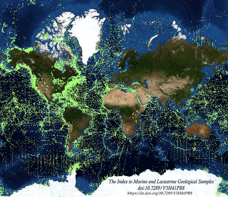