Marine Geology Reports in the NGDC Archive

browse graphicdata locations
Historic Marine Geologic data reports available are from academia, government, and non-U.S. sources. These reports were originally in paper or film form and were scanned to Portable Document Format (PDF) to enable online browse/download and archive in digital form. The following are examples of the types of analyses of sediment or rock from the ocean floor or lakebeds worldwide which may be included in individual data reports: descriptions of composition and/or lithology, grain size and other physical properties, mineralogy, geochemistry, paleontology, petrology, paleomagnetism and acoustics of sediment. They may also contain low-resolution photographs of cores or dredges, or the ocean floor. Reports are searchable via the Marine Geology Digital Inventory and may also be linked to/discoverable via the Index to Marine and Lacustrine Geological Samples (IMLGS). Scanned images of most paper data reports are available to view online, however, some Copyrighted reports contributed through the World Data Center System are available for on-site inspection only. For these reports, the geologic inventory provides links to the contributing institution for ordering.
  • Cite as: Multiple Investigators.1976: Marine Geology Reports in the NGDC Archive. NOAA National Centers for Environmental Information. Accessed [date].
  • NCEI Metadata ID: gov.noaa.ngdc.mgg.geology:G00502
gov.noaa.ngdc.mgg.geology:G00502
Search Data
  • ArcGIS map (search)
    ArcGIS interactive map interface to search and download data.
  • Web forms interface (search)
    Web forms interface to search and download data.
Distribution Formats
  • PDF
    • File Specification: Adobe Portable Document Format (PDF).
Ordering Instructions Contact NCEI for other distribution options and instructions.
Distributor NOAA National Centers for Environmental Information
ncei.info@noaa.gov
Dataset Point of Contact NOAA National Centers for Environmental Information
ncei.info@noaa.gov
Dataset Point of Contact Marine Geology Data Manager
NOAA National Centers for Environmental Information
geology.info@noaa.gov
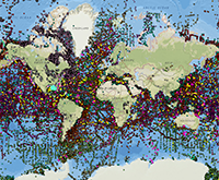
Coverage Description Global ocean floor
Time Period 1930-01-01 to 2013-11-26
Spatial Reference System urn:ogc:def:crs:EPSG:4326
Spatial Bounding Box Coordinates
West:-180.0
East:180.0
South:-90.0
North:90.0
Spatial Coverage Map
General Documentation
  • Metadata Landing Page
    Information about the data set, all access options, and complete documentation.
  • Web page
    Web page of information about the data set with links to download data and documentation from NCEI.
Associated Resources
Publication Dates
  • publication: 1976-01-01
  • revision: 2015-06-01
Data Presentation Form Digital image
Dataset Progress Status Complete - production of the data has been completed
Historical archive - data has been stored in an offline storage facility
Data Update Frequency Irregular - Additions as new reports are received.
Supplemental Information
Many data reports were received as paper copies, on 35-mm or 16-mm microfilm, or microfiche. All paper reports have been scanned to PDF and some microfilm reports are also available as PDF, however some reports are obtainable only offline in their original form.
Purpose Marine Geological and Geophysical Research and Environmental Studies
Use Limitations
  • Produced by the NOAA National Centers for Environmental Information. Not subject to copyright protection within the United States.
Dataset Citation
  • Cite as: Multiple Investigators.1976: Marine Geology Reports in the NGDC Archive. NOAA National Centers for Environmental Information. Accessed [date].
Cited Authors
  • Multiple Investigators
Publishers
  • NOAA National Centers for Environmental Information
Acknowledgments
  • Credit the source of the original data set.
Theme keywords Library of Congress Subject Headings
  • Scientific archives
  • Electronic records
  • Oceanography
  • Ocean bottom
  • Geology
  • Submarine geology
  • Marine sediments
SeaDataNet Common Vocabularies
  • Marine geology
USGS Science Topics
  • Sea-floor characteristics
Global Change Master Directory (GCMD) Science Keywords
  • Earth Science > Oceans > Marine Sediments > Geotechnical Properties
  • Earth Science > Oceans > Marine Sediments > Sediment Chemistry
  • Earth Science > Oceans > Marine Sediments > Sediment Composition
  • Earth Science > Oceans > Marine Sediments > Sedimentary Textures
  • Earth Science > Paleoclimate > Ocean/Lake Records > Boreholes
  • Earth Science > Paleoclimate > Ocean/Lake Records > Isotopes
  • Earth Science > Paleoclimate > Ocean/Lake Records > Microfossils
  • Earth Science > Paleoclimate > Ocean/Lake Records > Paleomagnetic Data
  • Earth Science > Paleoclimate > Ocean/Lake Records > Sediments
  • Earth Science > Solid Earth > Rocks/Minerals/Crystals > Major Elements
  • Earth Science > Solid Earth > Rocks/Minerals/Crystals > Minor Elements
  • Earth Science > Solid Earth > Rocks/Minerals/Crystals > Trace Elements
  • Earth Science > Solid Earth > Geomagnetism > Paleomagnetism
  • Earth Science > Solid Earth > Rocks/Minerals/Crystals > Age Determinations
  • Earth Science > Solid Earth > Rocks/Minerals/Crystals > Igneous Rocks
  • Earth Science > Solid Earth > Rocks/Minerals/Crystals > Metamorphic Rocks
  • Earth Science > Solid Earth > Rocks/Minerals/Crystals > Sedimentary Rocks
  • Earth Science > Solid Earth > Rocks/Minerals/Crystals > Sediments
  • Earth Science > OCEANS > Marine Sediments > Stratigraphic Sequence
  • Earth Science > PALEOCLIMATE > Ocean/Lake Records > Stratigraphic Sequence
Uncontrolled Keywords
  • Mineralogy
  • Paleontology
  • Geochemistry
  • Lithology
  • Petrology
  • Sea Floor Photographs
Global Change Master Directory (GCMD) Service Keywords
  • DATA ANALYSIS AND VISUALIZATION > GEOGRAPHIC INFORMATION SYSTEMS > WEB-BASED GEOGRAPHIC INFORMATION SYSTEMS
  • DATA MANAGEMENT/DATA HANDLING > DATA SEARCH AND RETRIEVAL
  • DATA ANALYSIS AND VISUALIZATION > VISUALIZATION/IMAGE PROCESSING
Data Center keywords Global Change Master Directory (GCMD) Data Center Keywords
  • DOC/NOAA/NESDIS/NCEI > National Centers for Environmental Information, NESDIS, NOAA, U.S. Department of Commerce
  • DOC/NOAA/NESDIS/NGDC > National Geophysical Data Center, NESDIS, NOAA, U.S. Department of Commerce
Platform keywords Global Change Master Directory (GCMD) Platform Keywords
  • In Situ Ocean-based Platforms > Ships
Instrument keywords Global Change Master Directory (GCMD) Instrument Keywords
  • In Situ/Laboratory Instruments > Corers > Coring Devices
  • In Situ/Laboratory Instruments > Samplers > Dredging Devices
  • In Situ/Laboratory Instruments > Samplers > Grabbers/Traps/Collectors > Grab Samplers
  • In Situ/Laboratory Instruments > Corers > ROCK CORERS
  • In Situ/Laboratory Instruments > Corers > Sediment Corers
Place keywords Global Change Master Directory (GCMD) Location Keywords
  • SOLID EARTH > CRUST
  • Geographic Region > Global Ocean
  • Vertical Location >Sea Floor
Project keywords Global Change Master Directory (GCMD) Project Keywords
  • Unknown
  • ICSU-WDS > International Council for Science - World Data System
Use Constraints
  • Use liability: NOAA and NCEI cannot provide any warranty as to the accuracy, reliability, or completeness of furnished data. Users assume responsibility to determine the usability of these data. The user is responsible for the results of any application of this data for other than its intended purpose.
  • While every effort has been made to ensure that these data are accurate and reliable within the limits of the current state of the art, NOAA cannot assume liability for any damages caused by any errors or omissions in the data, nor as a result of the failure of the data to function on a particular system. NOAA makes no warranty, expressed or implied, nor does the fact of distribution constitute such a warranty.
Access Constraints
  • Distribution liability: NOAA and NCEI make no warranty, expressed or implied, regarding these data, nor does the fact of distribution constitute such a warranty. NOAA and NCEI cannot assume liability for any damages caused by any errors or omissions in these data. If appropriate, NCEI can only certify that the data it distributes are an authentic copy of the records that were accepted for inclusion in the NCEI archives.
  • Access to this dataset is unrestricted.
Other Constraints Cite as: Multiple Investigators.1976: Marine Geology Reports in the NGDC Archive. NOAA National Centers for Environmental Information. Accessed [date].
Fees
  • In most cases, electronic downloads of the data are free. However, fees may apply for custom orders, data certifications, copies of analog materials, and data distribution on physical media.
Lineage information for:dataset
Lineage Statement lineage prior to transfer to NCEI is unknown.
Processing Environment Native Dataset Environment: ASCII text
Source Datasets
Lineage information for:repository
Processing Steps
  • 2015-04-22T00:00:00 -NOAA created the National Centers for Environmental Information (NCEI) by merging NOAA's National Climatic Data Center (NCDC), National Geophysical Data Center (NGDC), and National Oceanographic Data Center (NODC), including the National Coastal Data Development Center (NCDDC), per the Consolidated and Further Continuing Appropriations Act, 2015, Public Law 113-235. NCEI launched publicly on April 22, 2015.
Acquisition Information (collection)
Instrument
  • In Situ/Laboratory Instruments
Platform
  • In Situ Ocean-based Platforms > SHIPS
Last Modified: 2020-04-21
For questions about the information on this page, please email:ncei.info@noaa.gov