CLIMAP 120K bp Sediment Data Files - Micropaleontology, Carbonate Percentages, Carbon 14 Age Dates, and Oxygen Isotope Data for 52 Selected Seafloor Cores

browse graphic
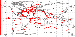
sample locations in study area
The CLIMAP (Climate: Long-range Investigation, Mapping, and Prediction) Project was funded by the National Science Foundation as part of the International Decade of Ocean Exploration (IDOE). Collection and analysis of cores for the 120K bp CLIMAP set was carried out by several institutions; data were compiled by the Lamont-Doherty Earth Observatory of Columbia University. Data include micropaleontology, carbonate percentages, carbon 14 age dates, sea surface temperature estimates, and oxygen and carbon isotopic data for 52 ocean sediment cores. Data cover the period from 140,000 to 100,000 years before present and are global in extent. The CLIMAP 120k data are available for direct download via NCDC's Web server. The CLIMAP 120k data set was originally submitted to NOAA's National Geophysical Data Center (NGDC) for archive, but was subsequently transferred to NOAA's National Climatic Data Center (NCDC) Paleoclimatology Group for stewardship.
  • Cite as: Lamont-Doherty Earth Observatory (LDEO). 1981: CLIMAP 120K bp Sediment Data Files - Micropaleontology, Carbonate Percentages, Carbon 14 Age Dates, and Oxygen Isotope Data for 52 Selected Seafloor Cores. NOAA National Centers for Environmental Information. Accessed [date].
  • ID not available.
gov.noaa.ngdc.mgg.geology:G00995
Download Data
  • Data files and documentation (download)
    Web page of information about the database including links to full documentation and free data download.
Distribution Formats
  • ASCII
Ordering Instructions Contact NCEI for other distribution options and instructions.
Distributor NOAA National Centers for Environmental Information
ncei.info@noaa.gov
Dataset Point of Contact NOAA National Centers for Environmental Information
ncei.info@noaa.gov
Dataset Point of Contact Marine Geology Data Manager
NOAA National Centers for Environmental Information
geology.info@noaa.gov
Coverage Description Global ocean
Time Period 1980-08-31 to 1980-08-31
Spatial Reference System urn:ogc:def:crs:EPSG:4326
Spatial Bounding Box Coordinates
West:-162.883
East:163.033
South:-64.85
North:82.933
Spatial Coverage Map
General Documentation
  • Publisher's landing page
    Web page of information about the database including links to full documentation and free data download.
Associated Resources
Publication Dates
  • publication: 1981-12-31
  • revision: 1981-12-31
Edition First
Data Presentation Form Digital table - digital representation of facts or figures systematically displayed, especially in columns
Dataset Progress Status Complete - production of the data has been completed
Historical archive - data has been stored in an offline storage facility
Data Update Frequency Not planned - Completed data set, no additions planned.
Supplemental Information
Also distributed through the World Data Center for Paleoclimatology
Purpose Paleoceanographic Research
Use Limitations
  • Produced by the NOAA National Centers for Environmental Information. Not subject to copyright protection within the United States.
Dataset Citation
  • Cite as: Lamont-Doherty Earth Observatory (LDEO). 1981: CLIMAP 120K bp Sediment Data Files - Micropaleontology, Carbonate Percentages, Carbon 14 Age Dates, and Oxygen Isotope Data for 52 Selected Seafloor Cores. NOAA National Centers for Environmental Information. Accessed [date].
Cited Authors
  • Lamont-Doherty Earth Observatory (LDEO)
Publishers
  • NOAA National Centers for Environmental Information
Acknowledgments
  • CLIMAP research team, Lamont-Doherty Earth Observatory of Columbia University, and the US National Science Foundation
Theme keywords Library of Congress Subject Headings
  • Scientific archives
  • Electronic records
  • Oceanography
  • Ocean bottom
  • Geology
  • Submarine geology
  • Marine sediments
SeaDataNet Common Vocabularies
  • Marine geology
USGS Science Topics
  • Sea-floor characteristics
Global Change Master Directory (GCMD) Science Keywords
  • EARTH SCIENCE > Oceans > Marine Sediments > Sediment Chemistry
  • EARTH SCIENCE > Oceans > Marine Sediments > Sediment Composition
  • EARTH SCIENCE > Paleoclimate > Ocean/Lake Records > Isotopes
  • EARTH SCIENCE > Paleoclimate > Ocean/Lake Records > Oxygen Isotopes
  • EARTH SCIENCE > Paleoclimate > Ocean/Lake Records > Microfossils
  • EARTH SCIENCE > PALEOCLIMATE > Ocean/Lake Records > Isotopes
  • EARTH SCIENCE > PALEOCLIMATE > Ocean/Lake Records > Microfossils
  • EARTH SCIENCE > PALEOCLIMATE > Ocean/Lake Records > Oxygen Isotopes
  • EARTH SCIENCE > PALEOCLIMATE > Ocean/Lake Records > Sediments
  • EARTH SCIENCE > PALEOCLIMATE > Ocean/Lake Records > Radiocarbon
Data Center keywords Global Change Master Directory (GCMD) Data Center Keywords
  • WDC/PALEOCLIMATOLOGY, BOULDER > World Data Center for Paleoclimatology, Boulder
  • DOC/NOAA/NESDIS/NCEI > National Centers for Environmental Information, NESDIS, NOAA, U.S. Department of Commerce
  • DOC/NOAA/NESDIS/NGDC > National Geophysical Data Center, NESDIS, NOAA, U.S. Department of Commerce
Platform keywords Global Change Master Directory (GCMD) Platform Keywords
  • In Situ Ocean-based Platforms > SHIPS
Instrument keywords Global Change Master Directory (GCMD) Instrument Keywords
  • In Situ/Laboratory Instruments > Corers > CORING DEVICES
  • In Situ/Laboratory Instruments > Corers > SEDIMENT CORERS
Place keywords Global Change Master Directory (GCMD) Location Keywords
  • GEOGRAPHIC REGION > GLOBAL OCEAN
  • VERTICAL LOCATION > SEA FLOOR
Project keywords Global Change Master Directory (GCMD) Project Keywords
  • CLIMAP > Climate - Long Range Investigation, Mapping and Prediction
  • ICSU-WDS > International Council for Science - World Data System
Use Constraints
  • Use liability: NOAA and NCEI cannot provide any warranty as to the accuracy, reliability, or completeness of furnished data. Users assume responsibility to determine the usability of these data. The user is responsible for the results of any application of this data for other than its intended purpose.
  • While every effort has been made to ensure that these data are accurate and reliable within the limits of the current state of the art, NOAA cannot assume liability for any damages caused by any errors or omissions in the data, nor as a result of the failure of the data to function on a particular system. NOAA makes no warranty, expressed or implied, nor does the fact of distribution constitute such a warranty.
Access Constraints
  • Distribution liability: NOAA and NCEI make no warranty, expressed or implied, regarding these data, nor does the fact of distribution constitute such a warranty. NOAA and NCEI cannot assume liability for any damages caused by any errors or omissions in these data. If appropriate, NCEI can only certify that the data it distributes are an authentic copy of the records that were accepted for inclusion in the NCEI archives.
  • Access to this dataset is unrestricted.
Other Constraints Cite as: Lamont-Doherty Earth Observatory (LDEO). 1981: CLIMAP 120K bp Sediment Data Files - Micropaleontology, Carbonate Percentages, Carbon 14 Age Dates, and Oxygen Isotope Data for 52 Selected Seafloor Cores. NOAA National Centers for Environmental Information. Accessed [date].
Fees
  • In most cases, electronic downloads of the data are free. However, fees may apply for custom orders, data certifications, copies of analog materials, and data distribution on physical media.
Lineage information for:dataset
Lineage Statement Data originally submitted to NOAA's former National Geophysical Data Center (NGDC) then transferred to the former National Climatic Data Center (NCDC) Paleoclimatology for stewardship, both centers are now part of NOAA's National Centers for Environmental Information (NCEI). Processing and lineage prior to transmission to NGDC are unknown.
Processing Environment Native Dataset Environment: ASCII text
Source Datasets
Lineage information for:repository
Processing Steps
  • 2015-04-22T00:00:00 -NOAA created the National Centers for Environmental Information (NCEI) by merging NOAA's National Climatic Data Center (NCDC), National Geophysical Data Center (NGDC), and National Oceanographic Data Center (NODC), including the National Coastal Data Development Center (NCDDC), per the Consolidated and Further Continuing Appropriations Act, 2015, Public Law 113-235. NCEI launched publicly on April 22, 2015.
Acquisition Information (collection)
Instrument
  • In Situ/Laboratory Instruments
Platform
  • In Situ Ocean-based Platforms > SHIPS
Last Modified: 2020-04-21
For questions about the information on this page, please email:ncei.info@noaa.gov