|
Downward-continued gravity, RMS gravity roughness and residual roughness of the world's ocean crustPlease cite the source when using these data: Whittaker, J.M., Müller, R.D., Roest, W.R., Wessel, P., and Smith, W.H.F., 2008, How supercontinents and superoceans affect seafloor roughness: Nature, 456, p. 938-941, (18 December 2008) doi:10.1038/nature07573
The authors present three companion digital grids of the downward-continued gravity, RMS gravity roughness, and residual roughness of the world's ocean basins as geographic and Mercator grids with 2 minute resolution. Non-spreading ridge related bathymetry has been masked, namely continental shelves, Large Igneous Provinces and seamounts, in the roughness and residual roughness datasets. We use a global grid of gravity anomalies based on satellite altimetry, downward continued and draped onto the lowpass of the topo_8.2.img grid of the sea floor using the filters to create a global grid of oceanic basement roughness. Our roughness filter is a variable-width Gaussian filter adjusted to the local scale of the Mercator-projected data, whose half-power point wavelength is 50 km, reflecting gravity anomalies due to uncompensated basement topography, implemented in the Generic Mapping Tools program grdfilter. This weighted-average filter is applied to individual points to compute r.m.s. marine gravity roughness. Short-wavelength roughness in gravity anomalies (20-160-km wavelength) reflects the roughness of oceanic basement topography. The 100 km filter width was compared with a 160 km filter width, but the latter resulted in a grid where many basement tectonic features were not well resolved. This reflects the fact that the vast majority of structural features of the sea floor such as abyssal hills, fracture zone troughs and ridges have wavelengths significantly smaller than 160 km. The RMS residual roughness grid has had roughness attributable to spreading rates and sediment cover. Analysis of the relationship between gravity-derived roughness and spreading rate and sediment thickness was conducted using global grids of sediment thickness, half-spreading rates and oceanic basement roughness. The linear relationships between spreading rate and sediment thickness and gravity-derived roughness were used to create a predicted roughness grid, which was then subtracted from the r.m.s. gravity-derived roughness grid. |
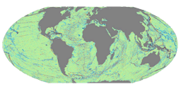
Downward Continued Gravity 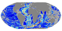
Gravity Roughness 
Gravity Residual Roughness
Global Grids:
2008 Age Grid ETOPO1 Global Relief GLOBE Topography Ocean Sediment Thickness Related Data at NCEI: Bathymetry & Relief Geomagnetism Marine Geology & Geophysics Related Data at EarthByte: 2008 Age Grid Reconstructed paleo-age grids EarthByte Resources Page |
 |
|
| All MGG Data | All Marine Geophysics | Bathymetry | Seismic Reflection | Trackline Geophysical Data Viewer |