LDEO Carbonate Data - CaCO3 Percentages for 328 Sediments Cores, Principally from The Atlantic Ocean Spanning 100,000 to 200,000 Years bp
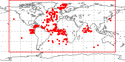 sample locations in study area
LDEO Carbonate data were compiled under the direction of A. Esmay and W.F. Ruddiman
at the Lamont-Doherty Earth Observatory of Columbia University. Data include CaCO3
percentages by interval down core for 328 sediments cores, principally from the Atlantic
ocean. Data are derived primarily from two sources. First, cores analyzed during the
CLIMAP project to generate stratigraphic control on cores from key deep-sea regions.
Second, cores analyzed using almost entirely National Science Foundation funds, but
through smaller grants to individuals and institutions. On average, cores span intervals
of time of 100,000 to 200,000 years and have been analyzed at time steps of a few
thousand years. Several cores span only the last deglaciation; a few cores cover much
longer intervals, up to 3 million years. Samples are annotated as either bulk sediment,
or fine-fraction. Data are available for free download. Data were originally submitted
to NOAA's National Geophysical Data Center (NGDC) for archive and were subsequently
transferred to NOAA's National Climatic Data Center (NCDC) Paleoclimatology Group
for stewardship.
- Cite as: Ruddiman, William F. and Ann Esmay. 1989: LDEO Carbonate Data - CaCO3 Percentages for 328 Sediments Cores, Principally from The Atlantic Ocean Spanning 100,000 to 200,000 Years bp. First. NOAA National Centers for Environmental Information. Accessed [date].
- ID not available.
gov.noaa.ngdc.mgg.geology:G00998
| Download Data |
|
| Distribution Formats |
|
| Ordering Instructions | Contact NCEI for other distribution options and instructions. |
| Distributor | NOAA National Centers for Environmental Information ncei.info@noaa.gov |
| Dataset Point of Contact | NOAA National Centers for Environmental Information ncei.info@noaa.gov |
| Dataset Point of Contact | Marine Geology Data Manager NOAA National Centers for Environmental Information geology.info@noaa.gov |
| Coverage Description | Global sea floor |
| Time Period | 1989-12-31 to 1989-12-31 |
| Spatial Reference System | urn:ogc:def:crs:EPSG:4326 |
| Spatial Bounding Box Coordinates |
West:-140.85
East:137.767
South:-46.05
North:78.9
|
| Spatial Coverage Map | |
| General Documentation |
|
| Associated Resources |
|
| Publication Dates |
|
| Edition | First |
| Data Presentation Form | Digital table - digital representation of facts or figures systematically displayed,
especially in columns |
| Dataset Progress Status | Complete - production of the data has been completed Historical archive - data has been stored in an offline storage facility |
| Data Update Frequency | Not planned - Completed data set, no additions planned. |
| Supplemental Information |
Also distributed by the World Data Center for Paleoclimatology
|
| Purpose | Paleoceanographic Research |
| Use Limitations |
|
| Dataset Citation |
|
| Cited Authors |
|
| Publishers |
|
| Acknowledgments |
|
| Theme keywords | Library of Congress Subject Headings
|
| Data Center keywords | Global Change Master Directory (GCMD) Data Center Keywords
|
| Platform keywords | Global Change Master Directory (GCMD) Platform Keywords
|
| Instrument keywords | Global Change Master Directory (GCMD) Instrument Keywords
|
| Place keywords | Global Change Master Directory (GCMD) Location Keywords
|
| Project keywords | Global Change Master Directory (GCMD) Project Keywords
|
| Use Constraints |
|
| Access Constraints |
|
| Other Constraints | Cite as: Ruddiman, William F. and Ann Esmay. 1989: LDEO Carbonate Data - CaCO3 Percentages for 328 Sediments Cores, Principally from The Atlantic Ocean Spanning 100,000 to 200,000 Years bp. First. NOAA National Centers for Environmental Information. Accessed [date]. |
| Fees |
|
| Lineage Statement | Data originally submitted to NOAA's former National Geophysical Data Center (NGDC) then transferred to the former National Climatic Data Center (NCDC) Paleoclimatology for stewardship, both centers are now part of NOAA's National Centers for Environmental Information (NCEI). Processing and lineage prior to transmission to NGDC are unknown. |
| Processing Environment | Native Dataset Environment: ASCII text |
| Source Datasets |
| Processing Steps |
|
| Instrument |
|
| Platform |
|
Last Modified: 2020-04-21
For questions about the information on this page, please email:ncei.info@noaa.gov