Archive of Geosample Information from the Geological Survey of Canada (GSC) Marine Geoscience Collection (GSC Atlantic and GSC Pacific)

browse graphic
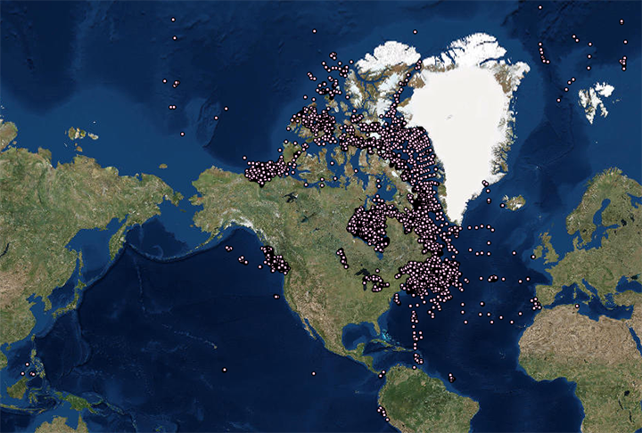
image of sea floor sample locations
The Geological Survey of Canada (GSC) Marine Geoscience Collection (GSC Atlantic and GSC Pacific) contributed information on 40,428 cores, grabs, and dredges in their holdings to the Index to Marine and Lacustrine Geological Samples (IMLGS) database. Only metadata describing the GSC A samples is maintained in the IMLGS for search purposes, no additional data are archived at NCEI. Complete data and information are available from the contributing institution.
  • Cite as: Geological Survey of Canada (GSC) Marine Geoscience Collection (GSC Atlantic and GSC Pacific). 1998: Archive of information about the National Marine Geoscience Collection of Canada. NOAA National Centers for Environmental Information. https://doi.org/doi:10.7289/V5H70CS1 [date of access].
  • doi:10.7289/V5H70CS1
  • NCEI Metadata ID: gov.noaa.ngdc.mgg.geology:archived-data_Canada-sample-repository
gov.noaa.ngdc.mgg.geology:archived-data_Canada-sample-repository
Search Data
  • Map viewer (search)
    Open an ArcGIS interactive map interface with the GSC sample layer active, to search and download data from the IMLGS database and access related links.
  • The new IMLGS web application (search)
    The new IMLGS web application (2021), which uses a new REST-style API, provides a user interface for querying and displaying the IMLGS data.
  • NOAA GeoPlatform (search)
    Access sample information from the IMLGS using the NOAA GeoPlatform.
Download Data
  • Table View (download)
    A table view for searching and exporting data for GSC samples from the IMLGS database and accessing related links.
Distribution Formats
  • ASCII (Version:UTF-8)
    • File Specification: American Standard Code for Information Interchange (ASCII) text format.
Ordering Instructions Contact NCEI for other distribution options and instructions.
Distributor NOAA National Centers for Environmental Information
ncei.info@noaa.gov
Dataset Point of Contact NOAA National Centers for Environmental Information
ncei.info@noaa.gov
Dataset Point of Contact Marine Geology Data Manager
NOAA National Centers for Environmental Information
geology.info@noaa.gov
Dataset Point of Contact National Marine Geoscience Collection
Geological Survey of Canada (GSC) Marine Geoscience Collection (GSC Atlantic and GSC Pacific)
kate.jarrett@nrcan-rncan.gc.ca
Coverage Description Global lakebeds
Time Period 1950-01-01T00:00:00.000Z to 2007-03-31T00:00:00.000Z
Spatial Reference System urn:ogc:def:crs:EPSG:4326
Spatial Bounding Box Coordinates
West:-178.6675
East:174.6583
South:-13.1468
North:89.9833
Spatial Coverage Map
General Documentation
  • Metadata Landing Page
    How to cite this data set (doi:10.7289/V5H70CS1), all access options, and complete documentation.
  • Originator's Web Page
    Expedition Database: Information (metadata) and data related to marine and coastal field surveys
  • Originator's Web Page
    GeoCollections: Offshore and Coastal Canadian Samples and Geophysical Records Holdings
  • Originator's Web Page
    BASIN Database: Geological, geophysical and engineering information related to petroleum exploration
  • Archived Files
    Related offline geosample data files in the NCEI long-term archive
Associated Resources
  • Geological Survey of Canada (GSC) Marine Geoscience Collection (GSC Atlantic and GSC Pacific)
  • Index to Marine and Lacustrine Geological Samples (IMLGS)
  • NCEI Marine Geology Data Archive
    • Parent Archive
      Information about the Marine Geology Data Archive at NCEI
  • NOAA/NCEI Marine Geology WAF
Publication Dates
  • publication: 1998-01-01
  • revision: 2022-04-22
Data Presentation Form Digital table - digital representation of facts or figures systematically displayed, especially in columns
Dataset Progress Status Complete - production of the data has been completed
Historical archive - data has been stored in an offline storage facility
Data Update Frequency Not planned - The Geological Survey of Canada (GSC) Marine Geoscience Collection (GSC Atlantic and GSC Pacific) is in the process of revising all entries in the IMLGS describing the National Marine Geoscience Collection of Canada. Revised data are expected to be contributed to the IMLGS database.
Supplemental Information
Additonal related data and information are available directly from the contributing institution, which is the authoritative and most current source of data and information related to their sample collection. The IMLGS contains a subset of summary metadata from the institutional database. Only a portion of the Canadian National Marine Geoscience collection is described in the IMLGS. Data may not match more current information at GSC A. Revised data are in preparation by the Curator.
Purpose The purpose of adding information about the National Marine Geoscience Collection of Canada to the IMLGS was to promote new research on existing samples.
Use Limitations
  • Produced by the NOAA National Centers for Environmental Information. Not subject to copyright protection within the United States.
Dataset Citation
  • Cite as: Geological Survey of Canada (GSC) Marine Geoscience Collection (GSC Atlantic and GSC Pacific). 1998: Archive of information about the National Marine Geoscience Collection of Canada. NOAA National Centers for Environmental Information. https://doi.org/doi:10.7289/V5H70CS1 [date of access].
Cited Authors
  • Geological Survey of Canada (GSC) Marine Geoscience Collection (GSC Atlantic and GSC Pacific)
Originators
  • Kate Jarrett, Curator
    Geological Survey of Canada, Atlantic (GSC Atlantic )
  • Dr. Iris Hardy, former Curator
    Geological Survey of Canada, Atlantic (GSC Atlantic )
Custodians
  • NOAA National Centers for Environmental Information
Publishers
  • NOAA National Centers for Environmental Information
Acknowledgments
  • More complete data about this sample collection is maintained by the contributing institution.
Theme keywords Library of Congress Subject Headings
  • Databases
  • Scientific archives
  • Electronic records
  • Oceanography
  • Ocean bottom
  • Geology
  • Submarine geology
  • Marine sediments
SeaDataNet Common Vocabularies
  • Marine geology
  • Rock and sediment lithology and mineralogy
USGS Science Topics
  • Sea-floor characteristics
USDA National Agricultural Library's Agricultural Thesaurus (NALT)
  • lacustrine sediments
Global Change Master Directory (GCMD) Science Keywords
  • Earth Science > Oceans > Marine Sediments
  • Earth Science > Oceans > Marine Sediments > Sediment Composition
  • Earth Science > Paleoclimate > Ocean/Lake Records > Sediments
Data Center keywords Global Change Master Directory (GCMD) Data Center Keywords
  • DOC/NOAA/NESDIS/NCEI > National Centers for Environmental Information, NESDIS, NOAA, U.S. Department of Commerce
  • DOC/NOAA/NESDIS/NGDC > National Geophysical Data Center, NESDIS, NOAA, U.S. Department of Commerce
Platform keywords Global Change Master Directory (GCMD) Platform Keywords
  • In Situ Ocean-based Platforms > Ships
Instrument keywords Global Change Master Directory (GCMD) Instrument Keywords
  • In Situ/Laboratory Instruments > Corers > Coring Devices
  • In Situ/Laboratory Instruments > Samplers > Dredging Devices
  • In Situ/Laboratory Instruments > Samplers > Grabbers/Traps/Collectors > Grab Samplers
  • In Situ/Laboratory Instruments > Corers > Sediment Corers
  • In Situ/Laboratory Instruments > Corers > Box Core
  • In Situ/Laboratory Instruments > Corers > Gravity Corer
Place keywords Global Change Master Directory (GCMD) Location Keywords
  • Geographic Region > Global Ocean
  • Vertical Location > Sea Floor
  • Ocean > Arctic Ocean
  • Ocean > Atlantic Ocean
  • Ocean > Pacific Ocean
Project keywords Global Change Master Directory (GCMD) Project Keywords
  • IMLGS > Index to Marine and Lacustrine Geological Samples
Global Change Master Directory (GCMD) Project Keywords
  • ICSU-WDS > International Council for Science - World Data System
Use Constraints
  • Use liability: NOAA and NCEI cannot provide any warranty as to the accuracy, reliability, or completeness of furnished data. Users assume responsibility to determine the usability of these data. The user is responsible for the results of any application of this data for other than its intended purpose.
  • Please consult the Curator before proposing to do research on any sample discovered through the IMLGS or the NCEI archive.
  • While every effort has been made to ensure that these data are accurate and reliable within the limits of the current state of the art, NOAA cannot assume liability for any damages caused by any errors or omissions in the data, nor as a result of the failure of the data to function on a particular system. NOAA makes no warranty, expressed or implied, nor does the fact of distribution constitute such a warranty.
Access Constraints
  • Distribution liability: NOAA and NCEI make no warranty, expressed or implied, regarding these data, nor does the fact of distribution constitute such a warranty. NOAA and NCEI cannot assume liability for any damages caused by any errors or omissions in these data. If appropriate, NCEI can only certify that the data it distributes are an authentic copy of the records that were accepted for inclusion in the NCEI archives.
  • Sample metadata are available online for free download.
Other Constraints Cite as: Geological Survey of Canada (GSC) Marine Geoscience Collection (GSC Atlantic and GSC Pacific). 1998: Archive of information about the National Marine Geoscience Collection of Canada. NOAA National Centers for Environmental Information. https://doi.org/doi:10.7289/V5H70CS1 [date of access].
Fees
  • In most cases, electronic downloads of the data are free. However, fees may apply for custom orders, data certifications, copies of analog materials, and data distribution on physical media.
Lineage information for:dataset
Lineage Statement Data are received by NCEI on an intermittent basis from the repository. Incoming data are checked for adherence to controlled vocabularies, illegal data types in numeric fields, and out of range latitudes/longitudes. NCEI adds IGSNs/links to related resources, where known, and may perform cursory visual inspection of data for reasonableness, asking the originator for guidance on discrepancies. NCEI informs the originator upon ingest of data to the IMLGS database, after which the originator provides one final quality control using the IMLGS map viewer. Data may also be updated/corrected at any time, at the originator's request.
Processor
  • NOAA National Centers for Environmental Information
  • NOAA National Centers for Environmental Information / Northern Gulf Institute
Processing Environment Native Dataset Environment: database tables
Source Datasets
  • Geological Survey of Canada (GSC) Marine Geoscience Collection (GSC Atlantic and GSC Pacific) database, reports, and publications
    • Description of Source: Additonal related data and information are available directly from the contributing institution, which is the authoritative and most current source of data and information related to their sample collection. The IMLGS contains a subset of summary metadata from the institutional database.
Lineage information for:repository
Processing Steps
  • 2015-04-22T00:00:00 -NOAA created the National Centers for Environmental Information (NCEI) by merging NOAA's National Climatic Data Center (NCDC), National Geophysical Data Center (NGDC), and National Oceanographic Data Center (NODC), including the National Coastal Data Development Center (NCDDC), per the Consolidated and Further Continuing Appropriations Act, 2015, Public Law 113-235. NCEI launched publicly on April 22, 2015.
Acquisition Information (collection)
Instrument
  • In Situ/Laboratory Instruments
Platform
  • In Situ Ocean-based Platforms > SHIPS
Last Modified: 2022-04-22
For questions about the information on this page, please email:ncei.info@noaa.gov