EMAG2v3: Earth Magnetic Anomaly Grid (2-arc-minute resolution)
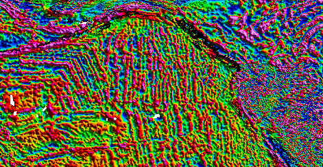 EMAG2v3 showing the west coast of the United States and Canada. The stripes are magnetic
lineations due to sea-floor spreading.
EMAG2v3 showing the west coast of the United States and Canada. The stripes are magnetic
lineations due to sea-floor spreading.EMAG2v3 is a global Earth Magnetic Anomaly Grid compiled from satellite, ship, and
airborne magnetic measurements. It is a significant update of the previous release
of the Earth Magnetic Anomaly Grid. The resolution remains 2 arc-minutes, and the
altitude of 4 km above the geoid is still supported, but an additional product, a
grid that is observed at sea-level over oceanic regions, has been produced. New additions
grid and track line data have been included, both over land and the oceans. Wherever
available, the original shipborne and airborne data were used instead of precompiled
oceanic magnetic grids. Interpolation between sparse track lines in the oceans was
improved by using a kriging algorithm, which specializes in heterogeneous data distribution
gridding, in order to create a compilation as true to the observed data as possible,
and avoid using a priori information. The longest wavelengths (>300 km) were replaced
with the latests satellite lithosphere magnetic field model, MF7.
- Cite as: Brian Meyer; Richard Saltus; and Arnaud Chulliat. 2017: EMAG2v3: Earth Magnetic Anomaly Grid (2-arc-minute resolution). Version 3. NOAA National Centers for Environmental Information. https://doi.org/10.7289/V5H70CVX. Accessed [date].
- doi:10.7289/V5H70CVX
- NCEI Metadata ID: gov.noaa.ngdc.mgg.geophysical_models:EMAG2_V3
gov.noaa.ngdc.mgg.geophysical_models:EMAG2_V3
| Download Data |
|
| Distribution Formats |
|
| Ordering Instructions | Contact NCEI for other distribution options and instructions. |
| Distributor | NOAA National Centers for Environmental Information ncei.info@noaa.gov |
| Dataset Point of Contact | NOAA National Centers for Environmental Information ncei.info@noaa.gov |
| Dataset Point of Contact | NCEI Geomagnetic Modeling Team NOAA National Centers for Environmental Information geomag.models@noaa.gov |
| Time Period | 1946-01-01 to 2014-02-20 |
| Spatial Reference System | urn:ogc:def:crs:EPSG::4326 |
| Spatial Bounding Box Coordinates |
West:0
East:360
South:-90
North:90
|
| Spatial Coverage Map | |
| General Documentation | |
| Associated Resources |
|
| Publication Dates |
|
| Edition | Version 3 |
| Data Presentation Form | mapDigital |
| Dataset Progress Status | Complete - production of the data has been completed Historical archive - data has been stored in an offline storage facility |
| Data Update Frequency | As needed |
| Purpose | Magnetic anomaly maps provide insight into the subsurface structure and composition of the Earth's crust. Over continental areas, magnetic anomalies illuminate geologic, tectonic, and geothermal evolution of crust and lithosphere. In the world's oceans, anomalies trending parallel to the isochrons (lines of equal age) reveal the temporal evolution of oceanic crust. Magnetic maps are widely used in the geological sciences and in resource exploration. |
| Use Limitations |
|
| Dataset Citation |
|
| Cited Authors |
|
| Originators |
|
| Publishers |
|
| Theme keywords | Global Change Master Directory (GCMD) Science Keywords
|
| Data Center keywords | Global Change Master Directory (GCMD) Data Center Keywords
|
| Place keywords | Global Change Master Directory (GCMD) Location Keywords
|
| Use Constraints |
|
| Access Constraints |
|
| Other Constraints | Cite as: Brian Meyer; Richard Saltus; and Arnaud Chulliat. 2017: EMAG2v3: Earth Magnetic Anomaly Grid (2-arc-minute resolution). Version 3. NOAA National Centers for Environmental Information. https://doi.org/10.7289/V5H70CVX. Accessed [date]. |
| Fees |
|
| Processing Steps |
|
| Processing Steps |
|
Last Modified: 2020-05-14
For questions about the information on this page, please email:ncei.info@noaa.gov