 |
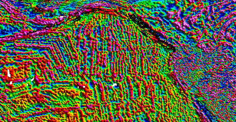
EMAG2v3 is a global Earth Magnetic Anomaly Grid compiled from satellite, ship, and
airborne magnetic measurements. It is a significant update of the previous release
of the Earth Magnetic Anomaly Grid. The resolution remains 2 arc-minutes, and the
altitude of 4 km above the geoid is still supported, but an additional product, a
grid that is observed at sea-level over oceanic regions, has been produced. New additions
grid and track line data have been included, both over land and the oceans. Wherever
available, the original shipborne and airborne data were used instead of precompiled
oceanic magnetic grids. Interpolation between sparse track lines in the oceans was
improved by using a kriging algorithm, which specializes in heterogeneous data distribution
gridding, in order to create a compilation as true to the observed data as possible,
and avoid using a priori information. The longest wavelengths (>300 km) were replaced
with the latests satellite lithosphere magnetic field model, MF7. |
 for EMAG2v3, where the altitude is at a consistent 4km altitude, with a resolution of 2 arc-minutes, which can be opened by ESRI ArcGIS or any other GIS application. The values (nT) are stored as 32-bit floating point.<br/><br/><a href="https://www.ngdc.noaa.gov/geomag/data/EMAG2/EMAG2_V3_20170530/EMAG2_V3_20170530_Sealevel.tif">Sea Level GIS TIFF</a><br/>A georeferenced TIFF (GeoTIFF) for EMAG2v3, where the altitude is at sea level over oceanic regions, with a resolution of 2 arc-minutes, which can be opened by ESRI ArcGIS or any other GIS application. The values (nT) are stored as 32-bit floating point.<br/><br/><a href="https://www.ngdc.noaa.gov/geomag/data/EMAG2/EMAG2_V3_20170530/EMAG2_V3_20170530_Code_map.png">Map of Source Grid Codes</a><br/>PNG of EMAG2v3 codes to designate which grid is primarily responsible for the anomaly value for each cell.<br/><br/><a href="https://www.ngdc.noaa.gov/geomag/data/EMAG2/EMAG2_V3_20170530/EMAG2_V3_20170530_Error_map.png">Map of Estimated Error Values</a><br/>PNG of EMAG2v3 estimates of the error in nanoTesla for each cell.<br/><br/></td> </tr><tr> <th>Data Formats</th> <td> <dl><dt>XYZ/Zip</dt><dd> Version:Version 3</dd><dd> Format Specification:Comma delimited ASCII grid that contains i and j grid indicies, latitude and longitude cell centered location information, magnetic anomalies at a consistent 4km elevation, magnetic anomalies at sea level over oceanic regions, anomaly source grid code, and an error estimate for each cell.</dd><br/><dt>ASCII TXT</dt><dd> Version:Version 3</dd><dd> Format Specification:An ASCII text file which describes the format of the CSV data grid.</dd><br/><dt>PNG</dt><dd> Version:Version 3</dd><dd> Format Specification:Full Resolution Map of EMAG2v3 as a poster at a consistent 4km altitude</dd><br/><dt>PNG</dt><dd> Version:Version 3</dd><dd> Format Specification:Full Resolution Map of EMAG2v3 as a poster at sea level over oceanic regions</dd><br/><dt>KMZ</dt><dd> Version:Version 3</dd><dd> Format Specification:Plugin for Google Earth of EMAG2v3 as a poster at a consistent 4km altitude with data gaps filled with MF7. Requires installation of Google Earth.</dd><br/><dt>GIS TIFF</dt><dd> Version:Version 3</dd><dd> Format Specification:A georeferenced TIFF (GeoTIFF) for EMAG2v3, where the altitude is 4km altitude above continental regions and sea level over oceanic regions, with a resolution of 2 arc-minutes, which can be opened by ESRI ArcGIS or any other GIS application. The values (nT) are stored as 32-bit floating point.</dd><br/><dt>PNG</dt><dd> Version:Version 3</dd><dd> Format Specification:Full Resolution Map of EMAG2v3 codes to designate which grid is primarily responsible for the anomaly value for each cell</dd><br/><dt>PNG</dt><dd> Version:Version 3</dd><dd> Format Specification:Full Resolution Map of EMAG2v3 estimates of the error in nanoTesla for each cell</dd><br/></dl> </td> </tr><tr> <th>Order Details</th> <td><b>Cost: </b>In most cases, electronic downloads of the data are free. However, fees may apply for custom orders, data certifications, copies of analog materials, and data distribution on physical media.<br/><b>Instructions: </b>Contact NCEI for other distribution options and instructions.</td> </tr></table></td> </tr> </table>'))
 Keywords</a><br/>The information provided on this page seeks to define how the GCMD Keywords are structured, used and accessed. It also provides information on how users can participate in the further development of the keywords.<br/><br/><a href="https://www.ncei.noaa.gov/contact">NCEI Contact Information</a><br/>Information for contacts at NCEI.<br/><br/><a href="https://www.ncei.noaa.gov/metadata/geoportal/rest/metadata/item/gov.noaa.ngdc.mgg.geophysical_models:EMAG2_V3/html">Metadata Landing Page</a><br/><br/><br/><a href="http://www.ngdc.noaa.gov/geomag/emag2.html">Home Page</a><br/><br/><br/></td> </tr><tr> <th>Search</th> <td><a href="https://epsg.org/home.html">European Petroleum Survey Group Geodetic Parameter Registry</a><br/>Registry that accesses the EPSG Geodetic Parameter Dataset, which is a structured dataset of Coordinate Reference Systems and Coordinate Transformations.<br/><br/></td> </tr><tr> <th>Download</th> <td><a href="https://www.ngdc.noaa.gov/geomag/data/EMAG2/EMAG2_V3_20170530/EMAG2_V3_20170530.zip">EMAG2v3 ASCII CSV data file</a><br/>Zip file containing the comma delimited ASCII grid that contains i and j grid indicies, latitude and longitude cell centered location information, magnetic anomalies at a consistent 4km elevation, sea level over oceanic regions, anomaly source grid code, and an error estimate for each cell.<br/><br/><a href="https://www.ngdc.noaa.gov/geomag/data/EMAG2/EMAG2_V3_20170530/EMAG2_readme.txt">EMAG2v3 Format Description</a><br/>ASCII text file that contains format description of the EMAG2v3 CSV data file.<br/><br/><a href="https://www.ngdc.noaa.gov/geomag/data/EMAG2/EMAG2_V3_20170530/EMAG2_V3_20170530_UpCont_poster.png">EMAG2v3 Full Resolution Map of Upward Continued Anomalies</a><br/>PNG of EMAG2v3 as a poster at a consistent 4km altitude.<br/><br/><a href="https://www.ngdc.noaa.gov/geomag/data/EMAG2/EMAG2_V3_20170530/EMAG2_V3_20170530_SeaLevel_poster.png">EMAG2v3 Full Resolution Map of Sea Level Anomalies</a><br/>PNG of EMAG2v3 as a poster at sea level over oceanic regions.<br/><br/><a href="https://www.ngdc.noaa.gov/geomag/data/EMAG2/EMAG2_V3_20170530/EMAG2_V3_20170530_UpCont_MF7fill.kmz">Upward Continued Google Earth Image</a><br/>KMZ plugin for Google Earth of EMAG2v3 as a poster at a consistent 4km altitude with data gaps filled with MF7 values. Requires installation of Google Earth.<br/><br/><a href="https://www.ngdc.noaa.gov/geomag/data/EMAG2/EMAG2_V3_20170530/EMAG2_V3_20170530_UpCont.tif">Upward Continued GIS TIFF</a><br/>A georeferenced TIFF (GeoTIFF) for EMAG2v3, where the altitude is at a consistent 4km altitude, with a resolution of 2 arc-minutes, which can be opened by ESRI ArcGIS or any other GIS application. The values (nT) are stored as 32-bit floating point.<br/><br/><a href="https://www.ngdc.noaa.gov/geomag/data/EMAG2/EMAG2_V3_20170530/EMAG2_V3_20170530_Sealevel.tif">Sea Level GIS TIFF</a><br/>A georeferenced TIFF (GeoTIFF) for EMAG2v3, where the altitude is at sea level over oceanic regions, with a resolution of 2 arc-minutes, which can be opened by ESRI ArcGIS or any other GIS application. The values (nT) are stored as 32-bit floating point.<br/><br/><a href="https://www.ngdc.noaa.gov/geomag/data/EMAG2/EMAG2_V3_20170530/EMAG2_V3_20170530_Code_map.png">Map of Source Grid Codes</a><br/>PNG of EMAG2v3 codes to designate which grid is primarily responsible for the anomaly value for each cell.<br/><br/><a href="https://www.ngdc.noaa.gov/geomag/data/EMAG2/EMAG2_V3_20170530/EMAG2_V3_20170530_Error_map.png">Map of Estimated Error Values</a><br/>PNG of EMAG2v3 estimates of the error in nanoTesla for each cell.<br/><br/></td> </tr><tr> <th>Unknown Function</th> <td><a href="https://doi.org/10.1002/2017gc007280">Derivation and Error Analysis of the Earth Magnetic Anomaly Grid at 2 Arc-Minute Resolution Version 3 (EMAG2v3)</a><br/>A science paper about the construction and evaluation of the Earth Magnetic Anomaly Grid 2 Arc-Minute Resolution Version 3<br/></td> </tr></table> </td> </tr> </table>'))