| Enhanced Magnetic Model 2015 | spatialRepresentationInfo|
|---|---|
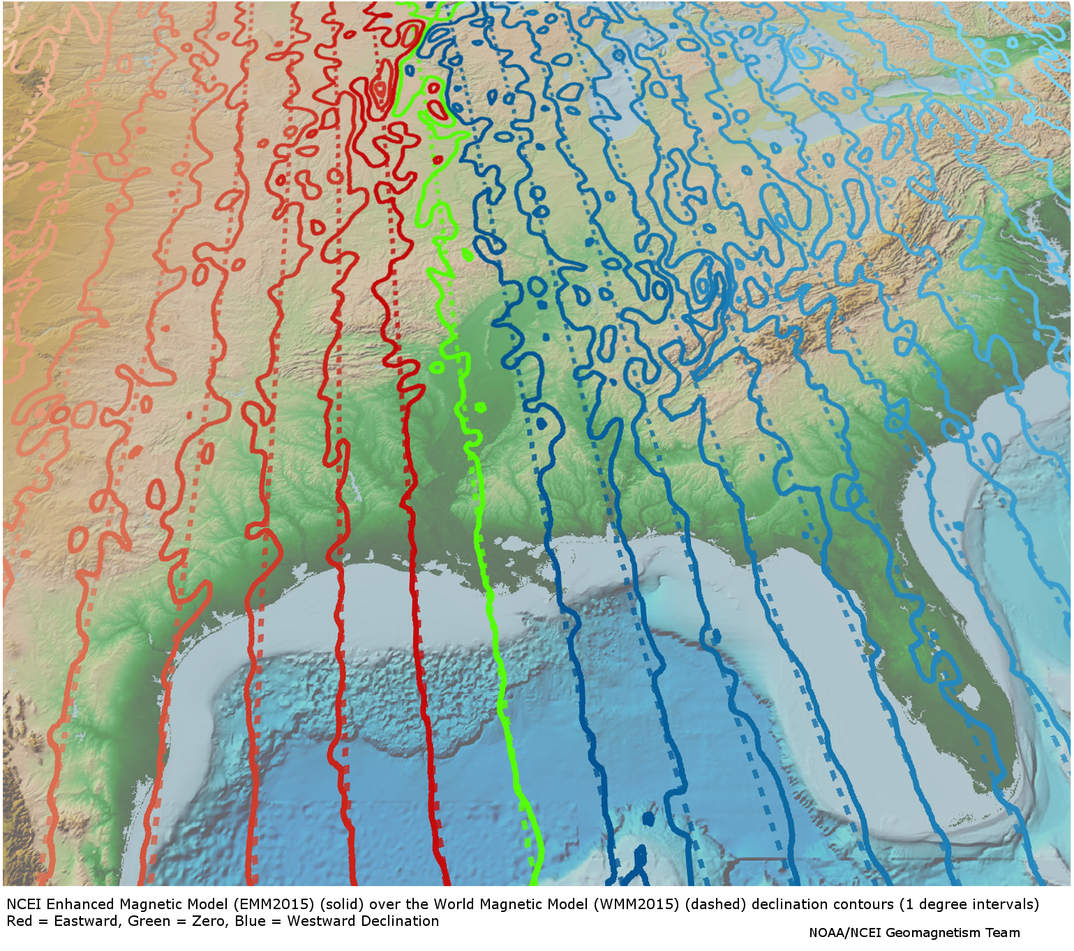
| (MI_Metadata) fileIdentifier: gov.noaa.ngdc.mgg.geophysical_models:EMM2015 hierarchyLevel: (MD_ScopeCode) model hierarchyLevelName: Magnetic Grid contact: (CI_ResponsibleParty) organisationName: NOAA National Centers for Environmental Information contactInfo: (CI_Contact) address: (CI_Address) electronicMailAddress: ncei.info@noaa.gov onlineResource: (CI_OnlineResource) linkage: https://www.ncei.noaa.gov/contact name: NCEI Contact Information description: Information for contacts at NCEI. function: (CI_OnLineFunctionCode) information role: (CI_RoleCode) pointOfContact dateStamp: 2020-05-14 metadataStandardName: ISO 19115-2 Geographic Information - Metadata - Part 2: Extensions for Imagery and Gridded Data metadataStandardVersion: ISO 19115-2:2009(E) return to top spatialRepresentationInfo: (MD_GridSpatialRepresentation) numberOfDimensions: 2 cellGeometry: (MD_CellGeometryCode) point transformationParameterAvailability: true return to top referenceSystemInfo: (MD_ReferenceSystem) referenceSystemIdentifier: (RS_Identifier) authority: (CI_Citation) title: World Geodetic System 1984 alternateTitle: WGS 84 date: (CI_Date) date: 2007-08-27 dateType: (CI_DateTypeCode) revision citedResponsibleParty: (CI_ResponsibleParty) organisationName: (withheld) contactInfo: (CI_Contact) onlineResource: (CI_OnlineResource) linkage: https://epsg.org/crs_4326/WGS-84.html name: WGS 84 description: GML of World Geodetic System 1984 coordinate reference system. function: (CI_OnLineFunctionCode) information role: (CI_RoleCode) resourceProvider citedResponsibleParty: (CI_ResponsibleParty) organisationName: European Petroleum Survey Group contactInfo: (CI_Contact) onlineResource: (CI_OnlineResource) linkage: https://epsg.org/home.html name: European Petroleum Survey Group Geodetic Parameter Registry description: Registry that accesses the EPSG Geodetic Parameter Dataset, which is a structured dataset of Coordinate Reference Systems and Coordinate Transformations. function: (CI_OnLineFunctionCode) search role: (CI_RoleCode) publisher code: urn:ogc:def:crs:EPSG::4326 return to top identificationInfo: (MD_DataIdentification) citation: (CI_Citation) title: Enhanced Magnetic Model 2015 date: (CI_Date) date: 2015-05-15 dateType: (CI_DateTypeCode) publication edition: 1 editionDate: 2015-05-15 identifier: (MD_Identifier) authority: (CI_Citation) title: International DOI Foundation (IDF) date: (inapplicable) code: Anchor: DOI doi:10.7289/V56971HV identifier: (MD_Identifier) authority: (CI_Citation) title: NOAA National Centers for Environmental Information date: (inapplicable) code: NCEI Metadata ID: gov.noaa.ngdc.mgg.geophysical_models:EMM2015 citedResponsibleParty: (CI_ResponsibleParty) positionName: Chulliat, A. role: (CI_RoleCode) author citedResponsibleParty: (CI_ResponsibleParty) positionName: P. Alken role: (CI_RoleCode) author citedResponsibleParty: (CI_ResponsibleParty) positionName: Nair, A. Woods role: (CI_RoleCode) author citedResponsibleParty: (CI_ResponsibleParty) positionName: S. Maus role: (CI_RoleCode) author citedResponsibleParty: (CI_ResponsibleParty) positionName: NCEI Geomagnetic Modeling Team role: (CI_RoleCode) originator citedResponsibleParty: (CI_ResponsibleParty) organisationName: NOAA National Centers for Environmental Information role: (CI_RoleCode) publisher presentationForm: (CI_PresentationFormCode) mapDigital abstract: The Enhanced Magnetic Model (EMM) extends to degree and order 720, resolving magnetic anomalies down to 56 km wavelength. The higher resolution of the EMM results in significantly improved pointing accuracy than the World Magnetic Model (WMM), which uses spherical harmonic representation to degree and order 12, resolving the magnetic field at 3000 km wavelength. The EMM model provides the magnetic field vector at any desired location and altitude close to and above the Earth's surface. purpose: Magnetic anomaly maps provide insight into the subsurface structure and composition of the Earth's crust. Over continental areas, magnetic anomalies illuminate geologic, tectonic, and geothermal evolution of crust and lithosphere. In the world's oceans, anomalies trending parallel to the isochrons (lines of equal age) reveal the temporal evolution of oceanic crust. Magnetic maps are widely used in the geological sciences and in resource exploration. status: (MD_ProgressCode) completed status: (MD_ProgressCode) historicalArchive pointOfContact: (CI_ResponsibleParty) organisationName: NOAA National Centers for Environmental Information contactInfo: (CI_Contact) address: (CI_Address) electronicMailAddress: ncei.info@noaa.gov onlineResource: (CI_OnlineResource) linkage: https://www.ncei.noaa.gov/contact name: NCEI Contact Information description: Information for contacts at NCEI. function: (CI_OnLineFunctionCode) information role: (CI_RoleCode) pointOfContact pointOfContact: (CI_ResponsibleParty) organisationName: NOAA National Centers for Environmental Information positionName: NCEI Geomagnetic Modeling Team contactInfo: (CI_Contact) address: (CI_Address) electronicMailAddress: geomag.models@noaa.gov role: (CI_RoleCode) pointOfContact resourceMaintenance: (MD_MaintenanceInformation) maintenanceAndUpdateFrequency: (MD_MaintenanceFrequencyCode) asNeeded graphicOverview: (MD_BrowseGraphic) fileName: https://www.ngdc.noaa.gov/geomag/EMM/img/dec_WMM_EMM.jpg fileDescription: Declination Comparison of WMM and EMM fileType: JPG descriptiveKeywords: (MD_Keywords) keyword: Earth Science > Solid Earth > Geomagnetism > Magnetic Field keyword: Earth Science > Solid Earth > Geomagnetism > Magnetic Intensity keyword: Earth Science > Solid Earth > Geomagnetism > Magnetic Declination keyword: Earth Science > Solid Earth > Geomagnetism > Magnetic Inclination keyword: Earth Science > Solid Earth > Geomagnetism > Magnetic Anomalies type: (MD_KeywordTypeCode) theme thesaurusName: (CI_Citation) title: Global Change Master Directory (GCMD) Science Keywords date: (CI_Date) date: 2020-01-09 dateType: (CI_DateTypeCode) publication edition: 9.1 citedResponsibleParty: (CI_ResponsibleParty) organisationName: NASA Goddard Space Flight Center, Earth Science Data and Information System contactInfo: (CI_Contact) onlineResource: (CI_OnlineResource) linkage: https://www.earthdata.nasa.gov/learn/find-data/idn/gcmd-keywords name: Global Change Master Directory (GCMD) Keywords description: The information provided on this page seeks to define how the GCMD Keywords are structured, used and accessed. It also provides information on how users can participate in the further development of the keywords. function: (CI_OnLineFunctionCode) information role: (CI_RoleCode) custodian descriptiveKeywords: (MD_Keywords) keyword: DOC/NOAA/NESDIS/NCEI > National Centers for Environmental Information, NESDIS, NOAA, U.S. Department of Commerce keyword: DOC/NOAA/NESDIS/NGDC > National Geophysical Data Center, NESDIS, NOAA, U.S. Department of Commerce type: (MD_KeywordTypeCode) dataCentre thesaurusName: (CI_Citation) title: Global Change Master Directory (GCMD) Data Center Keywords date: (CI_Date) date: 2020-01-09 dateType: (CI_DateTypeCode) publication edition: 9.1 citedResponsibleParty: (CI_ResponsibleParty) organisationName: NASA Goddard Space Flight Center, Earth Science Data and Information System contactInfo: (CI_Contact) onlineResource: (CI_OnlineResource) linkage: https://www.earthdata.nasa.gov/learn/find-data/idn/gcmd-keywords name: Global Change Master Directory (GCMD) Keywords description: The information provided on this page seeks to define how the GCMD Keywords are structured, used and accessed. It also provides information on how users can participate in the further development of the keywords. function: (CI_OnLineFunctionCode) information role: (CI_RoleCode) custodian descriptiveKeywords: (MD_Keywords) keyword: Geographic Region > Global type: (MD_KeywordTypeCode) place thesaurusName: (CI_Citation) title: Global Change Master Directory (GCMD) Location Keywords date: (CI_Date) date: 2020-01-09 dateType: (CI_DateTypeCode) publication edition: 9.1 citedResponsibleParty: (CI_ResponsibleParty) organisationName: NASA Goddard Space Flight Center, Earth Science Data and Information System contactInfo: (CI_Contact) onlineResource: (CI_OnlineResource) linkage: https://www.earthdata.nasa.gov/learn/find-data/idn/gcmd-keywords name: Global Change Master Directory (GCMD) Keywords description: The information provided on this page seeks to define how the GCMD Keywords are structured, used and accessed. It also provides information on how users can participate in the further development of the keywords. function: (CI_OnLineFunctionCode) information role: (CI_RoleCode) custodian resourceConstraints: (MD_LegalConstraints) accessConstraints: (MD_RestrictionCode) otherRestrictions otherConstraints: Distribution liability: NOAA and NCEI make no warranty, expressed or implied, regarding these data, nor does the fact of distribution constitute such a warranty. NOAA and NCEI cannot assume liability for any damages caused by any errors or omissions in these data. If appropriate, NCEI can only certify that the data it distributes are an authentic copy of the records that were accepted for inclusion in the NCEI archives. resourceConstraints: (MD_LegalConstraints) useConstraints: (MD_RestrictionCode) otherRestrictions otherConstraints: Use liability: NOAA and NCEI cannot provide any warranty as to the accuracy, reliability, or completeness of furnished data. Users assume responsibility to determine the usability of these data. The user is responsible for the results of any application of this data for other than its intended purpose. resourceConstraints: (MD_Constraints) useLimitation: Produced by the NOAA National Centers for Environmental Information. Not subject to copyright protection within the United States. resourceConstraints: (MD_LegalConstraints) useLimitation: (MD_RestrictionCode) otherRestrictions otherConstraints: Cite as: Chulliat, A.. P. Alken. Nair, A. Woods. S. Maus. 2015: Enhanced Magnetic Model 2015. 1. NOAA National Centers for Environmental Information. https://doi.org/10.7289/V56971HV. Accessed [date]. spatialRepresentationType: (MD_SpatialRepresentationTypeCode) grid language: eng; USA topicCategory: (MD_TopicCategoryCode) geoscientificInformation extent: (EX_Extent) geographicElement: (EX_GeographicBoundingBox) westBoundLongitude: -180 eastBoundLongitude: 180 southBoundLatitude: -90 northBoundLatitude: 90 temporalElement: (EX_TemporalExtent) extent: TimePeriod: beginPosition: 2000-01-01 endPosition: 2019-12-31 return to top contentInfo: (MI_CoverageDescription) attributeDescription: RecordType: Grid Cell contentType: (MD_CoverageContentTypeCode) modelResult dimension: (MD_Band) descriptor: Northerly Intensity maxValue: Real: 42000 minValue: Real: -17000 units: BaseUnit: identifier: nanoTesla unitsSystem: dimension: (MD_Band) descriptor: Easterly Intensity maxValue: Real: 17000 minValue: Real: -18000 units: BaseUnit: identifier: nanoTesla unitsSystem: dimension: (MD_Band) descriptor: Vertical Intensity maxValue: Real: 61000 minValue: Real: -67000 units: BaseUnit: identifier: nanoTesla unitsSystem: dimension: (MD_Band) descriptor: Horizontal Intensity maxValue: Real: 42000 minValue: Real: 00 units: BaseUnit: identifier: nanoTesla unitsSystem: dimension: (MD_Band) descriptor: Total Intensity maxValue: Real: 67000 minValue: Real: 22000 units: BaseUnit: identifier: nanoTesla unitsSystem: dimension: (MD_Band) descriptor: Inclination maxValue: Real: 90 minValue: Real: -90 units: BaseUnit: identifier: degree unitsSystem: dimension: (MD_Band) descriptor: Declination maxValue: Real: 90 minValue: Real: -90 units: BaseUnit: identifier: degree unitsSystem: dimension: (MD_Band) descriptor: Grid Variation maxValue: Real: 180 minValue: Real: -180 units: BaseUnit: identifier: degree unitsSystem: return to top distributionInfo: (MD_Distribution) distributor: (MD_Distributor) distributorContact: (CI_ResponsibleParty) organisationName: NOAA National Centers for Environmental Information contactInfo: (CI_Contact) address: (CI_Address) electronicMailAddress: ncei.info@noaa.gov onlineResource: (CI_OnlineResource) linkage: https://www.ncei.noaa.gov/contact name: NCEI Contact Information description: Information for contacts at NCEI. function: (CI_OnLineFunctionCode) information role: (CI_RoleCode) distributor distributionOrderProcess: (MD_StandardOrderProcess) fees: In most cases, electronic downloads of the data are free. However, fees may apply for custom orders, data certifications, copies of analog materials, and data distribution on physical media. orderingInstructions: Contact NCEI for other distribution options and instructions. distributorFormat: (MD_Format) name: EMM2015_Sph_Linux.zip version: 4 specification: Enhanced Magnetic Model (EMM2015) and software using the spherical harmonic approach for Linux environments. High CPU requirements (use the faster Mesh software for large number of points), very low RAM requirement. For use with years 2000 to 2020. distributorFormat: (MD_Format) name: EMM2015_Sph_Windows.zip version: 4 specification: Enhanced Magnetic Model (EMM2015) and software using the spherical harmonic approach for Windows environments. High CPU requirements (use the faster Mesh software for large number of points), very low RAM requirement. For use with years 2000 to 2020. distributorFormat: (MD_Format) name: EMM2015_Sph_Mac.zip version: 4 specification: Enhanced Magnetic Model (EMM2015) and software using the spherical harmonic approach for Mac environments. High CPU requirements (use the faster Mesh software for large number of points), very low RAM requirement. For use with years 2000 to 2020. distributorTransferOptions: (MD_DigitalTransferOptions) onLine: (CI_OnlineResource) linkage: https://www.ncei.noaa.gov/metadata/geoportal/rest/metadata/item/gov.noaa.ngdc.mgg.geophysical_models:EMM2015/html protocol: HTTPS name: Metadata Landing Page function: (CI_OnLineFunctionCode) information distributorTransferOptions: (MD_DigitalTransferOptions) onLine: (CI_OnlineResource) linkage: https://www.ngdc.noaa.gov/geomag/EMM/index.html protocol: HTTPS name: EMM Home Page function: (CI_OnLineFunctionCode) information distributorTransferOptions: (MD_DigitalTransferOptions) onLine: (CI_OnlineResource) linkage: https://www.ngdc.noaa.gov/geomag/EMM/EMMSurveySPH.shtml name: EMM2015_Sph_Linux.zip description: Enhanced Magnetic Model (EMM2015) and software using the spherical harmonic approach for Linux environments. High CPU requirements (use the faster Mesh software for large number of points), very low RAM requirement. For use with years 2000 to 2020. function: (CI_OnLineFunctionCode) download distributorTransferOptions: (MD_DigitalTransferOptions) onLine: (CI_OnlineResource) linkage: https://www.ngdc.noaa.gov/geomag/EMM/EMMSurveySPH.shtml name: EMM2015_Sph_Windows.zip description: Enhanced Magnetic Model (EMM2015) and software using the spherical harmonic approach for Windows environments. High CPU requirements (use the faster Mesh software for large number of points), very low RAM requirement. For use with years 2000 to 2020. function: (CI_OnLineFunctionCode) download distributorTransferOptions: (MD_DigitalTransferOptions) onLine: (CI_OnlineResource) linkage: https://www.ngdc.noaa.gov/geomag/EMM/EMMSurveySPH.shtml name: EMM2015_Sph_Mac.zip description: Enhanced Magnetic Model (EMM2015) and software using the spherical harmonic approach for Mac environments. High CPU requirements (use the faster Mesh software for large number of points), very low RAM requirement. For use with years 2000 to 2020. function: (CI_OnLineFunctionCode) download return to top dataQualityInfo: (DQ_DataQuality) scope: (DQ_Scope) level: (MD_ScopeCode) repository levelDescription: (MD_ScopeDescription) other: NOAA National Centers for Environmental Information lineage: (LI_Lineage) processStep: (LE_ProcessStep) description: NOAA created the National Centers for Environmental Information (NCEI) by merging NOAA's National Climatic Data Center (NCDC), National Geophysical Data Center (NGDC), and National Oceanographic Data Center (NODC), including the National Coastal Data Development Center (NCDDC), per the Consolidated and Further Continuing Appropriations Act, 2015, Public Law 113-235. NCEI launched publicly on April 22, 2015. dateTime: DateTime: 2015-04-22T00:00:00 return to top dataQualityInfo: (DQ_DataQuality) scope: (DQ_Scope) level: (MD_ScopeCode) dataset lineage: (LI_Lineage) processStep: (LE_ProcessStep) description: Measurements during daytime and during periods of strong solar activity are contaminated by external current systems, which are difficult to accurately model. Therefore, only nighttime data during magnetically quiet periods were used in estimating the WMM coefficients. processor: (CI_ResponsibleParty) organisationName: NOAA National Centers for Environmental Information positionName: NCEI Geomagnetic Modeling Team contactInfo: (CI_Contact) address: (CI_Address) electronicMailAddress: geomag.models@noaa.gov role: (CI_RoleCode) pointOfContact processingInformation: (LE_Processing) identifier: (MD_Identifier) code: Processing steps were carried out collectively by the developers of the model. These developers are listed as authors of the associated paper "The US/UK World Magnetic Model 2015-2020". algorithm: (LE_Algorithm) citation: (CI_Citation) title: The US/UK World Magnetic Model for 2015-2020 date: (CI_Date) date: 2009-12-01 dateType: (CI_DateTypeCode) publication citedResponsibleParty: (CI_ResponsibleParty) contactInfo: (CI_Contact) onlineResource: (CI_OnlineResource) linkage: https://www.ngdc.noaa.gov/geomag/WMM/data/WMM2015/WMM2015_Report.pdf role: (CI_RoleCode) originator description: Refer to technical report, "The US/UK World Magnetic Model 2015-2020", for description of gridding algorithms. processStep: (LE_ProcessStep) description: Some contributions to the measured magnetic field, such as the diamagnetic effect of ionospheric plasma (Lﮰhr et al, 2003) or motional induction by tidal ocean currents (Kuvshinov and Olsen, 2005; Maus, 2007), can be accurately modeled and were corrected for prior to the estimation of the WMM main field coefficients. processor: (CI_ResponsibleParty) organisationName: NOAA National Centers for Environmental Information positionName: NCEI Geomagnetic Modeling Team contactInfo: (CI_Contact) address: (CI_Address) electronicMailAddress: geomag.models@noaa.gov role: (CI_RoleCode) pointOfContact processingInformation: (LE_Processing) identifier: (MD_Identifier) code: Processing steps were carried out collectively by the developers of the model. These developers are listed as authors of the associated paper "The US/UK World Magnetic Model 2015-2020". algorithm: (LE_Algorithm) citation: (CI_Citation) title: The US/UK World Magnetic Model for 2015-2020 date: (CI_Date) date: 2009-12-01 dateType: (CI_DateTypeCode) publication citedResponsibleParty: (CI_ResponsibleParty) contactInfo: (CI_Contact) onlineResource: (CI_OnlineResource) linkage: https://www.ngdc.noaa.gov/geomag/WMM/data/WMM2015/WMM2015_Report.pdf role: (CI_RoleCode) originator description: Refer to technical report, "The US/UK World Magnetic Model 2015-2020", for description of gridding algorithms. processStep: (LE_ProcessStep) description: To account for the contributions that have not been removed in the previous steps, an extended set of model parameters is co-estimated with the WMM model coefficients. These account for smaller-wavelength internal magnetic field contributions (spherical harmonic degree larger than 12), second time derivatives (secular acceleration) and contributions from currents external to the Earth. The set of WMM coefficients plus the extended model parameters is called a parent model of the WMM. Two different parent models were produced, reflecting different modeling strategies employed by NGDC for the main field model and BGS for the secular variation model. processor: (CI_ResponsibleParty) organisationName: NOAA National Centers for Environmental Information positionName: NCEI Geomagnetic Modeling Team contactInfo: (CI_Contact) address: (CI_Address) electronicMailAddress: geomag.models@noaa.gov role: (CI_RoleCode) pointOfContact processingInformation: (LE_Processing) identifier: (MD_Identifier) code: Processing steps were carried out collectively by the developers of the model. These developers are listed as authors of the associated paper "The US/UK World Magnetic Model 2015-2020" which can be found at https://www.ngdc.noaa.gov/geomag/WMM/data/WMM2015/WMM2015_Report.pdf algorithm: (LE_Algorithm) citation: (CI_Citation) title: The US/UK World Magnetic Model for 2015-2020 date: (CI_Date) date: 2009-12-01 dateType: (CI_DateTypeCode) publication citedResponsibleParty: (CI_ResponsibleParty) contactInfo: (CI_Contact) onlineResource: (CI_OnlineResource) linkage: https://www.ngdc.noaa.gov/geomag/WMM/data/WMM2015/WMM2015_Report.pdf role: (CI_RoleCode) originator description: Refer to technical report, "The US/UK World Magnetic Model 2015-2020", for description of gridding algorithms. processStep: (LE_ProcessStep) description: Satellite, marine, and aeromagnetic measurements were compiled into an ellipsoidal degree-720 magnetic model of the Earth's lithosphere. This model accurately represents the crustal field down to wavelengths of approximately 56 kilometers. This results in a higher pointing accuracy. processor: (CI_ResponsibleParty) organisationName: NOAA National Centers for Environmental Information positionName: NCEI Geomagnetic Modeling Team contactInfo: (CI_Contact) address: (CI_Address) electronicMailAddress: geomag.models@noaa.gov role: (CI_RoleCode) pointOfContact processingInformation: (LE_Processing) identifier: (MD_Identifier) code: Processing steps were carried out collectively by the developers of the model. These developers are listed as authors of the associated paper "An ellipsoidal harmonic representation of Earth's lithospheric magnetic field to degree and order 720". algorithm: (LE_Algorithm) citation: (CI_Citation) title: An ellipsoidal harmonic representation of Earth's lithospheric magnetic field to degree and order 720 date: (CI_Date) date: 2015-03-25 dateType: (CI_DateTypeCode) creation citedResponsibleParty: (CI_ResponsibleParty) contactInfo: (CI_Contact) onlineResource: (CI_OnlineResource) linkage: http://geomag.colorado.edu/images/PublicationsPDFs/ngdc720.pdf role: (CI_RoleCode) originator description: Refer to technical report, "An ellipsoidal harmonic representation of Earth's lithospheric magnetic field to degree and order 720", for description of gridding algorithms. source: (LI_Source) description: European Space Agency (ESA) Swarm Magnetic Satellite Mission sourceCitation: (CI_Citation) title: Swarm Satellite Data date: (CI_Date) date: 2013-11-20 dateType: (CI_DateTypeCode) creation citedResponsibleParty: (CI_ResponsibleParty) organisationName: European Space Agency contactInfo: (CI_Contact) onlineResource: (CI_OnlineResource) linkage: http://earth.esa.int/web/guest/swarm/data-access name: Swarm Earth Explorers description: Webpage provided details on equipment, mission, as well as results and publications associated with the Swarm mission. function: (CI_OnLineFunctionCode) information role: (CI_RoleCode) originator sourceExtent: (EX_Extent) geographicElement: (EX_GeographicBoundingBox) westBoundLongitude: -180 eastBoundLongitude: 180 southBoundLatitude: -90 northBoundLatitude: 90 temporalElement: (EX_TemporalExtent) extent: TimePeriod: beginPosition: 2013-11-24 endPosition: 2015-04-19 source: (LI_Source) description: Challenging Minisatellite Payload (CHAMP) is a German satellite mission dedicated to improving gravity and magnetic field models of the Earth. sourceCitation: (CI_Citation) title: CHAMP Satellite Data date: (CI_Date) date: 2009-12-31 dateType: (CI_DateTypeCode) publication citedResponsibleParty: (CI_ResponsibleParty) organisationName: GFZ German Research Centre for Geosciences contactInfo: (CI_Contact) onlineResource: (CI_OnlineResource) linkage: http://op.gfz-potsdam.de/champ/ name: The CHAMP Mission description: Webpage provided details on equipment, mission, as well as results and publications associated with the CHAMP mission. function: (CI_OnLineFunctionCode) information role: (CI_RoleCode) originator sourceExtent: (EX_Extent) geographicElement: (EX_GeographicBoundingBox) westBoundLongitude: -180 eastBoundLongitude: 180 southBoundLatitude: -90 northBoundLatitude: 90 temporalElement: (EX_TemporalExtent) extent: TimePeriod: beginPosition: 2000-07-15 endPosition: 2010-09-19 source: (LI_Source) description: The Danish satellite Orsted is a dedicated satellite for geomagnetic field modeling. sourceCitation: (CI_Citation) title: ORSTED Satellite Data date: (CI_Date) date: 2009-12-31 dateType: (CI_DateTypeCode) publication citedResponsibleParty: (CI_ResponsibleParty) organisationName: Danish Meteorological Institute contactInfo: (CI_Contact) onlineResource: (CI_OnlineResource) linkage: http://www.space.dtu.dk/english/Research/Projects/Oersted name: The Orsted Satellite Project description: Webpage provided details on equipment, mission, as well as results and publications associated with the Orsted satellite mission. function: (CI_OnLineFunctionCode) information role: (CI_RoleCode) originator sourceExtent: (EX_Extent) geographicElement: (EX_GeographicBoundingBox) westBoundLongitude: -180 eastBoundLongitude: 180 southBoundLatitude: -90 northBoundLatitude: 90 temporalElement: (EX_TemporalExtent) extent: TimePeriod: beginPosition: 1999-02-23 endPosition: 2009-11-30 source: (LI_Source) description: Magnetics information that is collected at permanent surface magnetic observatories spread across the globe. sourceCitation: (CI_Citation) title: INTERMAGNET Observatory Data date: (CI_Date) date: 2009-12-31 dateType: (CI_DateTypeCode) publication citedResponsibleParty: (CI_ResponsibleParty) organisationName: International Real-time Magnetic Observatory Network contactInfo: (CI_Contact) onlineResource: (CI_OnlineResource) linkage: http://www.intermagnet.org name: INTERMAGNET Program description: Website provides information on participating institutions, observatory locations, and publications associated with the network of observatories. function: (CI_OnLineFunctionCode) information role: (CI_RoleCode) originator sourceExtent: (EX_Extent) geographicElement: (EX_GeographicBoundingBox) westBoundLongitude: -177.383 eastBoundLongitude: 172.35 southBoundLatitude: -77.85 northBoundLatitude: 82.5 source: (LI_Source) description: Trackline magnetics observations hosted on GEODAS at the National Centers for Environmental Information (NCEI). sourceCitation: (CI_Citation) title: GEODAS magnetic data date: (CI_Date) date: 2013-02-06 dateType: (CI_DateTypeCode) revision citedResponsibleParty: (CI_ResponsibleParty) individualName: Brian Meyer organisationName: NOAA National Centers for Environmental Information contactInfo: (CI_Contact) phone: (CI_Telephone) voice: 303-497-6125 address: (CI_Address) electronicMailAddress: Brian.Meyer@noaa.gov role: (CI_RoleCode) pointOfContact sourceExtent: (EX_Extent) geographicElement: (EX_GeographicBoundingBox) westBoundLongitude: -180 eastBoundLongitude: 180 southBoundLatitude: -90 northBoundLatitude: 90 return to top metadataMaintenance: (MD_MaintenanceInformation) maintenanceAndUpdateFrequency: (MD_MaintenanceFrequencyCode) asNeeded maintenanceNote: Modified for compliance to NCEI Template v1.2. | |