| Total Sediment Thickness of the World's Oceans & Marginal Seas | referenceSystemInfo|
|---|---|
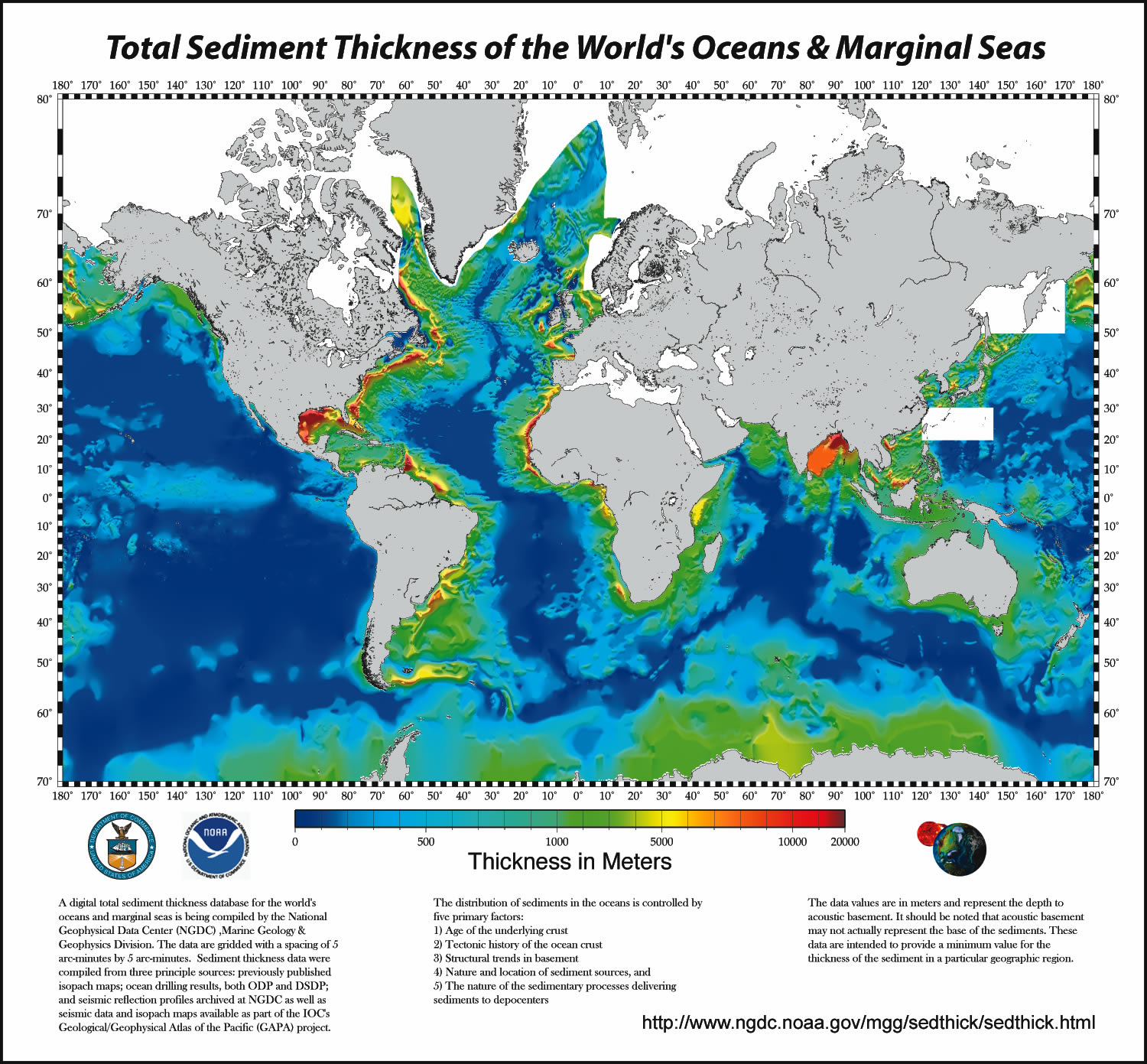
| а(MI_Metadata) ааааfileIdentifier: аgov.noaa.ngdc.mgg.geophysics:G01065 ааааlanguage: аeng; USA ааааcharacterSet: а(MD_CharacterSetCode)аutf8 ааааhierarchyLevel: а(MD_ScopeCode)аdataset ааааcontact: а(CI_ResponsibleParty) ааааааааindividualName: аBrian Meyer ааааааааorganisationName: аNOAA National Centers for Environmental Information ааааааааcontactInfo: а(CI_Contact) ааааааааааааphone: а(CI_Telephone) ааааааааааааааааvoice: а303-497-6125 ааааааааааааaddress: а(CI_Address) ааааааааааааааааelectronicMailAddress: аBrian.Meyer@noaa.gov ааааааааrole: а(CI_RoleCode)аpointOfContact ааааdateStamp: а2017-09-25 ааааmetadataStandardName: аISO 19115-2 Geographic Information - Metadata - Part 2: Extensions for Imagery and Gridded Data ааааmetadataStandardVersion: аISO 19115-2:2009(E) return to top ааааreferenceSystemInfo: а(MD_ReferenceSystem) ааааааааreferenceSystemIdentifier: а(RS_Identifier) ааааааааааааauthority: а(CI_Citation) ааааааааааааааааtitle: аWorld Geodetic System 1984 ааааааааааааааааalternateTitle: аWGS 84 ааааааааааааааааdate: а(CI_Date) ааааааааааааааааааааdate: а2007-08-27 ааааааааааааааааааааdateType: а(CI_DateTypeCode)аrevision ааааааааааааааааcitedResponsibleParty: а(CI_ResponsibleParty) ааааааааааааааааааааorganisationName: (withheld) ааааааааааааааааааааcontactInfo: а(CI_Contact) ааааааааааааааааааааааааonlineResource: а(CI_OnlineResource) ааааааааааааааааааааааааааааlinkage: https://epsg.org/crs_4326/WGS-84.html ааааааааааааааааааааааааааааname: аWGS 84 ааааааааааааааааааааааааааааdescription: аGML of World Geodetic System 1984 coordinate reference system. ааааааааааааааааааааааааааааfunction: а(CI_OnLineFunctionCode)аinformation ааааааааааааааааааааrole: а(CI_RoleCode)аresourceProvider ааааааааааааааааcitedResponsibleParty: а(CI_ResponsibleParty) ааааааааааааааааааааorganisationName: аEuropean Petroleum Survey Group ааааааааааааааааааааcontactInfo: а(CI_Contact) ааааааааааааааааааааааааonlineResource: а(CI_OnlineResource) ааааааааааааааааааааааааааааlinkage: https://epsg.org/home.html ааааааааааааааааааааааааааааname: аEuropean Petroleum Survey Group Geodetic Parameter Registry ааааааааааааааааааааааааааааdescription: аRegistry that accesses the EPSG Geodetic Parameter Dataset, which is a structured dataset of Coordinate Reference Systems and Coordinate Transformations. ааааааааааааааааааааааааааааfunction: а(CI_OnLineFunctionCode)аsearch ааааааааааааааааааааrole: а(CI_RoleCode)аpublisher ааааааааааааcode: аurn:ogc:def:crs:EPSG::4326 return to top ааааidentificationInfo: а(MD_DataIdentification) ааааааааcitation: а(CI_Citation) ааааааааааааtitle: аTotal Sediment Thickness of the World's Oceans & Marginal Seas ааааааааааааdate: а(CI_Date) ааааааааааааааааdate: а2003-12-23 ааааааааааааааааdateType: а(CI_DateTypeCode)аpublication ааааааааааааcitedResponsibleParty: а(CI_ResponsibleParty) ааааааааааааааааorganisationName: аNOAA National Centers for Environmental Information ааааааааааааааааrole: а(CI_RoleCode)аpublisher ааааааааааааcitedResponsibleParty: а(CI_ResponsibleParty) ааааааааааааааааorganisationName: аDOC/NOAA/NESDIS/NCEI > National Centers for Environmental Information, NESDIS, NOAA, U.S. Department of Commerce ааааааааааааааааpositionName: аUser Services ааааааааааааааааcontactInfo: а(CI_Contact) ааааааааааааааааааааphone: а(CI_Telephone) ааааааааааааааааааааааааvoice: а303-497-6826 ааааааааааааааааааааааааfacsimile: а303-497-6513 ааааааааааааааааааааaddress: а(CI_Address) ааааааааааааааааааааааааdeliveryPoint: а325 Broadway ааааааааааааааааааааааааcity: аBoulder ааааааааааааааааааааааааadministrativeArea: аCO ааааааааааааааааааааааааpostalCode: а80305-3328 ааааааааааааааааааааааааcountry: аUSA ааааааааааааааааааааааааelectronicMailAddress: аngdc.info@noaa.gov ааааааааааааааааааааhoursOfService: а8am-5pm, Monday through Friday ааааааааааааааааrole: а(CI_RoleCode)аpublisher ааааааааааааcitedResponsibleParty: а(CI_ResponsibleParty) ааааааааааааааааindividualName: аBarry W. Eakins ааааааааааааааааorganisationName: аNOAA National Centers for Environmental Information ааааааааааааааааpositionName: аResearch Scientist ааааааааааааааааcontactInfo: а(CI_Contact) ааааааааааааааааааааphone: а(CI_Telephone) ааааааааааааааааааааааааvoice: а303-497-6505 ааааааааааааааааааааaddress: а(CI_Address) ааааааааааааааааааааааааdeliveryPoint: а325 Broadway, E/GC3 ааааааааааааааааааааааааcity: аBoulder ааааааааааааааааааааааааadministrativeArea: аColorado ааааааааааааааааааааааааpostalCode: а80305-3328 ааааааааааааааааааааааааcountry: аUSA ааааааааааааааааааааааааelectronicMailAddress: аBarry.Eakins@noaa.gov ааааааааааааааааааааhoursOfService: а9am-5pm, M-F, Mountain Time ааааааааааааааааааааcontactInstructions: аContact Marine Geology and Geophysics Division ааааааааааааааааrole: а(CI_RoleCode)аoriginator ааааааааааааpresentationForm: а(CI_PresentationFormCode)аmapDigital ааааааааabstract: аA digital total-sediment-thickness database for the world's oceans and marginal seas has been compiled by the NOAA National Geophysical Data Center (NGDC). The data were gridded with a grid spacing of 5 arc-minutes by 5 arc-minutes. Sediment-thickness data were compiled from three principle sources: (i) previously published isopach maps including Ludwig and Houtz [1979], Matthias et al. [1988], Divins and Rabinowitz [1990], Hayes and LaBrecque [1991], and Divins [2003]; (ii) ocean drilling results, both from the Ocean Drilling Program (ODP) and the Deep Sea Drilling Project (DSDP); and (iii) seismic reflection profiles archived at NGDC as well as seismic data and isopach maps available as part of the IOC's International Geological-Geophysical Atlas of the Pacific Ocean [Udinstev, 2003]. ааааааааpurpose: аTo create a global sediment-thickness database for use by researchers and interested public. ааааааааstatus: а(MD_ProgressCode)аcompleted ааааааааpointOfContact: а(CI_ResponsibleParty) ааааааааааааindividualName: аBarry W. Eakins ааааааааааааorganisationName: аNOAA National Centers for Environmental Information ааааааааааааpositionName: аResearch Scientist ааааааааааааcontactInfo: а(CI_Contact) ааааааааааааааааphone: а(CI_Telephone) ааааааааааааааааааааvoice: а303-497-6505 ааааааааааааааааaddress: а(CI_Address) ааааааааааааааааааааdeliveryPoint: а325 Broadway, E/GC3 ааааааааааааааааааааcity: аBoulder ааааааааааааааааааааadministrativeArea: аColorado ааааааааааааааааааааpostalCode: а80305-3328 ааааааааааааааааааааcountry: аUSA ааааааааааааааааааааelectronicMailAddress: аBarry.Eakins@noaa.gov ааааааааааааааааhoursOfService: а9am-5pm, M-F, Mountain Time ааааааааааааааааcontactInstructions: аContact Marine Geology and Geophysics Division ааааааааааааrole: а(CI_RoleCode)аpointOfContact ааааааааresourceMaintenance: а(MD_MaintenanceInformation) ааааааааааааmaintenanceAndUpdateFrequency: а(MD_MaintenanceFrequencyCode)аasNeeded ааааааааgraphicOverview: а(MD_BrowseGraphic) ааааааааааааfileName: https://www.ngdc.noaa.gov/mgg/image/sedthick9.jpg ааааааааааааfileDescription: аImage of total sediment thickness of the world's oceans and marginal seas. ааааааааааааfileType: аJPG ааааааааdescriptiveKeywords: а(MD_Keywords) ааааааааааааkeyword: аEARTH SCIENCE>OCEANS>Marine Sediments ааааааааааааtype: а(MD_KeywordTypeCode)аtheme ааааааааааааthesaurusName: а(CI_Citation) ааааааааааааааааtitle: аGlobal Change Master Directory (GCMD) Science Keywords ааааааааааааааааdate: а(CI_Date) ааааааааааааааааааааdate: а2020-01-09 ааааааааааааааааааааdateType: а(CI_DateTypeCode)аpublication ааааааааааааааааedition: а9.1 ааааааааааааааааcitedResponsibleParty: а(CI_ResponsibleParty) ааааааааааааааааааааorganisationName: аNASA Goddard Space Flight Center, Earth Science Data and Information System ааааааааааааааааааааcontactInfo: а(CI_Contact) ааааааааааааааааааааааааonlineResource: а(CI_OnlineResource) ааааааааааааааааааааааааааааlinkage: https://www.earthdata.nasa.gov/learn/find-data/idn/gcmd-keywords ааааааааааааааааааааааааааааname: аGlobal Change Master Directory (GCMD) Keywords ааааааааааааааааааааааааааааdescription: аThe information provided on this page seeks to define how the GCMD Keywords are structured, used and accessed. It also provides information on how users can participate in the further development of the keywords. ааааааааааааааааааааааааааааfunction: а(CI_OnLineFunctionCode)аinformation ааааааааааааааааааааrole: а(CI_RoleCode)аcustodian ааааааааdescriptiveKeywords: а(MD_Keywords) ааааааааааааkeyword: аSediment Thickness ааааааааааааtype: а(MD_KeywordTypeCode)аtheme ааааааааааааthesaurusName: а(CI_Citation) ааааааааааааааааtitle: аUncontrolled Keywords ааааааааааааааааdate: (unknown) ааааааааdescriptiveKeywords: а(MD_Keywords) ааааааааааааkeyword: аH : 1 km - < 10 km or approximately .01 degree - < .09 degree ааааааааааааkeyword: аV : 1 meter - < 10 meters ааааааааааааtype: а(MD_KeywordTypeCode)аtheme ааааааааааааthesaurusName: а(CI_Citation) ааааааааааааааааtitle: аNASA/GCMD Data Resolution Keywords ааааааааааааааааdate: (unknown) ааааааааdescriptiveKeywords: а(MD_Keywords) ааааааааааааkeyword: аOcean>Atlantic Ocean ааааааааааааkeyword: аOcean>Indian Ocean ааааааааааааkeyword: аOcean>Pacific Ocean ааааааааааааkeyword: аOcean>Southern Ocean ааааааааааааkeyword: аVertical Location>Sea Floor ааааааааааааtype: а(MD_KeywordTypeCode)аplace ааааааааааааthesaurusName: а(CI_Citation) ааааааааааааааааtitle: аGlobal Change Master Directory (GCMD) Location Keywords ааааааааааааааааdate: а(CI_Date) ааааааааааааааааааааdate: а2020-01-09 ааааааааааааааааааааdateType: а(CI_DateTypeCode)аpublication ааааааааааааааааedition: а9.1 ааааааааааааааааcitedResponsibleParty: а(CI_ResponsibleParty) ааааааааааааааааааааorganisationName: аNASA Goddard Space Flight Center, Earth Science Data and Information System ааааааааааааааааааааcontactInfo: а(CI_Contact) ааааааааааааааааааааааааonlineResource: а(CI_OnlineResource) ааааааааааааааааааааааааааааlinkage: https://www.earthdata.nasa.gov/learn/find-data/idn/gcmd-keywords ааааааааааааааааааааааааааааname: аGlobal Change Master Directory (GCMD) Keywords ааааааааааааааааааааааааааааdescription: аThe information provided on this page seeks to define how the GCMD Keywords are structured, used and accessed. It also provides information on how users can participate in the further development of the keywords. ааааааааааааааааааааааааааааfunction: а(CI_OnLineFunctionCode)аinformation ааааааааааааааааааааrole: а(CI_RoleCode)аcustodian ааааааааdescriptiveKeywords: а(MD_Keywords) ааааааааааааkeyword: аDOC/NOAA/NESDIS/NCEI > National Centers for Environmental Information, NESDIS, NOAA, U.S. Department of Commerce ааааааааааааkeyword: аDOC/NOAA/NESDIS/NGDC > National Geophysical Data Center, NESDIS, NOAA, U.S. Department of Commerce ааааааааааааtype: а(MD_KeywordTypeCode)аdataCentre ааааааааааааthesaurusName: а(CI_Citation) ааааааааааааааааtitle: аGlobal Change Master Directory (GCMD) Data Center Keywords ааааааааааааааааdate: а(CI_Date) ааааааааааааааааааааdate: а2020-01-09 ааааааааааааааааааааdateType: а(CI_DateTypeCode)аpublication ааааааааааааааааedition: а9.1 ааааааааааааааааcitedResponsibleParty: а(CI_ResponsibleParty) ааааааааааааааааааааorganisationName: аNASA Goddard Space Flight Center, Earth Science Data and Information System ааааааааааааааааааааcontactInfo: а(CI_Contact) ааааааааааааааааааааааааonlineResource: а(CI_OnlineResource) ааааааааааааааааааааааааааааlinkage: https://www.earthdata.nasa.gov/learn/find-data/idn/gcmd-keywords ааааааааааааааааааааааааааааname: аGlobal Change Master Directory (GCMD) Keywords ааааааааааааааааааааааааааааdescription: аThe information provided on this page seeks to define how the GCMD Keywords are structured, used and accessed. It also provides information on how users can participate in the further development of the keywords. ааааааааааааааааааааааааааааfunction: а(CI_OnLineFunctionCode)аinformation ааааааааааааааааааааrole: а(CI_RoleCode)аcustodian ааааааааresourceConstraints: а(MD_LegalConstraints) ааааааааааааaccessConstraints: а(MD_RestrictionCode)аotherRestrictions ааааааааааааotherConstraints: аDistribution liability: NOAA and NCEI make no warranty, expressed or implied, regarding these data, nor does the fact of distribution constitute such a warranty. NOAA and NCEI cannot assume liability for any damages caused by any errors or omissions in these data. If appropriate, NCEI can only certify that the data it distributes are an authentic copy of the records that were accepted for inclusion in the NCEI archives. ааааааааresourceConstraints: а(MD_LegalConstraints) ааааааааааааuseConstraints: а(MD_RestrictionCode)аotherRestrictions ааааааааааааotherConstraints: аUse Constraints: None ааааааааresourceConstraints: а(MD_LegalConstraints) ааааааааааааaccessConstraints: а(MD_RestrictionCode)аotherRestrictions ааааааааааааotherConstraints: аAccess Constraints: None ааааааааaggregationInfo: а(MD_AggregateInformation) ааааааааааааaggregateDataSetName: а(CI_Citation) ааааааааааааааааtitle: аIsopach Map of the Sediments in the Pacific Ocean Basin ааааааааааааааааdate: а(CI_Date) ааааааааааааааааааааdate: а1979-01-01 ааааааааааааааааааааdateType: а(CI_DateTypeCode)аpublication ааааааааааааааааcitedResponsibleParty: а(CI_ResponsibleParty) ааааааааааааааааааааorganisationName: аAmerican Association of Petroleum Geologists ааааааааааааааааааааcontactInfo: а(CI_Contact) ааааааааааааааааааааааааaddress: а(CI_Address) ааааааааааааааааааааааааааааcity: аTulsa ааааааааааааааааааааааааааааadministrativeArea: аOklahoma ааааааааааааааааааааrole: а(CI_RoleCode)аpublisher ааааааааааааааааcitedResponsibleParty: а(CI_ResponsibleParty) ааааааааааааааааааааorganisationName: аLudwig, W. J. ааааааааааааааааааааrole: а(CI_RoleCode)аoriginator ааааааааааааааааcitedResponsibleParty: а(CI_ResponsibleParty) ааааааааааааааааааааorganisationName: аHoutz, R. E. ааааааааааааааааааааrole: а(CI_RoleCode)аoriginator ааааааааааааааааpresentationForm: а(CI_PresentationFormCode)аmapDigital ааааааааааааassociationType: а(DS_AssociationTypeCode)аcrossReference ааааааааааааinitiativeType: а(DS_InitiativeTypeCode)аsciencePaper ааааааааaggregationInfo: а(MD_AggregateInformation) ааааааааааааaggregateDataSetName: а(CI_Citation) ааааааааааааааааtitle: аSediment Thickness map of the Indian Ocean ааааааааааааааааdate: а(CI_Date) ааааааааааааааааааааdate: а1988-01-01 ааааааааааааааааааааdateType: а(CI_DateTypeCode)аpublication ааааааааааааааааcitedResponsibleParty: а(CI_ResponsibleParty) ааааааааааааааааааааorganisationName: аAmerican Association of Petroleum Geologists ааааааааааааааааааааcontactInfo: а(CI_Contact) ааааааааааааааааааааааааaddress: а(CI_Address) ааааааааааааааааааааааааааааcity: аTulsa ааааааааааааааааааааааааааааadministrativeArea: аOklahoma ааааааааааааааааааааrole: а(CI_RoleCode)аpublisher ааааааааааааааааcitedResponsibleParty: а(CI_ResponsibleParty) ааааааааааааааааааааorganisationName: аMathhias, P. K. ааааааааааааааааааааrole: а(CI_RoleCode)аoriginator ааааааааааааааааcitedResponsibleParty: а(CI_ResponsibleParty) ааааааааааааааааааааorganisationName: аRabinowitz, P. D. ааааааааааааааааааааrole: а(CI_RoleCode)аoriginator ааааааааааааааааcitedResponsibleParty: а(CI_ResponsibleParty) ааааааааааааааааааааorganisationName: аDipiazza, N. ааааааааааааааааааааrole: а(CI_RoleCode)аoriginator ааааааааааааааааpresentationForm: а(CI_PresentationFormCode)аmapDigital ааааааааааааassociationType: а(DS_AssociationTypeCode)аcrossReference ааааааааааааinitiativeType: а(DS_InitiativeTypeCode)аsciencePaper ааааааааaggregationInfo: а(MD_AggregateInformation) ааааааааааааaggregateDataSetName: а(CI_Citation) ааааааааааааааааtitle: аThickness of Sedimentary Cover for the South Atlantic ааааааааааааааааdate: а(CI_Date) ааааааааааааааааааааdate: а1990-01-01 ааааааааааааааааааааdateType: а(CI_DateTypeCode)аpublication ааааааааааааааааcitedResponsibleParty: а(CI_ResponsibleParty) ааааааааааааааааааааorganisationName: аUNESCO/IOC > Intergovernmental Oceanographic Commission, United Nations Educational, Scientific and Cultural Organization ааааааааааааааааааааcontactInfo: а(CI_Contact) ааааааааааааааааааааааааphone: а(CI_Telephone) ааааааааааааааааааааааааааааvoice: а+33 1 45 68 10 00 ааааааааааааааааааааааааааааfacsimile: а+33 1 45 68 58 12 ааааааааааааааааааааааааaddress: а(CI_Address) ааааааааааааааааааааааааааааdeliveryPoint: а1 rue Miollis ааааааааааааааааааааааааааааcity: аParis ааааааааааааааааааааааааааааadministrativeArea: а╬le-de-France ааааааааааааааааааааааааааааpostalCode: а75732 Paris Cedex 15 ааааааааааааааааааааааааааааcountry: аFrance ааааааааааааааааааааrole: а(CI_RoleCode)аpublisher ааааааааааааааааcitedResponsibleParty: а(CI_ResponsibleParty) ааааааааааааааааааааorganisationName: аDivins, D. L. ааааааааааааааааааааrole: а(CI_RoleCode)аoriginator ааааааааааааааааcitedResponsibleParty: а(CI_ResponsibleParty) ааааааааааааааааааааorganisationName: аRabinowitz, P. D. ааааааааааааааааааааrole: а(CI_RoleCode)аoriginator ааааааааааааааааpresentationForm: а(CI_PresentationFormCode)аmapDigital ааааааааааааааааotherCitationDetails: аpp. 126-127 ааааааааааааassociationType: а(DS_AssociationTypeCode)аcrossReference ааааааааааааinitiativeType: а(DS_InitiativeTypeCode)аsciencePaper ааааааааaggregationInfo: а(MD_AggregateInformation) ааааааааааааaggregateDataSetName: а(CI_Citation) ааааааааааааааааtitle: аSediment Isopachs: Circum-Antarctic to 30S, ааааааааааааааааdate: а(CI_Date) ааааааааааааааааааааdate: а1991-01-01 ааааааааааааааааааааdateType: а(CI_DateTypeCode)аpublication ааааааааааааааааcitedResponsibleParty: а(CI_ResponsibleParty) ааааааааааааааааааааorganisationName: аAmerican Geophysical Union (AGU) ааааааааааааааааааааcontactInfo: а(CI_Contact) ааааааааааааааааааааааааphone: а(CI_Telephone) ааааааааааааааааааааааааааааvoice: а(800) 966-2841 ааааааааааааааааааааааааaddress: а(CI_Address) ааааааааааааааааааааааааааааdeliveryPoint: а2000 Florida Avenue N.W. ааааааааааааааааааааааааааааcity: аWashington ааааааааааааааааааааааааааааadministrativeArea: аDistrict of Columbia ааааааааааааааааааааааааааааpostalCode: а20009-1277 ааааааааааааааааааааааааааааcountry: аUSA ааааааааааааааааааааааааааааelectronicMailAddress: аservice@agu.org ааааааааааааааааааааrole: а(CI_RoleCode)аpublisher ааааааааааааааааcitedResponsibleParty: а(CI_ResponsibleParty) ааааааааааааааааааааorganisationName: аHayes, D. E. ааааааааааааааааааааrole: а(CI_RoleCode)аoriginator ааааааааааааааааcitedResponsibleParty: а(CI_ResponsibleParty) ааааааааааааааааааааorganisationName: аLaBrecque, J. L. ааааааааааааааааааааrole: а(CI_RoleCode)аoriginator ааааааааааааааааpresentationForm: а(CI_PresentationFormCode)аmapDigital ааааааааааааааааotherCitationDetails: аpp. 29-33 ааааааааааааassociationType: а(DS_AssociationTypeCode)аcrossReference ааааааааааааinitiativeType: а(DS_InitiativeTypeCode)аsciencePaper ааааааааaggregationInfo: а(MD_AggregateInformation) ааааааааааааaggregateDataSetName: а(CI_Citation) ааааааааааааааааtitle: аThickness of Sedimentary Cover in the Eastern Pacific Ocean ааааааааааааааааdate: а(CI_Date) ааааааааааааааааааааdate: а2003-01-01 ааааааааааааааааааааdateType: а(CI_DateTypeCode)аpublication ааааааааааааааааcitedResponsibleParty: а(CI_ResponsibleParty) ааааааааааааааааааааorganisationName: аUNESCO/IOC > Intergovernmental Oceanographic Commission, United Nations Educational, Scientific and Cultural Organization ааааааааааааааааааааcontactInfo: а(CI_Contact) ааааааааааааааааааааааааphone: а(CI_Telephone) ааааааааааааааааааааааааааааvoice: а+33 1 45 68 10 00 ааааааааааааааааааааааааааааfacsimile: а+33 1 45 68 58 12 ааааааааааааааааааааааааaddress: а(CI_Address) ааааааааааааааааааааааааааааdeliveryPoint: а1 rue Miollis ааааааааааааааааааааааааааааcity: аParis ааааааааааааааааааааааааааааadministrativeArea: а╬le-de-France ааааааааааааааааааааааааааааpostalCode: а75732 Paris Cedex 15 ааааааааааааааааааааааааааааcountry: аFrance ааааааааааааааааааааrole: а(CI_RoleCode)аpublisher ааааааааааааааааcitedResponsibleParty: а(CI_ResponsibleParty) ааааааааааааааааааааorganisationName: аDivins, D. L. ааааааааааааааааааааrole: а(CI_RoleCode)аoriginator ааааааааааааааааpresentationForm: а(CI_PresentationFormCode)аmapDigital ааааааааааааааааotherCitationDetails: аpp. 120, 126-127, 130 ааааааааааааassociationType: а(DS_AssociationTypeCode)аcrossReference ааааааааааааinitiativeType: а(DS_InitiativeTypeCode)аsciencePaper ааааааааlanguage: аeng; USA ааааааааtopicCategory: а(MD_TopicCategoryCode)аgeoscientificInformation ааааааааextent: а(EX_Extent) ааааааааааааgeographicElement: а(EX_GeographicBoundingBox) ааааааааааааааааwestBoundLongitude: а-180.0000 ааааааааааааааааeastBoundLongitude: а180.0000 ааааааааааааааааsouthBoundLatitude: а-70.0000 ааааааааааааааааnorthBoundLatitude: а79.0000 ааааааааааааtemporalElement: а(EX_TemporalExtent) ааааааааааааааааextent: ааааааааааааааааааTimePeriod: ааааааааааааааааааааbeginPosition: а1979-01-01 ааааааааааааааааааааendPosition: а2003-01-01 return to top ааааdistributionInfo: а(MD_Distribution) ааааааааdistributionFormat: а(MD_Format) ааааааааааааname: аnetCDF ааааааааааааversion: а1 ааааааааааааspecification: аbinary grid created using GMT (Generic Mapping Tools) ааааааааааааfileDecompressionTechnique: аNo compression applied ааааааааdistributionFormat: а(MD_Format) ааааааааааааname: аASCII ааааааааааааversion: а1 ааааааааааааspecification: аASCII text versions, both with and without NaNs (not a number) ааааааааааааfileDecompressionTechnique: аNo compression applied ааааааааdistributionFormat: а(MD_Format) ааааааааааааname: аe00 ааааааааааааversion: а1 ааааааааааааspecification: аESRI ArcGIS interchange format ааааааааааааfileDecompressionTechnique: аWINZIP ааааааааdistributor: а(MD_Distributor) ааааааааааааdistributorContact: а(CI_ResponsibleParty) ааааааааааааааааorganisationName: аDOC/NOAA/NESDIS/NCEI > National Centers for Environmental Information, NESDIS, NOAA, U.S. Department of Commerce ааааааааааааааааpositionName: аUser Services ааааааааааааааааcontactInfo: а(CI_Contact) ааааааааааааааааааааphone: а(CI_Telephone) ааааааааааааааааааааааааvoice: а303-497-6826 ааааааааааааааааааааааааfacsimile: а303-497-6513 ааааааааааааааааааааaddress: а(CI_Address) ааааааааааааааааааааааааdeliveryPoint: а325 Broadway ааааааааааааааааааааааааcity: аBoulder ааааааааааааааааааааааааadministrativeArea: аCO ааааааааааааааааааааааааpostalCode: а80305-3328 ааааааааааааааааааааааааcountry: аUSA ааааааааааааааааааааааааelectronicMailAddress: аngdc.info@noaa.gov ааааааааааааааааааааhoursOfService: а8am-5pm, Monday through Friday ааааааааааааааааrole: а(CI_RoleCode)аdistributor ааааааааааааdistributionOrderProcess: а(MD_StandardOrderProcess) ааааааааааааааааfees: аNone ааааааааtransferOptions: а(MD_DigitalTransferOptions) ааааааааааааtransferSize: ааааааааааааааReal: а35600000 ааааааааааааonLine: а(CI_OnlineResource) ааааааааааааааааlinkage: https://www.ngdc.noaa.gov/mgg/sedthick/data/version1/gmt_netcdf/ ааааааааtransferOptions: а(MD_DigitalTransferOptions) ааааааааааааtransferSize: ааааааааааааааReal: а31000000 ааааааааааааonLine: а(CI_OnlineResource) ааааааааааааааааlinkage: https://www.ngdc.noaa.gov/mgg/sedthick/data/version1/ascii_nans/ ааааааааtransferOptions: а(MD_DigitalTransferOptions) ааааааааааааtransferSize: ааааааааааааааReal: а9700000 ааааааааааааonLine: а(CI_OnlineResource) ааааааааааааааааlinkage: https://www.ngdc.noaa.gov/mgg/sedthick/data/version1/arcgis/ return to top ааааdataQualityInfo: а(DQ_DataQuality) ааааааааscope: а(DQ_Scope) ааааааааааааlevel: а(MD_ScopeCode)аrepository ааааааааааааlevelDescription: а(MD_ScopeDescription) ааааааааааааааааother: аNOAA National Centers for Environmental Information ааааааааlineage: а(LI_Lineage) ааааааааааааprocessStep: а(LE_ProcessStep) ааааааааааааааааdescription: аNOAA created the National Centers for Environmental Information (NCEI) by merging NOAA's National Climatic Data Center (NCDC), National Geophysical Data Center (NGDC), and National Oceanographic Data Center (NODC), including the National Coastal Data Development Center (NCDDC), per the Consolidated and Further Continuing Appropriations Act, 2015, Public Law 113-235. NCEI launched publicly on April 22, 2015. ааааааааааааааааdateTime: ааааааааааааааааааDateTime: а2015-04-22T00:00:00 return to top ааааdataQualityInfo: а(DQ_DataQuality) ааааааааscope: а(DQ_Scope) ааааааааааааlevel: а(MD_ScopeCode)аdataset ааааааааreport: а(DQ_CompletenessCommission) ааааааааааааevaluationMethodDescription: аNGDC made every effort to obtain all available sediment thickness compilations and data for use in building the global sediment-thickness grid. ааааааааааааresult: (unknown) ааааааааreport: а(DQ_ConceptualConsistency) ааааааааааааmeasureDescription: аThe distribution of sediments in the oceans is controlled by five primary factors: 1. Age of the underlying crust 2. Tectonic history of the ocean crust 3. Structural trends in basement 4. Nature and location of sediment source, and 5. Nature of the sedimentary processes delivering sediments to depocenters ааааааааааааresult: (unknown) ааааааааlineage: а(LI_Lineage) ааааааааааааprocessStep: а(LE_ProcessStep) ааааааааааааааааdescription: аThe sediment isopach contour maps for the Pacific were digitized by Greg Cole of Los Alamos National Laboratory, for the Indian Ocean by Carol Stein of Northwestern University, and the South Atlantic and Southern Ocean by Dennis Hayes of Lamont-Doherty Earth Observatory. ааааааааааааааааdateTime: ааааааааааааааааааDateTime: а2000-01-01T00:00:00 ааааааааааааprocessStep: а(LE_ProcessStep) ааааааааааааааааdescription: аThe digitized data were then gridded at NGDC using the algorithm for "Gridding with Continuous Curvature Splines in Tension" of Smith and Wessel [1990]. ааааааааааааааааdateTime: ааааааааааааааааааDateTime: а2003-01-01T00:00:00 return to top ааааmetadataMaintenance: а(MD_MaintenanceInformation) ааааааааmaintenanceAndUpdateFrequency: а(MD_MaintenanceFrequencyCode)аannually ааааааааdateOfNextUpdate: а2013-01-18 ааааааааmaintenanceNote: аThis metadata was automatically generated from the Content Standard for Digital Geospatial Metadata: Extensions for Remote Sensing Metadata standard (version FGDC-STD-012-2002) using the 2012-08-08 version of the FGDC RSE to ISO 19115-2 transform. ааааааааmaintenanceNote: аTranslated from FGDC 2012-10-10T10:31:49.827-06:00 ааааааааmaintenanceNote: аLast Metadata Review Date: 2017-09-25 ааааааааmaintenanceNote: аThis record has been automatically modified to include references to NCEI where applicable on 2015-09-01. ааааааааcontact: а(CI_ResponsibleParty) ааааааааааааorganisationName: аNOAA National Centers for Environmental Information ааааааааааааpositionName: аMetadata Specialist ааааааааааааrole: а(CI_RoleCode)аeditor ааааааааcontact: а(CI_ResponsibleParty) ааааааааааааindividualName: аBrian Meyer ааааааааааааorganisationName: аNOAA National Centers for Environmental Information ааааааааааааcontactInfo: а(CI_Contact) ааааааааааааааааphone: а(CI_Telephone) ааааааааааааааааааааvoice: а303-497-6125 ааааааааааааааааaddress: а(CI_Address) ааааааааааааааааааааelectronicMailAddress: аBrian.Meyer@noaa.gov ааааааааааааrole: а(CI_RoleCode)аpointOfContact | |