| Fire vs Water: Erosional/Depositional Geology, Hawaiian Islands | identificationInfo|
|---|---|
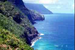
| а(MI_Metadata) ааааfileIdentifier: аgov.noaa.ngdc.mgg.photos:G01274 ааааlanguage: аeng; USA ааааcharacterSet: а(MD_CharacterSetCode)аutf8 ааааhierarchyLevel: а(MD_ScopeCode)аdataset ааааcontact: а(CI_ResponsibleParty) ааааааааorganisationName: аNOAA National Centers for Environmental Information ааааааааpositionName: аHazards Data Manager ааааааааcontactInfo: а(CI_Contact) ааааааааааааaddress: а(CI_Address) ааааааааааааааааelectronicMailAddress: аhaz.info@noaa.gov ааааааааrole: а(CI_RoleCode)аpointOfContact ааааdateStamp: а2018-09-27 ааааmetadataStandardName: аISO 19115-2 Geographic Information - Metadata - Part 2: Extensions for Imagery and Gridded Data ааааmetadataStandardVersion: аISO 19115-2:2009(E) return to top ааааidentificationInfo: а(MD_DataIdentification) ааааааааcitation: а(CI_Citation) ааааааааааааtitle: аFire vs Water: Erosional/Depositional Geology, Hawaiian Islands ааааааааааааdate: а(CI_Date) ааааааааааааааааdate: а1998 ааааааааааааааааdateType: а(CI_DateTypeCode)аpublication ааааааааааааedition: аFirst ааааааааааааidentifier: а(MD_Identifier) ааааааааааааааааcode: аDocument ааааааааааааcitedResponsibleParty: а(CI_ResponsibleParty) ааааааааааааааааorganisationName: аNOAA National Centers for Environmental Information ааааааааааааааааrole: а(CI_RoleCode)аpublisher ааааааааааааcitedResponsibleParty: а(CI_ResponsibleParty) ааааааааааааааааorganisationName: аDOC/NOAA/NESDIS/NGDC > National Geophysical Data Center, NESDIS, NOAA, U.S. Department of Commerce (comp) ааааааааааааааааrole: а(CI_RoleCode)аoriginator ааааааааааааcitedResponsibleParty: а(CI_ResponsibleParty) ааааааааааааааааorganisationName: аNational Geophysical Data Center ааааааааааааааааcontactInfo: а(CI_Contact) ааааааааааааааааааааaddress: а(CI_Address) ааааааааааааааааааааааааcity: аBoulder ааааааааааааааааааааааааadministrativeArea: аCO ааааааааааааааааrole: а(CI_RoleCode)аpublisher ааааааааааааpresentationForm: ааааааааabstract: аEven a casual, untrained observer will see evidence that opposing forces have formed the Hawaiian Islands. The massive and lofty volcanoes have been scoured, abraded, and lacerated by streams and the sea. On the oldestislands (in the northwest) the volcanic mountains have been eroded and deeply cut by canyons. Even farther north are coral reefs and atolls--all that remain of former islands. This slide set examines volcanic features and their erosion by waves, glaciers, streams, and storms. The images include dramatic examples of Hawaii's unique geology. The Erosional and Depositional Geology of the Hawaiian Islands. Even a casual, untrained observer will see evidence that opposing forces have formed the Hawaiian Islands. The massive and lofty volcanoes have been scoured, abraded, and lacerated by streams and the sea. The early Hawaiians themselves recognized this conflict between the volcanoes that built the islands and the forces that eroded them. The people created stories about two goddess sisters: Pele and Na Maka O Kaha'i. Pele, the goddess of fire was depicted as always building a new home for herself ( volcano). Na Kaka O Kaha'i, the evil goddess of the sea, continually hunted out Pele and attempted to destroy her home. This is an apt description of the geology of the islands. On the oldest islands (in the northwest), the volcanic mountains have been eroded and deeply cut by canyons. Even further north are coral reefs and atolls all that remain of former islands. The older islands show evidence of a resurgence of volcanism. The myths attribute this to Pele's attempt to fight back against the force of water that sought to destroy her homes. Scientists believe that continents and ocean basins drift, or move slowly, relative to eachother and to Earth's hot interior. The Pacific Ocean floor is drifting to the northwest over a hot spot the source of the molten material which is building the volcanic islands. While olderislands erode, new islands form to the southeast as new sections of the ocean floor move over thehot spot. On these islands, the geological features are on a grand scale. On the Big IslandHawaii), Mauna Loa and Mauna Kea rise from the ocean depths of 5,486 m (18,000 ft) to a maximum elevation above sea level of nearly 4,267 m (14,000 ft). They are among the tallest mountain masses on Earth. The islands are characterized by cliffs, or palis, some of which may have originated as the subaerial scars above giant submarine landslides. These cliffs are striking and steep, and deeply grooved as though Na MaKa O Kaha'i herself had attempted to draw more land into the sea with her long fingernails. As a new Hawaiian volcano was born on the ocean floor, pillow lava and a rubble of fragmented lava formed the submarine portion of the future island. When the volcano finally emerged above the sea, the submarine rubble and debris were covered by solid layers of lava flows. The weight of these layers pressed on the underlying weak debris. As the huge shield volcano settled under its own weight, cracks opened that permitted magma to intrude laterally and reach the surface on the flanks of the shield. Some of the cracks became planes of weakness in the underlying rubble, allowing the volcanic slopes to slide massively down and out onto the deep floor. On the emergent part of the volcano, lava flows continued to build the island, while the forces of erosion, waves, wind, rain, freshwater streams, landslides, and even glaciers carved the land and delivered sediment to the sea. Some of the larger valleys and canyons have eroded where streams took advantage of weak zones in faulted bedrock. Hawaii's beaches have many colors of sand. White sand, the most abundant, is of marine origin, derived from skeletal fragments of shallow-water marine organisms. Dark-gray detrital sand is eroded basalt, deposited mainly by streams, but also by waves. Tan sand is a mixture of the white and gray. Green sand is created as waves attack olivine-bearing cinder and tuff. Black sand commonly forms when hot lava enters the cooler ocean, fragments, and is deposited on the beach. All these features combine to give the islands of Hawaii a unique and incomparable beauty. ааааааааpurpose: аMake available Damage Photos for research and education ааааааааcredit: аPatricia Lockridge ааааааааstatus: а(MD_ProgressCode)аcompleted ааааааааpointOfContact: а(CI_ResponsibleParty) ааааааааааааorganisationName: аNOAA National Centers for Environmental Information ааааааааааааpositionName: аHazards Data Manager ааааааааааааcontactInfo: а(CI_Contact) ааааааааааааааааaddress: а(CI_Address) ааааааааааааааааааааelectronicMailAddress: аhaz.info@noaa.gov ааааааааааааrole: а(CI_RoleCode)аpointOfContact ааааааааresourceMaintenance: а(MD_MaintenanceInformation) ааааааааааааmaintenanceAndUpdateFrequency: а(MD_MaintenanceFrequencyCode)аnotPlanned ааааааааgraphicOverview: а(MD_BrowseGraphic) ааааааааааааfileName: https://www.ngdc.noaa.gov/hazard/icons/small_res/38/38_764.jpg ааааааааааааfileDescription: аThese steep cliffs are nearly 823 m (2,700 ft) high. A huge landslide may have taken place in this area several million years ago. Rubble from a giant slide is visible for miles on the ocean floor, northwest of Kauai. After the slide, the landslide scar was cut by stream erosion, and submerged in submarine canyons. The cliffs seen here are now well inland from the original, giant slide. Rock falls, chemical weathering, and erosion from small streams continue to sculpt this dramatic area. ааааааааааааfileType: аJPEG ааааааааdescriptiveKeywords: а(MD_Keywords) ааааааааааааkeyword: аEARTH SCIENCE > Land Surface > Erosion/Sedimentation > Erosion ааааааааааааkeyword: аEARTH SCIENCE > Oceans > Coastal Processes > Erosion ааааааааааааkeyword: аEARTH SCIENCE > Oceans > Marine Volcanism ааааааааааааkeyword: аEARTH SCIENCE > Solid Earth > Volcanoes ааааааааааааkeyword: аEARTH SCIENCE > Solid Earth > Volcanoes > Lava ааааааааааааtype: а(MD_KeywordTypeCode)аtheme ааааааааааааthesaurusName: а(CI_Citation) ааааааааааааааааtitle: аNASA/GCMD Earth Science Keywords ааааааааааааааааdate: (unknown) ааааааааdescriptiveKeywords: а(MD_Keywords) ааааааааааааkeyword: аoceans ааааааааааааkeyword: аgeoscientificInformation ааааааааааааtype: а(MD_KeywordTypeCode)аtheme ааааааааааааthesaurusName: а(CI_Citation) ааааааааааааааааtitle: аISO Topic Keywords ааааааааааааааааdate: (unknown) ааааааааdescriptiveKeywords: а(MD_Keywords) ааааааааааааkeyword: аICSU-WDS > International Council for Science - World Data System ааааааааааааtype: а(MD_KeywordTypeCode)аproject ааааааааааааthesaurusName: а(CI_Citation) ааааааааааааааааtitle: аGlobal Change Master Directory (GCMD) Project Keywords ааааааааааааааааdate: а(CI_Date) ааааааааааааааааааааdate: а2020-01-09 ааааааааааааааааааааdateType: а(CI_DateTypeCode)аpublication ааааааааааааааааedition: а9.1 ааааааааааааааааcitedResponsibleParty: а(CI_ResponsibleParty) ааааааааааааааааааааorganisationName: аNASA Goddard Space Flight Center, Earth Science Data and Information System ааааааааааааааааааааcontactInfo: а(CI_Contact) ааааааааааааааааааааааааonlineResource: а(CI_OnlineResource) ааааааааааааааааааааааааааааlinkage: https://www.earthdata.nasa.gov/learn/find-data/idn/gcmd-keywords ааааааааааааааааааааааааааааname: аGlobal Change Master Directory (GCMD) Keywords ааааааааааааааааааааааааааааdescription: аThe information provided on this page seeks to define how the GCMD Keywords are structured, used and accessed. It also provides information on how users can participate in the further development of the keywords. ааааааааааааааааааааааааааааfunction: а(CI_OnLineFunctionCode)аinformation ааааааааааааааааааааrole: а(CI_RoleCode)аcustodian ааааааааdescriptiveKeywords: а(MD_Keywords) ааааааааааааkeyword: аNorth and Central America > United States > Hawaii ааааааааааааtype: а(MD_KeywordTypeCode)аplace ааааааааааааthesaurusName: а(CI_Citation) ааааааааааааааааtitle: аGetty Thesaurus of Geographic Names ааааааааааааааааdate: (unknown) ааааааааdescriptiveKeywords: а(MD_Keywords) ааааааааааааkeyword: аDOC/NOAA/NESDIS/NCEI > National Centers for Environmental Information, NESDIS, NOAA, U.S. Department of Commerce ааааааааааааkeyword: аDOC/NOAA/NESDIS/NGDC > National Geophysical Data Center, NESDIS, NOAA, U.S. Department of Commerce ааааааааааааtype: а(MD_KeywordTypeCode)аdataCentre ааааааааааааthesaurusName: а(CI_Citation) ааааааааааааааааtitle: аGlobal Change Master Directory (GCMD) Data Center Keywords ааааааааааааааааdate: а(CI_Date) ааааааааааааааааааааdate: а2020-01-09 ааааааааааааааааааааdateType: а(CI_DateTypeCode)аpublication ааааааааааааааааedition: а9.1 ааааааааааааааааcitedResponsibleParty: а(CI_ResponsibleParty) ааааааааааааааааааааorganisationName: аNASA Goddard Space Flight Center, Earth Science Data and Information System ааааааааааааааааааааcontactInfo: а(CI_Contact) ааааааааааааааааааааааааonlineResource: а(CI_OnlineResource) ааааааааааааааааааааааааааааlinkage: https://www.earthdata.nasa.gov/learn/find-data/idn/gcmd-keywords ааааааааааааааааааааааааааааname: аGlobal Change Master Directory (GCMD) Keywords ааааааааааааааааааааааааааааdescription: аThe information provided on this page seeks to define how the GCMD Keywords are structured, used and accessed. It also provides information on how users can participate in the further development of the keywords. ааааааааааааааааааааааааааааfunction: а(CI_OnLineFunctionCode)аinformation ааааааааааааааааааааrole: а(CI_RoleCode)аcustodian ааааааааresourceConstraints: а(MD_LegalConstraints) ааааааааааааaccessConstraints: а(MD_RestrictionCode)аotherRestrictions ааааааааааааuseConstraints: а(MD_RestrictionCode)аotherRestrictions ааааааааааааotherConstraints: аAccess Constraints: None Use Constraints: None Distribution Liability: While every effort has been made to ensure that these data are accurate and reliable within the limits of the current state of the art, NOAA cannot assume liability for any damages caused by any errors or omissions in the data, nor as a result of the failure of the data to function on a particular system. NOAA makes no warranty, expressed or implied, nor does the fact of distribution constitute such a warranty. ааааааааlanguage: аeng; USA ааааааааextent: а(EX_Extent) ааааааааааааgeographicElement: а(EX_GeographicBoundingBox) ааааааааааааааааwestBoundLongitude: а-145 ааааааааааааааааeastBoundLongitude: а180 ааааааааааааааааsouthBoundLatitude: а18 ааааааааааааааааnorthBoundLatitude: а30 ааааааааааааtemporalElement: а(EX_TemporalExtent) ааааааааааааааааextent: ааааааааааааааааааTimeInstant: ааааааааааааааааааааdescription: аPublication Date ааааааааааааааааааааtimePosition: а1998-02-01 return to top ааааcontentInfo: return to top ааааdistributionInfo: а(MD_Distribution) ааааааааdistributionFormat: а(MD_Format) ааааааааааааname: аTIFF ааааааааааааversion: (unknown) ааааааааdistributor: а(MD_Distributor) ааааааааааааdistributorContact: а(CI_ResponsibleParty) ааааааааааааааааorganisationName: аDOC/NOAA/NESDIS/NCEI > National Centers for Environmental Information, NESDIS, NOAA, U.S. Department of Commerce ааааааааааааааааpositionName: аUser Services ааааааааааааааааcontactInfo: а(CI_Contact) ааааааааааааааааааааphone: а(CI_Telephone) ааааааааааааааааааааааааvoice: а303-497-6826 ааааааааааааааааааааааааfacsimile: а303-497-6513 ааааааааааааааааааааaddress: а(CI_Address) ааааааааааааааааааааааааdeliveryPoint: а325 Broadway ааааааааааааааааааааааааcity: аBoulder ааааааааааааааааааааааааadministrativeArea: аCO ааааааааааааааааааааааааpostalCode: а80305-3328 ааааааааааааааааааааааааcountry: аUSA ааааааааааааааааааааааааelectronicMailAddress: аngdc.info@noaa.gov ааааааааааааааааааааhoursOfService: а8am-5pm, Monday through Friday ааааааааааааааааrole: а(CI_RoleCode)аdistributor ааааааааtransferOptions: а(MD_DigitalTransferOptions) ааааааааааааtransferSize: ааааааааааааааReal: а37714 ааааааааааааonLine: а(CI_OnlineResource) ааааааааааааааааlinkage: https://www.ngdc.noaa.gov/hazardimages/ ааааааааааааonLine: а(CI_OnlineResource) ааааааааааааааааlinkage: https://www.ngdc.noaa.gov/hazard/ ааааааааtransferOptions: а(MD_DigitalTransferOptions) ааааааааааааoffLine: а(MD_Medium) ааааааааааааааааname: а(MD_MediumNameCode)аcdRom ааааааааааааааааmediumFormat: а(MD_MediumFormatCode)аiso9660 return to top ааааdataQualityInfo: а(DQ_DataQuality) ааааааааscope: а(DQ_Scope) ааааааааааааlevel: а(MD_ScopeCode)аrepository ааааааааааааlevelDescription: а(MD_ScopeDescription) ааааааааааааааааother: аNOAA National Centers for Environmental Information ааааааааlineage: а(LI_Lineage) ааааааааааааprocessStep: а(LE_ProcessStep) ааааааааааааааааdescription: аNOAA created the National Centers for Environmental Information (NCEI) by merging NOAA's National Climatic Data Center (NCDC), National Geophysical Data Center (NGDC), and National Oceanographic Data Center (NODC), including the National Coastal Data Development Center (NCDDC), per the Consolidated and Further Continuing Appropriations Act, 2015, Public Law 113-235. NCEI launched publicly on April 22, 2015. ааааааааааааааааdateTime: ааааааааааааааааааDateTime: а2015-04-22T00:00:00 return to top ааааmetadataMaintenance: а(MD_MaintenanceInformation) ааааааааmaintenanceAndUpdateFrequency: (unknown) ааааааааmaintenanceNote: аThis metadata was automatically generated from the Content Standard for Digital Geospatial Metadata: Extensions for Remote Sensing Metadata standard version FGDC-STD-012-2002 using the June 2011 version of the FGDC RSE to ISO 19115-2 transform. The Spatial Reference Information is not currently mapped over to ISO but will be mapped in future versions. ааааааааmaintenanceNote: аThis record was automatically modified on 2015-10-14 to include references to NCEI where applicable. ааааааааcontact: а(CI_ResponsibleParty) ааааааааааааorganisationName: аNOAA National Centers for Environmental Information ааааааааааааpositionName: аMetadata Specialist ааааааааааааrole: а(CI_RoleCode)аeditor ааааааааcontact: а(CI_ResponsibleParty) ааааааааааааorganisationName: аNOAA National Centers for Environmental Information ааааааааааааpositionName: аHazards Data Manager ааааааааааааcontactInfo: а(CI_Contact) ааааааааааааааааaddress: а(CI_Address) ааааааааааааааааааааelectronicMailAddress: аhaz.info@noaa.gov ааааааааааааrole: а(CI_RoleCode)аpointOfContact | |