| 1988 Spitak Earthquake Database | identificationInfo|
|---|---|
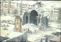
| а(MI_Metadata) ааааfileIdentifier: аgov.noaa.ngdc.mgg.hazards:G01269 ааааlanguage: аeng; USA ааааcharacterSet: а(MD_CharacterSetCode)аutf8 ааааhierarchyLevel: а(MD_ScopeCode)аdataset ааааcontact: а(CI_ResponsibleParty) ааааааааorganisationName: аNOAA National Centers for Environmental Information ааааааааpositionName: аHazards Data Manager ааааааааcontactInfo: а(CI_Contact) ааааааааааааaddress: а(CI_Address) ааааааааааааааааelectronicMailAddress: аhaz.info@noaa.gov ааааааааrole: а(CI_RoleCode)аpointOfContact ааааdateStamp: а2018-07-30 ааааmetadataStandardName: аISO 19115-2 Geographic Information - Metadata - Part 2: Extensions for Imagery and Gridded Data ааааmetadataStandardVersion: аISO 19115-2:2009(E) return to top ааааidentificationInfo: а(MD_DataIdentification) ааааааааcitation: а(CI_Citation) ааааааааааааtitle: а1988 Spitak Earthquake Database ааааааааааааdate: а(CI_Date) ааааааааааааааааdate: а1994-08-23 ааааааааааааааааdateType: а(CI_DateTypeCode)аpublication ааааааааааааedition: аFirst ааааааааааааcitedResponsibleParty: а(CI_ResponsibleParty) ааааааааааааааааorganisationName: аNOAA National Centers for Environmental Information ааааааааааааааааrole: а(CI_RoleCode)аpublisher ааааааааааааcitedResponsibleParty: а(CI_ResponsibleParty) ааааааааааааааааindividualName: аNicolas Arcos ааааааааааааааааorganisationName: аDOC/NOAA/NESDIS/NCEI > National Centers for Environmental Information, NESDIS, NOAA, U.S. Department of Commerce ааааааааааааааааcontactInfo: а(CI_Contact) ааааааааааааааааааааphone: а(CI_Telephone) ааааааааааааааааааааааааvoice: а(303) 497-3158 ааааааааааааааааааааааааfacsimile: а(303) 497-6513 ааааааааааааааааааааaddress: а(CI_Address) ааааааааааааааааааааааааdeliveryPoint: а325 Broadway, Mail Code E/NE42 ааааааааааааааааааааааааcity: аBoulder ааааааааааааааааааааааааadministrativeArea: аCO ааааааааааааааааааааааааpostalCode: а80305-3328 ааааааааааааааааааааааааcountry: аUSA ааааааааааааааааааааааааelectronicMailAddress: аhaz.info@noaa.gov ааааааааааааааааrole: а(CI_RoleCode)аpointOfContact ааааааааabstract: аThe 1988 Spitak Earthquake database is an extensive collection of geophysical and geological data, maps, charts, images and descriptive text pertaining to the catastrophic earthquake in Armenia. This earthquake was unique both in catastrophic effects and in study coverage. Research groups from the former U.S.S.R., U.S.A., France, and Japan studied the earthquake area. The database was developed as a cooperative effort between centers in Russia and the United States. The goal was to provide seismologists around the world with a complete set of data for the devastating earthquake. The database contains practically all material relevant to the 1988 Spitak earthquake and its aftereffects. It also includes the geological and geophysical information collected during the years prior to the event, important for understanding the event. Almost 2,000 files and 170 megabytes of data are contained in the collection. The database is static and is no longer being updated. ааааааааpurpose: аTo provide seismologists around the world with a complete set of data for the devastating earthquake that occurred in Spitak, Armenia on December 7, 1988. ааааааааstatus: а(MD_ProgressCode)аcompleted ааааааааpointOfContact: а(CI_ResponsibleParty) ааааааааааааindividualName: аNicolas Arcos ааааааааааааorganisationName: аDOC/NOAA/NESDIS/NCEI > National Centers for Environmental Information, NESDIS, NOAA, U.S. Department of Commerce ааааааааааааcontactInfo: а(CI_Contact) ааааааааааааааааphone: а(CI_Telephone) ааааааааааааааааааааvoice: а(303) 497-3158 ааааааааааааааааааааfacsimile: а(303) 497-6513 ааааааааааааааааaddress: а(CI_Address) ааааааааааааааааааааdeliveryPoint: а325 Broadway, Mail Code E/NE42 ааааааааааааааааааааcity: аBoulder ааааааааааааааааааааadministrativeArea: аCO ааааааааааааааааааааpostalCode: а80305-3328 ааааааааааааааааааааcountry: аUSA ааааааааааааааааааааelectronicMailAddress: аhaz.info@noaa.gov ааааааааааааrole: а(CI_RoleCode)аpointOfContact ааааааааresourceMaintenance: а(MD_MaintenanceInformation) ааааааааааааmaintenanceAndUpdateFrequency: а(MD_MaintenanceFrequencyCode)аnotPlanned ааааааааааааmaintenanceNote: аThere are no plans to update the data in this collection. ааааааааgraphicOverview: а(MD_BrowseGraphic) ааааааааааааfileName: https://www.ngdc.noaa.gov/hazard/icons/spitaksm.gif ааааааааааааfileDescription: аImage showing the collapse of an old stone masonry Armenian church near Leninakan. ааааааааааааfileType: аjpg ааааааааdescriptiveKeywords: а(MD_Keywords) ааааааааааааkeyword: аEarth Science > Solid Earth > Seismology > Earthquake Occurrences ааааааааааааtype: а(MD_KeywordTypeCode)аtheme ааааааааааааthesaurusName: а(CI_Citation) ааааааааааааааааtitle: аGlobal Change Master Directory (GCMD) Science Keywords ааааааааааааааааdate: а(CI_Date) ааааааааааааааааааааdate: а2020-01-09 ааааааааааааааааааааdateType: а(CI_DateTypeCode)аpublication ааааааааааааааааedition: а9.1 ааааааааааааааааcitedResponsibleParty: а(CI_ResponsibleParty) ааааааааааааааааааааorganisationName: аNASA Goddard Space Flight Center, Earth Science Data and Information System ааааааааааааааааааааcontactInfo: а(CI_Contact) ааааааааааааааааааааааааonlineResource: а(CI_OnlineResource) ааааааааааааааааааааааааааааlinkage: https://www.earthdata.nasa.gov/learn/find-data/idn/gcmd-keywords ааааааааааааааааааааааааааааname: аGlobal Change Master Directory (GCMD) Keywords ааааааааааааааааааааааааааааdescription: аThe information provided on this page seeks to define how the GCMD Keywords are structured, used and accessed. It also provides information on how users can participate in the further development of the keywords. ааааааааааааааааааааааааааааfunction: а(CI_OnLineFunctionCode)аinformation ааааааааааааааааааааrole: а(CI_RoleCode)аcustodian ааааааааdescriptiveKeywords: а(MD_Keywords) ааааааааааааkeyword: аINFOTERRA > Disasters > Catastrophic phenomena > Earthquakes ааааааааааааkeyword: аINFOTERRA > Lithosphere > Seismic activity > Seismic activity ааааааааааааkeyword: аINFOTERRA > Lithosphere > Seismic monitoring > Seismic monitoring ааааааааааааtype: а(MD_KeywordTypeCode)аtheme ааааааааааааthesaurusName: а(CI_Citation) ааааааааааааааааtitle: аINFOTERRA Keyword Thesaurus ааааааааааааааааdate: (unknown) ааааааааdescriptiveKeywords: а(MD_Keywords) ааааааааааааkeyword: аEpicenter ааааааааааааkeyword: аHypocenter ааааааааааааtype: а(MD_KeywordTypeCode)аtheme ааааааааааааthesaurusName: а(CI_Citation) ааааааааааааааааtitle: аUncontrolled Keywords ааааааааааааааааdate: (unknown) ааааааааdescriptiveKeywords: а(MD_Keywords) ааааааааааааkeyword: аSeismographs ааааааааааааkeyword: аSeismometers ааааааааааааkeyword: аVisual Observations ааааааааааааtype: а(MD_KeywordTypeCode)аinstrument ааааааааааааthesaurusName: а(CI_Citation) ааааааааааааааааtitle: аGlobal Change Master Directory (GCMD) Instrument Keywords ааааааааааааааааdate: а(CI_Date) ааааааааааааааааааааdate: а2020-01-09 ааааааааааааааааааааdateType: а(CI_DateTypeCode)аpublication ааааааааааааааааedition: а9.1 ааааааааааааааааcitedResponsibleParty: а(CI_ResponsibleParty) ааааааааааааааааааааorganisationName: аNASA Goddard Space Flight Center, Earth Science Data and Information System ааааааааааааааааааааcontactInfo: а(CI_Contact) ааааааааааааааааааааааааonlineResource: а(CI_OnlineResource) ааааааааааааааааааааааааааааlinkage: https://www.earthdata.nasa.gov/learn/find-data/idn/gcmd-keywords ааааааааааааааааааааааааааааname: аGlobal Change Master Directory (GCMD) Keywords ааааааааааааааааааааааааааааdescription: аThe information provided on this page seeks to define how the GCMD Keywords are structured, used and accessed. It also provides information on how users can participate in the further development of the keywords. ааааааааааааааааааааааааааааfunction: а(CI_OnLineFunctionCode)аinformation ааааааааааааааааааааrole: а(CI_RoleCode)аcustodian ааааааааdescriptiveKeywords: а(MD_Keywords) ааааааааааааkeyword: аICSU-WDS > International Council for Science - World Data System ааааааааааааtype: а(MD_KeywordTypeCode)аproject ааааааааааааthesaurusName: а(CI_Citation) ааааааааааааааааtitle: аGlobal Change Master Directory (GCMD) Project Keywords ааааааааааааааааdate: а(CI_Date) ааааааааааааааааааааdate: а2020-01-09 ааааааааааааааааааааdateType: а(CI_DateTypeCode)аpublication ааааааааааааааааedition: а9.1 ааааааааааааааааcitedResponsibleParty: а(CI_ResponsibleParty) ааааааааааааааааааааorganisationName: аNASA Goddard Space Flight Center, Earth Science Data and Information System ааааааааааааааааааааcontactInfo: а(CI_Contact) ааааааааааааааааааааааааonlineResource: а(CI_OnlineResource) ааааааааааааааааааааааааааааlinkage: https://www.earthdata.nasa.gov/learn/find-data/idn/gcmd-keywords ааааааааааааааааааааааааааааname: аGlobal Change Master Directory (GCMD) Keywords ааааааааааааааааааааааааааааdescription: аThe information provided on this page seeks to define how the GCMD Keywords are structured, used and accessed. It also provides information on how users can participate in the further development of the keywords. ааааааааааааааааааааааааааааfunction: а(CI_OnLineFunctionCode)аinformation ааааааааааааааааааааrole: а(CI_RoleCode)аcustodian ааааааааdescriptiveKeywords: а(MD_Keywords) ааааааааааааkeyword: аAsia > Armenia > Spitak ааааааааааааtype: а(MD_KeywordTypeCode)аplace ааааааааааааthesaurusName: а(CI_Citation) ааааааааааааааааtitle: аGetty Thesaurus of Geographic Names ааааааааааааааааdate: (unknown) ааааааааdescriptiveKeywords: а(MD_Keywords) ааааааааааааkeyword: аContinent > Asia > Western Asia > Armenia ааааааааааааtype: а(MD_KeywordTypeCode)аplace ааааааааааааthesaurusName: а(CI_Citation) ааааааааааааааааtitle: аGlobal Change Master Directory (GCMD) Location Keywords ааааааааааааааааdate: а(CI_Date) ааааааааааааааааааааdate: а2020-01-09 ааааааааааааааааааааdateType: а(CI_DateTypeCode)аpublication ааааааааааааааааedition: а9.1 ааааааааааааааааcitedResponsibleParty: а(CI_ResponsibleParty) ааааааааааааааааааааorganisationName: аNASA Goddard Space Flight Center, Earth Science Data and Information System ааааааааааааааааааааcontactInfo: а(CI_Contact) ааааааааааааааааааааааааonlineResource: а(CI_OnlineResource) ааааааааааааааааааааааааааааlinkage: https://www.earthdata.nasa.gov/learn/find-data/idn/gcmd-keywords ааааааааааааааааааааааааааааname: аGlobal Change Master Directory (GCMD) Keywords ааааааааааааааааааааааааааааdescription: аThe information provided on this page seeks to define how the GCMD Keywords are structured, used and accessed. It also provides information on how users can participate in the further development of the keywords. ааааааааааааааааааааааааааааfunction: а(CI_OnLineFunctionCode)аinformation ааааааааааааааааааааrole: а(CI_RoleCode)аcustodian ааааааааdescriptiveKeywords: а(MD_Keywords) ааааааааааааkeyword: аDOC/NOAA/NESDIS/NCEI > National Centers for Environmental Information, NESDIS, NOAA, U.S. Department of Commerce ааааааааааааkeyword: аDOC/NOAA/NESDIS/NGDC > National Geophysical Data Center, NESDIS, NOAA, U.S. Department of Commerce ааааааааааааtype: а(MD_KeywordTypeCode)аdataCentre ааааааааааааthesaurusName: а(CI_Citation) ааааааааааааааааtitle: аGlobal Change Master Directory (GCMD) Data Center Keywords ааааааааааааааааdate: а(CI_Date) ааааааааааааааааааааdate: а2020-01-09 ааааааааааааааааааааdateType: а(CI_DateTypeCode)аpublication ааааааааааааааааedition: а9.1 ааааааааааааааааcitedResponsibleParty: а(CI_ResponsibleParty) ааааааааааааааааааааorganisationName: аNASA Goddard Space Flight Center, Earth Science Data and Information System ааааааааааааааааааааcontactInfo: а(CI_Contact) ааааааааааааааааааааааааonlineResource: а(CI_OnlineResource) ааааааааааааааааааааааааааааlinkage: https://www.earthdata.nasa.gov/learn/find-data/idn/gcmd-keywords ааааааааааааааааааааааааааааname: аGlobal Change Master Directory (GCMD) Keywords ааааааааааааааааааааааааааааdescription: аThe information provided on this page seeks to define how the GCMD Keywords are structured, used and accessed. It also provides information on how users can participate in the further development of the keywords. ааааааааааааааааааааааааааааfunction: а(CI_OnLineFunctionCode)аinformation ааааааааааааааааааааrole: а(CI_RoleCode)аcustodian ааааааааresourceConstraints: а(MD_Constraints) ааааааааааааuseLimitation: аProduced by the NOAA National Centers for Environmental Information. Not subject to copyright protection within the United States. ааааааааresourceConstraints: а(MD_LegalConstraints) ааааааааааааaccessConstraints: а(MD_RestrictionCode)аotherRestrictions ааааааааааааotherConstraints: аDistribution liability: NOAA and NCEI make no warranty, expressed or implied, regarding these data, nor does the fact of distribution constitute such a warranty. NOAA and NCEI cannot assume liability for any damages caused by any errors or omissions in these data. If appropriate, NCEI can only certify that the data it distributes are an authentic copy of the records that were accepted for inclusion in the NCEI archives. ааааааааlanguage: аeng; USA ааааааааtopicCategory: а(MD_TopicCategoryCode)аgeoscientificInformation ааааааааextent: а(EX_Extent) ааааааааааааgeographicElement: а(EX_GeographicBoundingBox) ааааааааааааааааwestBoundLongitude: а42.000000 ааааааааааааааааeastBoundLongitude: а48.000000 ааааааааааааааааsouthBoundLatitude: а40.000000 ааааааааааааааааnorthBoundLatitude: а43.000000 ааааааааааааtemporalElement: а(EX_TemporalExtent) ааааааааааааааааextent: ааааааааааааааааааTimePeriod: ааааааааааааааааааааbeginPosition: а1988-12-07 ааааааааааааааааааааendPosition: а1988-12-07 return to top ааааdistributionInfo: а(MD_Distribution) ааааааааdistributionFormat: а(MD_Format) ааааааааааааname: аASCII ааааааааааааversion: (unknown) ааааааааdistributionFormat: а(MD_Format) ааааааааааааname: аpcx ааааааааааааversion: (unknown) ааааааааdistributionFormat: а(MD_Format) ааааааааааааname: аdbase ааааааааааааversion: (unknown) ааааааааdistributor: а(MD_Distributor) ааааааааааааdistributorContact: а(CI_ResponsibleParty) ааааааааааааааааorganisationName: аNOAA National Centers for Environmental Information ааааааааааааааааpositionName: аHazards Data Manager ааааааааааааааааcontactInfo: а(CI_Contact) ааааааааааааааааааааaddress: а(CI_Address) ааааааааааааааааааааааааelectronicMailAddress: аhaz.info@noaa.gov ааааааааааааааааrole: а(CI_RoleCode)аpointOfContact ааааааааааааdistributionOrderProcess: а(MD_StandardOrderProcess) ааааааааааааааааfees: аFree on the web ааааааааtransferOptions: а(MD_DigitalTransferOptions) ааааааааааааonLine: а(CI_OnlineResource) ааааааааааааааааlinkage: https://www.ngdc.noaa.gov/hazard/fliers/se-0207.shtml ааааааааааааааааprotocol: аhttp ааааааааааааааааname: аSpitak Earthquake, 1988 ааааааааааааааааdescription: аThis set consists of textual and graphical information about the 1988 Spitak earthquake, a "DOS" and "Microsoft Windows" menu for accessing the data, and a User Manual which discusses the data and explains how to use the access software to display and obtain useful information. The database is static and is no longer being updated. ааааааааааааааааfunction: а(CI_OnLineFunctionCode)аdownload return to top ааааdataQualityInfo: а(DQ_DataQuality) ааааааааscope: а(DQ_Scope) ааааааааааааlevel: а(MD_ScopeCode)аdataset ааааааааlineage: а(LI_Lineage) ааааааааааааstatement: аThis is a collection of data related to the 1988 Spitak earthquake that was released by the Russian Academy of Sciences National Geophysical Committee Geophysical Center and NOAA National Geophysical Data Center (NGDC). It was a demonstration project to provide access to different types of geophysical data all related to one event, e.g. seismicity data, isoseismal maps, seismic zoning maps, earthquake strong motion data, images showing damage. The data were formatted to be accessed with the NGDC-developed GeoVu software. ааааааааааааprocessStep: а(LI_ProcessStep) ааааааааааааааааdescription: аThe data from the 1988 Spitak earthquake were released by the Russian Academy of Sciences National Geophysical Committee Geophysical Center and NOAA National Geophysical Data Center (NGDC). ааааааааааааааааprocessor: а(CI_ResponsibleParty) ааааааааааааааааааааindividualName: аNatural Hazards Data Manager ааааааааааааааааааааorganisationName: аDOC/NOAA/NESDIS/NCEI > National Centers for Environmental Information, NESDIS, NOAA, U.S. Department of Commerce ааааааааааааааааааааrole: а(CI_RoleCode)аcustodian ааааааааааааsource: а(LI_Source) ааааааааааааааааdescription: аResearch groups from the former U.S.S.R., U.S.A., France, and Japan studied the earthquake area and contributed to this collection. return to top ааааdataQualityInfo: а(DQ_DataQuality) ааааааааscope: а(DQ_Scope) ааааааааааааlevel: а(MD_ScopeCode)аdataset ааааааааreport: а(DQ_CompletenessCommission) ааааааааааааevaluationMethodDescription: аThe data are of high quality and complete for this event. ааааааааааааresult: (unknown) return to top ааааdataQualityInfo: а(DQ_DataQuality) ааааааааscope: а(DQ_Scope) ааааааааааааlevel: а(MD_ScopeCode)аrepository ааааааааааааlevelDescription: а(MD_ScopeDescription) ааааааааааааааааother: аNOAA National Centers for Environmental Information ааааааааlineage: а(LI_Lineage) ааааааааааааprocessStep: а(LE_ProcessStep) ааааааааааааааааdescription: аNOAA created the National Centers for Environmental Information (NCEI) by merging NOAA's National Climatic Data Center (NCDC), National Geophysical Data Center (NGDC), and National Oceanographic Data Center (NODC), including the National Coastal Data Development Center (NCDDC), per the Consolidated and Further Continuing Appropriations Act, 2015, Public Law 113-235. NCEI launched publicly on April 22, 2015. ааааааааааааааааdateTime: ааааааааааааааааааDateTime: а2015-04-22T00:00:00 return to top ааааmetadataMaintenance: а(MD_MaintenanceInformation) ааааааааmaintenanceAndUpdateFrequency: а(MD_MaintenanceFrequencyCode)аunknown ааааааааmaintenanceNote: аThis record was automatically modified on 2015-10-01 to include references to NCEI where applicable. ааааааааcontact: а(CI_ResponsibleParty) ааааааааааааorganisationName: аNOAA National Centers for Environmental Information ааааааааааааpositionName: аMetadata Specialist ааааааааааааrole: а(CI_RoleCode)аeditor | |