 |
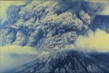
Volcanic ash is a significant hazard to aviation and can also affect global climate
patterns. To ensure safe navigation and monitor possible climatic impact, the NOAA
Satellite Services Division (SSD) tracks volcanic ash eruptions throughout the world.
After an eruption, SSD issues a Volcanic Ash Advisory (VAA) message and a forecast
of ash location in the atmosphere from the Volcanic Ash Forecast Transport and Dispersion
(VAFTAD) model. The Volcanic Ash Advisory Database contains VAA messages, VAFTAD model
output, and substantiating information from 1983 to 2003, that have been scanned into
image format. The substantiating information includes surface weather observations,
pilot reports, volcanic observatory reports, news media reports, and satellite imagery
for each event. This database is static and is no longer being updated by NCEI. |