Synoptic Maps Composites Observed from Wilcox Observatory
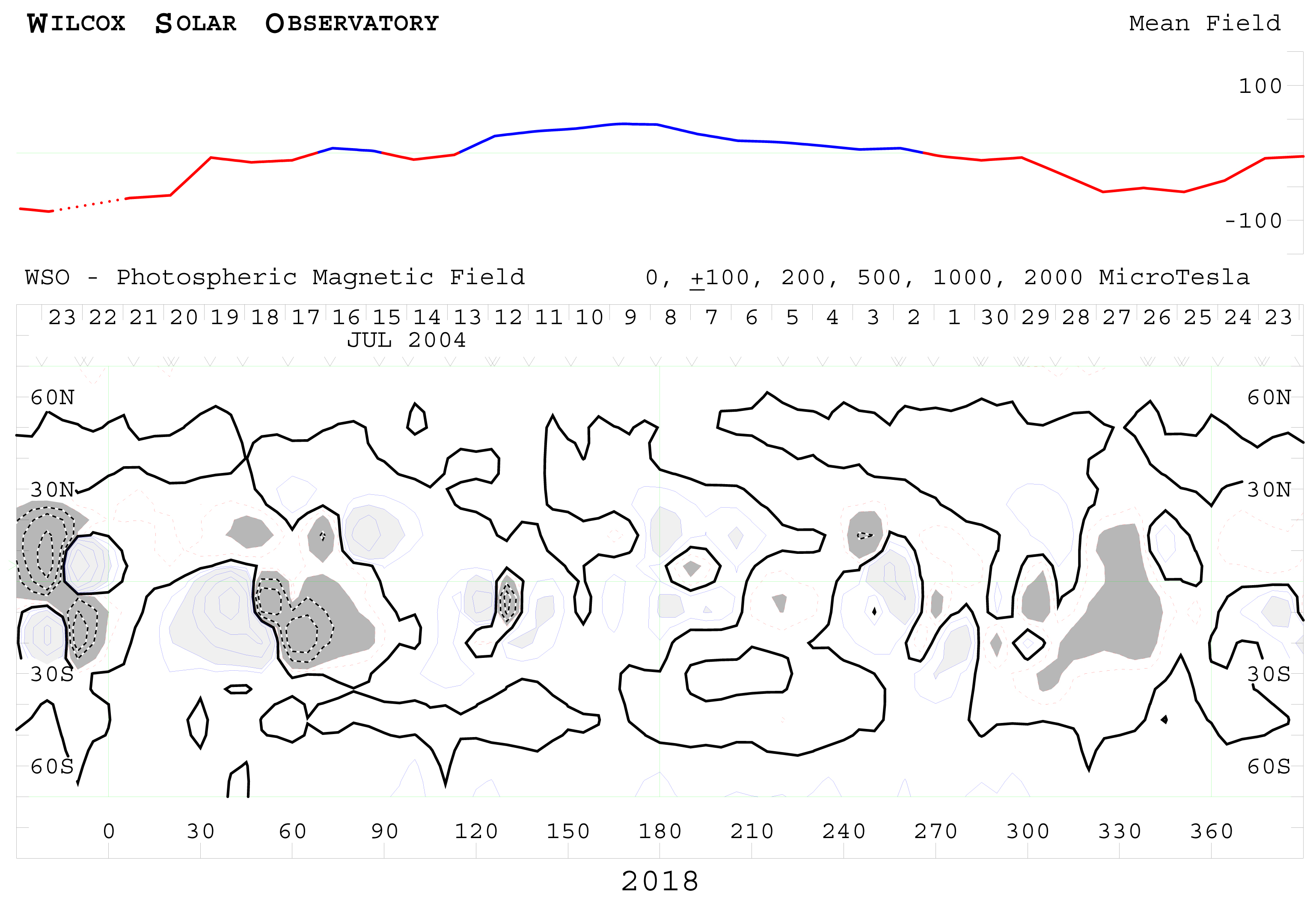 Example Image from Composites_Synoptic Maps_Wilcox series.
Solar synoptic maps usually refer to assembled composites recorded over a full solar
rotation of about 27 days. Synoptic maps can be derived from single wavelength images
or from multi-wavelength images highlighting solar features of interest (see above).
Images for this dataset were provided by numerous solar observatories. The Boulder
H-alpha (6563 A) synoptic maps, or charts, were first developed by McIntosh as an
outgrowth of efforts to infer solar magnetic fields. These McIntosh synoptic charts
identify regions of positive and negative magnetic polarity separated by a magnetic
neutral line. Superposed on many of the maps are the locations of coronal holes observed
in X-rays and from HeI spectro-heliograms at 10830 A. Features of interest evident
at various wavelengths include; 3934 A (Calcium, Ca II K-line) � used to monitor structures
in the lower chromosphere, in particular faculae which are clearly discerned in Ca
II but less so in white-light images (only near the limb) and not in H-alpha 5303
A (Iron, Fe XIV) � Monitor the chromosphere 5694 A (Calcium, Ca XV) � Ca XV emissions
from the sun are used to detect coronal hot spots. Also referred to as the solar yellow
line 6374 A (Iron, FE X) � Monitor the chromosphere 6563 A (Hydrogen, H-alpha); chromospheric
imaging of solar flares, sunspots, plage, filaments and prominences, also chromospheric
network 10830 A (Helium, He I); preferred wavelength to image coronal holes which
are not as readily apparent in Ca II and H-alpha
Cite this dataset when used as a source.
- Composites_Synoptic Maps_Wilcox
gov.noaa.ngdc.stp.solar_imagery:Composites_Synoptic_Maps_Wilcox
| Download Data |
|
| Distribution Formats |
|
| Distributor | William Denig DOC/NOAA/NESDIS/NCEI > National Centers for Environmental Information, NESDIS, NOAA, U.S. Department of Commerce (303) 497-6323 solar.ngdc@noaa.gov |
| Dataset Point of Contact | William Denig DOC/NOAA/NESDIS/NCEI > National Centers for Environmental Information, NESDIS, NOAA, U.S. Department of Commerce (303) 497-6323 solar.ngdc@noaa.gov |
| Coverage Description | Non-geographic |
| Time Period | 1999-08-18 to 2010-10-30 |
| Spatial Bounding Box Coordinates | Non-geographic |
| Documentation links not available. | |
| Publication Dates |
|
| Data Presentation Form | Digital document - digital representation of a primarily textual item (can contain
illustrations also) |
| Dataset Progress Status | Complete |
| Data Update Frequency | |
| Supplemental Information |
The NOAA National Centers for Environmental Information (formally NGDC) provides scientific
data stewardship of solar-terrestrial datasets
in compliance with NOAA Administrative Order (NAO 212-15), "Management of Environmental Data and Information", published 04 Nov 10. Scientific Data Stewardship includes the Archive, Access, and Assessment (AAA) of operational and related solar and space environmental datasets. |
| Purpose | Scientific data stewardship of solar-terrestrial datasets in compliance with NOAA Administrative Order (NAO) 212-12, "Management of Environmental and Geospatial Data and Information", dated 04 Nov 10. Scientific Data Stewardship includes the Archive, Access, and Assessment (AAA) of operational and related solar and space environmental datasets. |
| Publishers |
|
| Theme keywords | Global Change Master Directory (GCMD) Science Keywords
|
| Data Center keywords | Global Change Master Directory (GCMD) Data Center Keywords
|
| Platform keywords | Global Change Master Directory (GCMD) Platform Keywords
|
| Instrument keywords | Global Change Master Directory (GCMD) Instrument Keywords
|
| Place keywords | Global Change Master Directory (GCMD) Location Keywords
|
| Project keywords | Global Change Master Directory (GCMD) Project Keywords
|
| Use Constraints | No constraint information available |
| Access Constraints |
|
| Fees | Fee information not available. |
| Instrument |
|
| Platform |
|
Last Modified: 2016-12-27
For questions about the information on this page, please email:Karen.E.Horan@noaa.gov