| Archive of NOAA Continuously Operating Reference Stations (CORS) Network (NCN) | identificationInfo|
|---|---|
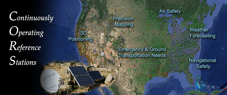
| а(MI_Metadata) ааааfileIdentifier: аgov.noaa.ngdc.stp.terrestrial:G10019 ааааlanguage: аeng; USA ааааcharacterSet: а(MD_CharacterSetCode)аutf8 ааааhierarchyLevel: а(MD_ScopeCode)аseries ааааcontact: а(CI_ResponsibleParty) ааааааааorganisationName: аNOAA National Centers for Environmental Information ааааааааcontactInfo: а(CI_Contact) ааааааааааааaddress: а(CI_Address) ааааааааааааааааelectronicMailAddress: аncei.info@noaa.gov ааааааааааааonlineResource: а(CI_OnlineResource) ааааааааааааааааlinkage: https://www.ncei.noaa.gov/contact ааааааааааааааааname: аNCEI Contact Information ааааааааааааааааdescription: аInformation for contacts at NCEI. ааааааааааааааааfunction: а(CI_OnLineFunctionCode)аinformation ааааааааrole: а(CI_RoleCode)аpointOfContact ааааdateStamp: а2023-09-14 ааааmetadataStandardName: аISO 19115-2 Geographic Information - Metadata - Part 2: Extensions for Imagery and Gridded Data ааааmetadataStandardVersion: аISO 19115-2:2009(E) return to top ааааidentificationInfo: а(MD_DataIdentification) ааааааааcitation: а(CI_Citation) ааааааааааааtitle: аArchive of NOAA Continuously Operating Reference Stations (CORS) Network (NCN) ааааааааааааdate: а(CI_Date) ааааааааааааааааdate: а1994-04-22 ааааааааааааааааdateType: а(CI_DateTypeCode)аpublication ааааааааааааidentifier: а(MD_Identifier) ааааааааааааааааauthority: а(CI_Citation) ааааааааааааааааааааtitle: аInternational DOI Foundation (IDF) ааааааааааааааааааааdate: (inapplicable) ааааааааааааааааcode: ааааааааааааааааааAnchor: аDOIа10.25921/wc4r-ee36 ааааааааааааidentifier: а(MD_Identifier) ааааааааааааааааauthority: а(CI_Citation) ааааааааааааааааааааtitle: аNOAA National Centers for Environmental Information ааааааааааааааааааааdate: (inapplicable) ааааааааааааааааcode: аNCEI Metadata ID: gov.noaa.ngdc.stp.terrestrial:G10019 ааааааааааааcitedResponsibleParty: а(CI_ResponsibleParty) ааааааааааааааааorganisationName: аNOAA National Centers for Environmental Information ааааааааааааааааrole: а(CI_RoleCode)аpublisher ааааааааааааcitedResponsibleParty: а(CI_ResponsibleParty) ааааааааааааааааorganisationName: аNOAA National Geodetic Survey (NGS) ааааааааааааааааrole: а(CI_RoleCode)аauthor ааааааааabstract: аThe National Geodetic Survey's (NGS) NOAA Continuously Operating Reference Stations (CORS) Network (NCN) provides Global Navigation Satellite System (GNSS) data consisting of carrier phase and code range measurements in support of three dimensional positioning, meteorology, space weather, and geophysical applications throughout the United States, its territories, and a few foreign countries. Surveyors, GIS users, engineers, scientists, and the public at large that collect GPS data can use CORS data to improve the precision of their positions. CORS enhanced post-processed coordinates approach a few centimeters relative to the National Spatial Reference System (NSRS), both horizontally and vertically. The CORS network is a multi-purpose cooperative endeavor involving government, academic, and private organizations. The sites are independently owned and operated. Each agency shares their data with NGS, and NGS in turn analyzes and distributes the data free of charge. ааааааааpurpose: аThe CORS data set enables users to attain centimeter-level positioning for points of interest and can be used to measure crustal motion, moisture content for the lower atmosphere, and total electronic content in the upper atmosphere. NGS publishes coordinates for CORS in several reference frames. This includes the current global reference frame from the International GNSS Service (IGS), and with respect to the National Spatial Reference System (NSRS) realizations of the North American Datum of 1983 (NAD 83) as defined by NGS. ааааааааcredit: аNGS coordinates a network of CORS stations from approximately 200 organizations such as federal, state, and local governments, academia, the private sector, and international groups. ааааааааstatus: а(MD_ProgressCode)аongoing ааааааааpointOfContact: а(CI_ResponsibleParty) ааааааааааааorganisationName: аNOAA National Centers for Environmental Information ааааааааааааcontactInfo: а(CI_Contact) ааааааааааааааааaddress: а(CI_Address) ааааааааааааааааааааelectronicMailAddress: аncei.info@noaa.gov ааааааааааааааааonlineResource: а(CI_OnlineResource) ааааааааааааааааааааlinkage: https://www.ncei.noaa.gov/contact ааааааааааааааааааааname: аNCEI Contact Information ааааааааааааааааааааdescription: аInformation for contacts at NCEI. ааааааааааааааааааааfunction: а(CI_OnLineFunctionCode)аinformation ааааааааааааrole: а(CI_RoleCode)аpointOfContact ааааааааpointOfContact: а(CI_ResponsibleParty) ааааааааааааorganisationName: аFrancine Coloma ааааааааааааcontactInfo: а(CI_Contact) ааааааааааааааааphone: а(CI_Telephone) ааааааааааааааааааааvoice: а(303) 497-3692 ааааааааааааааааaddress: а(CI_Address) ааааааааааааааааааааdeliveryPoint: а325 Broadway St ааааааааааааааааааааcity: аBoulder ааааааааааааааааааааadministrativeArea: аCO ааааааааааааааааааааpostalCode: а80027 ааааааааааааааааааааcountry: аUSA ааааааааааааааааааааelectronicMailAddress: аngs.cors@noaa.gov ааааааааааааааааhoursOfService: а9:00 - 4:00 Mountain ааааааааааааrole: а(CI_RoleCode)аpointOfContact ааааааааresourceMaintenance: а(MD_MaintenanceInformation) ааааааааааааmaintenanceAndUpdateFrequency: а(MD_MaintenanceFrequencyCode)аdaily ааааааааgraphicOverview: а(MD_BrowseGraphic) ааааааааааааfileName: https://www.ngdc.noaa.gov/image/cors_main765x320.jpg ааааааааааааfileDescription: аNCEI Archive of NGS CORS data ааааааааdescriptiveKeywords: а(MD_Keywords) ааааааааааааkeyword: аEARTH SCIENCE > Solid Earth > Geodetics ааааааааааааkeyword: аEARTH SCIENCE > Solid Earth > Geodetics > Coordinate Reference Systems ааааааааааааkeyword: аEARTH SCIENCE > Solid Earth > Geodetics > Coordinate Reference Systems > Country/Regional Coordinate Reference System ааааааааааааkeyword: аEARTH SCIENCE > Solid Earth > Geodetics > Coordinate Reference Systems > Global Coordinate Reference System ааааааааааааkeyword: аEARTH SCIENCE > Solid Earth > Geodetics > Ellipsoid Characteristics ааааааааааааkeyword: аEARTH SCIENCE > Solid Earth > Geodetics > Geoid Characteristics ааааааааааааkeyword: аEARTH SCIENCE > Solid Earth > Geodetics > Control Surveys ааааааааааааkeyword: аEARTH SCIENCE > Solid Earth > Geodetics > Crustal Motion ааааааааааааkeyword: аEARTH SCIENCE > Solid Earth > Geomorphic Landforms/Processes ааааааааааааkeyword: аEARTH SCIENCE > Solid Earth > Gravity/Gravitational Field ааааааааааааtype: а(MD_KeywordTypeCode)аtheme ааааааааааааthesaurusName: а(CI_Citation) ааааааааааааааааtitle: аGlobal Change Master Directory (GCMD) Science Keywords ааааааааааааааааdate: а(CI_Date) ааааааааааааааааааааdate: а2020-01-09 ааааааааааааааааааааdateType: а(CI_DateTypeCode)аpublication ааааааааааааааааedition: а9.1 ааааааааааааааааcitedResponsibleParty: а(CI_ResponsibleParty) ааааааааааааааааааааorganisationName: аNASA Goddard Space Flight Center, Earth Science Data and Information System ааааааааааааааааааааcontactInfo: а(CI_Contact) ааааааааааааааааааааааааonlineResource: а(CI_OnlineResource) ааааааааааааааааааааааааааааlinkage: https://www.earthdata.nasa.gov/learn/find-data/idn/gcmd-keywords ааааааааааааааааааааааааааааname: аGlobal Change Master Directory (GCMD) Keywords ааааааааааааааааааааааааааааdescription: аThe information provided on this page seeks to define how the GCMD Keywords are structured, used and accessed. It also provides information on how users can participate in the further development of the keywords. ааааааааааааааааааааааааааааfunction: а(CI_OnLineFunctionCode)аinformation ааааааааааааааааааааrole: а(CI_RoleCode)аcustodian ааааааааdescriptiveKeywords: а(MD_Keywords) ааааааааааааkeyword: аNOAA > National Geodetic Survey (NGS) > Continuously Operating Reference Station (CORS) ааааааааааааtype: а(MD_KeywordTypeCode)аproject ааааааааааааthesaurusName: а(CI_Citation) ааааааааааааааааtitle: аGlobal Change Master Directory (GCMD) Project Keywords ааааааааааааааааdate: а(CI_Date) ааааааааааааааааааааdate: а2020-01-09 ааааааааааааааааааааdateType: а(CI_DateTypeCode)аpublication ааааааааааааааааedition: а9.1 ааааааааааааааааcitedResponsibleParty: а(CI_ResponsibleParty) ааааааааааааааааааааorganisationName: аNASA Goddard Space Flight Center, Earth Science Data and Information System ааааааааааааааааааааcontactInfo: а(CI_Contact) ааааааааааааааааааааааааonlineResource: а(CI_OnlineResource) ааааааааааааааааааааааааааааlinkage: https://www.earthdata.nasa.gov/learn/find-data/idn/gcmd-keywords ааааааааааааааааааааааааааааname: аGlobal Change Master Directory (GCMD) Keywords ааааааааааааааааааааааааааааdescription: аThe information provided on this page seeks to define how the GCMD Keywords are structured, used and accessed. It also provides information on how users can participate in the further development of the keywords. ааааааааааааааааааааааааааааfunction: а(CI_OnLineFunctionCode)аinformation ааааааааааааааааааааrole: а(CI_RoleCode)аcustodian ааааааааdescriptiveKeywords: а(MD_Keywords) ааааааааааааkeyword: аGPS > Global Positioning System Satellites ааааааааааааkeyword: аNAVSTAR > NAVSTAR Global Positioning System ааааааааааааkeyword: аGLONASS > GLObalnaya NAvigatsionnaya Sputnikovaya Sistema ааааааааааааkeyword: аGNSS > Global Navigation Satellite System ааааааааааааtype: а(MD_KeywordTypeCode)аplatform ааааааааааааthesaurusName: а(CI_Citation) ааааааааааааааааtitle: аGlobal Change Master Directory (GCMD) Platform Keywords ааааааааааааааааdate: а(CI_Date) ааааааааааааааааааааdate: а2020-01-09 ааааааааааааааааааааdateType: а(CI_DateTypeCode)аpublication ааааааааааааааааedition: а9.1 ааааааааааааааааcitedResponsibleParty: а(CI_ResponsibleParty) ааааааааааааааааааааorganisationName: аNASA Goddard Space Flight Center, Earth Science Data and Information System ааааааааааааааааааааcontactInfo: а(CI_Contact) ааааааааааааааааааааааааonlineResource: а(CI_OnlineResource) ааааааааааааааааааааааааааааlinkage: https://www.earthdata.nasa.gov/learn/find-data/idn/gcmd-keywords ааааааааааааааааааааааааааааname: аGlobal Change Master Directory (GCMD) Keywords ааааааааааааааааааааааааааааdescription: аThe information provided on this page seeks to define how the GCMD Keywords are structured, used and accessed. It also provides information on how users can participate in the further development of the keywords. ааааааааааааааааааааааааааааfunction: а(CI_OnLineFunctionCode)аinformation ааааааааааааааааааааrole: а(CI_RoleCode)аcustodian ааааааааdescriptiveKeywords: а(MD_Keywords) ааааааааааааkeyword: аEarth Remote Sensing Instruments > Passive Remote Sensing > Positioning/Navigation > GPS > GPS Receivers ааааааааааааkeyword: аEarth Remote Sensing Instruments > Passive Remote Sensing > Positioning/Navigation > GPS > GNSS Receivers ааааааааааааtype: а(MD_KeywordTypeCode)аinstrument ааааааааааааthesaurusName: а(CI_Citation) ааааааааааааааааtitle: аGlobal Change Master Directory (GCMD) Instrument Keywords ааааааааааааааааdate: а(CI_Date) ааааааааааааааааааааdate: а2020-01-09 ааааааааааааааааааааdateType: а(CI_DateTypeCode)аpublication ааааааааааааааааedition: а9.1 ааааааааааааааааcitedResponsibleParty: а(CI_ResponsibleParty) ааааааааааааааааааааorganisationName: аNASA Goddard Space Flight Center, Earth Science Data and Information System ааааааааааааааааааааcontactInfo: а(CI_Contact) ааааааааааааааааааааааааonlineResource: а(CI_OnlineResource) ааааааааааааааааааааааааааааlinkage: https://www.earthdata.nasa.gov/learn/find-data/idn/gcmd-keywords ааааааааааааааааааааааааааааname: аGlobal Change Master Directory (GCMD) Keywords ааааааааааааааааааааааааааааdescription: аThe information provided on this page seeks to define how the GCMD Keywords are structured, used and accessed. It also provides information on how users can participate in the further development of the keywords. ааааааааааааааааааааааааааааfunction: а(CI_OnLineFunctionCode)аinformation ааааааааааааааааааааrole: а(CI_RoleCode)аcustodian ааааааааdescriptiveKeywords: а(MD_Keywords) ааааааааааааkeyword: аDOC/NOAA/NESDIS/NCEI > National Centers for Environmental Information, NESDIS, NOAA, U.S. Department of Commerce ааааааааааааkeyword: аDOC/NOAA/NESDIS/NGDC > National Geophysical Data Center, NESDIS, NOAA, U.S. Department of Commerce ааааааааааааtype: а(MD_KeywordTypeCode)аdataCentre ааааааааааааthesaurusName: а(CI_Citation) ааааааааааааааааtitle: аGlobal Change Master Directory (GCMD) Data Center Keywords ааааааааааааааааdate: а(CI_Date) ааааааааааааааааааааdate: а2020-01-09 ааааааааааааааааааааdateType: а(CI_DateTypeCode)аpublication ааааааааааааааааedition: а9.1 ааааааааааааааааcitedResponsibleParty: а(CI_ResponsibleParty) ааааааааааааааааааааorganisationName: аNASA Goddard Space Flight Center, Earth Science Data and Information System ааааааааааааааааааааcontactInfo: а(CI_Contact) ааааааааааааааааааааааааonlineResource: а(CI_OnlineResource) ааааааааааааааааааааааааааааlinkage: https://www.earthdata.nasa.gov/learn/find-data/idn/gcmd-keywords ааааааааааааааааааааааааааааname: аGlobal Change Master Directory (GCMD) Keywords ааааааааааааааааааааааааааааdescription: аThe information provided on this page seeks to define how the GCMD Keywords are structured, used and accessed. It also provides information on how users can participate in the further development of the keywords. ааааааааааааааааааааааааааааfunction: а(CI_OnLineFunctionCode)аinformation ааааааааааааааааааааrole: а(CI_RoleCode)аcustodian ааааааааdescriptiveKeywords: а(MD_Keywords) ааааааааааааkeyword: аGeodetic/Global Positioning ааааааааааааtype: а(MD_KeywordTypeCode)аtheme ааааааааааааthesaurusName: а(CI_Citation) ааааааааааааааааtitle: аNOS Data Explorer Themes ааааааааааааааааdate: (unknown) ааааааааdescriptiveKeywords: а(MD_Keywords) ааааааааааааkeyword: аUnited States ааааааааааааtype: а(MD_KeywordTypeCode)аplace ааааааааааааthesaurusName: а(CI_Citation) ааааааааааааааааtitle: аGetty Thesaurus of Geographic Names ааааааааааааааааdate: а(CI_Date) ааааааааааааааааааааdate: а2011-04-11 ааааааааааааааааааааdateType: а(CI_DateTypeCode)аrevision ааааааааааааааааcitedResponsibleParty: а(CI_ResponsibleParty) ааааааааааааааааааааorganisationName: аGetty Research Institute ааааааааааааааааааааcontactInfo: а(CI_Contact) ааааааааааааааааааааааааaddress: а(CI_Address) ааааааааааааааааааааааааааааdeliveryPoint: а1200 Getty Center Drive, Suite 1100 ааааааааааааааааааааааааааааcity: аLos Angeles ааааааааааааааааааааааааааааadministrativeArea: аCalifornia ааааааааааааааааааааааааааааpostalCode: а90049-1688 ааааааааааааааааааааааааааааcountry: аUnited States ааааааааааааааааааааааааааааelectronicMailAddress: аTGN@getty.edu ааааааааааааааааааааааааonlineResource: а(CI_OnlineResource) ааааааааааааааааааааааааааааlinkage: http://www.getty.edu/research/tools/vocabularies/tgn/index.html ааааааааааааааааааааааааааааname: аGetty Thesaurus of Geographic Names Online Page ааааааааааааааааааааааааааааdescription: аThis page provides an interface to search the Getty Thesaurus of Geographic Names. ааааааааааааааааааааааааааааfunction: а(CI_OnLineFunctionCode)аinformation ааааааааааааааааааааrole: а(CI_RoleCode)аcustodian ааааааааresourceConstraints: а(MD_LegalConstraints) ааааааааааааuseLimitation: аWhile every effort has been made to ensure that these data are accurate and reliable within the limits of the current state of the art, NOAA cannot assume liability for any damages caused by any errors or omissions in the data, nor as a result of the failure of the data to function on a particular system. NOAA makes no warranty, expressed or implied, nor does the fact of distribution constitute such a warranty. ааааааааresourceConstraints: а(MD_LegalConstraints) ааааааааааааaccessConstraints: а(MD_RestrictionCode)аotherRestrictions ааааааааааааotherConstraints: аDistribution liability: NOAA and NCEI make no warranty, expressed or implied, regarding these data, nor does the fact of distribution constitute such a warranty. NOAA and NCEI cannot assume liability for any damages caused by any errors or omissions in these data. If appropriate, NCEI can only certify that the data it distributes are an authentic copy of the records that were accepted for inclusion in the NCEI archives. ааааааааresourceConstraints: а(MD_LegalConstraints) ааааааааааааuseConstraints: а(MD_RestrictionCode)аotherRestrictions ааааааааааааotherConstraints: аUse liability: NOAA and NCEI cannot provide any warranty as to the accuracy, reliability, or completeness of furnished data. Users assume responsibility to determine the usability of these data. The user is responsible for the results of any application of this data for other than its intended purpose. ааааааааresourceConstraints: а(MD_Constraints) ааааааааааааuseLimitation: аThese data are considered raw and have not been subjected to the NOAA's quality control or quality assurance procedures. They are released for limited public use as preliminary data to be used only with appropriate caution. NOAA cannot assume liability for any damages caused by any errors or omissions in the data, nor as a result of the failure of the data to function on a particular system. NOAA makes no warranty, expressed or implied, nor does the fact of distribution constitute such a warranty. ааааааааresourceConstraints: а(MD_LegalConstraints) ааааааааааааuseLimitation: а(MD_RestrictionCode)аotherRestrictions ааааааааааааotherConstraints: аCite as: NOAA National Geodetic Survey (NGS). 1994. NOAA Archive of NGS National Continuously Operating Reference Station (CORS) Network (NCN) [indicate subset used]. NOAA National Centers for Environmental Information. https://doi.org/10.25921/wc4r-ee36. Accessed [date]. ааааааааaggregationInfo: а(MD_AggregateInformation) ааааааааааааaggregateDataSetName: а(CI_Citation) ааааааааааааааааtitle: аContinuously Operating Reference Station (CORS) ааааааааааааааааdate: (inapplicable) ааааааааааааааааcitedResponsibleParty: а(CI_ResponsibleParty) ааааааааааааааааааааorganisationName: аNOAA NOS National Geodetic Survey ааааааааааааааааааааrole: а(CI_RoleCode)а{{codeListValue}} ааааааааааааааааcitedResponsibleParty: а(CI_ResponsibleParty) ааааааааааааааааааааcontactInfo: а(CI_Contact) ааааааааааааааааааааааааonlineResource: а(CI_OnlineResource) ааааааааааааааааааааааааааааlinkage: https://www.ngs.noaa.gov/CORS/ ааааааааааааааааааааааааааааprotocol: аhttps ааааааааааааааааааааааааааааname: аNational Geodectic Survey - Continuously Operating Reference Stations (CORS) ааааааааааааааааааааааааааааdescription: аHome page for CORS main facility in Silver Spring, MD ааааааааааааааааааааааааааааfunction: а(CI_OnLineFunctionCode)аinformation ааааааааааааааааааааrole: (inapplicable) ааааааааааааassociationType: а(DS_AssociationTypeCode)аcrossReference ааааааааaggregationInfo: а(MD_AggregateInformation) ааааааааааааaggregateDataSetName: а(CI_Citation) ааааааааааааааааtitle: аContinuously Operating Reference Station (CORS) Coordinate Update Policy ааааааааааааааааdate: а(CI_Date) ааааааааааааааааааааdate: а2011-12-20 ааааааааааааааааааааdateType: а(CI_DateTypeCode)аpublication ааааааааааааааааcitedResponsibleParty: а(CI_ResponsibleParty) ааааааааааааааааааааcontactInfo: а(CI_Contact) ааааааааааааааааааааааааonlineResource: а(CI_OnlineResource) ааааааааааааааааааааааааааааlinkage: http://geodesy.noaa.gov/INFO/Policy/CORS-coordinate-policyv4_20Dec2011.pdf ааааааааааааааааааааааааааааdescription: аReference frames are updated periodically according to the policy. ааааааааааааааааааааааааааааfunction: а(CI_OnLineFunctionCode)аinformation ааааааааааааааааааааrole: (inapplicable) ааааааааааааassociationType: а(DS_AssociationTypeCode)аcrossReference ааааааааlanguage: аeng; USA ааааааааtopicCategory: а(MD_TopicCategoryCode)аgeoscientificInformation ааааааааtopicCategory: а(MD_TopicCategoryCode)аlocation ааааааааextent: а(EX_Extent) ааааааааааааdescription: аCORS data is collected throughout the United States, its territories, and a few foreign countries. ааааааааааааgeographicElement: а(EX_GeographicBoundingBox) ааааааааааааааааwestBoundLongitude: а-180.00 ааааааааааааааааeastBoundLongitude: а180.00 ааааааааааааааааsouthBoundLatitude: а-90.00 ааааааааааааааааnorthBoundLatitude: а90.00 ааааааааааааtemporalElement: а(EX_TemporalExtent) ааааааааааааааааextent: ааааааааааааааааааTimePeriod: ааааааааааааааааааааbeginPosition: а1994-02-01 ааааааааааааааааааааendPosition: ааааааааsupplementalInformation: аThe United States operates the Global Positioning System (GPS). The term Global Navigation Satellite Systems (GNSS) has been created to reference all navigation satellite systems. GNSS encompasses the U.S. GPS system, the Russian Federation GLONASS system, and any future systems such as Europe's Galileo or China's Compass. return to top ааааcontentInfo: а(MI_CoverageDescription) ааааааааattributeDescription: (unknown) ааааааааcontentType: а(MD_CoverageContentTypeCode)аreferenceInformation ааааааааdimension: а(MD_Band) ааааааааааааsequenceIdentifier: ааааааааааааааMemberName: ааааааааааааааааaName: аLatitude ааааааааааааааааattributeType: ааааааааааааааааааTypeName: ааааааааааааааааааааaName: аReal ааааааааааааdescriptor: аLatitude is measured from the equator, with positive values going north and negative values going south ааааааааааааmaxValue: ааааааааааааааReal: а90 ааааааааааааminValue: ааааааааааааааReal: а-90 ааааааааааааunits: ааааааааааааscaleFactor: ааааааааааааааReal: а1 return to top ааааcontentInfo: а(MI_CoverageDescription) ааааааааattributeDescription: (unknown) ааааааааcontentType: а(MD_CoverageContentTypeCode)аreferenceInformation ааааааааdimension: а(MD_Band) ааааааааааааsequenceIdentifier: ааааааааааааааMemberName: ааааааааааааааааaName: аLongitude ааааааааааааааааattributeType: ааааааааааааааааааTypeName: ааааааааааааааааааааaName: аReal ааааааааааааdescriptor: аLongitude is measured from the Prime Meridian (which is the longitude that runs through Greenwich, England), with positive values going east and negative values going west ааааааааааааmaxValue: ааааааааааааааReal: а180 ааааааааааааminValue: ааааааааааааааReal: а-180 ааааааааааааunits: ааааааааааааscaleFactor: ааааааааааааааReal: а1 return to top ааааcontentInfo: а(MI_CoverageDescription) ааааааааattributeDescription: (unknown) ааааааааcontentType: а(MD_CoverageContentTypeCode)аphysicalMeasurement ааааааааdimension: а(MD_Band) ааааааааааааsequenceIdentifier: ааааааааааааааMemberName: ааааааааааааааааaName: аOrthometric height (m) ааааааааааааааааattributeType: ааааааааааааааааааTypeName: ааааааааааааааааааааaName: аReal ааааааааааааdescriptor: аDistance along a plumb line, from the geoid to a point. The plumb line is a line regarded as directed exactly toward the earth's center of gravity. The geoid is the equipotential surface of the Earth's gravity field which best fits, in a least squares sense, global mean sea level. ааааааааааааmaxValue: ааааааааааааааReal: а10000 ааааааааааааminValue: ааааааааааааааReal: а-50 ааааааааааааunits: ааааааааааааscaleFactor: ааааааааааааааReal: а1 return to top ааааcontentInfo: а(MI_CoverageDescription) ааааааааattributeDescription: (unknown) ааааааааcontentType: а(MD_CoverageContentTypeCode)аphysicalMeasurement ааааааааdimension: а(MD_Band) ааааааааааааsequenceIdentifier: ааааааааааааааMemberName: ааааааааааааааааaName: аEllipsoid or geodetic height (m) ааааааааааааааааattributeType: ааааааааааааааааааTypeName: ааааааааааааааааааааaName: аReal ааааааааааааdescriptor: аDistance along ellipsoid normal, from ellipsoid to a point. Due to rotation, the earth assumes the shape of a sphere that is flattened at the poles and bulging at the equator (an ellipse). Cartesian coordinates have their origin at the center of ellipsoid. ааааааааааааmaxValue: ааааааааааааааReal: а10000 ааааааааааааminValue: ааааааааааааааReal: а-5000 ааааааааааааunits: ааааааааааааscaleFactor: ааааааааааааааReal: а1 return to top ааааdistributionInfo: а(MD_Distribution) ааааааааdistributor: а(MD_Distributor) ааааааааааааdistributorContact: а(CI_ResponsibleParty) ааааааааааааааааorganisationName: аNOAA National Centers for Environmental Information ааааааааааааааааcontactInfo: а(CI_Contact) ааааааааааааааааааааaddress: а(CI_Address) ааааааааааааааааааааааааelectronicMailAddress: аncei.info@noaa.gov ааааааааааааааааааааonlineResource: а(CI_OnlineResource) ааааааааааааааааааааааааlinkage: https://www.ncei.noaa.gov/contact ааааааааааааааааааааааааname: аNCEI Contact Information ааааааааааааааааааааааааdescription: аInformation for contacts at NCEI. ааааааааааааааааааааааааfunction: а(CI_OnLineFunctionCode)аinformation ааааааааааааааааrole: а(CI_RoleCode)аdistributor ааааааааааааdistributionOrderProcess: а(MD_StandardOrderProcess) ааааааааааааааааfees: аIn most cases, electronic downloads of the data are free. However, fees may apply for custom orders, data certifications, copies of analog materials, and data distribution on physical media. ааааааааааааааааorderingInstructions: аContact NCEI for other distribution options and instructions. ааааааааааааdistributorFormat: а(MD_Format) ааааааааааааааааname: аASCII ааааааааааааааааversion: а2.11 ааааааааааааааааspecification: аReceiver Independent Exchange Format (RINEX) ааааааааааааааааfileDecompressionTechnique: аGNU zip compression (gzip) ааааааааааааdistributorFormat: а(MD_Format) ааааааааааааааааname: аbinary ааааааааааааааааversion: (inapplicable) ааааааааааааааааspecification: аBinary data from receiver manufacturer. Note that binary data from the Federal Aviation Administration's Wide Area Augmentation System (FAA WAAS) has been translated from the manufacturer binary by the FAA into the FAA binary format called National Satellite TestBed (NSTB). ааааааааааааааааfileDecompressionTechnique: аGNU zip compression (gzip), tar file format package ааааааааааааdistributorTransferOptions: а(MD_DigitalTransferOptions) ааааааааааааааааonLine: а(CI_OnlineResource) ааааааааааааааааааааlinkage: https://doi.org/10.25921/wc4r-ee36 ааааааааааааааааааааprotocol: аHTTPS ааааааааааааааааааааname: аMetadata Landing Page ааааааааааааааааааааfunction: а(CI_OnLineFunctionCode)аinformation ааааааааааааdistributorTransferOptions: а(MD_DigitalTransferOptions) ааааааааааааааааonLine: а(CI_OnlineResource) ааааааааааааааааааааlinkage: https://www.class.noaa.gov/saa/products/search?sub_id=0&datatype_family=CORS ааааааааааааааааааааprotocol: аhttps ааааааааааааааааааааapplicationProfile: аweb browser ааааааааааааааааааааname: аCLASS Data Search and Order ааааааааааааааааааааdescription: аSearch the CORS data archive and submit an order for the dataset via the interface. ааааааааааааааааааааfunction: а(CI_OnLineFunctionCode)аorder return to top ааааdataQualityInfo: а(DQ_DataQuality) ааааааааscope: а(DQ_Scope) ааааааааааааlevel: а(MD_ScopeCode)аseries ааааааааreport: а(DQ_AbsoluteExternalPositionalAccuracy) ааааааааааааnameOfMeasure: аHorizontal Positional Accuracy Report ааааааааааааevaluationMethodDescription: аThe horizontal coordinates of the GPS site, specifically the GPS antenna location, are accurate to about a centimeter once biases are removed. ааааааааааааresult: (missing) ааааааааreport: а(DQ_AbsoluteExternalPositionalAccuracy) ааааааааааааnameOfMeasure: аVertical Positional Accuracy Report ааааааааааааevaluationMethodDescription: аThe vertical coordinates of the GPS site, specifically the GPS antenna location, are accurate to about 2 centimeters once biases are removed. ааааааааааааresult: (missing) ааааааааreport: а(DQ_CompletenessCommission) ааааааааааааevaluationMethodDescription: аData written to the NCEI archive is reviewed for completeness. Automated routines perform daily checks for file names and file sizes, and also aided by the internal checksum of GNU zip compression as data is written to tape. Any faulty data is removed from the archive. ааааааааааааresult: (unknown) ааааааааreport: а(DQ_ConceptualConsistency) ааааааааааааmeasureDescription: аTo become part of the CORS network, each site must pass through NGS' site criteria standards and maintain its integrity. Automated routines at NCEI pull data staged by NGS at regular intervals. ааааааааааааresult: (unknown) ааааааааlineage: а(LI_Lineage) ааааааааааааstatement: аGNSS observational data from the CORS network are ingested, translated, and processed by NGS and are posted to the NGS online servers as hourly or daily files, and ultimately retained as daily files in RINEX format. After 30 days, data in the at-sampling rate is copied to the NCEI archive, and NGS online holdings are then decimated to a 30-second sampling rate. Special use case: Certain groups such as the Federal Aviation Administration, make GNSS data available in binary format to NGS. These data are used as input to algorithms for internal NOAA models such as the US-Total Electron Content product. The Data Center, not NGS, has decided to archive the raw data from these stations as a daily tar file consisting of hourly binary files ааааааааааааprocessStep: а(LE_ProcessStep) ааааааааааааааааdescription: аINGEST: NGS has automated daily routines that harvests daily observational files in either binary or RINEX format at the original sampling rate, the daily broadcast ephemeris files, orbit files, and any corresponding meteorological files. For the special case use of FAA and USCG streaming data that are used as input to NOAA models, the streaming feed is harvested to a binary, incrementally-built hourly file. ааааааааааааааааdateTime: ааааааааааааааааааDateTime: а1994-02-01T00:00:00 ааааааааааааааааprocessor: а(CI_ResponsibleParty) ааааааааааааааааааааorganisationName: аNOAA National Geodetic Survey ааааааааааааааааааааrole: а(CI_RoleCode)аprocessor ааааааааааааprocessStep: а(LE_ProcessStep) ааааааааааааааааdescription: аPROCESSING: Data ingested by NGS are processed into RINEX format and made available online in either an hourly or daily cadence. Aside from positioning, processing includes the insertion of NGS headers, quality checks, and the production of quality control files (teqc summary files). Other scheduled routines retrieve higher level orbit files as they are made available. ааааааааааааааааdateTime: ааааааааааааааааааDateTime: а1994-02-01T00:00:00 ааааааааааааааааprocessor: а(CI_ResponsibleParty) ааааааааааааааааааааorganisationName: аNOAA National Geodetic Survey ааааааааааааааааааааrole: а(CI_RoleCode)аprocessor ааааааааааааprocessStep: а(LE_ProcessStep) ааааааааааааааааdescription: аDISTRIBUTION: NGS makes hourly and daily files available online. For the special case of binary FAA and USCG data, NGS pushes these files to the Data Center every 5 minutes. The Data Center stages the data for internal NOAA groups, who harvests the data at a predetermined sub-hourly period as input to their algorithms. The completed binary hourly file at the Data Center is kept locally. At the end of the day, a daily tar file consisting of the hourly data are created and staged for archive. ааааааааааааааааdateTime: ааааааааааааааааааDateTime: а1994-02-01T00:00:00 ааааааааааааааааprocessor: а(CI_ResponsibleParty) ааааааааааааааааааааorganisationName: аNOAA National Geodetic Survey ааааааааааааааааааааrole: а(CI_RoleCode)аprocessor ааааааааааааprocessStep: а(LE_ProcessStep) ааааааааааааааааdescription: аRETENTION: NGS retains the data at the original at-sampling rate for 30 days. After 30 days, NGS decimates its online holdings to a 30-second sampling rate. ааааааааааааааааdateTime: ааааааааааааааааааDateTime: а1994-02-01T00:00:00 ааааааааааааааааprocessor: а(CI_ResponsibleParty) ааааааааааааааааааааorganisationName: аNOAA National Geodetic Survey ааааааааааааааааааааrole: а(CI_RoleCode)аprocessor ааааааааааааprocessStep: а(LE_ProcessStep) ааааааааааааааааdescription: аARCHIVE: Prior to the 30-day mark, the RINEX at-sampling rate data is copied to NCEI. Aftter 30 days, NCEI then stages, archives, and distributes the CORS data via the CLASS infrasturcture. For the special use case, the daily binary files from 4 days ago are archived by NCEI to CLASS. ааааааааааааааааdateTime: ааааааааааааааааааDateTime: а1994-02-01T00:00:00 ааааааааааааааааprocessor: а(CI_ResponsibleParty) ааааааааааааааааааааorganisationName: аNOAA National Centers for Environmental Information ааааааааааааааааааааpositionName: аCORS Data Manager ааааааааааааааааааааrole: а(CI_RoleCode)аprocessor ааааааааааааsource: а(LI_Source) ааааааааааааааааdescription: аSource Contribution: GNSS observational data in RINEX format and binary format, orbit data, and meteorological data (when available). Source Type: digital files via FTP return to top ааааdataQualityInfo: а(DQ_DataQuality) ааааааааscope: а(DQ_Scope) ааааааааааааlevel: а(MD_ScopeCode)аrepository ааааааааааааlevelDescription: а(MD_ScopeDescription) ааааааааааааааааother: аNOAA National Centers for Environmental Information ааааааааlineage: а(LI_Lineage) ааааааааааааprocessStep: а(LE_ProcessStep) ааааааааааааааааdescription: аNOAA created the National Centers for Environmental Information (NCEI) by merging NOAA's National Climatic Data Center (NCDC), National Geophysical Data Center (NGDC), and National Oceanographic Data Center (NODC), including the National Coastal Data Development Center (NCDDC), per the Consolidated and Further Continuing Appropriations Act, 2015, Public Law 113-235. NCEI launched publicly on April 22, 2015. ааааааааааааааааdateTime: ааааааааааааааааааDateTime: а2015-04-22T00:00:00 return to top ааааmetadataMaintenance: а(MD_MaintenanceInformation) ааааааааmaintenanceAndUpdateFrequency: а(MD_MaintenanceFrequencyCode)аasNeeded return to top ааааacquisitionInformation: а(MI_AcquisitionInformation) ааааааааinstrument: а(MI_Instrument) ааааааааааааidentifier: а(MD_Identifier) ааааааааааааааааcode: аEarth Remote Sensing Instruments > Passive Remote Sensing > Positioning/Navigation > GPS ааааааааааааtype: аPositioning/Navigation ааааааааplatform: а(MI_Platform) ааааааааааааidentifier: а(MD_Identifier) ааааааааааааааааcode: аGPS > Global Positioning System ааааааааааааdescription: аThe U.S. Air Force of the Department of Defense developed, maintains, and operates the space and control segments of the GPS constellation. Full Operational Capability was declared by NAVSTAR in April 1995. ааааааааааааsponsor: а(CI_ResponsibleParty) ааааааааааааааааorganisationName: аUnited States Air Force ааааааааааааааааrole: а(CI_RoleCode)аsponsor ааааааааааааinstrument: ааааааааplatform: а(MI_Platform) ааааааааааааidentifier: а(MD_Identifier) ааааааааааааааааcode: аGLONASS > GLObalnaya NAvigatsionnaya Sputnikovaya Sistema ааааааааааааdescription: аRussian Federation Aerospace Defense Forces developed, maintains, and operates the space and control segments of the GLONASS constellation. ааааааааааааsponsor: а(CI_ResponsibleParty) ааааааааааааааааorganisationName: аRussian Federation Aerospace Defense Forces ааааааааааааааааrole: а(CI_RoleCode)аsponsor ааааааааааааinstrument: (missing) | |