Digital Well Log Data
Gulf of Alaska
from the
National Geophysical Data Center (now the National Centers for Environmental Information) and
World Data Service for Geophysics, Boulder
Data Announcement 89-MGG-07
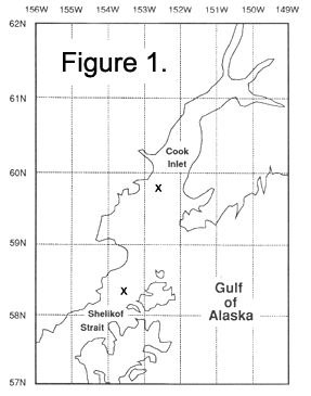
The Department of Interior!s Minerals Management Service is making available digital well log data from two wells in the Gulf of Alaska through the National Geophysical Data Center (now the National Centers for Environmental Information). The Cardinal and Falcon wells, drilled by Chevron U.S.A. Inc. in 1984 are located in Lease Nos. OCS-Y-0248, Shelikof Strait, and Lease No. OCS-Y-0243, Lower Cook Inlet-OCS Block 225 (see Figure 1). Exact locations are 58 degrees 20 minutes 29.045 seconds North, 153 degrees 32 minutes 30.189 seconds West (x=468,267.18 M. Y=6,466,623.17 M. UTM Zone 5) and 59 degrees 46 minutes 45.2 seconds N, 152 degrees 36 minutes 0.68 seconds W (X=522,450 M. Y=6,626,691 M. UTM Zone 5). The magnetic tapes are written in LIS format. Data include dual reduction resistivity, gamma ray and natural gamma ray, spontaneous potential, litho density quick look, compensated neutron log, borehole compensated sonic among other measurements.
Data Available:
- Lower Cook Inlet, 2 tapes (LIS, 1600 BPI) product 959A07001
- Shelikof Strait, 2 tapes (LIS, 1600 BPI) product 959A07002
|