Core data from the Ocean Drilling Program legs 101-129
Indian Ocean
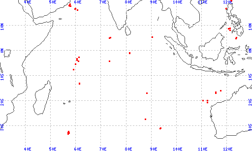
(Holes are sorted by latitude, longitude in the list below.)
| hole | leg | latitude | longitude |
|---|
| 733B | 118 | -33.08833 | 56.97750 |
| 733C | 118 | -33.08833 | 56.97750 |
| 733A | 118 | -33.08750 | 56.97750 |
| 733D | 118 | -33.08183 | 56.98950 |
| 735C | 118 | -32.72400 | 57.26583 |
| 735B | 118 | -32.72366 | 57.26616 |
| 735A | 118 | -32.72166 | 57.27166 |
| 732E | 118 | -32.54750 | 57.04500 |
| 732F | 118 | -32.54750 | 57.04500 |
| 732D | 118 | -32.54750 | 57.04500 |
| 732C | 118 | -32.54683 | 57.05483 |
| 732A | 118 | -32.54683 | 57.05483 |
| 732B | 118 | -32.54683 | 57.05483 |
| 734G | 118 | -32.11583 | 57.13500 |
| 734A | 118 | -32.11383 | 57.13016 |
| 734B | 118 | -32.11366 | 57.13000 |
| 734F | 118 | -32.11266 | 57.12900 |
| 734E | 118 | -32.11266 | 57.12900 |
| 734D | 118 | -32.10600 | 57.10400 |
| 734C | 118 | -32.10600 | 57.10400 |
| 755A | 121 | -31.02980 | 93.54670 |
| 754B | 121 | -30.94060 | 93.56650 |
| 754A | 121 | -30.94060 | 93.56650 |
| 752B | 121 | -30.89140 | 93.57750 |
| 752A | 121 | -30.89120 | 93.57800 |
| 753A | 121 | -30.83900 | 93.58990 |
| 753B | 121 | -30.83850 | 93.58990 |
| 756B | 121 | -27.35550 | 87.59680 |
| 756A | 121 | -27.35550 | 87.59680 |
| 756D | 121 | -27.35480 | 87.59740 |
| 756C | 121 | -27.35420 | 87.59820 |
| 763C | 122 | -20.58680 | 112.20850 |
| 763A | 122 | -20.58670 | 112.20830 |
| 763B | 122 | -20.58650 | 112.20870 |
| 766A | 123 | -19.93209 | 110.45405 |
| 762B | 122 | -19.88730 | 112.25400 |
| 762C | 122 | -19.88720 | 112.25400 |
| 762A | 122 | -19.88720 | 112.25430 |
| 757B | 121 | -17.02430 | 88.18160 |
| 757A | 121 | -17.02430 | 88.18160 |
| 757C | 121 | -17.02320 | 88.18020 |
| 759A | 122 | -16.95420 | 115.56020 |
| 759B | 122 | -16.95420 | 115.56050 |
| 760A | 122 | -16.92200 | 115.54130 |
| 760B | 122 | -16.92200 | 115.54110 |
| 761A | 122 | -16.73760 | 115.53500 |
| 761B | 122 | -16.73720 | 115.53500 |
| 761C | 122 | -16.73700 | 115.53500 |
| 764B | 122 | -16.56600 | 115.45720 |
| 764A | 122 | -16.56600 | 115.45720 |
| 765B | 123 | -15.97586 | 117.57516 |
| 765C | 123 | -15.97586 | 117.57516 |
| 765A | 123 | -15.97586 | 117.57516 |
| 765D | 123 | -15.97586 | 117.57516 |
| 705A | 115 | -13.16700 | 61.38367 |
| 706B | 115 | -13.11433 | 61.37100 |
| 706A | 115 | -13.11416 | 61.37100 |
| 706C | 115 | -13.11400 | 61.37100 |
| 707C | 115 | -7.54533 | 59.01683 |
| 707B | 115 | -7.54533 | 59.01683 |
| 707A | 115 | -7.54533 | 59.01683 |
| 708A | 115 | -5.45583 | 59.94383 |
| 710A | 115 | -4.31167 | 60.98000 |
| 710B | 115 | -4.31167 | 60.98000 |
| 712A | 115 | -4.21650 | 73.40633 |
| 713A | 115 | -4.19300 | 73.39417 |
| 709C | 115 | -3.91500 | 60.55167 |
| 709A | 115 | -3.91500 | 60.55167 |
| 709B | 115 | -3.91500 | 60.55167 |
| 711B | 115 | -2.74267 | 61.16300 |
| 711A | 115 | -2.74267 | 61.16300 |
| 718D | 116 | -1.02087 | 81.40108 |
| 718E | 116 | -1.02087 | 81.40108 |
| 718A | 116 | -1.02087 | 81.40108 |
| 718B | 116 | -1.02087 | 81.40108 |
| 718C | 116 | -1.02087 | 81.40108 |
| 719B | 116 | -0.96077 | 81.39945 |
| 719A | 116 | -0.96077 | 81.39945 |
| 717A | 116 | -0.92975 | 81.39013 |
| 717C | 116 | -0.92975 | 81.39013 |
| 717B | 116 | -0.92667 | 81.40000 |
| 716B | 115 | 4.93333 | 73.28333 |
| 716A | 115 | 4.93333 | 73.28333 |
| 714B | 115 | 5.06000 | 73.78667 |
| 714A | 115 | 5.06000 | 73.78667 |
| 715A | 115 | 5.08150 | 73.83133 |
| 758C | 121 | 5.38400 | 90.36110 |
| 758B | 121 | 5.38400 | 90.36120 |
| 758A | 121 | 5.38420 | 90.36120 |
| 720A | 117 | 16.13071 | 60.74398 |
| 731A | 117 | 16.47048 | 59.70248 |
| 731B | 117 | 16.47048 | 59.70248 |
| 731C | 117 | 16.47048 | 59.70248 |
| 722B | 117 | 16.62180 | 59.79528 |
| 722A | 117 | 16.62180 | 59.79528 |
| 721B | 117 | 16.67776 | 59.86450 |
| 721A | 117 | 16.67776 | 59.86450 |
| 721C | 117 | 16.67776 | 59.86450 |
| 729A | 117 | 17.64460 | 57.95466 |
| 728A | 117 | 17.68017 | 57.82573 |
| 728B | 117 | 17.68017 | 57.82573 |
| 730A | 117 | 17.73142 | 57.69198 |
| 727A | 117 | 17.76802 | 57.58856 |
| 727B | 117 | 17.76802 | 57.58856 |
| 726A | 117 | 17.81608 | 57.37154 |
| 723C | 117 | 18.05180 | 57.60898 |
| 723A | 117 | 18.05180 | 57.60898 |
| 723B | 117 | 18.05184 | 57.60814 |
| 724B | 117 | 18.46247 | 57.78653 |
| 724C | 117 | 18.46247 | 57.78653 |
| 724A | 117 | 18.46247 | 57.78653 |
| 725B | 117 | 18.48731 | 57.70061 |
| 725C | 117 | 18.48731 | 57.70061 |
| 725A | 117 | 18.48731 | 57.70061 |
introduction | data types | geographic areas | legs/sites/holes | sites/holes
Cite as: Ocean Drilling Program (1992): Archive of Historic Core Data from the Ocean Drilling Program (ODP) Legs 101-129 (Pre-JANUS). National Geophysical Data Center, NOAA. doi:10.7289/V50V89RB
*The current web version of the ODP CD-ROM
has been modified to provide access to related resources, and to update links and organizational information.
|
, formerly the NOAA National Geophysical Data Center (NGDC)")
