|
|
ETOPO1 Global Relief Model
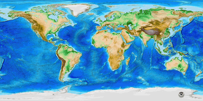
ETOPO1 is a 1 arc-minute global relief model of Earth's surface that integrates land topography and ocean bathymetry. Built from global and regional data sets, it is available in "Ice Surface" (top of Antarctic and Greenland ice sheets) and "Bedrock" (base of the ice sheets).
ETOPO1 Global Relief Model is used to calculate the Volumes of the World's Oceans and to derive a Hypsographic Curve of Earth's Surface.
Cite ETOPO1: doi:10.7289/V5C8276M
Grid Versions
Registrations
- Grid/node-registered: cells are centered on lines of latitude and longitude (21601 by 10801 cells).
- Cell/pixel-registered: cell edges are along lines of latitude and longitude (21600 by 10800 cells).
The grid-registered is the authoritative registration. The cell-registered is derived from the grid-registered, and the conversion produces slightly flattened relief.
About grid registration.
Datums
- Horizontal datum: WGS 84 geographic
- Vertical datum: sea level. More specific vertical datums, such as mean sea level, mean high water, and mean low water, differ by less than the vertical accuracy of ETOPO1 (~10 meters at best), and are therefore effectively equivalent.
Custom Grids
|
|


