
|
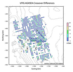
Antarctic airborne gravity dataFree-Air Gravity Anomalies Over the Thwaites Glacier Catchment, West AntarcticaThis airborne free-air gravity dataset over Thwaites Glacier in the Amundsen Sea Embayment of West Antarctica was collected and processed primarily by the Univeristy of Texas at Austin, Institute for Geophysics (UTIG) in the austral summer of 2004-2005. The survey was named AGASEA (Airborne Geophysics of the Amundsen Sea Embayment, Antarctica) and we used a Micro-G LaCoste Air/Sea II gravimeter. Five flights of data were collected during that same Antarctic field season by the British Antarctic Survey and are included in these gridded gravity anomalies and crossover differences. This dataset covers an irregularly-shaped area between Longitudes 135 deg W and 93 deg W and Latitudes 72 deg S and 82 deg S. The data lines were flown at an angle to the northing and easting lines of a polar stereographic projection with true scale at 71 deg S (called ps71). Flight line spacing was a 15 km regular grid with extra lines of data collected at angles to the grid as the opportunity arose (draped lines following glacier flow lines were flown but not included in this gravity dataset because gravity could not be recovered during draped flying). Files available:
|
Please cite the following reference when using these data:
Diehl, T. M., J. W. Holt, D. D. Blankenship, D. A. Young, T. A. Jordan, and P. Ferraccioli (2008),
First airborne gravity results over the Thwaites Glacier catchment, West Antarctica, Geochem. Geophys. Geosyst., 9, Q04011,
doi:10.1029/2007GC001878.
Collection and processing of this free-air gravity dataset was funded by the National Science Foundation grant OPP-0230197, the Jackson School of Geosciences and the Geology Foundation at the University of Texas at Austin, the G. Unger Vetleson Foundation, and the UK Natural Environment Research Council.
Contact the author for questions or electronic copies of the paper:
|
| All MGG Data | All Marine Geophysics | Bathymetry | Seismic Reflection | Trackline Geophysical Data Viewer |
