 Great Lakes Data Rescue
Project - Lake Ontario Bathymetry
Great Lakes Data Rescue
Project - Lake Ontario Bathymetry
The National Geophysical Data Center (NGDC) proposed the following names to the U.S. Board on Geographic Names and they were accepted by the board in 1999. The two references used are listed in full below.
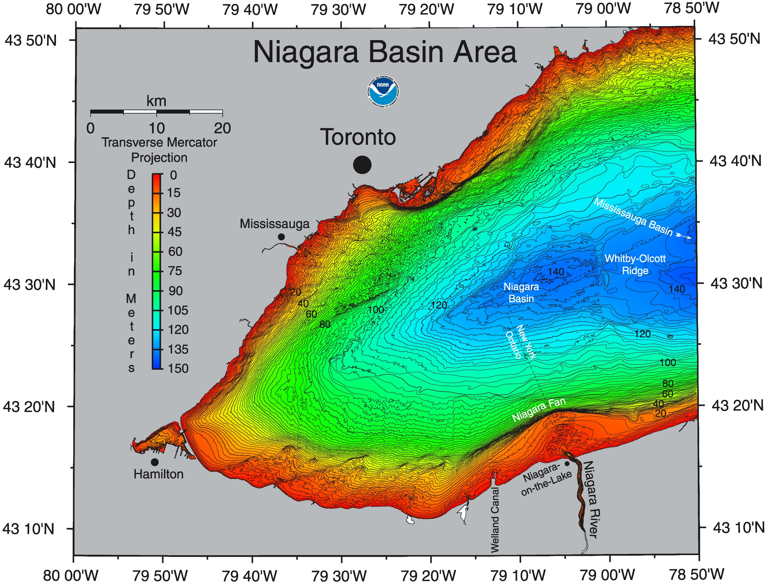
NIAGARA FAN(1.3 mb) - Occurs directly off the mouth of the Niagara River. Referred to previously as Niagara Bar (Sly and Prior, 1984), but according to definitions of deep-sea features we refer to it as a fan.
NIAGARA BASIN(2.7 mb) - Named (by Thomas et al, 1972) because of its location directly north of the mouth of the Niagara River.
WHITBY-OLCOTT RIDGE(2.7 mb) - This small ridge separating the Niagara Basin from the Mississauga Basin extends directly southward from the town of Whitby on the Ontario shore. Referred to previously as the Whitby-Olcott Sill (Thomas et al, 1972), this feature was traced south from Whitby, then southeastward to the vicinity of the town of Olcott NY on the southern shore. We elected not to continue referring to the broad southeastward extension of this feature, because better bathymetry shows no such extension. However we retained use of the name Whitby-Olcott.
MISSISSAUGA BASIN(5.3 mb) - Named (by Thomas et al, 1972) after the large suburban city of Mississauga. The city is located on the Ontario shore directly SW of downtown Toronto.
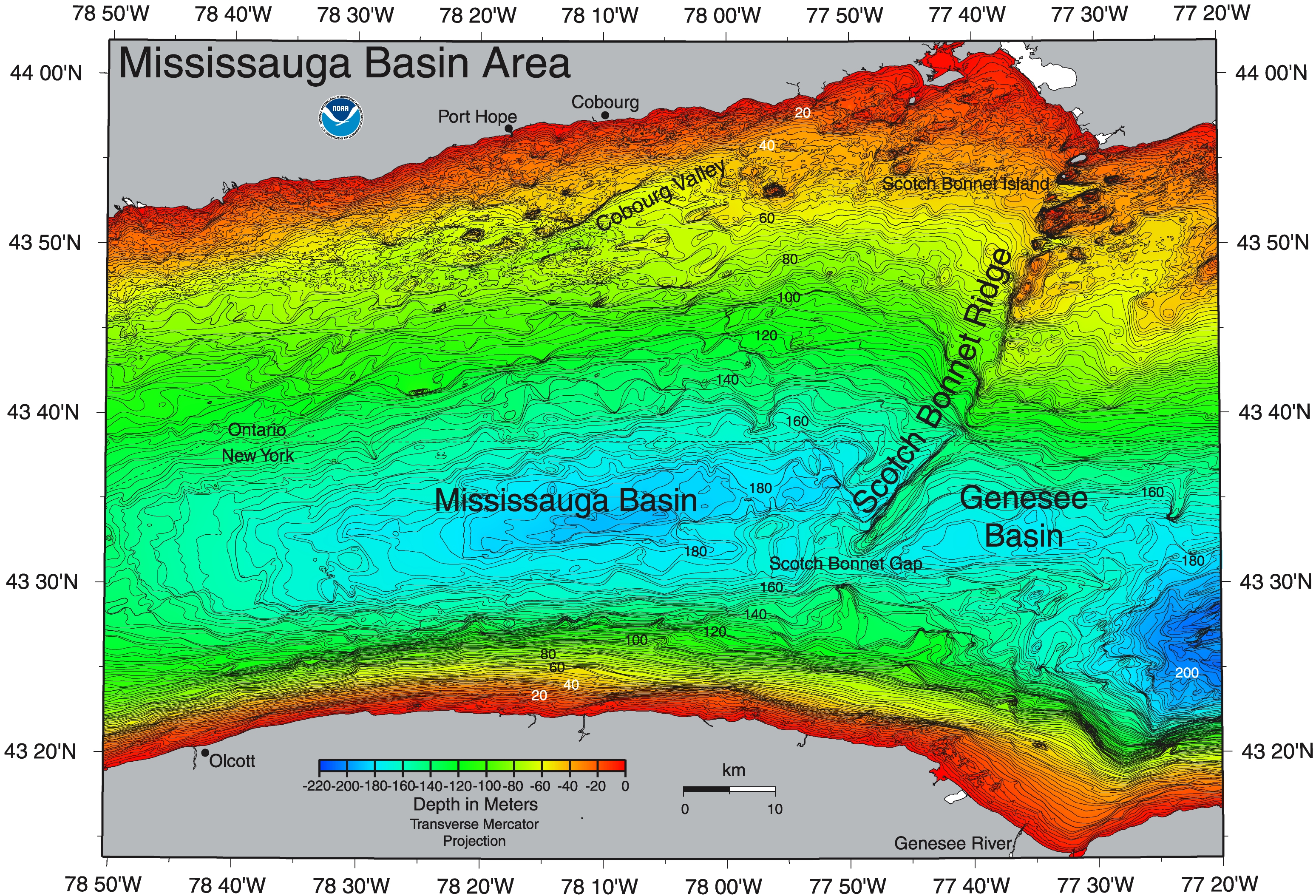
SCOTCH BONNET RIDGE(5.3 mb) - Named Scotch Bonnet Sill by Thomas et al, 1972. We changed the name to Scotch Bonnet Ridge, and also elected not to include the broad southeastward extension of this feature (seen below 43.5N) as was included originally by Thomas et al. Scotch Bonnet Island is a small island found on this ridge ~1 km southwest of the larger island, Nicholson Island.
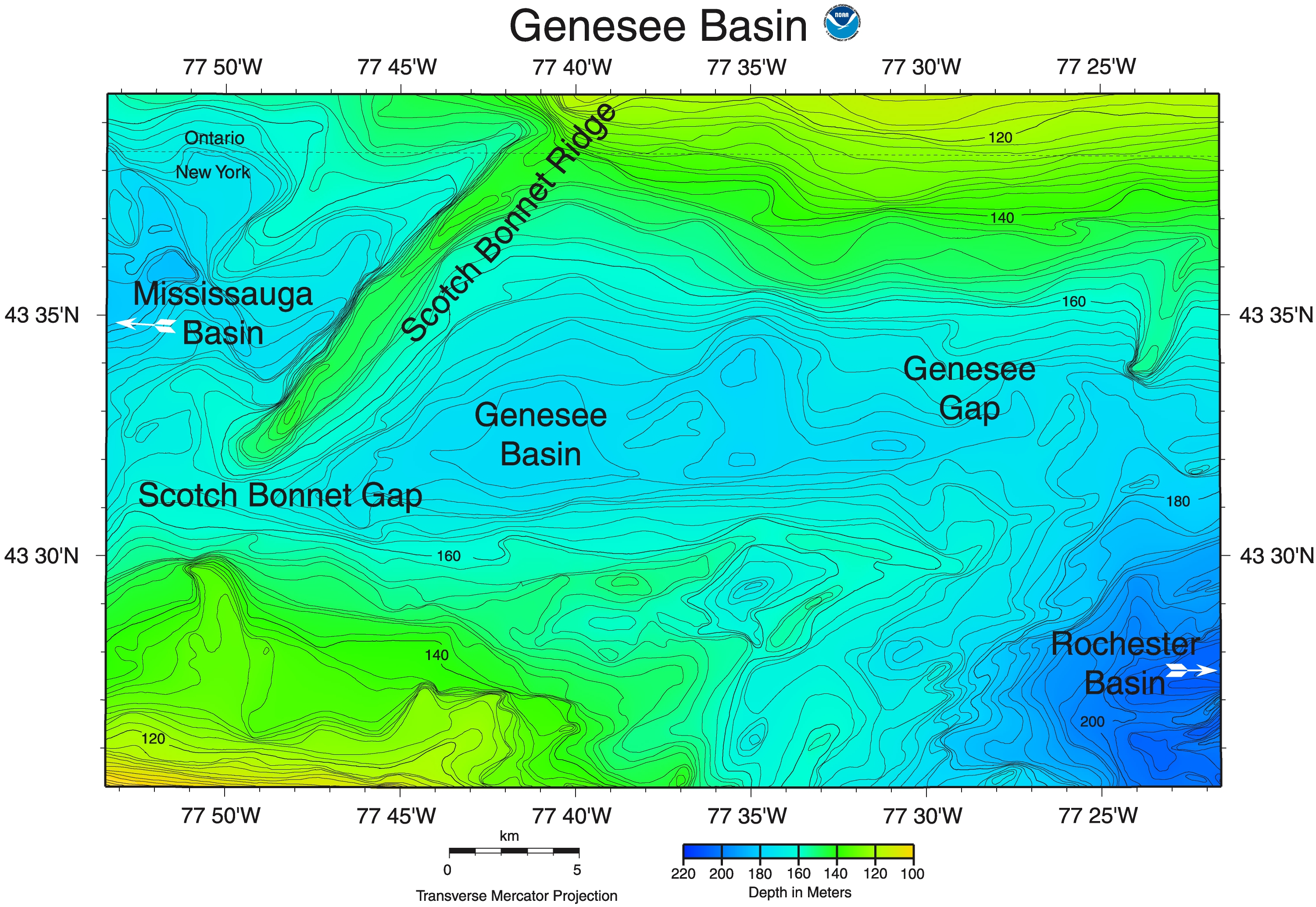
SCOTCH BONNET GAP(3.1 mb) - So named by the NGDC because it breaches the Scotch Bonnet Ridge at its deepest point.
GENESEE BASIN(3.1 mb) - This feature is so named by the NGDC because of its occurrence directly north of the mouth of the Genesee River in New York State. It was originally included as part of the Rochester Basin, but we identified it as a separate basin because it is separated from the Rochester Basin by a low sill; and because it is distinctly shallower than the Rochester Basin.
GENESEE GAP(3.2 mb) - This gap, so named by the NGDC because of its proximity to the Genesee Basin and the mouth of the Genesee River in New York, extends from the Genesee Basin to the Rochester Basin and breaches the Point Petre Ridge.
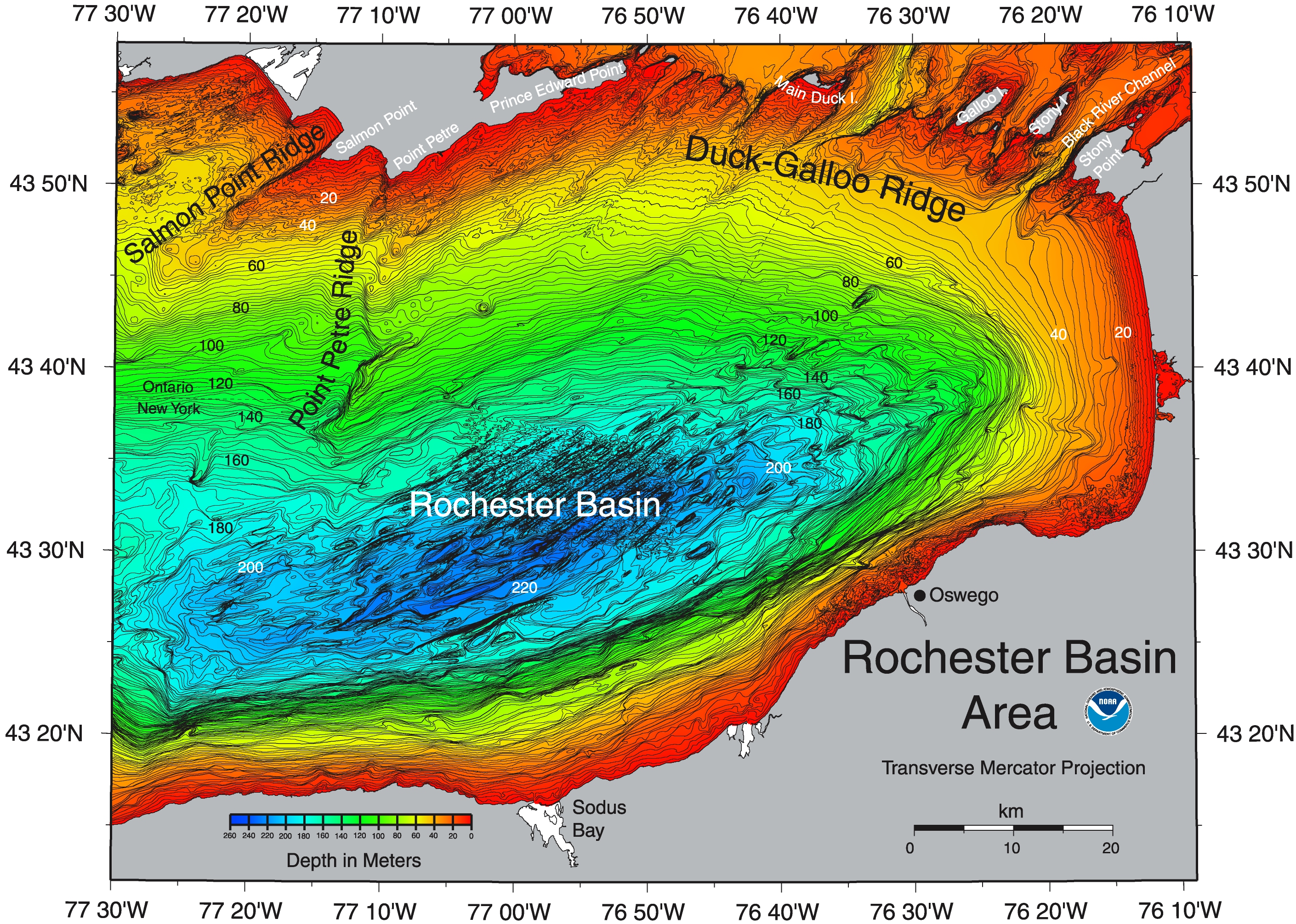
POINT PETRE RIDGE(4.7 mb) - So named by the NGDC because it extends directly southward and southwestward of Point Petre, southernmost point of Prince Edward County, Ontario. The ridge is segmented and in places divided into two parts, but the name is intended to apply to all segments, which roughly align.
ROCHESTER BASIN(4.7 mb) - So named (by Thomas et al, 1972) because of its proximity to the city of Rochester NY.
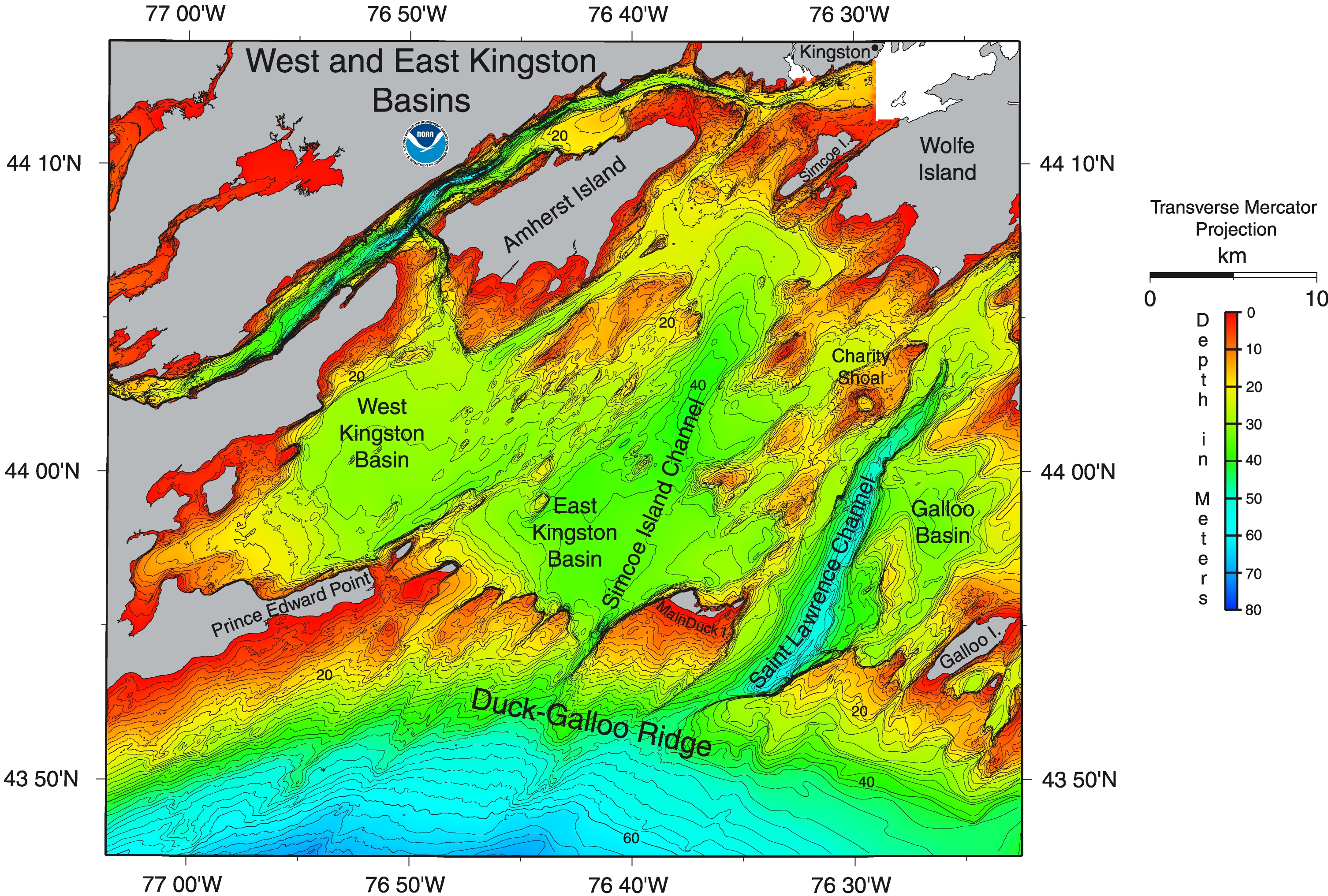
DUCK-GALLOO RIDGE(3.6 mb) - So named because of the two islands, Main Duck and Galloo, which occur along its extent between Prince Edward Point Ontario and Stony Point NY. Thomas et al, 1972, originally named this feature the Duck-Galloo Sill, but we refer to it as the Duck-Galloo Ridge, ridge being preferred because the feature is morphologically a ridge, segmented at several points by individual sills.
WEST KINGSTON BASIN and EAST KINGSTON BASIN(3.9 mb) - The name, Kingston Basin, was originally given by Thomas et al, 1972, to the entire complex of shallow basins, sills, ridges, channels, and islands lying north of the Duck-Galloo Ridge in Lake Ontario. The NGDC elected to use the name Kingston for these two morphologically distinct basins occurring within this area. The city of Kingston Ontario lies northeast of these morphologically distinct shallow basins.
SIMCOE ISLAND CHANNEL(3.9 mb) - This channel extends directly southwestward from Simcoe Island, Ontario and was named by the NGDC.
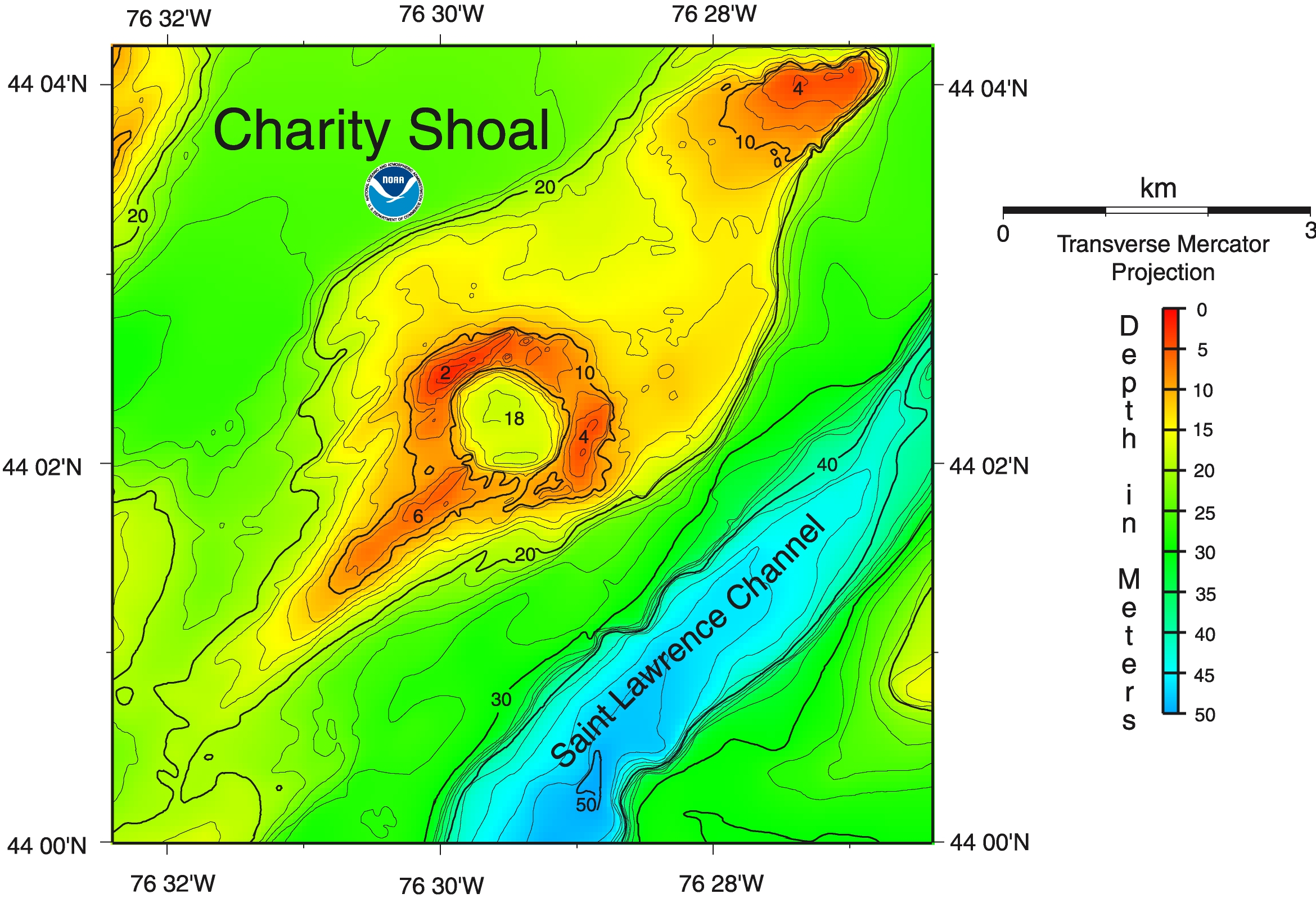
CHARITY SHOAL(1.6 mb) - This feature has been referred to by Sly and Prior, 1984 as the Charity Shoal and we presented it as such.
SAINT LAWRENCE CHANNEL(3.6 mb) - This feature was earlier referred to as the Saint Lawrence Trough by Sly and Prior, 1984. The feature breaches the Duck-Galloo Ridge and extends northeastward into the Saint Lawrence River as the main channel. We elected to refer to this feature as the Saint Lawrence Channel because the feature morphologically resembles a channel more than a trough, as per definitions of deep-sea features.
GALLOO BASIN AND STONY BASIN(3.2 mb) - These small basins were named by the NGDC after the two islands with the same names which lie nearby.
BLACK RIVER CHANNEL(3.2 mb) - This feature was so named by the NGDC because it leads southwestward from the mouth of the Black River, through the Duck-Galloo Ridge to the main basin of Lake Ontario.
References:
Thomas, R. L., Kemp, A. L. W., and Lewis, C. F. M., 1972, Distribution, composition, and characteristics of the surficial sediments of Lake Ontario, Journal of Sedimentary Petrology, v. 42, p. 66-84.
Sly, P. G., and Prior, J. W., 1984, Late glacial and postglacial geology in the Lake Ontario basin, Canadian Journal of Earth Sciences, v. 21, p. 802-821.