SELECTIVE COMPARISONS OF GEBCO (1979) AND IBCAO (2000) MAPS
(click on figures in report for enlarged views)
Martin Jakobsson, Stockholm University
martin.jakobsson@geo.su.se
Ron Macnab, Geological Survey of Canada
macnab@agc.bio.ns.ca
Members of the Editorial Board, IBCAO
arctic-bathy@ldeo.columbia.edu
|
Introduction
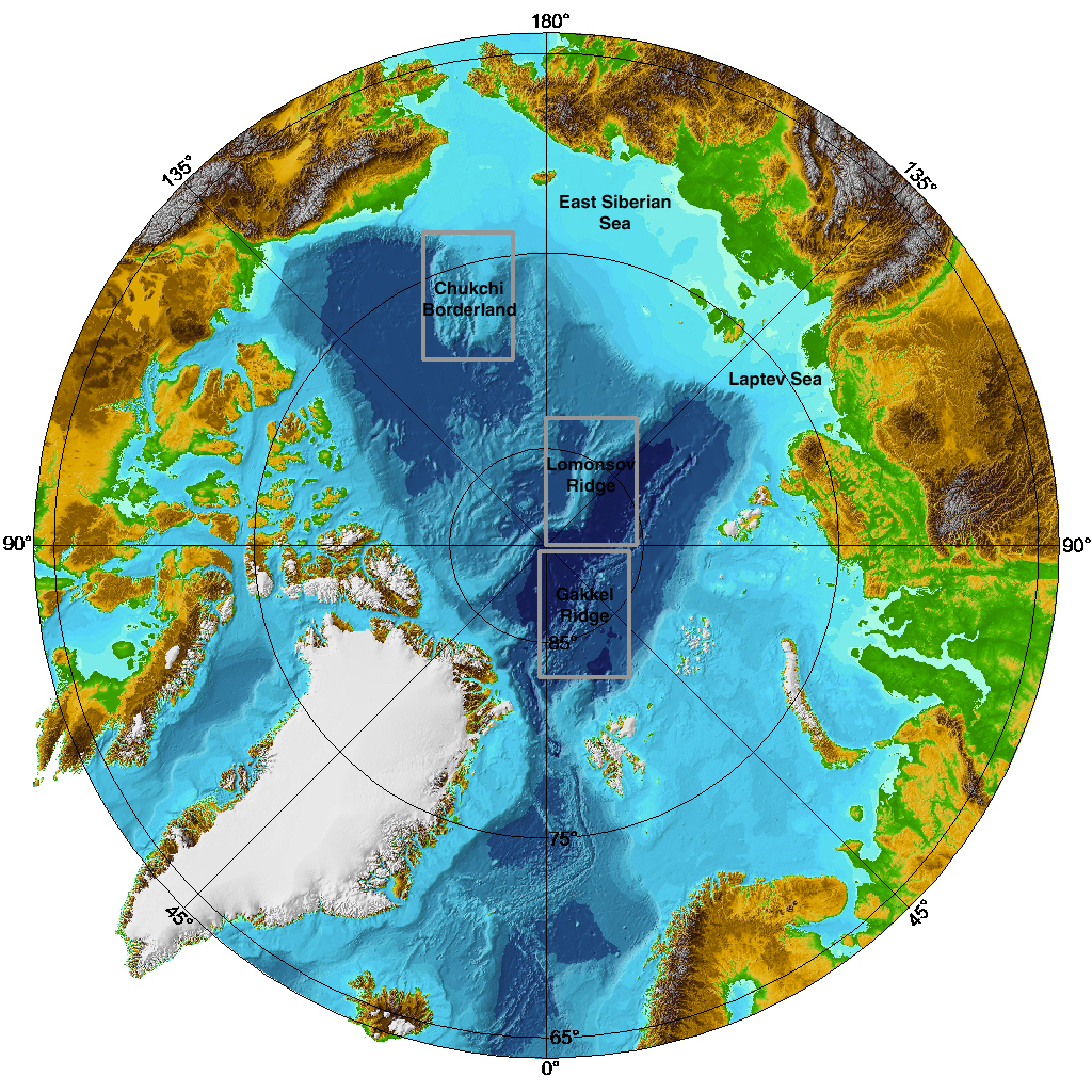
The International Bathymetric Chart of the Arctic Ocean (IBCAO) was developed from an accumulation of bathymetric measurements collected during past and modern expeditions. The undertaking has produced a 2.5 x 2.5 km grid and derivative maps (Jakobsson et al., 2000) that represent a considerable improvement over previous descriptions of the morphology of the Arctic seabed. The most substantial improvement is in the central Arctic Ocean, where a nearly empty database was significantly enriched by the addition of historic and modern observations collected by US and British submarines (DeLaca and Gossett, 1996; Showstack, 1997), by Swedish and German icebreakers, and by depths derived from a new contour map prepared by the Russian Navy (Head Department of Navigation and Hydrography et al., 1999). The database for the shallow shelves of the Laptev and East Siberian Seas has been enhanced as well, absorbing a large quantity of depth values that were extracted from a suite of small scale navigational charts issued by the Russian Navy. This note provides examples of the above improvements by contrasting the GEBCO and IBCAO representations of the seafloor in four regions of the Arctic Ocean: the Gakkel Ridge, the Lomonosov Ridge, the Chukchi Borderland, and the continental shelves of the Chukchi, Eastern Siberian and Laptev Seas. These regions are shown on the cover page. The GEBCO information that was used in this comparison was actually taken from a digital rendition of GEBCO Sheet 5.17, constructed from bathymetric contours that were distributed on CD-ROM as part of the GEBCO Digital Atlas (Jones et al., 1994). The contours were used to develop a Cartesian depth grid (5 x 5 km grid cells) on a polar stereographic map projection with the true scale at 75°N (Geological Survey of Canada, 1994). These map parameters are consistent with the original paper map, and they are also compatible with those of the new IBCAO map. Both the GEBCO and the IBCAO grids were created by means of the GMT program surface (Smith and Wessel, 1990). The comparisons that follow consist of side-by-side shaded relief portrayals of three study areas, constructed from the GEBCO and IBCAO grids using identical illumination parameters and color tables (Figure 1).
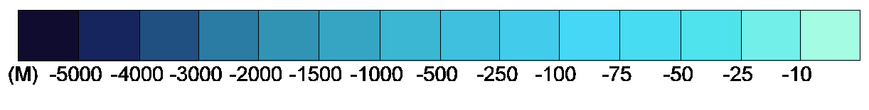
The Gakkel Ridge
The GEBCO map portrays the western end of the Gakkel Ridge with a smooth and highly generalized morphology (Figure 2). On the IBCAO map, the Ridge flanks feature a blocky configuration, while the Ridge's axial valley is continuous, more pronounced, and deeper, reaching depths below 5000 m and containing several interaxial highs.
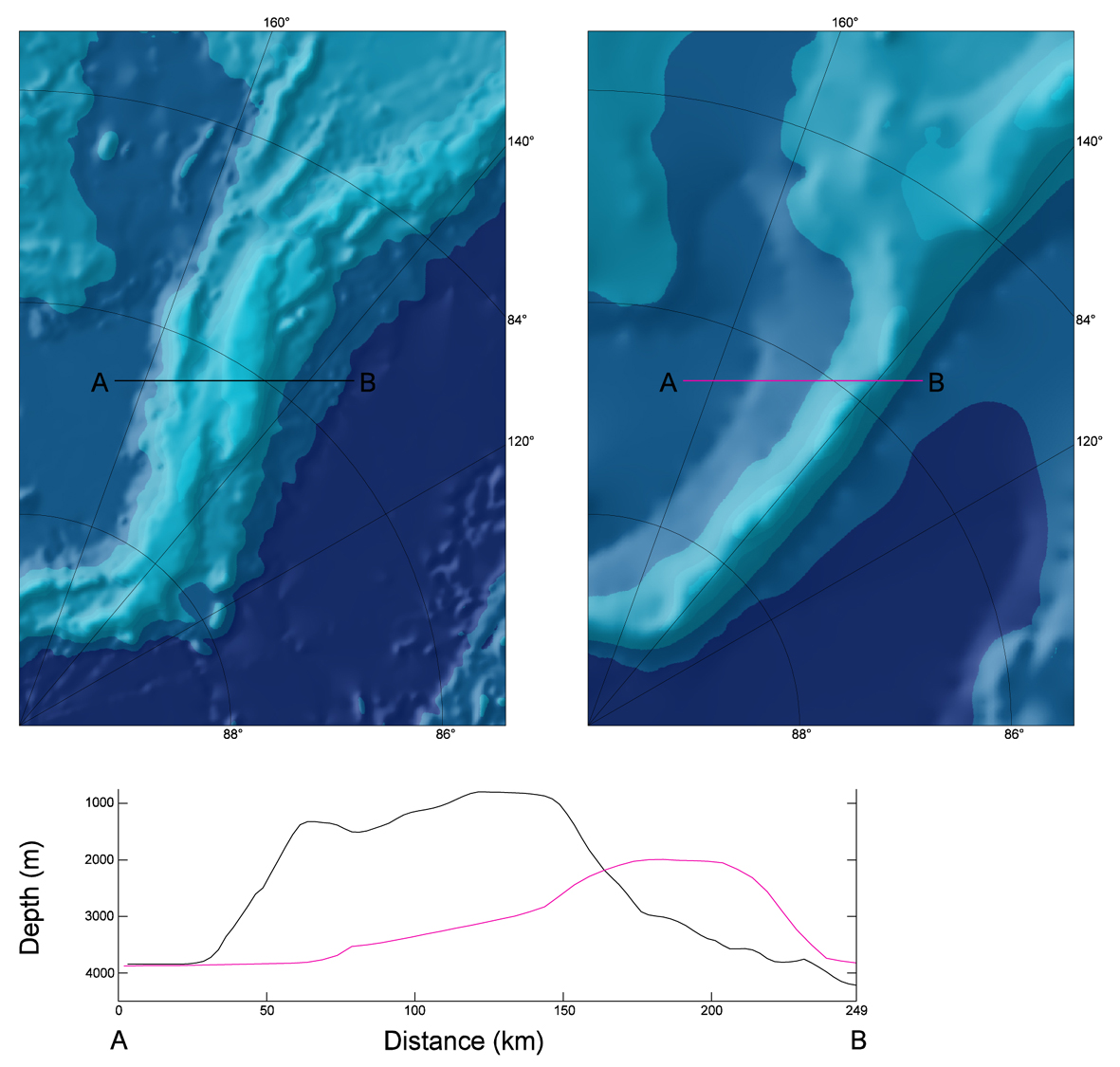
The Lomonosov Ridge
On the GEBCO map, the Lomonosov Ridge is a continuous feature that extends from the continental shelf off Ellesmere Island towards the North Pole, where it changes direction slightly and continues along the 140°E meridian to the continental shelf off the New Siberian Islands. The most striking discrepancies between the GEBCO and IBCAO portrayals occur between the North Pole and the Siberian continental shelf (Figure 3). The new model shows a far more complex morphology, with a ridge that is broken into several smaller segments, and a pronounced kink that projects into Amundsen Basin. Moreover, the crest is generally shallower, wider, and notably flattopped at several sections.
The Chukchi Borderland
GEBCO and IBCAO comparisons are limited here to the Northwind Ridge and the Chukchi Cap. Both are among the more extensively mapped features in the Arctic Ocean, see e.g. the compilation map published by the US Naval Research Laboratory (Perry et al., 1985).
On the IBCAO map, these features appear to be more highly segmented than on previous maps, and their surfaces display irregularities that suggest complex sea-floor processes (Figure 4).
The continental shelves of the Eastern Siberian and Laptev Seas
With a 50 m minimum depth contour, the GEBCO map reveals very little bathymetric information over these huge shelf areas. On the other hand, a shaded relief implementation of the IBCAO map is effective at portraying depth variations of only tens of metres, accentuating the shallow paleo-river valleys that incise these areas, along with low-relief erosional and depositional features (Figure 5).
Bibliography
DeLaca, T., and J. Gossett. Nuclear Submarines and Oceanography in the Arctic; Witness the Arctic: Chronicles of the Arctic System Science Research Program, Arctic Research Consortium of the United States, Spring 1996, Vol. 3, No. 1., 1996. Geological Survey of Canada. Bathymetric and topographic shaded relief north of 64N; polar stereographic projection, variable scale, distributed in hardcopy or digital form. GSC Open File 2900, Geological Survey of Canada, Dartmouth NS, 1994. Head Department of Navigation and Oceanography, All-Russia Research Institute for Geology and Mineral Resources of the World Ocean, and Russian Academy of Sciences. Bottom relief of the Arctic Ocean; map 1:5 Million. Head Department of Navigation and Oceanography, St. Petersburg, 1999. Jakobsson, M., N.Z. Cherkis, J. Woodward, R. Macnab, and B. Coakley. New grid of Arctic bathymetry aids scientists and mapmakers; Eos, Transactions, American Geophysical Union, in press. Jones, M.T., A.R. Tabor, and P. Weatherall. GEBCO Digital Atlas: CDROM and supporting Volume. British Oceanographic Data Centre, Birkenhead, UK., 1994. Johnson, G. L., and Heezen, B. C. The Arctic Mid-Oceanic Ridge; Nature, vol. 215, pp. 724-725, 1967. Kristoffersen, Y. Eurasia Basin; In: A. Grantz, L. Johnson, and F.J. Sweeney (Eds.), The Arctic Ocean Region; DNAG, vol. L: pp. 365-378, 1990. Perry, R.K., H.S. Fleming, J.R. Weber, Y. Kristofferson, J.K. Hall, A. Grantz, G.L. Johnson. Bathymetry of the Arctic Ocean; map 1:4,704,075. Naval Research Laboratory, Washington, 1985. Showstack, R., Navy to Release Storehouse of Arctic Ocean Data. EOS, Trans. Amer. Geophys. Un. vol. 78, no. 35, pp. 370-371, 1997. Smith, W. H. F., and P. Wessel, Gridding with continuous curvature splines in tension, Geophysics, vol. 55, pp. 293-305, 1990. Sweeney, J. F., R. R. Weber, , and S. M. Blasco. Continental ridges in the Arctic Ocean: LOREX constraints; Tectonophysics, v. 89, p. 217-238, 1982. United States Arctic Research Commission. US Arctic Research Commission and US Navy Announce Release of Arctic Ocean Bathymetry Data; Press Release, August 21, 1997, US Arctic Research Commission, Arlington VA, USA. Vogt, P. R. Geophysical and geochemical signatures and plate tectonics; In: The Nordic Seas, Hurdle, B. G. (ed.), Springer-Verlag, pp. 413-662, 1986. |