5.A.x. Map for Part of Peru
|
Primary Developer:
|

|
Ministerio de Guerra, Peru
|
|
Title:
|
|
Mapa Fisico Politico del Peru
|
|
Publication Date:
|
|
1984
|
|
Bibliographic Citation:
|
|
Ministerio de Guerra, 1984. Mapa Fisico Politico del Peru. Ministerio de Guerra, Lima, Peru.
|
|
Post-processing:
|
|
Geographical Survey Institute (GSI, Japan) and U.S. Geological Survey (USGS) for GTOPO30.
|
Bibliographic Citation
for Post-processed DEM:
|
*
|
Ministerio de Guerra, GSI and USGS, 1997. 30"-gridded DEM from Peruvian Maps. USGS, EROS Data Center, Sioux Falls, South Dakota.
|
|
Source/Lineage Category:
|
|
17
|
* Primary reference citation for this source
Small areas of a 1:1,000,000-scale map, entitled Ministerio de Guerra Mapa Fisico Politico del Peru, produced in 1984, were adapted for digitizing to fill gaps in source data for South America. The map had a contour interval of 1000
meters. Digitizing was done by the Geographical Survey Institute of Japan.
USGS used ANUDEM-based contour-to-grid techniques to create DEMs from these digitized map areas. That procedure is described in Section 5.A.vii.
|
Cell-center registration; contour-to-grid value computed.
Graphic describing georeferencing and sampling for Peru map conversion.
|
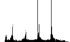
Plate 29.
Click on the image
to view larger size.
|
|
Plate 29 has broad peaks and sharp spikes at increments of 1000m, with a subsidiary peak/spike at 500m, and few values below 400m. The latter is consistent with the coverage of this data set, which includes no
coastal areas.
|

Return to Report Introduction
|
