 Great
Lakes Data Rescue Project - Lake Erie and Lake Saint Clair
Bathymetry
Great
Lakes Data Rescue Project - Lake Erie and Lake Saint Clair
Bathymetry
Introduction | Grids | Vector data files | Images
Great
Lakes Data Rescue Project - Lake Erie and Lake Saint Clair
BathymetryIntroduction | Grids | Vector data files | Images
|
Geomorphology Text Outline
|
|
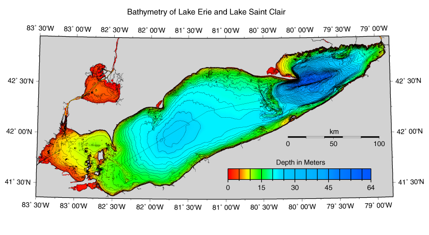
The New Bathymetry of Lake Erie and Lake Saint Clair was compiled at a one meter contour interval at scales ranging from 1:100,000 to 1:2,500 and registered to the NOAA nominal scale 1:80,000 digital vector shoreline. The compilation was achieved using all good quality historic hydrographic sounding data collected since 1903 from the NOAA National Ocean Service and its predecessor agency for Great Lakes surveying, the Army Corps of Engineers, and the Canadian Hydrographic Service. Digital sounding data, combined with sounding data archived only on paper were used in the compilation with no vertical adjustment. Since 1933, U.S. and Canadian survey data for Lake Erie and Lake Saint Clair has been calibrated to a mean low water standard physical datum in Cleveland, Ohio. Density of tracklines ranges from about 125 m to 500 m for nearshore areas to 500 m to 2500 m for the open lake regions. In preparation for bathymetric contouring, digital soundings were converted to metric units and plotted in color; separate colors were assigned to various depth ranges. The data were hand contoured by geomorphologists to capture and portray the maximum information available with a degree of detail not attainable by machine contouring. The compilation sheets were scanned and vectorized and then edited using ArcGIS®. Images were constructed with the resulting digital vector bathymetric contour data using Adobe Illustrator® and the publicly - available software "Generic Mapping Tools" (GMT).
The new bathymetry of Lake Erie and Lake Saint Clair offers detail that exceeds that of any previous bathymetry for the two lakes. The shape and location of previously known features are defined more clearly and other features are revealed for the first time. In the following text the geomorphology of a number of these lakefloor features is discussed, from the perspective of improved definition of the features provided by the new bathymetry, as well as the known geological history of the Lake Erie region. To begin with, a brief summary of the highlights of lake floor evolution is included. At the end, a list of relevant articles is appended for further reading.
Highlights of Lake Floor Evolution:
1) A succession of Paleozoic (250-500 million years before present) strata were deposited over the region, including the easily erodible Devonian (350-400 million years before present) shallow water marine shales and carbonates into which the Lake Basin was eroded.
2) An elaborate system of drainage channels was incised into the Paleozoic bedrock during post-Paleozoic, pre-glacial time when the region was elevated above sea level.
3) Repeated episodes of glacial erosion excavated the lake basin during Pleistocene time (1-2 million years before present).
4) Final retreat of glacial ice from the area about 13,000 years before present left in place a topographic surface formed by erosion of bedrock and by deposition of sediments underneath and near the margins of the ice sheet.
5) Lake floor topography was modified following deglaciation by deposition and current sculpting of sediments on the lake floor. Anthropogenic effects of dredging and mining also contributed to modification of topography.

The floor of Lake Saint Clair is very shallow, with the deepest point lying just in excess of 6 meters. Microtopography formed by dumping of dredge spoils is present on either side of the dredged sealane channel extending across the lake. Other small-scale topography, including a ridge extending northward from the south shore, may be anthropogenic features. The Delta of the Saint Clair River is the dominant feature of the Lake. This platform of deltaic deposits has been built out into the Lake, the outer edge of which is bounded by foreset slopes extending downward from platform depths of less than one meter to more than 3 meters depth.

The islands and reefs bordering and lying within the western basin have bedrock cores which are erosional remnants of the more resistant rock strata. Highest relief within western Lake Erie, about 15-20 meters, occurs on, and in waters adjacent to, the Bass Islands. The islands and reefs occur mainly in two north-south bands, the western band (Bass Islands, Catawba Island, Middle and East Sister Islands) formed on erosional remnants of resistant upper Silurian dolomites of the Put-in-Bay and Raisin River Formations, and the eastern band (Marblehead, Kelleys Island, Pelee Island) formed on erosional remnants of resistant lower Devonian limestones of the Columbus Formation. The natural channels which occur in the straits between the Bass Islands and adjacent to these islands to the west are overdeepened where strong currents have eroded/corroded through the limestone and dolomite bedrock. The deepest channel depth is the 19-meter Starve Island Deep located between the southern-most Bass Island and Marblehead Peninsula.

PELEE-LORAIN RIDGE
The Pelee-Lorain Ridge extends southeastward from Pelee Island almost to the
Ohio shore. Previously it was assumed that this low ridge was continuous between
Point Pelee and its southern terminus near the Ohio shore. This new bathymetry
shows clearly, however, that the Pelee-Lorain Ridge is not continuous with Point
Pelee, but is instead continuous with Pelee Island, 20 kilometers to the southwest.
This ridge has been interpreted as an end moraine probably associated with a
re-advance of the retreating Wisconsin Ice Sheet, and probably correlating with
the proglacial Lake Maumee II.
POINT PELEE RIDGE
Point Pelee Ridge includes Point Pelee and extends offshore south-
southeast for a distance of about 10 kilometers, where it ends
abruptly. This ridge has 6-8 m of total relief and extends up to
depths of less than 5 meters. Previous interpretations have
presented Point Pelee together with the Point Pelee Ridge as
moraine associated with the Pelee-Lorain Ridge on which 3500
years before present-to-recent sand deposits have been
concentrated. Since 3500 years before present, the subaerial extent
of Point Pelee has diminished as a consequence of continued rising
water levels.
Sand transport and deposition were apparently more prolific in the past 3500 years than at present. Thickness of the sand is highly variable up to a maximum thickness of 10 meters. Sources for the sand include in-place sand concentrated by winnowing of glacial till deposits, and sand from eroding till deposits which lie principally to the north along the Ontario shore in both directions, with sand having been transported by longshore sediment drift converging on Point Pelee. Apparently, sand sources and the transport mechanisms have adjusted to the changing water circulation and shoreline configurations concomitant with rising water levels. It is noted particularly that depth contours converge from north to south along the western shore of Point Pelee, suggesting that Point Pelee has recently evolved into a narrower spit projecting farther south.
POINT PELEE FAN
Extending to the east of the Point Pelee Ridge is the Point Pelee Fan,
a fan-shaped delta-like body of sediments which crests at 11-12
meters below present lake level. This fan is recognizable down
slope to a depth of 18 meters and extends as far south as the Pelee-
Lorain Ridge. Because of its crestal depth of 11-12 meters, we
believe that this fan may have been principally formed at the time
when the lake level was at about 10-15 meters lower than at
present, prior to deposition of the shallower 3500 years before
present- to- present sands on the Point Pelee Ridge. If this fan is in
fact a relict shoreline feature, it may have been formed by the
Detroit River when the Port Huron outlet was first opened up and the
newly formed Detroit River was eroding its channel and bringing a
heavy load of sediment into Lake Erie. An alternate interpretation
for formation of the Point Pelee Fan is that strong west-to-east
currents have swept around the end of the Point Pelee Ridge and
carried sediments eastward.
SANDUSKY BASIN
West of the Pelee-Lorain Ridge, the shallow, 12-14 meter deep Sandusky Basin,
slopes gently downslope from west to east, and has local relief of 1-2 meters.
Topographically it resembles a fan and it may have been the site of a shallow
lake and/or marsh, and/or delta during early and middle Lake Erie time. In terms
of basin configuration and continuity of the bounding walls, the Sandusky Basin
appears as an integral part of the Central Erie Basin, except
for the interposition of the Pelee-Lorain Ridge. Formation of the Pelee-Lorain
Ridge may therefore have been the event which separated the Sandusky Basin from
the Central Erie Basin.

LONG POINT SPIT
This is one of the most prominent topographic features in Lake Erie, extending
about 35 kilometers east-southeastward from the Ontario shore out into the Eastern
Erie Basin. The spit is a late Holocene-to-recent depositional feature constructed
of sand eroded from the Ontario shore cliffs to the west and brought eastward
and deposited by long shore drift. Steep slopes and 55 meters of relief, the
highest lake floor relief in Lake Erie, separate the Spit from the floor of
the Eastern Erie Basin, the direct physical manifestation of its recent depositional
origin.
PENNSYLVANIA CHANNEL
A ridge extending westward along the north wall of the Pennsylvania Channel
suggests a "natural levee" in which sediments eroded from the southern end of
the Long Point-Erie Ridge are carried westward and deposited as overbank deposits.
This channel is the location of strong return flow from the Eastern
Erie Basin to the Central Erie Basin, which is set up
during and following periods of strong frontal winds blowing from west to east
longitudinally down the length of the lake surface. Such winds transport surface
water eastward, raising lake levels in eastern Lake Erie and requiring a compensating
westward flow at depth once equilibrium is reached, or following relaxation
of the strong winds.
CLEAR CREEK RIDGE
A narrow ridge of 4-5 meters relief and a crestal depth ranging from 14-17 meters,
the Clear Creek Ridge extends in a SSE direction from the Ontario shore to the
Pennsylvania Channel near Erie, Pennsylvania. This ridge lies 10-30 km west
of the Long Point-Erie Ridge, with the distance between the two ridges closing
toward the southeast. Both ridges are convex to the west, with the Clear Creek
Ridge following a broader arc and having greater linearity. Clear Creek Ridge
was not known to exist until the advent of the bathymetry described here. Origin
of the Ridge is not precisely determined, but our hypothesis is that it formed
in early to middle Lake Erie time, when water level had risen sufficiently (probably
about 18 meters below present lake level) to create a large shallow lake in
the Central Erie Basin. Once wave energy was focused on
the western shore of the Long Point-Erie Ridge, an offshore bar or barrier island
formed.
LONG POINT-ERIE RIDGE
The Long Point- Erie Ridge is a broad (14-22 kilometers) arcuate
ridge of 5-10 meters overall relief, capped by complex topography,
extending upward to minimum depths of 10-15 meters, and
extending across the lake floor from near the inshore end of the Long
Point Spit, almost to the Presque Isle Spit at Erie, Pennsylvania.
This feature has been interpreted as an end moraine formed during
the last major re-advance of glacial ice into the Eastern Erie Basin.
Overall shape of the Eastern Erie Basin, and the arcuate shape and
topography of the Long Point-Erie Ridge, as seen in this new
bathymetry, strengthens the interpretation that this feature is an
end moraine.
PRESQUE ISLE SPIT
In morphology, the Presque Isle Spit has the form of a recurved spit
or hook. It coincides with a zone of convergence of net longshore
drift, the position of which is a consequence of predominant
patterns of large-scale wind-driven lake water circulation set up by
the overall shape of the Lake basin and predominant wind fields. The
inferred main source of sediments moving via longshore drift is
from the west. Sand deposits, which are potential sediment sources
occur in the near shore zone off Conneaut, Ohio and between
Cleveland and Fairport Ohio. Adjacent to the Presque Isle Spit to the
west lies a shallow bank (7-10 meters depth) which is roughly 5 x
10 kilometers in areal extent. Atop this bank is an arc-shaped bar
which resembles in size, shape, and orientation the main, recurved
portion of the Presque Isle Spit. Its position suggests that there
may have occurred an eastward shift in the locus of the zone of net
longshore convergence which is now centered about Presque Isle
Spit.

This north-facing escarpment is surrounded by irregular topography which has a relief of 1-5 meters and a dominant NE-SW lineation running at a diagonal to the escarpment. Possibly, the escarpment lies along the boundary separating gently southward dipping, more resistant upper Devonian deltaic sands and silts, or upper Devonian limestone beds, which are more resistant than the marine shales to the north. Alternately, the escarpment could have been formed along a preexisting fault, which had juxtaposed more resistant and less resistant strata. The escarpment is parallel to the inferred direction of flow of glacial ice advancing down the axis of the lake floor. Lack of large-scale irregularities along the edge of the escarpment reflects the likelihood that in the subglacial regime of erosion, any northward projections of the resistant eroding strata were sheared off by the eroding power of the ice.
![[ Northern Shore of
Eastern Erie Basin-West]](../images/a6a_tiny.jpg) |
![[Northern Shore of Eastern Erie Basin-East]](../images/a6b_tiny.jpg) |
| Northern Shore of Eastern Erie Basin-West | Northern Shore of Eastern Erie Basin-East |
NORTHERN SHORE OF EASTERN ERIE BASIN
An irregular shoreline underlain by relatively resistant bedrock,
capped by only a thin mantle of glacial drift, characterizes the
northern shore of the Eastern Erie Basin. Bedrock outcrops occur at
several locations along the shore. The irregularities of the
shoreline are continuous with NE-SW trending ridges and valleys
which extend offshore. These ridges are formed in relatively
resistant basal limestones of the Devonian (Bois Blanc and Dundee
Limestones in Ontario; continuing eastward as Bois Blanc and
Onondaga Limestones in New York State).
MAIN BASINS OF LAKE ERIE
The Western, Central, and Eastern Erie Basins, are deeper from west to east.
The Western Erie Basin extends to 10-11 meters depth, the Central Erie Basin
extends to 24-25 meters depth, and the Eastern Erie Basin extends to depths
exceeding 40 meters and reaches a maximum depth of 63 meters. The nearshore
zone all around the lake is characterized by irregular topography which deepens
abruptly within the first 1-3 kilometers of the shore, then flattens farther
offshore. This steeper topography near the shore extends to depths ranging
from 3 to 15 meters, such depths having the appearance of being proportional
to the amount of wave energy concentrated on different areas of the shoreline.
In most areas the high-energy zone is one of mostly active erosion with only
sand-sized sediments remaining in the zone and being moved via longshore drift.
Away from the shore zone the three basins are broadly bowl-shaped, with depths extending smoothly from near shore down to the greater depths. The bowl shape suggests postglacial deposition and sediment-smoothing in response to a gyre of water circulation in each basin, or progressive shoreline modifications in the zone of Holocene rising lake levels. This sediment-smoothing has diminished or eliminated surface relief left in place by the last glaciation. Only in the Eastern Erie Basin, at depths exceeding 35 meters, does topography have a remnant glacial character.
![[Western Erie
Basin]](../images/a7_tiny.jpg) |
![[Central Erie
Basin]](../images/a8_tiny.jpg) |
![[Eastern Erie
Basin]](../images/a9_tiny.jpg) |
| Western Erie Basin | Central Erie Basin | Eastern Erie Basin |
NORTH SHORE OF CENTRAL ERIE BASIN
Along the northern perimeter of the Central Erie Basin, lakeward from the nearshore
zone, there occurs a region of very fine-scale topography which includes local
areas with very small hills and topographic irregularities having one to several
meters relief. Some of the hills are elongated, some have a complex shape, and
some are aligned to form small ridges. Many of the small ridges are aligned
normal to or diagonal to the shore, but there are some ridges which parallel
the shore. This region varies in width, being 8-10 km wide along the shore east
of Point Aux Pins but extending quite far offshore along the western approaches
to the Long Point-Erie Ridge. Since this region is a high-energy subaqueous
area where no postglacial mud has accumulated, the fine-scale features are probably
either relict glacial topography, features formed by current erosion and sculpting,
or both. The Erieau Ridge is capped by glacial drift and is interpreted as a
segment of a morainic ridge.
CONNEAUT BANK AND FAIRPORT RIDGE
In overall shape, Conneaut Bank resembles a fan or delta, which
extends about 12 kilometers out into the Lake, and is about 15
kilometers in length in the longshore direction. Its top depths are
12 to 14 meters. It is asymmetrical, being shallower along its
eastern edge along an axis trending NW-SE. A series of small 1-2
meters relief ridges (current-formed features?) extend E-W across
the top of the bank. Surficial deposits of sand and/or gravel have
been mapped on the top of the bank. There appear to be several
possibilities for the origin of Conneaut Bank. It could be an early
Holocene delta formed when lake level was 12-14 meters below
present lake level. It could be a relict remnant of glacial moraine on
which sand and gravel deposits have been concentrated by current
winnowing. Or it could be a depositional feature whose growth is
analogous to the ridge north of Pennsylvania Channel, having as a
sediment source material which was transported westward in
Pennsylvania Channel and deposited on the south channel wall as
overbank deposits. To the west, Fairport Ridge is also capped by
sand deposits, and this feature may also have had an early Holocene
deltaic origin, or be a relic remnant of glacial moraine.
NEARSHORE TOPOGRAPHY SOUTH SHORE OF EASTERN BASIN
The southern shore bordering the Eastern Erie Basin is straighter than the northern
shore and is relatively free of coves and inlets. Middle and upper Devonian
marine shales and terrigenous siltstones crop out along the shore. These strata
intersect the shore at a low angle and extend westward beneath the Lake. Progressively
younger strata intersect with and crop out along the shore proceeding from east
to west. Offsets in the otherwise straight southern perimeter of the Eastern
Erie Basin appear to be the result of the erosive power of glacial ice acting
on successive groups of Devonian strata which have varying resistance to erosion.
BARNETT, P. J., 1998, Quaternary Geology, Long Point- Port Burwell Area, Ontario Geological Survey Report no. 298, 143p., maps.
BOLSENGA, S. J., and HERDENDORF, C. E., 1993, Lake Erie and Lake St. Clair Handbook. Wayne State University Press, Detroit MI, 467 p.
BOYCE, F. M., CHIOCCHIO, B. E., PENICKA, F., and ROSA, F., 1980, Hypolimnion flow between the Central and Eastern Basins of Lake Erie during 1977, Journal of Great Lakes Research, v. 6, p. 290-306.
CARTER, C. H., NEAL, W. J., HARAS, W. S., and PILKEY, O. H., 1987, Living with the Lake Erie Shore. Duke University Press, Durham NC, 263 p.
COAKLEY, J. P., 1972, Near shore sediment studies in Western Lake Erie, Proceedings of the 15th Conference on Great Lakes Research, International Association of Great Lakes Research, p. 330-343.
COAKLEY, J. P., 1978, Postglacial Evolution and Modern Processes at Point Pelee, Lake Erie, Canadian Geological Survey Paper no. 80-10, p. 429-436.
COAKLEY, J.P., 1992, Holocene transgression and coastal-landform evolution in northeastern Lake Erie, Canada, in Quaternary Coasts of the United States: Marine and Lacustrine Systems, SEPM (Society for Sedimentary Geology) Special Publication no 48, p 415-426.
FREEMAN, E. B. (editor), 1978, Geological Highway Map, Southern Ontario, Ontario Geological Survey Map no. 2418.
HARTLEY, R. P., 1960, Sand Dredging Areas in Lake Erie, Ohio Department of Natural Resources Division of Shore Erosion Technical Report no. 5., 52p.
HARTLEY, R. P., 1961, Bottom Deposits in Ohio Waters of Central Lake Erie, Ohio Department of Natural Resources Division of Shore Erosion Technical Report no. 6, 14p.
HERDENDORF, C. E., 1989, Paleogeography and Geomorphology of Lake Erie, in Lake Erie Estuarine Systems: Issues, Resources, Status, and Management, NOAA Estuary-of- the-Month Seminar Series no. 14, p. 35-70.
HERDENDORF, C. E., and BAILEY, M. L., 1989, Evidence for an Early Delta of the Detroit River in Western Lake Erie, Ohio Journal of Science, v. 89, p. 16-22.
HERDENDORF, C. E., and BRAIDECH, L. L., 1972, Physical Characteristics of the Reef Area of Western Lake Erie, Ohio Department of Natural Resources Division of Geological Survey Report of Investigations no. 82, 90p., maps.
HOBSON, G. D., HERDENDORF, C. E., and LEWIS, C. F. M., 1969, High Resolution Reflection Seismic Survey in Western Lake Erie, Proceedings of the 12th Conference on Great Lakes Research, International Association of Great Lakes Research, p. 210-224.
LEWIS, C. F. M., ANDERSON, T. W., and BERTI, A. A., 1966, Geological and Palynological Studies of Early Lake Erie Deposits, Proceedings of the 9th Conference on Great Lakes Research, The University of Michigan, Great Lakes Research Division Publication no. 15, p. 176- 191.
PINCUS, H. J., 1960, Engineering Geology of the Ohio Shoreline of Lake Erie, Ohio Department of Natural Resources, Division of Shore Erosion Technical Report no. 7, 7 map sheets.
RICKARD, L.V., and FISHER, D.W., 1970, Geologic Map of New York (Niagara Sheet), New York State Museum and Science Service Map and Chart Series 15, The State University of New York State Education Department, 1 map scale 1:250,000.
RUKAVINA, N. A., and ZEMAN, A. J., 1987, Erosion and sedimentation along a cohesive shoreline - the north- central shore of Lake Erie, Journal of Great Lakes Research, v. 13, p. 202-217.
RUKAVINA, N. A., and SAINT JACQUES, D. A., 1971, Lake Erie nearshore sediments, Fort Erie to Mohawk Point, Ontario, Proceedings of the 14th Conference on Great Lakes Research, International Association of Great Lakes Research, p. 387-393.
RUKAVINA, N. A., and SAINT JACQUES, D. A., 1978, Lake Erie nearshore sediments, Point Pelee to Port Burwell, Ontario, National Water Research Institute, Burlington, Ontario, scientific series no. 99, 44p.
SAINT JACQUES, D. A., and RUKAVINA, N. A., 1973, Lake Erie nearshore sediments, Mohawk Point to Port Burwell, Ontario, Proceedings of the 16th Conference on Great Lakes Research, International Association of Great Lakes Research, p. 454-467.
SAYLOR, J. H., and MILLER, G. S., 1987, Studies of large-scale currents in Lake Erie 1979-1980, Journal of Great Lakes Research, v. 13, p. 487-514.
SLY, P.G., 1976, Lake Erie and Its Basin, Journal of the Fisheries Research Board of Canada, v. 33 (3), p. 355-370.
THOMAS, R.L., AND J.M. JAQUET. Mercury in the surficial sediments of Lake Erie. Journal of the Fisheries Research Board of Canada 33:404-412 (1976).