5.A.i.d. Characteristics of 30" DEMs from DTED
Analysis of Histograms: Histograms showing distribution of values for all source/lineage combinations are shown in a series of plates, below. Some histograms are presented with two linear axes, while others have logarithmic
vertical axes (ordinates). The abscissa (horizontal axis) values are meters of elevation. The ordinate (vertical axis) values are normalized to percentages by source/lineage for an individual elevation value (in meters).

Plate 1.
Click on the image
to view larger size.
|

|
Plate 1 shows the overall distribution of elevation values in GLOBE. It is shown here for comparison with Plates 2 through 30, which show distributions of elevation values for
individual parts of GLOBE. Plate 1 is discussed in Section 5.B.ii.
The NIMA discrete (spot) data encompass about forty percent of GLOBE Version 1.0. In order to initiate discussions on the major components of GLOBE, this analysis dissects the NIMA discrete data into regions:
|

Plate 2.
Click on the image
to view larger size.
|
|
Africa/Europe: Plate 2 covers DTED discrete data for 40oS to 60oN latitude and 18oW to 60oE longitude. There is a relatively linear decline (on the
semi-logarithmic plot) between about 1100m and 4000m. There is a broad, low, peak about 1000 - 1100m (much of Africa is high plains of this altitude), several small spikes, an apparently large spike at -400m. This spike is an artifact of the
semi-logarithmic plot, and involves less than 200 square kilometers around the Dead Sea. The largest spike in this region occurs at -28m, corresponding to the surface of the Caspian Sea. Another large spike at 1875m corresponds to Lake Sevan in
Armenia. The DEM is generally smooth, with few (or no) spikes characteristic of cartographic source materials.
|

Plate 3.
Click on the image
to view larger size.
|
|
Asia: Plate 3 covers DTED discrete data for 0o to 50oN latitude and 60o to 150oE longitude. There is a gradual decline in the semi-logarithmic plot to
4000m, with a broad peak about 1000m elevation (corresponding to large areas in central Asia), a small peak about 2700m, and a large and relatively sharp peak at 5000m (corresponding to the Qinghai-Tibetan Plateau), with a much steeper
quasi-linear drop off between 5000m and 7000m. A small area in Asia extends to over 8000m in elevation. There are few large spikes in this data set. Most notable are one at 1601m, corresponding to Lake Issyk-Kul south of Alma-Aty, and another at
3176m, corresponding to Lake Qinghai in Qinghai Province, China. The relatively low occurrence of spikes, and the large areas of Asia with banded shaded relief images, suggest that imagery was the major source of DTED in this area.
|

Plate 4.
Click on the image
to view larger size.
|
|
North America: Plate 4 (covering DTED discrete data for 15o to 50oN latitude and 15o to 180oW longitude) shows considerable effect of spiking at
various contour intervals. Though these spikes are not as prominent as those in DEMs derived from DCW, the histogram suggests that cartographic source materials may be more common in North America than in (for example) Asia. The overall
histogram has a modest trough below 300m (and a significant trough for elevations below sea level), then a roughly linear decline from 300m to about 4500m, with additional troughs about 700m and 1100m.
|

Plate 5.
Click on the image
to view larger size.
|
|
South America: Plate 5 covers DTED discrete data for 55oS to 15oN latitude and 20o to 95oW longitude. There is a modest trough below 100m elevation,
then a curved decline in numbers of elevation values between 100m and 3000m. This curve continues slightly upward to about 3600m, where a spike marks a discontinuous increase in area at 3600m to 4600m, followed by a relatively rapid dropoff to
6000m. A few elevations occur around 6800m. A spike at 2300m corresponds to the Salazar de Atacama, east of Antofagasta, Chile. Spikes between 3600m and 3800m correspond to elevations of the Altiplano, with 3810m being the elevation of Lake
Titicaca. Surrounding high plains and lower reaches of the Andes range between 4000m and 5000m.
|
The data from DTED sources poleward of 50o (North or South) latitude (and in a few other areas where NIMA discrete data were unavailable) were selected from GTOPO30. Those data used three different sampling methods,
plus a fourth type where two types were blended:

Plate 6.
Click on the image
to view larger size.
|
|
Eurasia: Plate 6 primarily covers Eurasia north of 50oN latitude, plus a few areas not covered by NIMA discrete data, such as France. The semi-logarithmic plot shows an almost linear
decrease between 600m and 3500m, with very modest bulges around 1000m and 2300m (suggesting slight concentrations of elevations at those heights). Spiking is modest below 1700m, with one prominent spike at 1640m, corresponding to Lake Hovsgol in
western Mongolia. Above 1800m elevation, significant spiking is largely absent from the histogram. There is a prominent spike at 1m, partly resulting from GTOPO30's forcing sea level areas on land to a nominal one meter elevation.
|
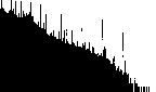
Plate 7.
Click on the image
to view larger size.
|
|
Americas: Plate 7 has significant, narrow spikes at approximately 150m (500ft) intervals, with secondary spikes at several lesser intervals. This suggests that a variety of contour intervals was
available in the DEM source maps. The semi-logarithmic plot is not linear as are a few other semi-log plots of other DEMs. Modest peaks (broader than spikes) in the histogram occur between 250 - 300m (just short of 1000ft), and 650 - 700m (just
above 2000ft). Between 700m and 1200m the histogram is relatively smooth, with superimposed spikes. Modest peaks occur around 1200m and above, at similar values to those of spikes. This suggests that vertical granularity of the data is coarsest
at 1200m (4000ft) and above. At such higher elevations, major spikes occur at approximately 300m (1000ft) intervals. Such spikes exist at lower elevations, but they are less prominent.
|

Plate 8.
Click on the image
to view larger size.
|
|
Africa: Plate 8 is also somewhat similar to that for the median and nearest neighbor resamplings (source/lineage categories 2 and 3). This linear plot shows a granularity, but at about 500m and
1000m, with a subsidiary peak at about 100m. The sharp spike at 1121m is caused by Lake Beysehit in Turkey. These data appear in limited areas in GLOBE as they were overwritten by DTED discrete (source/lineage category 1) data in most areas.
|

Plate 9.
Click on the image
to view larger size.
|
|
Africa-Eurasia blend: Plate 9 shows data used only in a small portion of GLOBE. The data were overwritten by DTED discrete (source/lineage category 1) data in most areas. The Anatolian Plateau
dominates the data set, with elevations about 1000m. The major spikes in the data set represent lakes and playas in Turkey. For example, the spike at 892m (2055 grid cells, compared to 300 - 600 grid cells for similar elevations) corresponds to
Lake Tuzand. The spike at 1634m (5455 grid cells, compared to 300 - 320 cells for similar elevations) corresponds to Lake Van.
|

Plate 10.

Plate 11.
Click on each image
to view larger size.
|
|
Two additional DTED derivations were used in North America:
DMA/NCEI: Plate 10 shows spikes about every 150m (500ft), with broader peaks about 300m and 600m. As with other DEMs for North America, a cartographic lineage appears to dominate these data.
DMA/USGS: Plate 11 shows an almost linear decline in frequency of occurrence below about 3500m of elevation, with superimposed spikes denoting concentrations of elevation values at various
intervals. The major increments shown by the most prominent spikes are about every 300m (1000ft), with lesser intervals at about 150m (500ft) and 75m (250ft). Below 250m, smaller subsidiary contour intervals appear to have been included in the
source materials for this DEM.
|
Other Assessments: DTED Level 0 (the .dt0 and .mmm files on NIMA's Web site) generally contains four values of elevation for each 30" grid cell where 3" data are available. The following countries have 3" DTED
coverage: United Kingdom, France, Greece, Turkey, Cyprus, Israel, South Korea, and Iceland. However, permission had not been received in time to place DTED Level 0 coverage at NIMA's Web site by October 1996. Subsequent permission allowed USGS
to derive 30" DEMs for all these countries but the United Kingdom.
DTED Level 0 data were produced by NIMA at consistent decimation rates, rather than for consistent grid spacings. USGS resampled DTED to constant 30" grid spacings poleward of 50o latitude, where permissible. Thus, poleward of
50o North and South latitudes, DTED Level 0 resolution is less than GTOPO30’s.
In order to maintain consistent cell-centered georegistration, an 11x11 array of 3" DTED Level 1 grid cells should have been sampled to arrive at DTED Level 0 values. Thus, there is a very slight misregistration implied by the 10x10 array
actually used to make DTED Level 0. Considering the other variabilities in current global DEM compilation, this should be of minor consequence.
DTED Levels 1 and 0 are integer values, as are other DEMs used here, resulting in some artifacts in low-lying areas.
Peer review encouraged by NGDC resulted in the discovery that DTED Level 0 "mean" data were frequently lower than DTED Level 0 "minima." Further investigations at NGDC (now NCEI) suggest that this pattern varies by location--some areas
experience this phenomenon more than others. To date, NIMA has not updated these data. Discussions with peer reviewers led to the consensus that NIMA discrete (spot) sample values, though displaced to the southwestern corners of the 30" grid
cells, were the most globally consistent and desirable candidate data for their areas of coverage, between 50o North and South latitude, when other national sources were not better. Where USGS and NGDC have 30" data with
cell-centered nearest-neighbor georeferencing, NIMA discrete (spot) data may have less desirable georeferencing. However, NIMA includes several updates and improvements not available in the older versions available through NCEI and USGS.
In addition to these observations, original characteristics of DTED, noted in Section 5.A.i.a still apply to DTED Level 0, with minor alterations due to the different resolution of the 30" data.
The median, nearest-neighbor, and "breakline" versions within GTOPO30 are not shown in the GTOPO30 source map available from USGS. As these may affect applications of the data, we have attempted to illustrate where each version is
located. We have modified our source map for GTOPO30 data, as well as our source map for GLOBE data, to reflect these different derivations, based on descriptions of the process from USGS scientists. USGS's blend between breakline and median
data processing is also depicted on GLOBE’s source/lineage map (shown in Section 11.E), where such data are used.

Return to Report Introduction
|
