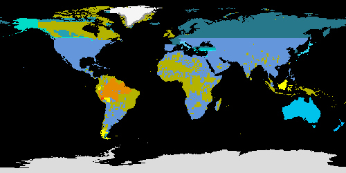
The "?10S" files (and single "L10T" file) are a tiled source map, these files also contain lineage information denoting post-source processing. Each such file is a simple 8-bit (byte) binary image which has values that indicate
the source used to derive the elevation for every cell in the DEM, plus the subsequent lineage of processing used to derive the DEM. The source/lineage map is the same resolution and has the same dimensions and coordinate system as the DEM. Like
the DEM, it has no header or trailer bytes and is stored in row major order. These codes are used in the source map image:
|
|
Code
|
Source/Lineage (with section of this document that describes source/lineage)
|

|
0
|
Ocean.
|

|
1
|
DTED Level 0 discrete (spot) 30" DEM, sampled from the southwestern corner of the 30" GLOBE grid cell. (More information in Section 5.A.i.)
|

|
2
|
DTED-based 30" median DEM from USGS/GTOPO30. (More information in Section 5.A.i.)
|

|
3
|
DTED-based nearest-neighbor (to center of 30" GLOBE grid cell) DEM from USGS/GTOPO30. (More information in Section 5.A.i.)
|

|
4
|
DTED resampled to 30" by NIMA, provided to NGDC for public distribution in the 1980s. Spot (nearest-neighbor) version used. (More information in Section 5.A.i.)
|

|
5
|
DTED provided to USGS for public distribution in the 1970s, regridded to 30" by nearest-neighbor techniques by USGS. (More information in Section 5.A.i.)
|

|
6
|
DTED-based 30" “breakline” DEM from USGS/GTOPO30. (More information in Section 5.A.i.)
|

|
7
|
DTED-based DEM. Linear blending between classes 2 and 6 at their suture. (More information in Section 5.A.i.)
|

|
8
|
DEM for Australia. AUSLIG point elevation data base for Australia, converted to 30" DEM by NGDC (copyright 1998 by AUSLIG, licensed to NGDC for distribution with GLOBE). (More information in Section 5.A.ii.)
|

|
9
|
DEM of Japan, from GSI. (More information in Section 5.A.iii.)
|

|
10
|
DEM for Italy at high resolution from SGN, converted to 30" gridding by NGDC (for SGN). (More information in Section 5.A.iv.)
|

|
11
|
DEM of New Zealand at 500m gridding by LCR, reprojected to 30" by USGS. (More information in Section 5.A.v.)
|

|
12
|
DEM of Greenland at 90" by NSIDC, converted to 30" by JPL. (More information in Section 5.A.vi.)
|

|
13
|
Zwally (and others)/NSIDC/JPL and DCW blended DEM. Linear blending between classes 12 and 14 at their suture. (More information in Sections 5.A.vi. and 5.B.i.d.)
|

|
14
|
Digital Chart of the World. Developed by DMA from 1:1,000,000-scale maps, converted to 30" grid by USGS. (More information in Section 5.A.vii.)
|

|
15
|
Maps for parts of southeast Asia and South America at 1:1,000,000 scale by AMS, digitized by GSI, gridded at 30" by USGS. (More information in Section 5.A.viii.)
|

|
16
|
Maps for part of Brazil. Produced at 1:1,000,000 scale by the Fundacao Instituto Brasiliero de Geografia e Estatistica of Brazil as part of the International Map of the World series, adapted to digital vectors by GSI, gridded at 30" by
USGS. (More information in Section 5.A.ix.)
|

|
17
|
Map for part of Peru produced at 1:1,000,000 scale by the Ministerio de Guerra of Peru, adapted to digital vectors by GSI, gridded at 30" by USGS. (More information in Section 5.A.x.)
|

|
18
|
SCAR Antarctic Digital Database, converted to 30" DEM by USGS, subsequently repaired by NGDC. (More information in Section 5.A.xi.)
|
The cells with code 0 (ocean) in the source map can be used as an ocean mask. The ocean cells match exactly all the cells masked as "no data" in the DEM with a value of -500. Likewise, the cells with codes 1 - 18 together constitute a
global land mask. Every cell in the DEM with an elevation has a corresponding cell in the source map with a code in the range 1 - 18.


