Introduction
IHY-Africa kickoff meeting
Integrated Preciptable Water and Total Electron Content
Africa GPS database at NGDC
GPS Efforts at NOAA
Concluding remarks
References
|
Other GPS Applications at NOAA
The wide range of GPS applications in the Oceanic and Atmospheric sciences makes GPS one of most important datasets held at the National Geophysical Data Center.
Mike Alasken - NGS |
Land Surveying
Reference stations can be used for accurate and cost effective surveying of infrastructure. Dynamic surveying is also possible allowing engineers to update site surveys as construction is taking place |
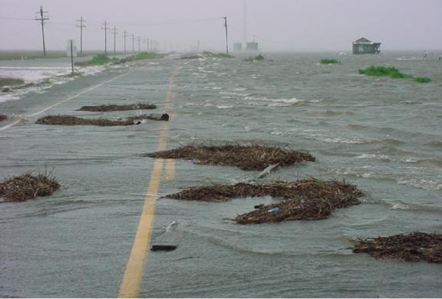
Emergency Response Management
During Hurricane Katrina reference stations gave NOAA scientists the tools they needed to predict the path of the storm surge. This allowed Emergency Management officials to change evacuation routes with short notice, saving many lives. The pictured coastal highway was a designated evacuation route until re-assessed by Emergency Management officials.. |
|

John Kyle - NWS |
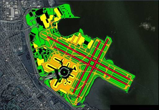
Digital Elevation Mapping, LIDAR, and Watershed Analysis
This image represents a number of GPS applications working together. Reference stations allow for accurate positioning of moving platforms, such as aircraft. When used in conjunction with LIDAR, a single aircraft can obtain an accurate profile of terrain features. This Digital Elevation Map was created using this method. This region suffered a signifcant forest fire that damaged vegetation and polluted the watershed with the resulting burn products. NOAA scientists were able to use these techniques in conjunction to evaluate how the pollutants will effect the watershed. This research allows for more effective water resource management. |
Agriculture and Land Use
NOAA scientists have been able to assist in agricultural development and land use planning through use of GPS technology. This image identifies regions of geographic features and soil properties preferential to location and growth of various plant species. This application of GPS technology is designed to assist in the recovery of barrier islands seriously damaged by tropical storms. Other applications include maximizing crop yield, water use, and irrigation pathways.
|

Thomas Landon - NOS |

Andrea Bilich - NGS |
Seismology and Tectonics
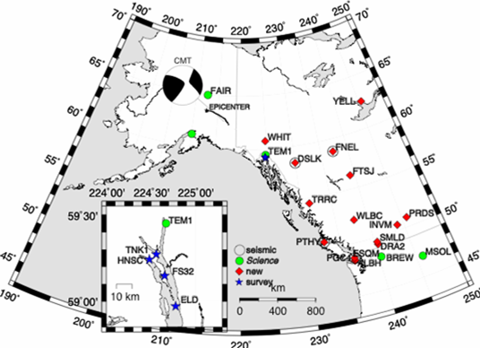
Left: The map of Alaska and Brittish Columbia show the locations of GPS reference stations used to evalue the propogation of the earthquake radial and traverse waves during the 2003 Denali Fault Earthquake. This type of analysis gives us insight on how the disturbance propogates and even provides detail on ground composition between sites.
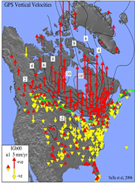
Below: Crustal heaving can be analyzed using GPS technology. During the last ice age, much of North America was covered with a heavy ice sheet which pushed down the undelying land mass. Since the ice has retreated, the continent has been rebounding (represented by red arrows). In response, we can also see settling that is occuring in lower latitude regions where the ice sheet was not present. Crustal heaving also helps us correct for significant errors in evaluating sea level change by integrating crustal heaving into values of sea level change measured at coastal reference stations.
Richard Snay - NGS |
Navigation
Coastal reference stations allow accurate navigation of marine traffic. First by using the reference station to conduct accurate bathymetric soundings, the geography of the ocean floor can be assessed. Later, marine traffic can use reference station data to accurately navigate difficult waterways. This includes the ability to avoid collision with underwater obstacles and even, with the help of radar, allows blind navigation during periods of dense fog and severe weather. |
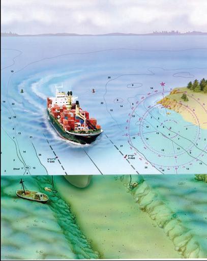
Gerd Glang - NOS |
|